
Recomendados
Recomendados
Más contenido relacionado
La actualidad más candente
La actualidad más candente (20)
Destacado
Destacado (20)
Similar a Smp2 part b policy statements kingston seymour only_final
Similar a Smp2 part b policy statements kingston seymour only_final (20)
Más de Severn Estuary
Último
Último (20)
Smp2 part b policy statements kingston seymour only_final
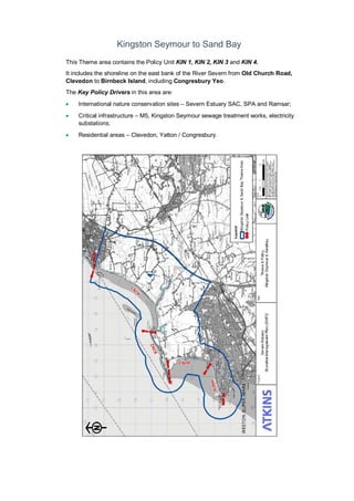
- 1. Kingston Seymour to Sand Bay This Theme area contains the Policy Unit KIN 1, KIN 2, KIN 3 and KIN 4. It includes the shoreline on the east bank of the River Severn from Old Church Road, Clevedon to Birnbeck Island, including Congresbury Yeo. The Key Policy Drivers in this area are: • International nature conservation sites – Severn Estuary SAC, SPA and Ramsar; • Critical infrastructure – M5, Kingston Seymour sewage treatment works, electricity substations; • Residential areas – Clevedon, Yatton / Congresbury.
- 3. Policy Unit: KIN 1 - Old Church Road, Clevedon to St Thomas’ Head (east bank of the River Severn)
- 4. Preferred Policies to Implement the Plan: Epoch Preferred Policy Comments 0 to 20 years (2025) MR The Short Term policy for this unit is Managed Realignment. The current defences along the coastal shoreline (reinforced earth embankments) are expected to remain in place for this epoch with little maintenance. MR in this epoch should focus on the area around Congresbury Yeo, where a MR scheme is currently being developed. This approach manages the risk of impacts from flooding to this and linked Policy Units (KIN 3, KIN 4). MR does not guarantee funding to build or maintain new realigned defences. 20 to 50 years (2055) MR The medium term policy for this unit is a Managed Realignment policy. The existing defences along the coastal shoreline will come to the end of their serviceable life in this epoch. MR in this epoch should focus on the creation of new, realigned defences along the shoreline to the north (Commissioner’s Bank) and south of Congresbury Yeo to enable new intertidal habitat to be created. MR manages the risk of impacts from flooding to this and linked Policy Units (KIN 3, KIN 4). The position, size and materials of new defences should be considered in detail and determined by the SEFRMS. Land, nature conservation and historic environment features in front of the new line of defences or in areas of NAI will be at increased risk of flooding and erosion. Adaptation actions should be considered and implemented where appropriate. The habitat created in this Policy Unit will help compensate for areas lost elsewhere in the estuary and help maintain/improve the condition of the European protected sites. MR does not guarantee funding to build or maintain new realigned defences. 50 to 100 years (2105) MR The long term policy for this unit is Managed Realignment. New realigned defences should be maintained and further MR along the shoreline to the north (Commissioner’s Bank) and south of Congresbury Yeo should be considered as and when defences created in the previous epoch need to be replaced. MR manages the risk of impacts from flooding to this and linked Policy Units (KIN 3, KIN 4). The position, size and materials of new defences should be considered in detail by the SEFRMS. Land, nature conservation and historic environment features in front of the new line of defences or in areas of NAI will be at increased risk of flooding and erosion. Adaptation actions should be considered and implemented where appropriate. The habitat created in this Policy Unit will help compensate for areas lost elsewhere in the estuary and help maintain/improve the condition of the European protected sites. MR does not guarantee funding to build or maintain new realigned defences.
- 5. Economics Policy Unit Existing SMP1 Policy Time Period (epoch) SMP2 Assessment 0- 20 20- 50 50- 100 Preferred Plan Present Value Damages Preferred Plan Present Value Defence Costs KIN 1 HTL MR MR MR £3,172m (KIN1, 3, 4 total) £15m (KIN1, 3, 4 total) The preferred policy is economically viable for the linked Policy Units of KIN 1, KIN 3 and KIN 4. The costs and damages of the preferred policy in the table above relate to actions taken in all linked policy units.
- 6. Predicted Implication of the Preferred Plan for the KIN 1 Policy Unit Time Period Management Activities Property, Land Use and Human Health Nature Conservation – including Earth Heritage, Geology and Biodiversity Landscape Character and Visual Amenity Historic Environment Amenity and Recreational Use 0 – 20 years The existing defences will remain in place along the coastal shoreline. A MR scheme in Congresbury Yeo is underway and will need to be maintained when completed. Present defences will remain in place along the coastal shoreline, managing the risk of impacts from flooding to properties and land. MR in Congresbury Yeo will manage the risk of impacts to properties and land behind the defences. There will be limited impact in this epoch as the existing defence line remains in place. The MR scheme in Congresbury Yeo has been agreed and will create some additional intertidal habitat. Works should take account of possible environmental impacts and the need for an EIA. Limited erosion and flood risk will not impact on existing landscape and visual amenity. The MR scheme in Congresbury Yeo has been agreed and will a slight impact on landscape and visual amenity Defences will manage the risk to the historic environment. The MR scheme in Congresbury Yeo has been agreed and may have a slight impact on historic environment. Defences will manage the risk to amenity and recreational assets. The MR scheme in Congresbury Yeo has been agreed and may have a slight impact on amenity. 20 – 50 years Existing defences along the coastal shoreline are expected to come to the end of their serviceable life during this epoch. Prior to complete failure of the existing earth embankment, new set back defences, should be established to allow habitat creation and to reduce the impact from fluvial flooding by increasing floodwater conveyance. Realigned defences will manage the risk of impacts to properties and land behind new defences. Assets in front of realigned defences will be at risk from inundation. Impacts on property and land, and mitigation actions will need to be considered in determining realignment of defences. A MR policy may benefit flood risk management in adjacent, linked Policy Units (KIN 3, KIN 4). A MR policy will allow the creation additional intertidal habitat. There will be loss of terrestrial habitats as intertidal habitats roll back. Works should take account of possible environmental impacts and the need for an EIA. The creation of intertidal habitat will replace existing agricultural land, altering the landscape. Realigned defences will manage the risk of impacts to historic environment assets behind new defences. Assets in front of realigned defences will be at risk from inundation. Managed re-alignment is likely to adversely impact on a limited number of listed buildings. Impacts on historic environment assets, and mitigation actions, will need to be considered in determining realignment of defences Realigned defences will manage the risk on the amenity value or recreational use of the land behind new defences. Impacts on recreational assets, and mitigation actions, will need to be considered in determining realignment of defences
- 7. Time Period Management Activities Property, Land Use and Human Health Nature Conservation – including Earth Heritage, Geology and Biodiversity Landscape Character and Visual Amenity Historic Environment Amenity and Recreational Use 50 – 100 years The new defence line should be maintained. A further MR of defences should be considered as and when defences created in the previous epoch need to be replaced. Realigned defences will manage the risk of impacts to properties and land behind new defences. Assets in front of realigned defences will be at risk from inundation. Impacts on property and land, and mitigation actions will need to be considered in determining realignment of defences. A MR policy may benefit flood risk management in adjacent, linked Policy Units (KIN 3, KIN 4). A MR policy will allow the creation additional intertidal habitat. There will be loss of terrestrial habitats as intertidal habitats roll back. Works should take account of possible environmental impacts and the need for an EIA. In the long term sea level rise will result in more frequent flooding of the seaward side of the defence line and creation of intertidal habitat, altering the landscape. Realigned defences will manage the risk of impacts to historic environment assets behind new defences. Assets in front of realigned defences will be at risk from inundation. Managed re-alignment is likely to adversely impact on a limited number of listed buildings. Impacts on historic environment assets, and mitigation actions, will need to be considered in determining realignment of defences Realigned defences will manage the risk on the amenity value or recreational use of the land behind new defences.
- 8. Policy Unit: KIN 2 - St Thomas’ Head to Middle Hope car park at Sand Point (east bank of the River Severn)
- 9. Preferred Policies to Implement the Plan: Epoch Preferred Policy Comments 0 to 20 years (2025) NAI The short term policy for this unit is No Active Intervention. High ground and hard geology naturally limit the risk of coastal flooding and erosion in this Policy Unit. NAI will allow natural processes to continue with little or no impact. This Policy Unit is not linked to any others. 20 to 50 years (2055) NAI The medium term policy for this unit is No Active Intervention. High ground and hard geology naturally limit the risk of coastal flooding and erosion in this Policy Unit. NAI will allow natural processes to continue with little or no impact. This Policy Unit is not linked to any others. 50 to 100 years (2105) NAI The long term policy for this unit is No Active Intervention. High ground and hard geology naturally limit the risk of coastal flooding and erosion in this Policy Unit. NAI will allow natural processes to continue with little or no impact. This Policy Unit is not linked to any others. Economics Policy Unit Existing SMP1 Policy Time Period (epoch) SMP2 Assessment 0- 20 20- 50 50- 100 Preferred Plan Present Value Damages Preferred Plan Present Value Defence Costs KIN 2 Do nothing NAI NAI NAI Minimal Minimal The preferred policy has no economic impact in this Policy Unit. This Policy Unit is not linked to any others.
- 10. Predicted Implication of the Preferred Plan for the KIN 2 Policy Unit Time Period Management Activities Property, Land Use and Human Health Nature Conservation – including Earth Heritage, Geology and Biodiversity Landscape Character and Visual Amenity Historic Environment Amenity and Recreational Use 0 – 20 years The shoreline will remain stable in this period, and as a result management activities will be limited. Limited erosion and flood risk will not impact on existing property, land use or human health. A NAI policy will allow natural processes to dominate. There will be continued exposure of Middle Hope SSSI. Limited erosion and flood risk will not impact on existing landscape and visual amenity Limited erosion and flood risk will not impact on the historic environment Limited erosion and flood risk will not impact on the amenity value of the land or recreational use. 20 – 50 years The shoreline will undergo limited erosion within this period, and as a result management activities will be limited. Limited erosion and flood risk will not impact on existing properties, land use or human health. A NAI policy will allow habitats to roll back so intertidal habitats and features will be maintained. Roll back will be limited due to restriction by hard geology and high ground. There will be continued exposure of Middle Hope SSSI. Limited erosion and flood risk will not impact on existing landscape and visual amenity Limited erosion and flood risk will not impact on the historic environment Limited erosion and flood risk will not impact on the amenity value of the land or recreational use. 50 – 100 years The shoreline will undergo limited erosion within this period, and as a result management activities will be limited. Limited erosion and flood risk will not impact on existing properties, land use or human health. A NAI policy will allow habitats to roll back so intertidal habitats and features will be maintained. Roll back will be limited due to restriction by hard geology and high ground. There will be continued exposure of Middle Hope SSSI. Limited erosion and flood risk will not impact on existing landscape and visual amenity Limited erosion and flood risk will not impact on the historic environment Limited erosion and flood risk will not impact on the amenity value of the land or recreational use.
- 11. Policy Unit: KIN 3 - Middle Hope car park at Sand Point to the southern end of Beach Road, Kewstoke (east bank of the River Severn)
- 12. Preferred Policies to Implement the Plan: Epoch Preferred Policy Comments 0 to 20 years (2025) HTL The Short Term policy for this unit is Hold The Line. HTL requires the active management of the sand dunes, which are the main line of defence. The sand dunes will remain in place in during this epoch, managing the impacts of coastal flooding. Historic accretion at the north end of this Policy Unit is expected to continue. HTL is expected to require only minimal management of the sand dunes. HTL does not guarantee funding to build or maintain current or future defences or to counter sea level rise. 20 to 50 years (2055) HTL The medium term policy for this unit is Hold The Line. HTL requires the active management of the sand dunes, which are the main line of defence. This will manage the risk of impacts from flooding and erosion. Historic accretion at the north end of this Policy Unit is expected to stop and possibly reverse (start to erode), as sea level rises. Actions should take account of impacts on linked Policy Units (KIN 1, KIN 4). HTL does not guarantee funding to build or maintain current or future defences or to counter sea level rise. 50 to 100 years (2105) HTL The long term policy for this unit is Hold The Line. HTL requires the active management of the sand dunes, which are the main line of defence. This will manage the risk of impacts from flooding and erosion. Historic accretion at the north end of this Policy Unit is expected to reverse (start to erode), as sea level rises. Actions should take account of impacts on linked Policy Units (KIN 1, KIN 4). HTL does not guarantee funding to build or maintain current or future defences or to counter sea level rise. Economics Policy Unit Existing SMP1 Policy Time Period (epoch) SMP2 Assessment 0- 20 20- 50 50- 100 Preferred Plan Present Value Damages Preferred Plan Present Value Defence Costs KIN 3 HTL HTL HTL HTL £3,172m (KIN1, 3, 4 total) £15m (KIN1, 3, 4 total) The preferred policy is economically viable for the linked Policy Units of KIN 1, KIN 3 and KIN 4. The costs and damages of the preferred policy in the table above relate to actions taken in all linked policy units.
- 13. Predicted Implication of the Preferred Plan for the KIN 3 Policy Unit Time Period Management Activities Property, Land Use and Human Health Nature Conservation – including Earth Heritage, Geology and Biodiversity Landscape Character and Visual Amenity Historic Environment Amenity and Recreational Use 0 – 20 years The shoreline will remain stable (accretion to the north) and constrained flooding in this period will result in minimal management activities. Limited erosion and flood risk will not impact on existing property, land use or human health. A HTL policy will not impact the nature conservation sites during this time period. Works should take account of possible environmental impacts and the need for an EIA. Limited erosion and flood risk will not impact on existing landscape and visual amenity Limited erosion and flood risk will not impact on the historic environment Management of sand dunes will manage the risk to the amenity value of the land or recreational use. 20 – 50 years The sand dunes that form the defence are expected to come to the end of their serviceable life during this epoch. A management programme to maintain the dunes should be implemented to maintain the shoreline. Management of sand dunes will manage the risk to property, land use or human health. Coastal squeeze will occur which will result in loss of intertidal habitats. Management of sand dunes is likely to impact upon to integrity of the SSSI. Works should take account of possible environmental impacts and the need for an EIA. Management of sand dunes will help maintain the visual character of the area. Management of sand dunes will manage the risk to the historic environment Management of sand dunes will manage the risk to the amenity value of the land or recreational use. 50 – 100 years The sand dunes should continue to be maintained. Monitoring of shoreline erosion should also be undertaken. Management of sand dunes will manage the risk to property, land use or human health. Coastal squeeze will occur which will result in loss of intertidal habitats. Management of sand dunes is likely to impact upon to integrity of the SSSI. Works should take account of possible environmental impacts and the need for an EIA. Management of sand dunes will help maintain the visual character of the area. Management of sand dunes will manage the risk to the historic environment Management of sand dunes will manage the risk to the amenity value of the land or recreational use.
- 14. Policy Unit: KIN 4 - the southern end of Beach Road, Kewstoke to Birnbeck Island (east bank of the River Severn)
- 15. Preferred Policies to Implement the Plan: Epoch Preferred Policy Comments 0 to 20 years (2025) NAI The short term policy for this unit is No Active Intervention. High ground and hard geology naturally limit the risk of coastal flooding and erosion in this Policy Unit. NAI will allow natural processes to continue with little or no impact. 20 to 50 years (2055) NAI The medium term policy for this unit is No Active Intervention. High ground and hard geology naturally limit the risk of coastal flooding and erosion in this Policy Unit. NAI will allow natural processes to continue. The rate of erosion in the medium (and long) term is unclear and should be monitored. If the rate of erosion increases, or properties are at risk, action should be considered. Funding is not guaranteed. 50 to 100 years (2105) NAI The long term policy for this unit is No Active Intervention. High ground and hard geology naturally limit the risk of coastal flooding and erosion in this Policy Unit. NAI will allow natural processes to continue. The rate of erosion in the medium (and long) term is unclear and should be monitored. If the rate of erosion increases, or properties are at risk, action should be considered. Funding is not guaranteed. Economics Policy Unit Existing SMP1 Policy Time Period (epoch) SMP2 Assessment 0- 20 20- 50 50- 100 Preferred Plan Present Value Damages Preferred Plan Present Value Defence Costs KIN 4 Do Nothing (Locally HTL) NAI NAI NAI £3,172m (KIN1, 3, 4 total) £15m (KIN1, 3, 4 total) The preferred policy has no economic impact in this Policy Unit. The preferred policy is economically viable for the linked Policy Units of KIN 1, KIN 3 and KIN 4. The costs and damages of the preferred policy in the table above relate to actions taken in linked policy units, not in KIN 4.
- 16. Predicted Implication of the Preferred Plan for the KIN 4 Policy Unit Time Period Management Activities Property, Land Use and Human Health Nature Conservation – including Earth Heritage, Geology and Biodiversity Landscape Character and Visual Amenity Historic Environment Amenity and Recreational Use 0 – 20 years The shoreline will remain stable in this period, and as a result management activities will be very limited. Limited erosion and flood risk will not impact on existing property, land use or human health. Flood risk to property and land use from linked Policy Units (KIN 1, KIN 3, adjacent SMP2 area) – cannot be affected by shoreline management actions within KIN 4. A NAI policy will allow natural processes to dominate. Limited erosion and flood risk will not impact on existing landscape and visual amenity Limited erosion and flood risk will not impact on the historic environment Limited erosion and flood risk will not impact on the amenity value of the land or recreational use. 20 – 50 years The shoreline will undergo limited erosion within this period, and as a result management activities will be limited. Limited erosion and flood risk will not impact on existing properties, land use or human health. Flood risk to property and land use from linked Policy Units (KIN 1, KIN 3, adjacent SMP2 area) – cannot be affected by shoreline management actions within KIN 4. A NAI policy will allow habitats to roll back so intertidal habitats and features will be maintained. Roll back will be limited due to restriction by hard geology and high ground. Limited erosion and flood risk will not impact on existing landscape and visual amenity Limited erosion and flood risk will not impact on the historic environment Limited erosion and flood risk will not impact on the amenity value of the land or recreational use. 50 – 100 years The shoreline will undergo limited erosion within this period, and as a result management activities will be limited. Limited erosion and flood risk will not impact on existing properties, land use or human health. Flood risk to property and land use from linked Policy Units (KIN 1, KIN 3, adjacent SMP2 area) – cannot be affected by shoreline management actions within KIN 4. A NAI policy will allow habitats to roll back so intertidal habitats and features will be maintained. Roll back will be limited due to restriction by hard geology and high ground. Limited erosion and flood risk will not impact on existing landscape and visual amenity Limited erosion and flood risk will not impact on the historic environment Limited erosion and flood risk will not impact on the amenity value of the land or recreational use.