
Recomendados
Más contenido relacionado
Destacado
Destacado (14)
Más de Shomou' Aljizawi
Más de Shomou' Aljizawi (10)
Último
Último (20)
Al ramtha city jordan surface potential map, final2
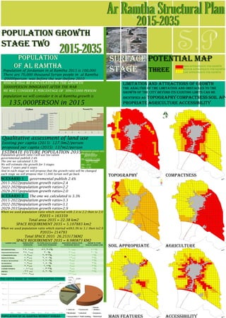
- 1. ESTIMATE FUTURE POPULATION 2035 Population growth ratio I will use two ration governmental publish 2.4% The one we calculated 3.3% We will estimate the growth for 3 stages 7years 7 years and 6 years And in each stage we will propose that the growth ratio will be changed each stage we will propose that 11,666 Syrian well go back scenario 1 governmental publish 2.4% 2015-2022population growth ratio=2.4 2022-2029population growth ratio=2.2 2029-2035population growth ratio=2.0 scenario 2 The one we calculated is 3.3% 2015-2022population growth ratio=3.3 2022-2029population growth ratio=3.1 2029-2035population growth ratio=2.9 S.P S.PAr Ramtha Structural Plan 2015-2035 When we used population ratio which started with 2.4 to 2.2 then to 2.0 P2035 = 163359 Total area 2035 = 22.38 km2 SPACE REQUIREMENT 2035 = 5.107883 km2 When we used population ratio which started with3.3% to 3.1 then to2.9 P2035= 214793 Total SPACE 2035 26.253173KM2 SPACE REQUIREMENT 2035 = 8.980873 KM2 population growth stage two topography compactness surface potential map stage three limitation and attractions of growth the analysis of the limitation and obstacles to the growth of the city beyond its existing limits can be identified as topography compactness soil ap- propriate agriculture accessibility 2015-2035 population of al ramtha Qualitative assessment of land use Existing per capita (2015) 127.9m2/person proposed per capita (2035) 137m2/person Population of Jordanian in al Ramtha 2015 is 100,000 There are 70,000 thousand Syrian people in al Ramtha (20000person was before the war (before 2010 WHICH WELL BE CALCULATED IN THE GROWTH 50000PERSON IMMIGRANT AFTER THE WAR WE WILL CONSIDER A PERCENTAGE OF 30%=15000 PERSON population we will consider it in al Ramtha growth is 135,000PERSON in 2015 Population growth ratio PR=P(t2)-P(t1 PR=95000-71300 PR= .033 PR= 3.3% Population growth ratio 10 *71300 (P(t1) (t2-t1 per capita share (m²/person) for ramtha citizine population of al ramtha without syrian high appropriate for growth medium appropriate for growth low appropriate for growth soil appropriate main features agriculture accessibility N