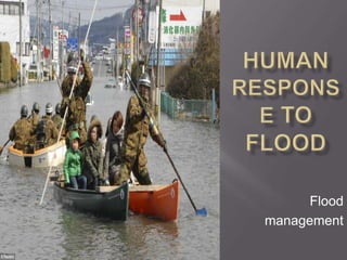
2. IMMEDIATE LONG TERM
Provide boats to rescue Prediction
people
Hydrograph analysis
Supply medicines to treat Real-time monitoring
and prevent spread of Studying past records
diseases
Supply clean water Hard Engineering
Distribute food and Soft Engineering
temporary housing (tents)
Aids from foreign countries
3. a. Hydrograph Analysis:
- analysing a series of storm hydrographs for a basin, it is
possible to device estimates for the behavior of the river for
storms of different sizes
b. Real time monitoring:
1. A series of monitoring stations are set up along the rivers
2. Automatic measurements are sent to a central flood control office
3. allows hydrologist to follow the progress of flood waves down rivers
4. It is expensive and difficult to set up esp in remote areas
c. Studying past records:
1. Enables people to workout the likelihood of floods of
different sizes
4. Involve in trying to
lengthen the amount of
time it takes for water to
reach the river channel
increasing the lag time
Flood management
techniques:
Hard Engineering options
Soft Engineering options
5. Hard
Engineering • More expensive
• Have greater impact on the river and the
Options surrounding landscape
Soft
Engineering
Options • More ecologically sensitive
6. Hard Engineering Soft Engineering
options options
• Dam Construction • Afforestation
• River Engineering: • Ecological Flooding
realignment /
Channelisation
• Planning
• Revetment, e.g River
Yangtze, China • Flood warnings
• (Refer pg 61-62 of yr booklet) • Public relief /
Emergency action
7. HARD ENGINEERING SOFT ENGINEERING
Dam Construction Afforestation
River Engineering:
realignment / Ecological Flooding
Channelisation
Planning
Revetment, e.g
River Yangtze, Flood warnings
China
(Refer pg 61-62 of yr Public relief /
booklet Emergency act
8. • Store and control river discharge
Dams • Used to control tributaries of the Mississippi , e.g River
Missouri
Levees & • By raising the height of river banks, water can be contained
retaining • Flood walls in York (Nov 2000) contained record levels and
saved many homes from flooding
walls
• Increase the speed of flow and reduces the length of the
Straightening
river
meanders
• (R. Mississippi has been shortened by over 24km)
Flood • Provides additional channels alongside existing course of river
relief • Maidenhead, Windsor and Eton relief Channel removed 5500
homes from the threat of Thames floodwater
channels
15. • Increase interception
Afforestation • Reduces run-off
• E.G Tennessee river valley, a tributary of R. Mississippi
• Floodplain zoning
Planning
• Allows certain areas to flood naturally
regulations
• Land uses are limited to grazing and recreation
Contour
ploughing in • Reduce the amount of surface run-off
Semi-arid • Reduce the liabilty to flooding
area
16. • Protect the natural river channel & valley
Wetland and
riverbank • Maintained habitat and species diversity
conservation
schemes • Arable land is returned to its former use as natural
meadowland
• In times of high discharge sluice gates are opened and
water Is allowed to flood adjacent areas
Washlands or
Spillways
• A new washland in Yorkshire saved many homes in
Dorncaster from flooding in 2007
Forecasting • In Bangladesh, the yearly floods which engulf most of the
floods and countryside cannot be prevented, but people are given
warnings enough warning they can take refuge in flood shelters
17. Largest hard-engineering
project ever undertaken
on a river
When: 2009
Location: Yangtze River
3 gorges:
Qutang gorge
Wu Gorge
Xiling Gorge
18.
19. Generate up to 22 500MW of power, reducing the
country’s dependence on coal
Largest power station in the world
Supply Shanghai’s 13 million people with water
Protect 10 million people from flooding
Water level will be raised to allow shipping above
the Three Gorges (formerly rapids)
20.
21. Most floods in recent years have come from
rivers that join the Yangtze below the Three
Gorges Dam
The region is seismologically active and landslides
are frequent
Silting as a result of increased deposition and the
development of a delta at the head of the lake.
Up to 1.2 million people have to be moved to make
way for the dam
22.
23. Much of the land available for resettlement is
over 800m above sea-level, cold & infertile soils
on steep slopes
Dozens of towns will be flooded e.g. Wanxian &
Fuling
Dam will interfere aquatic life – the white flag
dolphin is threatened with extinction
Archaelogical treasures wil be drowned, including
the Zhang Fei Temple
27. Intense tropical rains bring floods in the
Komadugu-Yobe river basin
Between June and August
Traditional farming focuses on the renewal
of fertile silt deposits with the floodwaters
28.
29. Approach:
Conserves the value of wetlands both economically and
environmentally
Promotes sustainable development in the area for
people and wildlife
Teaches local people about wetland management
Release large wet-season flows from Tiga and
Chawalla dams into rivers
30. Water and alluvium are distributed more fairly
Supports the traditional method of irrigation and farming
Marsh grazing land is maintained
Involves programme to monitor:
The extent of flooding and the changes in vegetation and wildlife
The use of water from village wells in order to check levels of the
water table
Competition for land between animal herders and crop farmers
Distribution of fuel-efficient wood stoves was design to
reduce wood consumption
people to resolve conflicts