A2 Poster_Sotirios Moustakas and Patrick Willems.pdf
•
0 recomendaciones•29 vistas

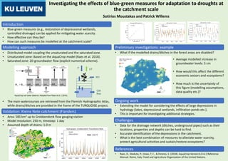
The document investigates using a distributed hydrological model at a catchment scale to analyze the effectiveness of blue-green measures for mitigating droughts. The model couples unsaturated and saturated zone processes, including an AquaCrop soil water balance model. An example preliminary investigation showed that disabling modelled forest drains and ditches increased average groundwater levels by 5 cm. Ongoing work includes extending the model to consider the effects of large depressions on hydrology.
Recomendados

Recomendados
Más contenido relacionado
Similar a A2 Poster_Sotirios Moustakas and Patrick Willems.pdf
Similar a A2 Poster_Sotirios Moustakas and Patrick Willems.pdf (20)
Más de SBO TURQUOISE
Más de SBO TURQUOISE (13)
Último
Último (20)
A2 Poster_Sotirios Moustakas and Patrick Willems.pdf
- 1. Investigating the effects of blue-green measures for adaptation to droughts at the catchment scale • Blue-green measures (e.g., restoration of depressional wetlands, controlled drainage) can be applied for mitigating water scarcity. • How effective can they be? • How can such measures be modelled at the catchment scale? Introduction • Distributed model coupling the unsaturated and the saturated zone. • Unsaturated zone: Based on the AquaCrop model (Raes et al. 2018). • Saturated zone: 2D groundwater flow (explicit numerical scheme). • The main watercourses are retrieved from the Flemish Hydrographic Atlas, while drains/ditches are provided in the frame of the TURQUOISE project. AquaCrop soil water balance. Adapted from Raes et al. ( 2018). • What if the modelled drains/ditches in the forest areas are disabled? Sotirios Moustakas and Patrick Willems Modelling approach • Area: 585 km2 up to Grobbendonk flow gauging station • Model resolution: 250 m, timestep: 1 day • Assumed depth of drains: 1.0 m Validation: Kleine Nete catchment (Flanders) Preliminary investigations: example • Average modelled increase in groundwater levels: 5 cm • How would this affect the different economic sectors and ecosystems? • How much is the uncertainty of this figure (modelling assumptions, data quality etc.)? RO P ET GW flow NSE = 0.77 • Raes, D., Steduto, P., Hsiao, T. C., & Fereres, E. (2018). AquaCrop Version 6.0-6.1 Reference Manual. Rome, Italy: Food and Agriculture Organization of the United Nations. References • Extending the model for considering the effects of large depressions in hydrology (lakes, depressional wetlands, infiltration ponds etc.). • This is important for investigating additional strategies. Ongoing work Challenges • Data for the drainage network (ditches, underground pipes) such as their locations, properties and depths can be hard to find. • Accurate identification of the depressions in the catchment. • What is the best combination of measures to alleviate water scarcity, protect agricultural activities and sustain/restore ecosystems? - - 1:1 line