PaleoClimate™ Half-Degree Simulation for 100 Ma, Including Wetness Factors

Paleoclimate modeling is an essential component of play prediction, assisting geoscientists with characterizing source rock formation, as well as estimating the preservation habitat of those deposits. This is especially valuable for analyzing the impact of key variables such as wetness and evaporation in basin development. Traditionally, paleoclimate modeling was expensive and extremely time consuming. Now, important paleoclimate data can be leveraged quickly and effectively, improving play prediction accuracy and risk assessment, as well as lowering costs. As a parameter-driven application, PaleoClimate™ is not intended to replace robust supercomputer-based climate modeling. Rather, our quick-cycle approach will allow geoscientists to rapidly explore a wide variety of factors and fine-tune assumptions. The results will further strengthen first-pass screening accuracy and/or validate the need to invest in more sophisticated, yet costly, climate simulation. PaleoClimate™ is a rapid screening tool that employs a parametric approach to model the climate of ancient Earth. The product uses paleogeographic data as inputs for calculating a wide range of paleoclimate outputs. The elevation and distribution of land and sea for a given time is used to predict surface level pressure, which is then used to compute all other outputs, including: sea level temperature, surface temperature, wind direction and azimuth, ocean currents, coastal upwelling, and wetness. In combination with digital elevation models and other valuable data inputs from commercially and academically available plate models, as well as reconstruction layers from PaleoGIS, geologists and GIS professionals will be able to dynamically analyze and visualize a wide range of paleoclimate scenarios that may have impacted sedimentary formation. The product works in conjunction with PaleoGIS or can operate as an independent application. Both ArcGIS and open-source versions are available.

Recomendados
Recomendados
Más contenido relacionado
Destacado
Destacado (10)
Más de The Rothwell Group, L.P.
Más de The Rothwell Group, L.P. (11)
Último
Último (20)
PaleoClimate™ Half-Degree Simulation for 100 Ma, Including Wetness Factors
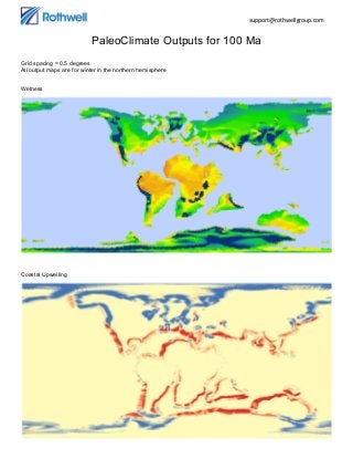
- 1. support@rothwellgroup.com PaleoClimate Outputs for 100 Ma Grid spacing = 0.5 degrees All output maps are for winter in the northern hemisphere Wetness Coastal Upwelling
- 3. support@rothwellgroup.com Sea Level Pressure Wind (closeup) – overlaying surface pressure Ocean currents (closeup) – overlaying surface pressure