1. Green the Way
Moving Forward on an
Allen Creek Trail
December 19, 2014
Matt Bourke | Hannah Dean | Matt Ferris-Smith | Ashleigh Johnson
Christopher Johnson | Luke Norman | Tolu Olorode | Tricia Pontau
Arthur Prokosch | Lucas Reigstad | Pam Schaeffer | Douglas Smith
Under the direction of Larissa Larsen & Eric Dueweke
University of Michigan Urban and Regional Planning Program
Capstone Report
3. i
GREEN THE WAY
ACKNOWLEDGEMENTS
Special thanks to Wendy Rampson and the City
of Ann Arbor for the opportunity to complete
this project and for providing knowledge and
feedback throughout. Thanks as well to the City’s
Eli Cooper, Jerry Hancock and Ethan Miller.
We would like to extend a thanks to the Allen
Creek Greenway Conservancy for their support
and enthusiasm, in particular Bob Galardi, Joe
O’Neal and Megan Barnes.
We would also like to thank the following
individuals and organizations, who provided
invaluable help and input to our project:
Robin Bailey, Ann Arbor Public Schools
Claudia Burns
Vince Caruso, Allen’s Creek Watershed Group
Steve Coron, Community High School
Mark Ferrall, Washtenaw Area Transportation
Study (WATS)
Chet Hill, Johnson Hill Land Ethics Studio
Michele Moon, Fairmount/Indigo Corridor
Collaborative (Boston, MA)
Chris Nordstrom, Johnson Hill Land Ethics
Studio
Josie Parker, Ann Arbor District Library
Laura Rubin, Huron River Watershed Council
Thank you to the Dow Sustainability Fellows
program at the Graham Sustainability Institute
for providing funding for our student art project.
We appreciate all the community members who
took time to share their thoughts on an Allen
Creek trail by stopping by our public outreach
tables, completing our survey, or attending a
community meeting on the the trail.
We thank Bethany Ramirez for her careful
reading of this report.
Lastly, we would like to extend an enthusiastic
thanks to our faculty advisors, Larissa Larsen and
Eric Dueweke, for providing excellent guidance
and leadership to our team.
5. iii
GREEN THE WAY
Table of Contents
M
OVING FORWARD ON
A
N
ALLEN CREEK TRAIL
heGREEN WAY
i Acknowledgements
v List of Figures & Tables
1 Executive Summary
5 Introduction
7 Background & Context
13 Community Input
23 Trail Features & Design
55 Recommendations
75 Works Cited
77 Appendices
7. v
GREEN THE WAY
LIST OF
FIGURES & TABLES
FIGURES
Executive Summary
Overview of the proposed Green the Way Route
Source: Green the Way
Chapter 2. Background & Context
Figure 2-1
The City’s 1988 Downtown Plan identified the
City-owned 415 W. Washington Street site as a
potential greenway park
Source: Green the Way
Figure 2-2
In 2013 the City unsuccessfully applied for
funding to create a greenway anchor park at the
721 N. Main Street site
Source: Green the Way
Figure 2-3
Flooding at Felch Street and Ashley Street in
2013. The Allen Creek valley sees frequent
floods
Source: mlive.com
Chapter 3. Community Input
Figure 3-1
Team members Matt and Arthur staffing our
public outreach table at the Ann Arbor Farmers
Market
Source: Green the Way
Figure 3-2
Green the Way’s public outreach table at the
YMCA
Source: Green the Way
Figure 3-3
Map showing where survey respondents in
Ann Arbor live. Areas in red had the highest
concentration of survey respondents.
Source: Green the Way
Figure 3-4
Map showing survey respondents’ important
destinations that should be linked to an Allen
Creek trail
Source: Green the Way
Figure 3-5
Green the Way team member Luke facilitates a
community meeting
Source: Green the Way
Figure 3-6
Washtenaw Biking and Walking Coalition
members use maps to draw potential routes and
identify important destinations
Source: Green the Way
Figure 3-7
Map showing overlay of trail routes drawn
by participants at community meetings. Most
participants drew routes along the railroad,
although there is more variation to the north.
Source: Green the Way
8. vi
GREEN THE WAY
Chapter 4. Trail Features & Design
Figure 4-1
Green the Way team studying route options
Source: Green the Way
Figure 4-2
Gateway parks, rail considerations, and road and
sidewalk crossings
Source: Green the Way
Figure 4-3
Two-lane path striping
Source: www.americantrails.org
Figure 4-4
Safety, traffic, and mile markers on the trail
surface
Source: www.americantrails.org
Figure 4-5
Trail signs and logos
Source: www.americantrails.org, www.
localmotion.org/ctc, bordertoborder.org
Figure 4-6
Small rain garden at Miller Avenue
Source: Green the Way
Figure 4-7
Large rain garden at the Ann Arbor YMCA
Source: Green the Way
Figure 4-8
Mission City Bike Trail next to Metrolink
commuter rail line, San Fernando, CA
Source: Rails to Trails Conservancy
Figure 4-9
Crossing gates installed beyond sidewalk edge
to block sidewalk and road, Ft. Collins, CO
Source: Google.
Figure 4-10
Fencing and gates at rail-trail crossing, Irvine,
CA
Source: Google Street View, accessed
2014.11.04.
Figure 4-11
Enhanced stop sign intersection along
Indianapolis Cultural Trail, featuring high-
visibility crosswalks and corner bump-outs
Source: ndyculturaltrail.org
Figure 4-12
A rendering of a speed table, a design solution
to increase safety where the trail crosses streets
mid-block
Source: NACTO Urban Street Design Guide
Figure 4-13
First Street and Liberty Street intersection
Source: Google.
Figure 4-14
First Street and William Street intersection
Source: Google.
Figure 4-15
Main Street and Madison Street intersection
Source: Google
Figure 4-16
Merge of on-road bicycle lane with side path
Source: Non-motorized Transportation Plan
(Full source-Appendix A) Figure 2.3L, Pg. 41
Figure 4-17
Trail emergency call light or blue light
Source: Town of Chapel Hill, accessed on
12/16/2014
Figure 4-18
Green the Way study routes
Source: Green the Way
Figure 4-19
The Allen Creek Greenway Conservancy
proposed this wide section of railroad property
be used as a park featuring a historic railroad
turntable
Source: Green the Way
9. vii
GREEN THE WAY
Figure 4-20
Path serving different types of users in
Madison, WI
Source: capitalbikeandwalk.org
Figure 4-21
Protected bicycle lanes like this one on
Delaware Avene in Philadelphia can provide
separate spaces for bicyclists and pedestrians
Source: thisoldcity.com
Figure 4-22
Miller Avenue rain gardens
Source: Green the Way
Figure 4-23
Football game day pedestrians using the railroad
Source: Green the Way
Figure 4-24
Segment A: S. State Street to Hill Street
Source: Green the Way
Figure 4-25
Burke-Gilman Trail near the University of
Washington
Source: www.americantrails.org
Figure 4-26
Segment B: Hill Street to Liberty Street
Source: Green the Way
Figure 4-27
Segment C: Liberty Street to Miller Avenue
Source: Green the Way
Figure 4-28
This bicycle path along the Left Hand Creek
in Boulder, CO was credited with reducing
flooding in the surrounding neighborhood
Source: www.biked.og
Figure 4-29
A cycle track (two-way protected bicycle lane)
paired with a sidewalk along the Indianapolis
Cultural Trail
Source: indyculturaltrail.org
Figure 4-30
Indianapolis Cultural Trail, a bicycle and
pedestrian path with rain gardens and local
artwork
Source: indyculturaltrail.org
Figure 4-31
Segment D: Miller Avenue to the Huron River
Source: Green the Way
Figure 4-32
A conventional street (left) was tranformed
into a bicycle and pedestrian friendly reoute
(right) with the hlep of stormwater features in
Portland, OR
Source: www.oregonlive.com
Chapter 5. Recommendations
Figure 5-1
Overview of proposed Green the Way Route
Source: Green the Way
Figure 5-2
Segment A: S. State Street to Hill Street
Source: Green the Way
Figure 5-3
On wide railroad property through UM athletic
campus, we propose a Turntable Park in this
section of the trail
Source: Green the Way
Figure 5-4
Suggested configuration for bikeway, roads,
sidewalks, and trail at Liberty Street and First
Street
Source: Green the Way
Figure 5-5
Segment B: Hill Street to Liberty Street
Source: Green the Way
10. viii
GREEN THE WAY
Figure 5-6
A dedicated bicycle stoplight gives cars a red
arrow when bicyclistis and pedstrians are
crossing on the Dearborn Street cycle track in
Chicago
Source: tcsidewalks.blogspot.com
Figure 5-7
Segment C: Liberty Street to Miller Avenue
Source: Green the Way
Figure 5-8
Segment D: Miller Avenue to the Huron River
Source: Green the Way
Figure 5-9
Phasing for the Green the Way Route
Source: Green the Way
Figure 5-10
Local Motion’s bicycle ferry
Source: www.localmotion.org
Figure 5-11
Winooski River bridge, Vermont
Source: www.enjoyburlington.com
Figure 5-12
Suggested configuration for bikeway, roads,
sidewalks, and trail at Kingsley Street and First
Street
Source: Green the Way
Figure 5-13
Posters at local businesses inform residents of
public meetings
Source: Green the Way
Figure 5-14
Overhead view of the City-owned 721 N. Main
Street site. There are a number of potential
ways to connect this site to the Border-to-
Border trail.
Source: Allen Creek Greenway Task Force
Figure 5-15
Looking south along the railroad at the East
Eisenhower Parkway
Source: Green the Way
Figure 5-16
A complete Allen Creek trail will be an asset in
Ann Arbor, much like the Indianapolis Cultural
Trail has become a part of that city’s urban
environment
Source: indyculturaltrail.org
TABLES
Chapter 3. Community Input
Table 3-1
Trail activity frequency by proximity of home to
trail
Table 3-2
Trail activity frequency by household type
Table 3-3
Strengths and weaknesses of community
outreach process
Chapter 4. Trail Features & Design
Table 4-1
Study Route statistics
Table 4-2
Study Route evaluation
Chapter 5. Recommendations
Table 5-1
Green the Way Route statistics
Table 5-2
Parking spaces removed and driveways crossed
by the East Branch of the Green the Way Route
11. EXECUTIVE SUMMARY
Moving Forward on an Allen Creek Trail shares
routing, design, and phasing recommendations
for a proposed biking and walking trail in the
City of Ann Arbor, Michigan. The trail would
connect community destinations while providing
attractive green space and enhanced stormwater
management. The trail would also be an
opportunity to improve one of the city’s defining
natural features, Allen Creek, which was buried
in 1926 and has been badly polluted for over 100
years. Increased flooding and persistent pollution
in Allen Creek, alongside a greater awareness
of stormwater management, has created a new
urgency for creative solutions like an Allen Creek
trail.
This idea is not new. First mention of an Allen
Creek trail emerged in the City’s 1981 Plan for
Park, Recreation, and Open Space, and the idea
gained momentum in the early 2000s. Although
no precise alignment of the trail has been chosen,
efforts have focused on the Allen Creek valley
and the active railroad corridor that runs through
it. The railroad and the creek are closely aligned
but follow separate paths at Miller Avenue, where
the creek bends northeast towards the Huron
River, presenting options for trail routing.
The Green the Way project team consists of
12 Master of Urban Planning students and two
faculty members, whose aim it was to develop
detailed recommendations for an Allen Creek
trail. It has been a collaborative effort between
the University of Michigan’s Taubman College
of Architecture and Urban Planning, the City
of Ann Arbor, and the Allen Creek Greenway
Conservancy. To create the recommendations,
the Green the Way team followed a three-step
process, with each step informing the next:
• Reviewed 65 existing documents and plans
relevant to an Allen Creek Trail.
• Engaged the Ann Arbor community
through an online survey (600+ responses),
seven community meetings, 38 hours at a
mobile information station, and a youth art
ideas competition.
• Created trail routing options, evaluated
their trade-offs, and identified next steps
towards implementing an Allen Creek trail.
Our analysis reveals a wide range of motivations
for an Allen Creek trail, including facilitating
recreational and commuter use, connecting
neighborhoods and downtown, mitigating
flooding and stormwater issues, and enhancing
quality of life. To explore the trade-offs
between these interests we compared a route
previously created by the Allen Creek Greenway
Conservancy and three unique new routes
created by the Green the Way team:
1
12. 2
EXECUTIVE SUMMARY
The 2008 Essential Route would provide a
basic route along the railroad. This study
route is based on a proposal developed by
the Allen Creek Greenway Conservancy.
The Minimal Rail Route would follow the
north-south orientation of the railroad
while minimizing use of railroad private
property.
The Connections Route would focus on non-
motorized travel to destinations between
the Huron River, downtown and the south
end of the University of Michigan athletic
campus, connecting users to identified
destinations.
The Stormwater Route would prioritize
stormwater and flooding issues in the
Allen Creek Valley. This route deviates
from the rail corridor near Kingsley Street
and follows the Allen Creek floodway to
the Huron River.
The best features of these four routes, in
combination with our document review and
community engagement, informed our final
recommended route: the Green the Way Route. This
trail option features stormwater infrastructure,
educational opportunities, a new pedestrian and
bicycle bridge, and connections to community
identified destinations, including the Border-to-
Border Trail, Michigan Stadium, and downtown.
Developing an Allen Creek trail presents
challengesforthecity,theUniversityof Michigan,
the railroad, businesses, and private property
owners; however, if constructed, it would be an
asset for generations to come, and its true legacy
would be realized through a healthier community
and improved environment. The Green the Way
team recommends that this trail be implemented
in three phases. As residents begin using
completed parts of the trail, momentum to finish
the greenway and connect it to other destinations
will grow.
13. 3
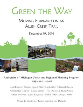
EXECUTIVE SUMMARYGreen the Way
DOWNTOWN
KERRYTOWN/
OLD 4th WARD
WATER HILL
UM CENTRAL
CAMPUS
UM ATHLETIC
FACILITIES
Huron
River
GERMANTOWN
OLD WEST
SIDE
FIRST STREET
BIKEWAY
LINK TO
WEST PARK
LINK TO
DTE SITE
LINK TO
B2B TRAIL
FUTURE SOUTH
EXTENSION
LINK TO
BURNS PARK
TURNTABLE
PARK
ALLEN CREEK
OUTDOOR CLASSROOM
BRIDGE OVER
HURON STREET
GATEWAY
RAIN GARDEN
PARK AT 721 N.
MAIN STREET
FINGERLE
SOUTH
FINGERLE
NORTH
415 WEST
WASHINGTON
227 FELCH
SOUTH
721 N. MAIN
NORTH
Green The Way trail
Park Space and
Rain Gardens
Site Redesign
Opportunity
Legend
Allen Creek Drain
Floodway
Flood Plain
City Park
Railroad
N
0 0.25 0.5 miles
SUMMIT ST.
FELCH ST.
KINGSLEY ST.
CATHERINE ST.
HURON ST.
WASHINGTON ST.
LIBERTY ST.
WILLIAM ST.
JEFFERSON ST.
MADISON ST.
HILL ST.
HOOVER ST.
MAINST.
ASHLEYST.
STADIUM BLVD.
STATEST.
1stST.
MAINST.
BROADW
AY
MILLER AVE.
SegmentSegmentSegmentSegmentAAABACAD
SegmentSegmentSegmentSegmentAAABACAD
Overview of the proposed Green the Way Route
15. 5
This report, Moving Forward on an Allen Creek
Trail, shares routing, design, and phasing
recommendations for a proposed trail in Ann
Arbor, Michigan. The trail, first noted in City’s
planning documents in 1981, follows Allen Creek
from the creek’s source near Michigan Stadium to
the Huron River, and could connect community
destinations while providing attractive green
space and improving stormwater management.
Local leaders and advocates have included an
Allen Creek trail in various City planning efforts,
but a master plan for the project has not been
created. The recommendations in this report are
intended to inform both of these actions, helping
Ann Arbor to move forward with an Allen Creek
trail.
The Green the Way project has been a
collaborative effort between the University of
Michigan’s Taubman College of Architecture
and Urban Planning, the City of Ann Arbor,
and the Allen Creek Greenway Conservancy.
Our team includes 12 Master of Urban Planning
students and two faculty members. In addition
to urban planning, the students belong to
programs in architecture, natural resources and
environment, public policy, and social work. The
team has worked with City staff and Conservancy
members in an effort to produce action-
oriented recommendations that are feasible and
representative of the community’s interests.
While an Allen Creek trail has been included and
discussed in documents for many years, the need
for a comprehensive plan became apparent in
2013 when an application to the Michigan Natural
Resources Trust Fund was denied. The grant
would have helped to transform the City storage
yard at 721 N. Main Street into a park along the
trail. In declining the application, reviewers noted
that the application failed to link the park project
to a larger trail plan. While a disappointment for
trail proponents, the experience highlighted the
value of having a trail master plan, and helped
lead to the Green the Way project.
To create its recommendations, the Green the
Way team followed a three-step process. First,
we reviewed 65 city plans and supplemental
documents about an Allen Creek trail in an
effort to understand the history of the idea and
the current context. Next, the team gathered
community input both in person and through
an online survey. Based on the document
review and community input, the team created
three route options, each of which pursue a
particular goal: minimizing the use of railroad
property; facilitating access to shops, trails, and
other destinations; and maximizing stormwater
management opportunities. We also adapted
a 2008 proposal by the Allen Creek Greenway
Conservancy to create a fourth study route,
which follows the railroad to the Huron River.
1. INTRODUCTION
16. 6
1. INTRODUCTION
Finally, we selected elements from each of the
four study routes — using evaluation criteria
informed by research and community input —
to create a recommended Green the Way Route.
The Green the Way team carefully defined
the scope of our project in order to give
complex issues the attention they deserved. We
intentionally did not consider the potential costs
of our concept routes and Green the Way Route, at
the recommendation of the City. We were told
that City staff are better equipped to calculate
those estimates, and that identifying a route
would need to precede cost estimates. We also
chose to not make specific recommendations for
the three city-owned properties at 721 N. Main
Street, 415 W. Washington Street, and the First
Street and William Street site. Instead, we refer to
the designs that previous planning efforts have
created for these sites.
This report is divided into four additional
chapters. Chapter 2 provides context for the
project, including information on the history
of trail efforts and our summary of previous
documents related to the trail. Chapter 3
describes our community engagement process
and summarizes the input we received. Chapter
4 introduces and analyzes the four study routes
after describing features common to all routes.
Chapter 5 details the Green the Way Route,
proposes phasing for trail development, and
makes recommendations on other next steps.
Appendices to the report contain supplemental
technical and reference material.
17. 7
One of the first tasks undertaken by the Green
the Way team was a document review of previous
work concerning Allen Creek and an Allen Creek
trail. This review increased our familiarity with
the project, informed our understanding of the
motivations behind thetrail, and helpedshape our
approach to trail routing. This chapter reviews
and summarizes the history of the Allen Creek
greenway trail from several planning documents
created by the City of Ann Arbor, previous
University of Michigan master’s projects, and
rails with trails studies, to name a few. These
documents track the evolution of the project
over time, which aided in our identification of
key points for our project. See Appendix A for a
list of the documents reviewed.
History
The first published mention of an Allen Creek
greenway appeared in the City of Ann Arbor’s
1981 Plan for Park, Recreation and Open Space. This
plan recommended developing pathways along
a number of drains through the city, including
Allen Creek. This same plan also recommended
converting a few downtown sites into parks,
including the City-owned site at First Street and
William Street.
The City’s 1988 Downtown Plan connected the
ideas of a pathway along the Allen Creek and
downtown park development, into a single
“greenway” concept (p.54). One of the plan’s
objectives was to “foster the development of a
system of open spaces on the floor of the Allen
Creek Valley” that were “linked by on-street
walkways” (p.54-55). The plan also suggested
that the City-owned properties at First and
William and 415 W. Washington Street could
serve as greenway parks.
An Allen Creek greenway was subsequently
mentioned in the City’s Park, Recreation and
Open Space Plans in 1988, 1994 and 2000. In
2004 the City began to explore an Allen Creek
greenway in earnest, starting with an appointed
Allen Creek Greenway Committee on the Park
Figure 2-1. The City’s 1988 Downtown Plan
identified the City-owned 415 W. Washington
property as a potential greenway park
2. CONTEXT &
BACKGROUND
18. 8
2. CONTEXT & BACKGROUND
Advisory Commission (PAC). This committee
interviewed stakeholders, conducted research,
and ultimately recommended that the City
dedicate three City-owned parcels (721 N. Main
Street, 415 W. Washington, and First and William)
to the greenway. In addition, the committee
recommended that the floodway portion of
each site be dedicated as open space, and the
floodplain portion of each site “be held by the
City for uses in the public interest.” (ACG Task
Force, 2007, p. 13) With this in mind, the City
recognized the flood mitigation potential of a
greenway. The PAC’s Greenway Committee also
recommended a “paved pedestrian/bicycle path
that would roughly parallel the route of the Ann
Arbor railroad tracks” (ACG Task Force, 2007).
While the City contemplated a greenway, citizen
groups also joined in the effort. Groups like
Friends of the Ann Arbor Greenway, the Allen
Creek Greenway Study Group, and later the non-
profit Allen Creek Greenway Conservancy began
investigating and advocating for a greenway
beginning in the mid-2000s.
In 2005 the City took its biggest step towards a
greenway, appointing the Allen Creek Greenway
Task Force to explore a greenway along Allen
Creek. The Task Force focused on how to
develop the three city-owned parcels mentioned
in previous plans. Their work resulted in an
80+ page report with a 650+ page appendix,
completed in 2007. Many hoped that the Task
Force’s report would spark the beginning of work
on a greenway. While the economic recession of
2008 stalled official progress, the Allen Creek
Greenway Conservancy continued their efforts
and proposed a specific route for a greenway that
followed the railroad corridor.
In 2012, a group of master’s students from the
School of Natural Resources and Environment
at the University of Michigan produced a report
that further investigated a greenway along
Allen Creek. Building off the work of the Task
Force and the Conservancy, this student group
investigated where to site a path to form the spine
of a greenway. They followed the Conservancy’s
2008 recommendation to locate the path along
railroad property.
In the years after the Task Force’s report, with
no substantial progress made on a greenway,
the City made efforts to keep the greenway idea
alive. A 2010 City Council resolution expressed a
desire to develop the 415 W. Washington parcel
as a greenway anchor park. The City Council
passed another resolution in 2011 expressing full
support for an Allen Creek greenway.
The City again took concrete steps towards
a greenway in 2013, centered on turning the
decommissioned 721 N. Main Street site into an
anchor park for a greenway. In the early part of
2013, the City secured a FEMA hazard mitigation
Figure 2-2. In 2013, the City applied unsuccessfully for funding to turn the 721 N. Main property into
an anchor park for a greenway trail
19. 9
2. CONTEXT & BACKGROUND
grant to demolish two storage structures at the
721 N. Main Street property. Later that year, the
City applied for a Michigan Natural Resources
Trust Fund (MNRTF) grant to develop the 721
N. Main Street site “as the first part of the Allen
Creek Greenway.” As part of this application,
the City secured $150,000 in matching funds
from Washtenaw County Parks and Recreation
Commission’sConnectingCommunitiesprogram
for the project. The MNRTF grant application
detailed the development of the 721 N. Main
Street site, building off of the work of the City’s
North Main Vision Task Force. The application
also described how the project site and trail
would connect to the existing Border-to-Border
(B2B) Trail network. When the City’s application
was denied, reviewers noted that the City failed
to link the 721 N. Main Street site development
to a larger trail plan. In response, the City and the
Allen Creek Greenway Conservancy decided that
pursuing a comprehensive plan for the greenway
was a necessary step forward.
Past and Present Planning for an Allen
Creek Trail
As part of our research we reviewed 65
documents related to an Allen Creek trail.
These include the City’s Allen Creek Greenway
Task Force Report (2007); Visioning the Allen
Creek Greenway (2012), written by master’s
students in the School of Natural Resources and
Environment at the University of Michigan; Ann
Arbor’s Master Plan, Capital Improvements Plan,
and City Code; additional stormwater, watershed,
and transportation plans; and site assessments
and proposals. While previous proposals have
referred to the project as a “greenway,” we have
adopted the plainer term “trail” in an effort to
reduce confusion. We have divided the content
of these documents into six categories: Trail
Location and Design, Adjacent Properties
and Trail Crossings, Stormwater Management,
Neighborhood Connections and Input, Rails and
Transit, and Funding Opportunities.
Trail Location and Design
The existing approaches for greenway
development can be divided into 1) approaches
that place a greenway trail exclusively along the
railroad corridor and 2) plans advancing the
development of particular sites, especially City-
owned parcels that lie within the Allen Creek
floodway. Despite several past planning efforts,
only the Allen Creek Greenway Conservancy
document Proposed Route of the Allen Creek
Greenway (2008) proposed a specific and detailed
location for the trail. This route followed the
railroad as opposed to the Allen Creek. The
Visioning the Allen Creek Greenway (2012) report
also investigated trail routing, but did not provide
enough detail to be fully considered.
Past plans proposed dividing a trail into
segments and implementing it in phases. The
City’s Downtown Plan (2009) divides a trail based
on the distinctive character of the adjacent areas:
the South Campus Athletic area, the Downtown
commercial/residential area, and the North Main
residential/industrial mix. Visioning the Allen
Creek Greenway (2012) similarly divides a trail into
three segments. The Preliminary Feasibility Study
(2005), created at the University of Michigan’s
Ross School of Business, divides a trail into two
design stages that are contingent on construction
costs and land acquisition within the Ann Arbor
Railroad’s property. The first stage would follow
the railroad from end to end, while the second
stage would deviate from the railroad and cross
over the floodway at the 721 N. Main site, leading
to Wheeler Park and eventually connecting to the
B2B Trail at the DTE site via a new underpass.
Only the Ross report evaluated grading and
construction costs, along with costs associated
with an elevated trail adjacent to the railroad
berm north of Liberty Street.
20. 10
2. CONTEXT & BACKGROUND
The City of Ann Arbor has studied possible
connections between the 721 N. Main Street site
and the B2B Trail, but solutions have proven
difficult. The City submitted a Michigan Natural
Resources Trust Fund Grant Application (2013)
to fund the first part of the trail, but it was
rejected; the grant proposed looped paths at 721
N. Main Street, linking Felch Street, N. Main
Street, and Summit Street and identified several
potential connections to the B2B Trail. The City
also commissioned the Allen Creek Berm: Feasibility
of Flood Reduction and Pedestrian Options (2013)
report, which investigated several initiatives that
could help connect 721 N. Main Street to the
B2B Trail. The study recommends installing two
parallel culverts underneath the railroad berm,
one for the Allen Creek floodway and another
for pedestrians and bicyclists, connecting Depot
Street and the DTE site for an estimated cost of
$3.9 million. In addition to pedestrain and bicycle
links this project could dramatically reduce the
Allen Creek floodplain.
Adjacent Properties and Trail Crossings
According to the Parks & Recreation Open Space
Plan2011-2015,thedowntownareahasashortage
of open space relative to the rest of the city. This
limitsbothrecreationalandstormwatermitigation
opportunities. Incorporating downtown and city-
owned parcels into a greenway trail could help
alleviate these problems.
The City’s Downtown Plan (2009) sets a goal
of reinforcing the stability of the residential
neighborhoods surrounding downtown through
incremental transitions including intermediate-
scale residential development. According to
the Downtown Plan, a greenway could act as an
identifiable boundary between downtown and
adjacent neighborhoods, buffering adjacent uses
with “step-down” development (e.g., medium-
density mixed-income housing). From an
infrastructure improvement point-of-view, the
City’s Non-motorized Transportation Plan (2007, with
update 2013) and the corresponding section of
the Capital Improvements Plan 2014-2019 identify
design principles, funding, and sequencing for
creating safe mid-block non-motorized crossings
that would accommodate trail users and stitch
together neighborhoods across the rail line. The
City has identified railroad crossings at Liberty
Street, Huron Street, and Miller Avenue as
potential major mid-block crossings; Hill Street
and Hoover Street are identified as potential
minor mid-block crossings.
Finally, City plans propose that three city-
owned parcels (415 W. Washington, First and
William, and 721 N. Main Street) serve as major
anchor sites along a trail. Each site has soil
contamination and/or building deterioration
issues. As stated in the Allen Creek Greenway
Task Force’s Report (2007), redevelopment for
an Allen Creek greenway project must consider
additional brownfield mitigation costs.
Stormwater Management
The Allen Creek valley is one of Ann Arbor’s
defining natural features. While the creek is now
enclosedinapipebeneaththeground,itsnorthern
most two miles are significantly impaired, and
those living in this area experience flash flooding
and poor water quality. The Stormwater Model
Calibration and Analysis Preliminary Results and
Recommendations (2014) found the Lower Allen
Creek has the most frequent and severe flooding
in the City. As stated in the Watershed Management
Plan for the Huron River (2011), the Creek’s culverts
and drains are undersized; this often causes
flooding that endangers the 707 properties
within the 100-year floodplain. According to the
Allen Creek Greenway Task Force’s Report (2007)
and the City’s Flood Mitigation Plan (2007), 100%
of National Flood Insurance Program claims
from Ann Arbor have originated from properties
within one quarter mile of Allen Creek. Based
21. 11
2. CONTEXT & BACKGROUND
on water samples, the amount of nutrients
(phosphorus, nitrates, nitrites), suspended solids
(sediment), and pathogens (E. coli) in this water
exceed the City’s new Stormwater Calibration Model
and federal water quality guidelines. Ranked
by the Model as the top area of flood risk and
poor water quality in the City, expanding green
space and integrating the best stormwater
management practices along an Allen Creek trail
would demonstrate Ann Arbor’s commitment to
progressive water management.
Neighborhood Connections and Input
Community engagement directly and indirectly
related to Allen Creek has been going on for
over 10 years through citizen advisory groups,
public meetings, interviews, and surveys. While
individual comments vary, there is broad support
for a greenway. Community engagement is
important in creating an Allen Creek trail because
of the trail’s potential to connect different land
uses, including residential neighborhoods,
commercial centers, parks, and institutional
activities (for example at the University of
Michigan’s athletic facilities). The vision that
emerged from the public input process of the
North Main-Huron River Task Force Report (2013)
was for an Allen Creek corridor that increases
connections between the above destinations,
while being a recreational destination in itself.
The Task Force’s Report (2007) and Visioning the
Allen Creek Greenway (2012) identified two key
neighborhood stakeholders: the Downtown
Development Authority (DDA) and the
University of Michigan. These two stakeholders,
in addition to the City and the owner of the Ann
Arbor Railroad, could benefit from the creation
of a trail along Allen Creek. For the DDA, a
trail would help form a transition between the
residential and commercial areas, while adding
recreational and green space to downtown.
According to the Visioning (2012) report, UM’s
involvement would form “part of the critical
first step” that would make the creation of the
trail viable in Ann Arbor.
Rail and Transit
Trails along rail corridors invariably raise safety
and liability issues for railroad owners. The U.S.
Departmentof Transportation’s(USDOT)report,
Rails-with-Trails: Lessons Learned (2002), found that
accidents between trains and pedestrians are less
frequent when closed fencing separates a trail
from the rail. The Ann Arbor Railroad is a major
thoroughfare for fans traveling to the game on
football Saturdays, posing major liability issues
for the rail owner (WATCO). A designated trail
could help decrease rail trespassing. In addition,
the USDOT report suggests that the liability of
pedestrians using a trail could be shifted to the
City through indemnification agreements, which
could entice WATCO to support the Allen Creek
trail.
Although the Ann Arbor railroad is currently
used for infrequent short-line services (local
line-haul railroads), proposed commuter projects
could increase its use, which will increase the
need for pedestrian safety. The North/South
Figure 2-3. Flooding at Felch Street and Ashley
Street in 2013. The Allen Creek valley sees
frequent floods.
22. 12
2. CONTEXT & BACKGROUND
Commuter Rail (WALLY) project’s evaluation
of downtown Ann Arbor station sites proposes
eight commuter trains daily, connecting Howell
to a proposed downtown station located between
Washington Street and Liberty Street. Meanwhile,
the AAATA is exploring six corridor options for
local transit service known as the Ann Arbor
Connector. One route would follow the railroad
property starting at Madison Street and proceed
south for 1.75 miles, thus complicating the trail’s
potential location within this stretch of the route.
Funding
Constructing an Allen Creek trail would most
likely require a combination of funding sources
that could necessitate phased implementation.
The Allen Creek Greenway Task Force’s Report
(2007) reviewed funding options for a greenway
trail. It suggested that funding requirements
fall into three categories: land acquisition and
easements, park and trail development, and on-
going management and maintenance. Locally,
a source of one time funds could be the
time-limited 2004 Open Space and Parkland
Preservation millage. Commonly known as the
Greenbelt Millage, one-third of these funds
are targeted for land acquisition. Other local
funds might include mitigation funds from new
development or a capital improvement millage.
TheRossSchoolStudy(2005)alsoidentifiedmany
potential funding sources, recommending the
BrownfieldTIFandtheDowntownDevelopment
Authority TIF as the most promising options.
The study also identified numerous funding
sources from the Michigan Department of
Environmental Quality, the U.S. Department
of Housing and Urban Development, the
Federal Emergency Managment Agency, the
Michigan Department of Transportation, and
local government. Many of these are targeted at
watershed improvements, trails, and brownfield
development. Other possible sources of funding
include local foundation support for capital costs,
nonprofit and/or local business support for
operating costs, and Michigan Department of
Natural Resources trail funding. These funding
sources should be revisited due to the time that
has elapsed since the studies were written.
Conclusion
Afterreviewing65cityplansandotherdocuments
concerning an Allen Creek greenway, several key
findings emerge. We determined that only in
the Allen Creek Greenway Conservancy’s 2008
report was a detailed route for the path identified.
In general the approaches for thinking about trail
alignment fall into two categories: exclusively
following the railroad corridor, or deviating
from the railroad in downtown to follow Allen
Creek to the Huron River. In all routes a portion
of a trail will be adjacent to the railroad, which
raises safety and liability concerns. The U.S.
Department of Transportation offers guidelines
that include physical design interventions, such
as fences, and model indemnification agreements
to reduce the railroad’s liability concerns. Several
plans suggest phasing the implementation of
the project, and two plans divide the length
of a trail into three distinct segments: South
Campus/ Stadium, Downtown, and Residential/
Industrial Mix of North Main. Within Ann
Arbor’s Master Plan, the Parks & Recreation Open
Space Plan 2011-2015 noted the shortage of
open space in downtown, and the Downtown Plan
(2009) suggested that a trail could form a needed
buffer between the downtown core and the
residential Old West Side neighborhood. From
a stormwater perspective, the project could
address water quality and quantity problems,
directly and through education. Together, these
issues and plans framed our efforts as we sought
community input and compared potential routes.
23. 13
3. COMMUNITY INPUT
The Green the Way project began with the idea
that an Allen Creek trail cannot be built without
the support and commitment of the Ann Arbor
community. To gauge this support, our first goal
was to talk with residents at public outreach
tables at the Ann Arbor Farmers Market,
YMCA, and the Downtown Library of the Ann
Arbor District Library. We also elicited feedback
through an online survey open to all Ann Arbor
residents to help understand specific areas of
interest and concern. The public outreach tables
and online survey were advertised by posters in
local businesses. To engage the next generation
of trail users, we launched an art competition for
Ann Arbor students.
The Green the Way team was able to dig
deeper into specific issues at meetings with
key stakeholder groups like the Old West Side
Association and the Washtenaw Bicycling and
Walking Coalition. Finally, we concluded our
project by inviting everyone we had engaged
to Green the Way’s public presentation of final
recommendations on December 16, 2014, at
Ann Arbor District Library’s Downtown Library.
In this chapter we document key themes
expressed by community residents, such as safety
on the trail and linkages to neighborhood assets
and existing trails. We used this feedback to help
develop our recommended Green the Way Route
and to incorporate trail features that are intended
to help all users feel safe on the trail. Designing
a trail that Ann Arbor residents want is key to
building a trail that Ann Arbor residents will use.
Public Outreach Tables
Our team used public outreach tables to raise
awareness of the Green the Way project with the
general public in Ann Arbor. Starting in October,
we staffed tables at the Ann Arbor Farmers
Market and YMCA that contained a large map
of the proposed trail, postcards with additional
information, Green the Way buttons, and a sign-
Figure 3-1. Team members Matt and Arthur
staffing our public outreach table at the Ann
Arbor Farmers Market
24. 14
3. COMMUNITY INPUT
up sheet for members of the public to receive
additional updates on the project and online
survey. Green the Way team members engaged
with the public for 34 hours over five days at
the Farmers Market and for four hours over two
days at the YMCA. During this time, we solicited
feedback and answered questions from over 160
people. In addition to our staffed outreach tables,
we set up a standalone information table at the
Downtown Library of the Ann Arbor District
Library.
The Green the Way team gathered feedback at
these public outreach tables on issues like trail
use, safety, and access to destinations. This
feedback helped us define and evaluate different
study routes and trail configurations. The
conversations at these tables also helped us to
identify community and neighborhood groups to
contact.
Key findings from our conversations at
public outreach tables include:
• Ann Arbor residents and visitors expressed
a strong interest in building a trail in this
corridor, especially if it were safe and
comfortable.
◦◦ While the majority of the people we
talked to supported the plan, some
were concerned with implementation,
specifically when the trail would get built,
and how much it would cost.
• The highest interest destinations were
recreational facilities along the Huron
River, especially the Border-to-Border Trail.
◦◦ Residents that lived near the trail were
particularly interested in reaching
downtown.
• The greatest interest in trail use was for
recreation, followed by commuting, dog-
walking, and accessing destinations.
• Some residents and visitors were
particularly excited to have a safe space
to bike with children, along a trail that
would be separated from street traffic. One
resident remarked that a lack of protected
bikeways currently makes Ann Arbor
“starkly different from Madison.”
• Some residents were particularly interested
in providing green space downtown and
highlighting natural features like the Allen
Creek.
◦◦ A few residents hoped to daylight the
creek, opening up storm sewers and
reconstructing the creek.
Survey
The Green the Way team gathered feedback
about trail preferences through an online survey.
In a five-week period, 609 residents responded
with 520 completed surveys. The survey was
open to all members of the public.
To encourage residents to complete the survey,
we distributed posters to over 50 Ann Arbor
businesses to place on windows and community
Figure 3-2. Green the Way’s public outreach
table at the YMCA
25. 15
3. COMMUNITY INPUT
boards. The Green the Way team also placed
posters in university buildings, including the
Michigan Union and the Central Campus
Recreation Building, to encourage students to
participate.
The survey contained seven questions about
the trail and three questions about respondents’
demographics, including years lived in Ann
Arbor, number and age of household members,
and the intersection closest to their home. For
the purposes of analysis, we approximated
respondents’ distance from an Allen Creek
trail using the existing railroad line; as a result,
“distance from trail” is synonymous with
“distance from railroad.” Survey respondents
chose from predefined options for all but one of
the survey questions. In addition to completing
the survey, 182 respondents provided their email
addresses and were invited to Green the Way’s
final presentation. See Appendices B and C for
survey questions and responses.
Most respondents (64 percent) indicated that
they live more than half a mile from the trail.
The specific areas with the highest number of
respondents were, in order: the Old West Side,
Kerrytown, and Burns Park near Packard Street
and E. Stadium Boulevard. Twenty-two percent
of respondents indicated that they live in a
household with at least one child aged fifteen or
younger. At the opposite end of the spectrum,
23 percent of respondents live in households
with at least one person aged 61 or older. The
average respondent had lived in Ann Arbor for
21 years, with a range of three months to 70
years of residence in the City.
A majority of respondents were familiar with
the idea of an Allen Creek trail, with 64 percent
reporting that they are familiar or very familiar
with the project. Some respondents may have
been familiar with an Allen Creek trail only
because of their interactions with us at public
outreach tables and community meetings. We
encouraged both of these groups of people to
take our survey, and the survey did not track
other involvement with Green the Way project
efforts.
The survey sought feedback about three main
items related to the trail: routing, design, and
implementation. This included specific questions
on trail features, such as lighting and artwork.
Other questions focused on preferences relating
to a potential trail—such as concerns about
flooding, willingness to walk farther to avoid
difficult intersections, and individuals’ comfort
level around active railroads.
0 0.25 0.5 miles
N
DOWNTOWN
KERRYTOWN/
OLD 4th WARD
WATER HILL
UM CENTRAL
CAMPUS
Huron
River
GERMANTOWN
OLD WEST
SIDE
UM ATHLETIC
FACILITIES
BURNS PARK
HuronRiver
Rail
Huron River
0
204
Survey Respondents
Per Square Mile
Figure 3-3. Map showing where survey
respondents in Ann Arbor live. Areas in red had
the highest concentration of survey respondents
26. 16
3. COMMUNITY INPUT
Table 3-1. Trail activity frequency by proximity of home to proposed trail (n=609)
Commuting
(%)
Social
activities (%)
Errands or
shopping (%)
Recreation or
exercise (%)
Half mile or less from trail
Daily or several times a week 30 33 38 53
Weekly or monthly 27 59 45 45
Never 43 8 18 2
Total 100 100 100 100
More than half a mile from trail
Daily or several times a week 18 15 11 37
Weekly or monthly 21 68 55 58
Never 61 17 34 5
Total 100 100 100 100
Table 3-2. Trail activity frequency by housing type (n=609)
Commuting
(%)
Social
activities (%)
Errands or
shopping (%)
Recreation or
exercise (%)
All respondents
Daily or several times a week 23 22 21 43
Weekly or monthly 22 65 49 52
Never 55 14 30 5
Total 100 100 100 100
Houses with 1+ senior
Daily or several times a week 13 16 17 40
Weekly or monthly 18 65 51 54
Never 69 18 32 6
Total 100 100 100 100
Families with young children
Daily or several times a week 26 25 27 40
Weekly or monthly 22 61 46 56
Never 53 14 27 4
Total 100 100 100 100
Key findings from the Green the Way Survey:
Most desirable trail activity: recreation or exercise
One of the key questions on trail use asked
respondents to rank the following possible trail
activities: 1) commuting, 2) social activities, 3) shopping
or errands, or 4) recreation or exercise.
Survey respondents most desired to use a trail
for recreation or exercise. Nearly all respondents
reported that they would use the trail for these
purposes at least monthly while, 43 percent
reported that they would use the trail for these
purposes at least several days a week. Social
activities were the second most popular activity,
27. 17
3. COMMUNITY INPUT
with 87 percent of respondents indicating they
would use the trail for this purpose at least
monthly. This was followed closely by errands
and shopping (70 percent). In contrast, 55
percent of respondents reported that they would
never use the trail for commuting.
Recreation/exercise was popular even among
subgroups unlikely to use the trail for other
purposes; for example, 69 percent of households
with at least one senior reported that they would
never commute on the trail, yet 94 percent of
these same households were interested in using
the trail for exercise or recreation. Families
with young children also selected recreation or
exercise as their top choice, followed by social
activities, errands or shopping, and commuting.
While 57 percent of respondents living within
a half mile of the trail indicated they would
commute on the trail at least once per month, that
number dropped to 39 percent of respondents
who live more than a half mile from the proposed
trail. Instead of commuting, respondents living
farther from the trail indicated a preference
for recreation or exercise (95 percent), social
activities (83 percent) and errands or shopping
(66 percent). These findings suggest that people
who live farther from the proposed trail see the
trail as an opportunity to create a recreational
amenity in downtown Ann Arbor.
Strong Support for Six Destinations
Respondents rated their desire to reach 10
different destinations along the trail. In order
of popularity — based on the percentage of
respondents who rated them “important” or
“very important” — these destinations are:
• Border-to-Border Trail
• Argo Livery
• Bluffs Nature Area
• West Park
• Ann Arbor Farmers Market
• YMCA
• Michigan Stadium
• Washtenaw Dairy
• Bill’s Beer Garden
• Blank Slate Creamery
Over 50 percent of respondents selected the
top six destinations. In addition to the 10 pre-
defined destinations in the survey, respondents
Huron
River
Less Important
Legend
Allen Creek Drain
Floodway
Flood Plain
City Park
Railroad
N
0 0.25 0.5 miles
More Important
Number of Survey
Respondents
SUMMIT ST.
FELCH ST.
KINGSLEY ST.
CATHERINE ST.
HURON ST.
WASHINGTON ST.
LIBERTY ST.
WILLIAM ST.
JEFFERSON ST.
MADISON ST.
HILL ST.
HOOVER ST.
MAINST.
ASHLEYST.
STADIUM BLVD.
STATEST.
1stST.
MAINST.
BROADW
AY
MILLER AVE.
Bluffs Nature Area
Argo Livery
Border-to-Border Trail
Farmer’s Market
West Park
Blank Slate Creamery Bill’s Beer Garden
Michigan Stadium
Washtenaw Dairy
YMCA
367
448 480
338
353
157
273
206
212
228
Important Trail
Destinations to
Survey Respondents
228
Figure 3-4. Map showing survey respondents’
important destinations that should be linked to
an Allen Creek trail
.
28. 18
3. COMMUNITY INPUT
were able to to state additional locations in an
“other” category. Locations identified included
downtown (eight mentions), other parks (six
respondents identified Bandemer Park), Argus
Farm Stop (six mentions), the Huron River
(five mentions), and the Amtrak station (four
mentions). Please refer to Appendices D, E, and
F for a full list of open-ended survey responses.
Important Trail Functions
Flood mitigation emerged as an important or
very important trail feature among 89 percent
of respondents. Both respondents living within
a half mile of the proposed trail and those
living farther away reported strong support
for flood mitigation, with 91 percent and 89
percent, respectively, rating this trail function as
“important” or “very important”. This finding
suggests that awareness of flooding and support
for flood mitigation extends far beyond the
immediate Allen Creek area.
Support for public artwork was notably lower
than other trail features. Residents living close to
the trail were the strongest supporters of public
artwork, with 54 percent voicing support for this
feature compared to 36 percent of respondents
living farther away. This finding suggests
that people living close to the trail are more
concerned with the trail’s appearance compared
to more distant residents. Responses from the
open-ended portion also echoed the need for
beautification measures like greenery and natural
landscaping.
Other observations
• For the majority of respondents, creating
a trail next to the railroad was not a
safety concern. More than 90 percent of
respondents said that they are comfortable
using a trail next to an active railroad.
• There is broad awareness of flooding.
Seventy-seven percent of respondents
believe that flooding is a problem in Ann
Arbor.
• Ninety-six percent of residents want Huron
River water quality to be improved.
• Three-quarters of respondents reported
that they have walked or biked longer
routes to avoid difficult intersections.
Survey respondents gave a fair amount of
feedback on the open comment portion at the
end of the survey. A total of 181 respondents
took the time to write a comment and four major
themes emerged:
General support: Many respondents were in
support of the project, leaving comments like
“great idea!” and “Don’t give up. This will
take a lot of effort over the years.”
Action: Many respondents noted how eager they
were for trail construction to begin. Comments
included: “Do something already!” and “I’d
like to see this in my lifetime!”
Daylighting: Although our research made it clear
that daylighting the Allen Creek is not currently a
viable option, some respondents were interested
in making it part of the trail project. Specific
comments urged plans to “Bring Allen Creek
back to the surface. There must be a way.”
Trail separation: Many respondents want the
proposed trail to separate bicycle riders from
other trail users. One respondent noted: “Make
it WIDE and put a painted divider line to
encourage separation of high speed from
lowspeed traffic. E.g., cyclist, joggers,
rollerbladers from walkers and families with
children.”
Although the overall sentiment from survey
respondents about the trail was positive, not all
respondents were supportive. A few respondents
expressed doubt about the viability of the project,
questioning the wisdom of building a trail next to
29. 19
3. COMMUNITY INPUT
an active railroad. Another respondent suggested
that the City should “fix the infrastructure
first.” Thus, some respondents feel that it is not
worthwhile to construct a trail without assuring
trail quality or addressing infrastructure needs.
Finally, we would like to acknowledge potential
limitations with our survey. Although we
received many completed surveys, these results
should not be taken to represent the views of the
entire Ann Arbor community. Sixty-four percent
of survey respondents were already familiar or
very familiar with the trail. The the majority of
survey respondents also lived close to downtown.
Because the survey was only available online, the
results exclude the opinions of those without
Internet access or those unwilling to use the
Internet.
Art Competition
Youth are frequently excluded from traditional
planning processes. In an effort to include them,
we launched a youth public art ideas competition.
With sponsorship from the Dow Sustainability
Fellows Program, we had $5,000 to cover prizes
and expenses.
In collaboration with the Allen Creek Greenway
Conservancy, the Green the Way Student
Art Ideas Competition encouraged students
to integrate sustainability and environmental
awareness into an Allen Creek trail by designing
artwork that could complement the greenway.
The competition was open to all students in
Washtenaw County, grades 6-12. Students were
asked to submit a unique works of art that could
be replicated and placed at various points along
the trail to mark its path.
The Green the Way project enlisted help of the
AnnArborPublicSchoolartteacherstoshapethe
call for submission and ensure that we engaged
youth in a meaningful way. Award amounts were
substantial with a first-place prize of $1,500, a
second-place prize of $1’000 and a third-place
prize of $500. Fourteen schools participated in
the competition. The entries will be displayed in
Ann Arbor and a jury will select the winners in
January, 2015.
Community Meetings
We prioritized face-to-face meetings with
community groups. These meetings helped to
gather suggestions from residents and hear their
concerns. At each meeting we asked residents
to specify how they would use the trail, identify
key local connections and safety considerations,
and document additional route suggestions or
concerns.
The Green the Way team reached out to 11
neighborhood groups who are geographically
Figure 3-5. Green the Way team member Luke
facilitates a community meeting
30. 20
3. COMMUNITY INPUT
close to the proposed trail and two advocacy
groups representing possible key users of the
trail. We attended seven community group
meetings, with 65 total residents. These groups
were:
• Washtenaw Biking and Walking Coalition
(board meeting and general meeting);
• Sierra Club, Huron Valley Group, Michigan
Chapter;
• North Central Neighborhood Association;
• Old West Side Association and Near West
Side neighborhood (combined meeting);
• Water Hill neighborhood; and
• Germantown Neighborhood Association.
Any groups that were not able to meet with the
Green the Way team were invited to provide their
feedback through e-mail, the online survey, and
attending the public presentation.
Additionally, the current council members
for Wards 1, 4, and 5 were informed of the
community meetings in their wards and invited
to attend. All 10 council members were invited
to attend the public presentation.
A few common themes emerged from our
meetings with community members:
Safety was a common topic of discussion for
community groups, including both personal
safety and traffic safety. Personal safety concerns,
which relate to fear of crime, included a desire
for adequate lighting for evening use and a
desire for an active and lively trail environment.
Traffic safety concerns, which relate to avoiding
crashes, included a desire for safety from cars at
intersections and railroad crossings, as well as
separation between bicyclists and pedestrians.
Desired links to different amenities was also
discussed often in these sessions. Residents
wanted the proposed trail to connect to
destinations in Ann Arbor and serve as a
recreational tool to get to certain destinations.
These potential links included:
• Downtown area businesses;
• Other parks and trails (B2B trail, Argo
Canoe Livery); and
• Briarwood Mall.
Much of the information gathered in these
meetings closely mirrored our survey results,
especially in terms of trail safety and destinations.
Additionally, in each community meeting
participantswereaskedtodrawtheirdesiredroute
for the proposed trail on a map of Ann Arbor.
This collaborative mapping exercise garnered
fruitful discussions about nearby amenities and
how the proposed trail could benefit their daily
lives and activities. Figure 3-7 is an aggregate
map that combines all the community maps
gathered in our meetings. The map indicates that
many community members are familiar with the
railroad as a primary routing option; few maps
depicted routes that strayed far from the railroad.
The most variation in participants’ maps is seen
in the northern section of the trail, where the
Figure 3-6. Washtenaw Biking and Walking
Coalition members use maps to draw potential
routes and identify important destinations
32. 22
3. COMMUNITY INPUT
Green the Way team had previously identified
various routing options. This is especially true
for a connection to the B2B Trail, where no
consensus is evident on participants’ maps. A
number of participants also drew connections to
West Park and down Liberty Street.
During the course of our community meetings,
we found that residents of Ann Arbor were
generally eager and excited about the prospect
of an Allen Creek trail. Residents who had
used urban trails in other cities were especially
enthusiastic about about developing a similar
trail in Ann Arbor.
Summary of Community Input
Our methods of community engagement allowed
us to collect different types of input from a
variety of community members. Nonetheless,
a few themes emerged. Community members
want:
• Recreational opportunities prioritized above
commuter uses
• Stormwater and water quality issues
addressed in the Allen Creek valley
• Safety prioritized along the trail. This
encompasses different dimensions of
safety: personal safety, safety from cars at
crossings, safety at night, safety from fast
moving bicyclists or other users
• Local destinations and amenities linked to
the trail, especially those at the northern
end of the trail
While we tried to be as inclusive and
comprehensive as possible in our community
engagement, our efforts were not without
limitations. Table 3 summarizes some of the
strengths and limitations of our community
engagement efforts.
The wide-ranging community collected provides
a solid base upon which we have built the trail
features, study routes, and our recommended
Green the Way Route, described in the following
two chapters of this report. We recommend
that future public engagement be targeted to
solve more specific challenges in designing
and implementing a trail. Please see Chapter 5
for recommendations about future community
engagement.
Table 3-3. Strengths and weaknesses of community input process
Strengths Limitations
Open process with multiple ways for residents
to share their opinions
Narrow time frame from September to
December 2014
Over 600 Ann Arbor residents responded to
online survey
Online survey is only accessible to users with
internet access
Community meetings provided a forum to
better understand concerns raised in survey
Self-selection: participants who attended
were more knowledgeable than the general
community
33. 23
4. TRAIL FEATURES
& DESIGN
After describing trail features that are common
to all routes, this chapter introduces and
compares four study routes. In specifying these
features and study routes, the Green the Way
team used insights gained from previous studies
and documents, as reported in Chapter 2, and
community input, as reported in Chapter 3. The
ideas and route evaluations contained in this
chapter informed the recommended Green the
Way Route that we describe in Chapter 5.
TRAIL FEATURES
As part of our route analysis we identified features that would be common to all routes. These
trail features include gateway parks, design elements, railroad considerations, road and sidewalk
crossings, and personal safety infrastructure.
Gateway Parks
While there would be many places to access an Allen Creek trail, gateways are unique spaces that
orient users to the trail, Allen Creek, and Ann Arbor, and accommodate activities and users
beyond dedicated trail use.
Figure 4-1. The Green the Way team studying route options
34. 24
4. TRAIL FEATURES
North Gateway
The city property at 721 N. Main Street
would mark the northern edge of the
trail. In the short term this property
would include a small parking area,
bicycle racks, a trail map and educational
signage about Allen Creek. Long term,
the park would include extensive rain
gardens and stormwater infrastructure.
There would also be demonstration areas
with examples of native vegetation and
“yard-type” rain gardens. This location
would benefit from public restrooms
and a small maintenance area.
We propose a short-term connection
to the existing Border-to-Border Trail
over the Broadway Bridge, following
a path from 721 N. Main along E.
Summit Street through Wheeler Park.
Long-term plans could include a direct
connection, for example through the
proposed tunnel under the railroad
berm or using a new bridge over N.
Main Street. For further detail, see
“North Extension and Connection to
the Huron River” in Chapter 5.
Downtown Gateway
The City-owned property at First Street
and William Street, currently used as a surface parking lot, would mark the downtown anchor
of the trail. In the short term this area would contain rain gardens, bicycle racks, a trail map,
and educational signage about Allen Creek. Long-term this area would be a gathering point
for a network of downtown trails, and include an outdoor classroom with interactive exhibits
about water flow in Allen Creek.
South Gateway
The southern boundary of the trail would occur where the railroad crosses S. State Street,
near the intersection of S. State Street and Stimson Street. There are no City properties or
Figure 4-2. Gateway parks, rail considerations,
and road and sidewalk crossings
DOWNTOWN
KERRYTOWN/
OLD 4th WARD
WATER HILL
UM CENTRAL
CAMPUS
UM ATHLETIC
FACILITIES
Huron
River
GERMANTOWNOLD WEST
SIDE
Gateways
Road &Sidewalk
Crossings
Legend
Allen Creek Drain
Floodway
Flood Plain
City Park
Railroad
N
0 0.25 0.5 milesRailroad on Berm
Trail Features
SUMMIT ST.
FELCH ST.
KINGSLEY ST.
CATHERINE ST.
HURON ST.
WASHINGTON ST.
LIBERTY ST.
WILLIAM ST.
JEFFERSON ST.
MADISON ST.
HILL ST.
HOOVER ST.
MAINST.
ASHLEYST.
STADIUM BLVD.
STATEST.
1stST.
MAINST.
BROADW
AY
MILLER AVE.
35. 25
4. TRAIL FEATURES
undeveloped parcels in the immediate vicinity to provide a clear south gateway. At a minimum,
the southern gateway should include bicycle racks, car parking, open space for rain gardens,
and trail signage with a map and information on Allen Creek.
Ann Arbor residents indicated that the trail should make connections to the south, including
to the Briarwood Mall area and Ann Arbor Airport. We recommend that future work on an
Allen Creek trail consider these southern extensions, along with connections to existing trails
and parks along E. Stadium Boulevard and Washtenaw Avenue. For further detail, see “South
Extension to Pittsfield Township” in Chapter 5.
Design Elements
The basic features of a trail are surface, signage, and rain gardens. Many of these features have
well-established standards, and any recommendations here would be updated to match Ann
Arbor and Washtenaw County standards when construction begins. Further, specific details
are best handled during the landscape design phases of construction.
Trail Specifications
Width. At a minimum the path would be 10 feet wide with 2 feet wide shoulders, creating a
14 foot wide trail. In most locations the “greenway” characteristics of the trail, rain gardens,
green open space, and activity areas, will extend beyond the 14 foot trail width. Further, at
locations with high user volumes or complex merging of different types of users, the trail
should be wider if possible. This could happen near Michigan Stadium, or at the “gateways”.
Surface, Striping, and Markings.
The surface of the trail would be asphalt or concrete in a limited number of locations. The
mix and trail surface should be chosen with year-round maintenance and heavy use in mind.
The high water table in the Allen Creek floodway means that pervious surfaces are not
recommended; during rain events it is possible
that water could rise through the surface,
which is detrimental to the trail and stormwater
management. Run-off from the trail would be
handled through rain gardens.
The majority of the trail would be striped with
two lanes, separating two-way traffic and creating
passing zones for users traveling at different
speeds (see Figure 4-3). The striping material
should be reflective, increasing its visibility
during the early morning and evening.
Figure 4-3. Two-lane path striping
36. 26
4. TRAIL FEATURES
There are a number of different markings that
could be applied to the trail surface: distance
and mile markers; traffic and safety directions
at intersections; branding graphics; and active
children’s games (see Figure 4-4). Markings
should be coordinated with other forms of
signage and can help create an active trail
by engaging the surface of the trail itself in
telling the story of Allen Creek or Ann Arbor.
However, all marking should be clear and
consistent, adding to wayfinding along the trail.
While trail sections are being constructed,
temporary connections on city sidewalks and
streets will be required. Consistent markings
applied to these temporary routes could create a
continuous route before trail completion.
Signage
Signage is one of the most important aspects of a well-defined trail. Creating an identifiable
trail logo, and coordinating colors, fonts, map, and diagram styles, would help users recognize
the trail and follow it. The types of signage that would be part of the trail include:
• User safety, including traffic signs, warnings
at railroad and road crossings
• User guidelines
• Wayfinding, including maps and directional
signposts for neighborhood destinations
• Education, including information about
Allen Creek, stormwater management, Ann
Arbor history, and neighborhood assets
• Public engagement, featuring signs to
encourage physical activity, mark special
events, and include public art
Rain Gardens
An Allen Creek trail would be as much a piece of stormwater management infrastructure as
it would be a trail. Rain gardens handling trail and adjacent surface runoff in order to help
mitgate flooding issues in the floodway are as integral to trail design as the trail itself.
Figure 4-4. Safety, traffic, and mile
markers on trail surfaces
Figure 4-5. Trail signs and logos
37. 27
4. TRAIL FEATURES
Rain Gardens are shallow detention areas that
store stormwater during small storms or handle
overflow during large rain events. Best planted
with deep-rooted plants, they are adaptable to
linear locations, adjacent to sidewalks and roads,
wider trail side areas, and large yards and fields.
There are rain gardens in Ann Arbor along Miller
Avenue and at the YMCA similar to those that
would be installed along a trail or at the gateway
parks (see Figures 4-6 and 4-7).
Railroad Considerations
Rail-with-trail projects are well-established.
Three key concepts describe how active railroads
interact with trails: buffer space separating rail
from trail, physical barriers, and rail crossings. The recommended buffer widths and barrier
types vary based on railroad traffic and right-of-way widths. (The railroad property which
surrounds the railroad tracks is also referred to as railroad right-of-way. This report uses the
two terms interchangeably.) Trail crossings also require special attention.
Buffer Space
Michigan Department of Transportation (MDOT) rail standards identify a space 8.5 feet from
the center of railroad tracks as the “minimum clear space,” where no “bridges, structures,
poles, or obstructions” can be located (MDOT, n.d.). Similarly, the Federal Highway
Administration’s Manual on Uniform Traffic
Control Devices recommends a six-foot “dynamic
envelope” measured outward from each rail,
which is equivalent to 8.5 feet from the center
of the tracks (FHWA, p. 767). This space allows
for overhang from freight cars and the natural
“wobble” that occurs as trains move. The study
routes presented later in this chapter each exceed
this minimum separation distance even at the
narrowest clearance points between rail and
trail, including space for a barrier and additional
room between the barrier and trail surface.
Figure 4-6. Small rain garden at Miller
Avenue
Figure 4-7. Large swale at the Ann
Arbor YMCA
38. 28
4. TRAIL FEATURES
Physical Barriers
Proper barriers, such as ornamental iron picket
fences and chain link fences, deter trespassing
on railroad tracks (FHWA, 2002). Ornamental
iron picket fences are more difficult to climb
and vandalize, but are also more expensive. Any
fence that divides the rail from the trail would
be at least six feet high (See Figure 4-8).
Fencing would be installed south of Hill Street
where trespassing occurs frequently on football
game days. The fencing would help contain
foot traffic to a safe and designated area. In
general, fencing would be installed whenever
the rail is relatively level with the trail (south of
Washington Street), and especially on segments where the railroad property is narrow, such as
between Hill Street and Madison Street.
While fencing helps to prevent pedestrians from interfering with rail operations, it could be
impractical at locations where the rail crosses closely-spaced streets. The railroad occupies
small triangles of land adjacent to many downtown crossings such as William Street and
Liberty Street. These areas would not be fenced. Also, fencing would not be required where
the path runs next to elevated railroad segments with steep side slopes. This is the case from
Washington Street northward.
Rail Crossings
Most study routes suggest east-west track crossings mid-block on Hill Street and/or Hoover
Street. In these locations, the trail would cross the tracks perpendicularly using existing or
Figure 4-8. Mission City Bike Trail
next to Metrolink commuter rail line,
San Fernando, CA
Figure 4-9. Crossing gates
installed beyond sidewalk
edge to block sidewalk and
road, Ft. Collins, CO
Figure 4-10. Fencing and
crossing gates at rail/trail
crossing, Irvine, CA
Crossing Gates
Currently, there
are no road or
sidewalk gates at
railroad crossings
in downtown Ann
Arbor. Increased
pedestrian and
bicycle traffic may
require upgrades.
TRAIL FEATURES
39. 29
4. TRAIL FEATURES
expanded sidewalks. The mid-block street crossing would follow the guidelines described in
the paragraphs that follow. Additionally, a crosswalk beacon may be appropriate and crossing
gates spanning both the street and sidewalk could be used to guard the railroad crossing itself.
Road and Sidewalk Crossings
A trail through the central area of Ann Arbor
would require road and sidewalk crossings. A
greenway presents an opportunity to prioritize
anddesignthesecrossingstosafelyaccommodate
all users. Many crossings along these routes fall
into typical crossing types based on their common
features. At a few specific road and sidewalk crossings,
common to many routes, current conditions
pose special challenges.
Typical Crossing Types
Stop Sign Intersections- When any of our study
routes encounters a stop sign, generally the
route makes a sharp, right-angle turn at the same
intersection. Thus, pedestrians and bicyclists would cross a street at a crosswalk and immediately
turn to either continue on the trail or cross another street. This type of intersection presents
two challenges. First, providing safety from cars; and second, allocating sufficient space for
bicyclists to maneuver without blocking other
trail users.
We propose narrowing the road at stop sign
intersections and expanding the sidewalk,
giving bicyclists and pedestrians more space.
Additionally the intersection and crosswalks
should include lighting for nighttime visibility,
pavement markings, and signage to increase the
visibility of the trail and its users (see Figure
4-11).
Mid-block Crossings- This report describes
locations drivers do not expect to stop, either
between intersections or at intersections where
the larger street does not stop, as mid-block
crossings. To make mid-block crossings as safe
Figure 4-11. Enhanced stop sign
intersection along Indianapolis
Cultural Trail, featuring high-visibility
crosswalks and corner bump-outs
TRAIL FEATURES
Figure 4-12. A rendering of a speed
table, a design solution to increase
safety where the trail crosses streets
mid-block
40. 30
4. TRAIL FEATURES
as possible, we propose using widened and raised crosswalks, otherwise known as speed tables.
At a speed table the road is raised where the trail crossing occurs and for a short distance
ahead and behind it (see Figure 4-12). Speed tables slow cars down and eliminate grade change
in the trail by keeping it at curb and sidewalk height. We also recommend that speed tables be
accompanied by curb-bump outs to reduce the street crossing distance, along with lighting to
increase visibility at night. In some locations, it may be too difficult to design speed tables that
also accommodate stormwater drainage. In those
cases as well as in higher traffic areas, flashing
crossing beacons could be considered.
Specific Road and Sidewalk Crossings
First Street and Liberty Street
At the intersection of First Street and Liberty
Street the trail would connect from the
Downtown Gateway, otherwise known as the
Allen Creek Outdoor Classroom, to the 415 W.
Washington Street parcel. This would require
two crossings of busy streets (See Figure 4-13).
The crosswalk across First Street is the longest
in the proposed route, exposing pedestrians and
bicyclists to traffic for a longer period of time.
The sidewalks around the intersection are narrow,
providing little room to accommodate trail users.
Driveways into Blank Slate Creamery and 305
W. Liberty (Liberty Lofts Annex) create conflict
points for cars and sidewalk users. The railroad
tracks also cut through the southwest corner of
the intersection, limiting the amount of space for
crossing.
In the short term, we suggest that the trail follow
existing crosswalks on the south and west sides
of the intersection. This solution would involve
widening sidewalks, using bump-outs, and
increasing trail visibility. In the long term, this
could be an intersection where grade separation
is explored.
TRAIL FEATURES
Figure 4-13. First Street and Liberty
Street intersection
Figure 4-14. First Street and William
Street intersection
41. 31
4. TRAIL FEATURES
First Street and William Street
The intersection of First Street and William
Street presents similar challenges to the
intersection at Liberty Street. The railroad tracks
cross William mid-block at an angle, and limit
the amount of space around the intersection.
Furthermore, the tracks would have to be crossed
to reach the proposed Downtown Gateway park.
We suggest routing a trail through the triangular
parcelof railroadpropertyonthenortheastcorner
of First and W. William in order to bridge the
connection from the trail south of William to the
Downtown Gateway park (See Figure 4-14).
This allows the trail to cross W. William and the
railroad tracks at a right angle, which is ideal for
safe crossings.
S. Main Street and Madison Street
The trail approaches Madison Street close to
where the street intersects with S. Main Street,
requiring two crossings in a short distance. The
crossings are complicated by the fact that S.
Main is wide with heavy traffic flow and narrow
sidewalks. The City’s Non-motorized Transportation
Plan Update recommends that S. Main be
converted from two lanes in each direction to
one lane in each direction, plus a center turn
lane, and on-road bike lanes (Ann Arbor, 2013,
p. 178-179). The reconfiguration would be an
opportunity to allocate some road space to
make it easier for trail users as well as on-road
bicyclists to traverse this intersection.
We propose crossing the intersection using the
south and west crosswalks. This represents the
Figure 4-16. Merge of on-road bicycle
lane with side path
TRAIL FEATURES
Figure 4-15. Main Street and Madison
Street intersection
42. 32
4. TRAIL FEATURES
Figure 4-17. Trail emergency call light
or blue light
safest way to move trail users from one corner of
the intersection to the other, with a minimum of
right-angle turns. This crossing will be improved
when the City’s Non-motorized Transportation Plan
recommendations are implemented. At that
point it may be possible to widen the S. Main
Street sidewalks, providing extra space for trail
users. One potential option to explore is for the
new bike lanes to merge up onto the curb and
into the trail, similar to how bicycle lanes merge
on and off the sidewalk on Nixon Road (See
Figure 4-15).
Personal Safety Infrastructure
Personal safety was a recurring theme in
community meetings, at the public outreach
tables, and in survey responses. In addition to
the traffic safety measures previously noted,
we recommend incorporating specific elements
to increase personal safety and evening use of
the trail. The trail should be well lit at night,
particularly in narrow and constrained sections.
Additionally, blue lights with police call buttons
could be distributed along the route (See Figure
4-17). The route itself should have frequent and
well-defined entry and exit points.
TRAIL FEATURES
43. 33
4. TRAIL DESIGN
THE STUDY ROUTES
Our analysis of previous plans and documents
revealed a range of motivations for an Allen
Creek trail. These include facilitating recreational
andcommuteruse,connectingneighborhoodand
downtown destinations, mitigating stormwater
and flooding issues around Allen Creek, and
increasing green space in downtown Ann
Arbor. Additionally, the documents show two
approaches for aligning a trail, either following
the historic creek bed or the railroad.
To explore the trade-offs between these interests
the Green the Way team specified four study
routes and compared their differences:
The 2008 Essential Route would provide a
basic route along the railroad. This study
route is based on a proposal developed by
the Allen Creek Greenway Conservancy.
The Minimal Rail Route would follow the
railroad while minimizing use of railroad
private property.
The Connections Route would focus on non-
motorized travel to destinations between
the Huron River, downtown and the south
end of the University of Michigan athletic
campus, connecting users to identified
destinations.
The Stormwater Route would prioritize
stormwater and flooding issues in the
Allen Creek valley. This route deviates
from the rail corridor near Kingsley Street
and follows the Allen Creek floodway to
the Huron River.
Evaluating Routes
We developed a list of evaluation criteria based on
the various motivations articulated for an Allen
Creek trail. These criteria allow us to compare
how well the different routes would perform.
Evaluation Criteria
Stormwater
• Improve water flow in the Allen Creek
valley
• Incorporate rain gardens and other
stormwater infrastructure
• Foster public awareness of Allen Creek
and the environmental challenges in
urban watersheds
Commuting
• Create a protected trail environment for
bicyclists and pedestrians
• Create a continuous travel experience by
minimizing crossings
Community Resources
• Provide bicycling and walking
connections to residential neighborhoods
• Highlight historic features of nearby
neighborhoods or natural environments
Safety
• Minimize secluded areas and provides
trail users with visibility into their
surroundings
• Minimize mid-block and non-
perpendicular pedestrian and bicycle
crossings of roads and railroad
• Minimize railroad crossings
Feasibility
• Minimize structure removal
• Minimize property acquisition
• Minimize linear feet of easements on
non-railroad private property
• Minimize linear feet on railroad property
46. 36
4. TRAIL DESIGN
In order to apply the criteria, we developed
qualitative and quantitative descriptions for each
route. For qualitative analysis, each route has a
set of goals and a brief description of the trail
as it proceeds through the city. The quantitative
analysis provides a set of common metrics for
each route. These metrics include: length of
the proposed trail, with breakdowns into length
on city, railroad, University of Michigan and
other private property; number of railroad and
street crossings; number of parcels requiring
easements; and number of structures identified
for removal.
ROUTE GOALS
2008 Essential Route
Adapted from the Allen Creek Greenway
Conservancy’s Proposed Route of the Allen Creek
Greenway: Essentail Route and Future Opportunities;
January 2008 Draft
Goals
• Create a continuous trail route adjacent to
railroad property
• Identify railroad and other private property
along the route requiring easements
• Establish a rationale for a downtown
greenway park at 415 W. Washington Street
The 2008 Essential Route would largely run within
railroad property, and create a direct north-south
connection from the Huron River to the railroad
crossing at S. State Street. The route identifies
parcels and property owners adjacent to and in
the path of the route. Note: the Green the Way
team inferred the goals listed above from the
route’s path and accompanying descriptions; the
goals were not explicitly listed in the documents
we reviewed.
Advantages
The 2008 Essential Route would:
• Create a direct and legible route
• Propose property acquisitions and structure
demolition that could improve water flow
in the Allen Creek valley
• Link to existing walking and cycling routes,
including the bicycle lanes on E. Stadium
Boulevard and the Border-to-Border Trail
• Address issues surrounding development
in the floodplain and floodway by
recommending parks and open space
Limitations
The 2008 Essential Route would:
• Require negotiating many property
easements with the railroad and other
private property owners
• Increase cost by relying more on property
easements and acquisitions relative to the
other study routes
• Require further development to assess
the safety of pedestrian, bicycle, car and
railroad crossings at many locations along
the route
Figure 4-19. The Allen Creek Greenway
Conservancy proposed this wide section of
railroad property be used as a park featuring a
historic railroad turntable
47. 37
4. TRAIL DESIGN
• Require a clear and feasible solution for the
acknowledged challenge of crossing the
railroad berm separating the northern trail
segment from the Huron River
• Recommend construction of significant
new infrastructure elements, mainly bridges,
that may require phasing
Minimal Rail Route
Goals
• Maximize distance between the route and
railroad-owned property
• Control the interface between rail and route
The Minimal Rail Route is designed to minimize
interaction between a trail and the railroad.
In some areas, rail-trail crossings and railroad
property easements are difficult to avoid without
jeopardizing the continuity and feasibility of
the trail. Avoiding railroad property requires
easements on property located next to the
railroad property. It also requires engaging with
the University of Michigan and the City of Ann
Arbor, owners of approximately 60 percent
of the property within this route. With willing
partners, the Minimal Rail Route would only
require railroad easements along 12 percent of
its length.
The Minimal Rail Route acknowledges that the
rail corridor is active and may see new passenger
service in the future. Trains currently travel along
these tracks at a maximum speed of five miles
per hour; still, it is important to separate the
route from the rail with a barrier of some kind
(FHWA, 2002, p. 52). The Minimal Rail Route
would control the interface between the railroad
and trail users through signage and pedestrian
crossing treatments at rail intersections, and by
minimizing rail-trail crossings.
Advantages
The Minimal Rail Route would:
• Avoid railroad property except for 1,600
feet of trail at five pinch points where there
is no other feasible option
• Promote safe travel along the trail by
minimizing the danger of pedestrians
walking out onto the rail
• Respect railroad operations by exceeding
the minimum required separation distance
between the rail and trail
Limitations
The Minimal Rail Route would:
• Cross several private properties and a
considerable amount of UM property on
the south end of campus
• Rely on private property easements outside
of railroad property
• Require removal of a number of private
parking spaces within potential trail
easements
Figure 4-20. Path serving different types of
users in Madison, WI
48. 38
4. TRAIL DESIGN
Connections Route
Goals
• Prioritize safety at crossings and along the
route
• Minimize distance and time of reaching
destinations
• Connect directly to destinations identified
by the community
• Support different users by splitting the
route into an east branch and a west
branch, designed specifically for bicyclists
and pedestrians
The Connections Route would emphasize continuity,
trail environment, and directness. Continuity minimizes
interruptions of the trail and abrupt turns. Trail
environment stresses the presence of greenery
along the trail and separates high-speed or
high-volume vehicular traffic from trail users.
Directness minimizes the distance traveled between
destinations, it would be provided by a split in the
route. Starting at First Street and William Street,
trail users heading north could choose to follow
an east branch of the trail that travels along
First Street. This branch would provide separate
spaces for bicyclists and pedestrians and would
be the most direct route for trail users wanting
to travel north or south. Alternatively, trail
users could follow a west branch that provides
a quieter and greener trail experience. The west
and east branches would rejoin at First Street and
Miller Street.
The Connections Route also would prioritize
safety by using active and well-lit streets, and by
improving crossings. The branches would present
trail users with choices, including the option to
travel in a loop on exercise and recreational trips.
Overall, the trail would offer bicyclists, runners,
dog-walkers, and other route users, including
those with limited mobility, with a safe and clear
route to a wide range of destinations.
Advantages
The Connections Route would:
• Create a comfortable, landscaped trail
environment, anchored by small parks
• Provide trail users with direct north-south
access to downtown
• Improve traffic safety along First Street
by separating car, bicycle, and pedestrian
traffic and by giving bicyclists and
pedestrians a dedicated green light at
intersections
• Allow for rain gardens between separated
lanes for cars, bicyclists, and pedestrians
• Connect to West Park, creating a link for
recreational users and connecting to West
Park’s stormwater infrastructure
Limitations
The Connections Route would:
• Require multiple property easements and
acquisitions to fully implement the route
Figure 4-21. Protected bicycle lanes, like this
one on Delaware Avenue in Philadelphia, can
provide separate spaces for bicyclists and
pedestrians
49. 39
4. TRAIL DESIGN
• Cross five driveways, including two public
parking facility entry/exit points to public
parking facilities, along the east branch
• Require removal of 10 on-street parking
spaces and two loading zone spaces along
the east branch
• Require wayfinding signs to help trail users
navigate the west branch and east branch
• Lessen personal safety along the west
branch, which is comparatively isolated and
would see fewer trail users than a combined
trail
Stormwater Route
Goals
• Support healthy water flow and water
quality in Allen Creek
• Reduce risk of flood damage to Allen
Creek valley properties
• Build awareness of the presence of the
Allen Creek and its impacts on the Huron
River
• Engage nearby property owners to become
part of the greenway by building green
infrastructure
The Stormwater Route would accomplish its goals
by minimizing obstructions to water flow in
the floodway and by maximizing vegetation
cover with rain gardens. This would reduce the
unusually high peak water flows in the Allen
Creek valley and improve the quality of the
water entering the Huron River. The Stormwater
Route proposal does not recommend daylighting
the creek within the near future due to the high
level of urban development in and around the
floodway, poor water quality, and extreme peak
flows; however, this route does not preclude
future daylighting.
The Stormwater Route would build awareness of
Allen Creek’s impact on the Huron River by
serving as a continuous learning experience.
Trail markers, and historic and environmental
education installations would inform trail users
about the creek and stormwater management.
The route would also connect to existing
stormwater management efforts, such as those at
the YMCA, West Park, and the small park with
fish sculptures at First Street and Kingsley Street.
Advantages
The Stormwater Route would:
• Educate users about creek flow and water
quality through interactive exhibits and
signage
• Facilitate natural water flow and reduce
flooding impacts by removing structures
and obstructions in the path of floodwaters
Figure 4-22. Miller Avenue rain gardens
50. 40
4. TRAIL DESIGN
• Offer trail users a mixture of natural,
urban, and neighborhood experiences
• Add green space to help absorb stormwater
wherever possible
• Highlight the community’s role in
stormwater management and Huron River
water quality issues
Limitations
The Stormwater Route would:
• Remove a large number of structures,
reducing feasibility of this route
• Increase trail maintenance costs for
the upkeep of educational features and
specialized vegetation that may be damaged
by game-day foot traffic
• Not connect to the point where Allen
Creek flows into Huron River, a key feature
of the Allen Creek valley
• Not completely address widespread
flooding issues in Allen Creek valley,
although structure removel would improve
the current conditions
ROUTE DESCRIPTION
In order to analyze and describe study routes
more simply, the Green the Way team divided
the study area into four segments. Starting
at the south end, we highlight opportunities,
challenges, common route characteristics, and
any outstanding differences between the study
routes.
Segment A: S. State Street to Hill Street
This route segment begins on the west side of
S. State Street, at the Stimson Street intersection,
and continues to the north side of Hill Street
(Figure 4-24).
Opportunities
• Stormwater infrastructure here, in the
upstream segment of Allen Creek, could
reduce flooding risk in all other segments
• Contains widest section of railroad
property within the study limits, and an
abandoned turntable
• Area at the railroad and adjacent properties
is relatively flat with little grade change
• Current high volume of use on University
of Michigan football game days implies
that trail would be frequently used
Game-Day Pedestrian Traffic
As part of our research on possible trail use
we conducted a survey of football game day
pedestrian traffic. We selected a Saturday
afternoon game and counted people traveling
north or south along the railroad at Hoover
Street between 12:00pm and 4:00pm. In
total, we observed 1,076 people, including
one person in a wheelchair who had difficulty
crossing the rails on the sidewalk at Hoover
St., and one bicyclist riding alongside the
railroad tracks. Trash accumulated as people
passed through the area.
See Appendix G for hourly counts.
Figure 4-23. Football game day pedestrians
using the railroad
51. 41
4. TRAIL DESIGN
Figure 4-24. Segment A: S. State Street to Hill Street
UM ATHLETIC
FACILITIES
N
HILL ST.
HOOVER ST.
MAINST.
STADIUM BLVD.
STATEST.
A
ASegment
ASegment
Minimal Rail Route
Legend
Allen Creek Drain
Floodway
Flood Plain
City Park
Railroad
2008 Essential
Route
Connections
Route
Stormwater Route
0 0.25 miles
• Presence of two primary landowners, the
University of Michigan and the railroad,
could streamline negotiations required for
trail construction
Challenges
• Lack of a clear location for a south gateway
• Narrow clearances around railroad property
near University of Michigan’s Elbel Field
• High traffic volumes on game day could
damage gardens and installations
• Difficult connection to E. Stadium
Boulevard due to large grade differences
52. 42
4. TRAIL DESIGN
General Routing
All study routes would begin at S. State Street
and Stimson Street, on the west side of the
railroad property, and remain on the west side
until Hoover Street. In order to avoid the narrow
clearances on the west side of the track north
of Hoover St., the Minimal Rail, Connections and
Stormwater Routes would cross to the east side of
the railroad. From there they would continue
north on the east side of the tracks, using an
easement along the University of Michigan’s
Elbel Field. The 2008 Essential Route would
continue on the east side of the track.
The 2008 Essential, Connections and Stormwater
Routes would take advantage of the wide railroad
property between the E. Stadium Boulevard
bridge and Hoover Street for trail use. The
Minimal Rail Route would remain outside of
railroad property, with the exception of a small
area near the abandoned turntable.
Unique Features of Study Routes
2008 Essential Route would:
• Connect to the sidewalks and bicycle lanes
on E. Stadium Boulevard
• Use abandoned turntable as anchor point
for linear park
Minimal Rail Route would:
• Require easements at the UM Golf Course,
parking facility (removing 46 parking
spaces), and Elbel Field
• Require railroad easements near abandoned
turntable and to avoid encroaching into the
artificial turf field within Elbel Field
Connections Route would:
• Reconfigure Elbel Field in order to allow
the trail to remain out of railroad property
and maintain width and character of trail
Stormwater Route would:
• Uses wide area of railroad property
for a linear park with rain gardens and
stormwater infrastructure
Segment B: Hill Street to Liberty Street
This route segment begins on the north side of
Hill Street and continues to the north side of
Liberty Street, at 415 W. Washington (Figure
4-26).
Opportunities
• Adjacent to community-identified
destinations
• Area at the railroad and adjacent properties
is relatively flat with little grade change
• Includes City property at First Street and
W. William Street
• Connects to existing bicycle routes at Hill
Street, Madison Street, and Liberty Street,
as well as proposed bicycle lanes on Main
Street and William Street
Challenges
• Difficult trail, road, and railroad crossings
at Madison Street and S. Main Street, First
Street and William Street, and First Street
and Liberty Street
General Routing
From Hill Street the Minimal Rail, Connections and
Stormwater Routes would proceed north on the
east side of the railroad tracks until reaching
Madison Street. On the east side of the tracks,
the routes would require an easement through
the Fingerle Lumber site. At Madison Street
these three routes would cross to the west side
of the tracks, joining the 2008 Essential Route.
All routes would remain on the west side of
the tracks until reaching W. William Street,