2013 WV Epan GIS Users Group Meeting Agenda
•
1 recomendación•591 vistas
Meeting agenda for WV Eastern Panhandle (EPAN) GIS Users Group Meeting - Hosted by Region 9 Planning and Development Council
Denunciar
Compartir
Denunciar
Compartir
Descargar para leer sin conexión

Recomendados
EPAN09 - Agenda for Eastern Panhandlle Westt Viirgiiniia (13 Sep 2009)

EPAN09 - Agenda for Eastern Panhandlle Westt Viirgiiniia (13 Sep 2009)WV Assocation of Geospatial Professionals
Geography of Sikkim Part -2, R. A. Singh, NERIE NCERT, Shillong & Dr Uttam La...

Geography of Sikkim Part -2, R. A. Singh, NERIE NCERT, Shillong & Dr Uttam La...NERIE, (NCERT) Umiam- 793001, Ri-Bhoi, Meghalaya.
Recomendados
EPAN09 - Agenda for Eastern Panhandlle Westt Viirgiiniia (13 Sep 2009)

EPAN09 - Agenda for Eastern Panhandlle Westt Viirgiiniia (13 Sep 2009)WV Assocation of Geospatial Professionals
Geography of Sikkim Part -2, R. A. Singh, NERIE NCERT, Shillong & Dr Uttam La...

Geography of Sikkim Part -2, R. A. Singh, NERIE NCERT, Shillong & Dr Uttam La...NERIE, (NCERT) Umiam- 793001, Ri-Bhoi, Meghalaya.
Flood Risk Review (FRR) Meeting - Upper Monongahela Watershed

Flood Risk Review (FRR) Meeting - Upper Monongahela WatershedWV Assocation of Geospatial Professionals
Evaluating Riparian Buffers of WV Landowners in Chesapeake Bay Drainage 

Evaluating Riparian Buffers of WV Landowners in Chesapeake Bay Drainage WV Assocation of Geospatial Professionals
Más contenido relacionado
Similar a 2013 WV Epan GIS Users Group Meeting Agenda
Similar a 2013 WV Epan GIS Users Group Meeting Agenda (12)
4th Annual EPAN 2010 WV GIS Users Group Proceedings

4th Annual EPAN 2010 WV GIS Users Group Proceedings
Proceedings for 2016 WV EPAN GIS Users Group Meeting

Proceedings for 2016 WV EPAN GIS Users Group Meeting
Más de WV Assocation of Geospatial Professionals
Flood Risk Review (FRR) Meeting - Upper Monongahela Watershed

Flood Risk Review (FRR) Meeting - Upper Monongahela WatershedWV Assocation of Geospatial Professionals
Evaluating Riparian Buffers of WV Landowners in Chesapeake Bay Drainage 

Evaluating Riparian Buffers of WV Landowners in Chesapeake Bay Drainage WV Assocation of Geospatial Professionals
GIS and Automated Vehicle Locator Communications System (AVL)

GIS and Automated Vehicle Locator Communications System (AVL)WV Assocation of Geospatial Professionals
Más de WV Assocation of Geospatial Professionals (20)
Flood Risk Review (FRR) Meeting - Upper Monongahela Watershed

Flood Risk Review (FRR) Meeting - Upper Monongahela Watershed
High Accuracy Data Collection with Esri's Collector App

High Accuracy Data Collection with Esri's Collector App
Evaluating Riparian Buffers of WV Landowners in Chesapeake Bay Drainage 

Evaluating Riparian Buffers of WV Landowners in Chesapeake Bay Drainage
WV Local GIS Data Contributions to State/Federal Datasets

WV Local GIS Data Contributions to State/Federal Datasets
WV Statewide Addressing and Mapping Update (SAMS-II)

WV Statewide Addressing and Mapping Update (SAMS-II)
Mobile Options for ArcGIS – Selecting Your Solution

Mobile Options for ArcGIS – Selecting Your Solution
GIS and Automated Vehicle Locator Communications System (AVL)

GIS and Automated Vehicle Locator Communications System (AVL)
2013 WV Epan GIS Users Group Meeting Agenda
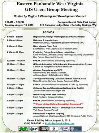
- 1. AGENDA 8:00am – 8:30am Registration (George Washington/Lord Fairfax Room) 8:30am– 9:00am Welcome & Introductions Matthew Mullenax, Hagerstown/Eastern Panhandle MPO 9:00am – 9:30am West Virginia Flood Tool Eric Hopkins, West Virginia GIS Technical Center 9:30am – 10:00am Predicting Future Growth From Unbuilt Lots Chris Whittaker, Jefferson County Planning and Zoning Department Clay Raines, Shepherd University 10:00am – 10:30am BREAK (Refreshments provided by Sponsors) 10:30am – 11:00am GIS and Automated Vehicle Locator Communications System Aaron Cox, Hampshire County Commission 11:00am – 11:30am Address Compliance and GPS Wendy Schutz and Jessica Gormont, Jefferson County GIS/Addressing Office 11:30am – 12:00pm Serving and Updating Cadastral Data for Public Kiosks Roger Kirkbride, Berkeley County Assessor’s Office 12:00pm – 1:00pm LUNCH (Provided free onsite to first 65 RSVPs by Sponsors) 1:00pm – 1:30pm Collector App and Operations Dashboard for ArcGIS Jake Skinner and Brad Songer, Esri 1:30pm – 2:00pm Martinsburg Urban Tree Inventory Frank Rodgers, Cacapon Institute 2:00pm – 2:30pm BREAK (Refreshments provided by Sponsors) ***Winner of Map Gallery Competition Announced*** 2:30pm – 3:00pm Mobile Options for ArcGIS – Selecting Your Solution York Grow, Duncan-Parnell 3:00pm – 3:30pm Introduction to Python Scripting Joseph Rathvon, Washington County MD Division of Public Works Please RSVP by Friday, August 9, 2013. (304) 263-1743 or kkeithley@region9wv.com Eastern Panhandle West Virginia GIS Users Group Meeting Hosted by Region 9 Planning and Development Council 8:00AM – 3:30PM Cacapon Resort State Park Lodge Tuesday, August 13, 2013 818 Cacapon Lodge Drive ▪ Berkeley Springs, WV
