
Recomendados
Más contenido relacionado
Destacado
Destacado (20)
Gis work samples
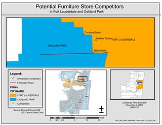
- 1. Potential Furniture Store Competitors in Fort Lauderdale and Oakland Park ContempSeats ^ Leather Styles FORT LAUDERDALE ^ OAKLAND PARK NatureSets ^ Legend: ^ Immediate Competitors _ ^ _ ^ _ ^ _ ^ Floranada Road _ ^ Cities CITYNAME FORT LAUDERDALE _ ^ OAKLAND PARK ± _ ^ _ ^ Created by Anna Bielawski ^ Competitors November 4, 2009 _ ^ URP6270 Source: Broward County GIS U.S. Census Retail Data _ ^ Miles 0 1.25 2.5 5 7.5 10 NAD_1983_HARN_StatePlane_Florida_East_FIPS_0901_Feet
- 2. Two Views of 2000 Population Density in Broward County Legend Population Density Per Sq Ft POP2000 / SHAPE_AREA 0.0004017 - 0.0009484 0.0002625 - 0.0004016 0.0001756 - 0.0002624 0.00009973 - 0.0001755 0.000001353 - 0.00009972 Feet 0 15,000 30,000 60,000 90,000 120,000 Legend Popultaion Density Per Sq Mile POP2000 / areasqmile 11210 - 26440 7317 - 11200 4894 - 7316 2781 - 4893 37.73 - 2780 Miles 0 2.5 5 10 15 20 Anna Bielawski October 14, 2009 Source: GIS.broward.org ± Coordinate System: NAD_1983_HARN_StatePlane_Florida_East_FIPS_0901_Feet
- 3. Two Techniques for Road Size Buffers Created by Anna Bielawski URP6270 ± Dec.9, 2009 Source: www.fgdl.org Disclaimer: This map is for educational purposes only NAD_1983_HARN_StatePlane_Florida_East_FIPS_0901_Feet Legend Legend Fort Lauderdale Roads Multiple Ring Buffer distance Fort Lauderdale Roads Buffer 25 Fort Lauderdale Tracts 25 - 50 50 - 75 75 - 100 Fort Lauderdale Tracts Feet Feet 0 4,000 8,000 16,000 24,000 32,000 0 4,000 8,000 16,000 24,000 32,000
- 4. 7 Best Houses for Sale in Canyon Crest R ¨ Q § ¦ Northside 215 Hunter Industrial Park 60 Downtown University ^ Eastside ^ Grand Wood Airport Streets ^ R Q91 ^ La Sierra Magnolia Acres Victoria Center Arlanza ^ Canyon Crest Sycamore La Sierra Hills Ramona Casa Hawarden Cyn Park 60 Sycamore Cyn/ R Q Blanca Hills Canyon Spgs ^ Arlington 91 Presidential R Q Alessandro Mission Park ^ La Sierra ^ Heights Grove Arlington South Arlington Heights ^ La Sierra South Orangecrest Anna Bielawski Legend URP6270 ^ Shopping Centers October 21, 2009 Freeways Selected CCbuildings CCbuildings Criteria for CCbuildings 1. Buildings have to be 2 miles from State 91 2. Buildings have to be 1 mile from shopping centers 3. Buildings have to have a shape area > 6000 feet ( 7 buildings meet this criteria ) 0 485 970 1,940 2,910 Feet 3,880 ± NAD_1983_StatePlane_California_VI_FIPS_0406_Feet Source: U.S. Census Data, City of Riverside GIS Data
- 5. Vacant Parcels Along Cypress Creek Rd. Fort Lauderdale, FL Legend Cypress Creek Road MajorRoads_Project1 Vacant Institutional Vacant Industrial Vacant Commercial Vacant Residential City Parcels ± Created by Anna Bielawski 0 2 4 8 12 16 10/28/09 Miles Into to GIS Sources: Broward County Appraiser's Office NAD 1983 HARN StatePlane Florida East FIPS 0901 Feet Parcel Use Code Parcel Type Number of Parcels Sum of Shape Area Sum of Land Values 00 Vacant Resiential 134 914369.0263 99510310 10 Vacant Commercial 28 5341283.6331 16442670 40 Vacant Industrial 4 147574.1800 1280110 70 Vacant Institutional 2 686924.9152 3442670
- 6. Florida Brownfield Areas and Major Highways in Clay and Duval Counties I-95 / R9 ST N S MAIN NE W KIN GS RD I-95 ATLANTIC BLVD 301 8 I-10 / SR US D BEACH BLVD 3RD ST S LV I-9 YB J T BUTLER BL VD 5 BLANDING BLVD ND /S A RM R 01 NO 9 US 3 SR 9A I-295/SR 9A 01 US 3 US 17 140 70 0 140 Miles SR 21 SR 16 SR 16 SR 16 SH Legend WY 17 Clay Major Highways Duval Major Highways Clay Brownfield Areas Duva lBrownfield Areas Clay County Ü 0 3.75 7.5 15 22.5 Miles 30 Duval County Created by Anna Bielawski Summary Table: Clay and Duval Counties URP6270 November 18, 2009 County Name Number of Brownfield Areas Total Acreage Source: FGDL Clay 1 5516.063 Duval 19 27858.305 Albers Conical Area
- 7. Potential Sites for Eco-Studies Center Fort Lauderdale Wetland Trail High School Slope Fort Lauderdale Legend I595 I95 Fort Lauderdale Streets Suitability Rankings VALUE Poor Suitability Average Suitability Good Suitability Best Suitability Parcel ± Created by Anna Bielawski Miles December 2, 2009 Source: FGDL, Broward GIS 0 0.45 0.9 1.8 2.7 3.6 This map provides a detailed suitability analysis for the best location for the Eco-Studies Center in Fort Lauderdale. The analysis looked at five main criteria: 1) a flat slope 2) proximity to nature trails 3) proximity to wetlands 4) distance from high schools (the further the better) and 5) vacant parcels. NAD_1983_HARN_StatePlane_Florida_East_FIPS_0901_Feet Disclaimer: This map is to be used for educational purposes only