
Recomendados
Más contenido relacionado
La actualidad más candente
La actualidad más candente (19)
Similar a The eight physical region of north america
Similar a The eight physical region of north america (20)
Último
Último (20)
The eight physical region of north america
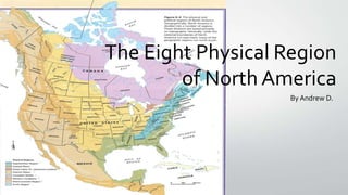
- 1. The Eight Physical Region of North America By Andrew D.
- 2. Table of Contends • • • • • • • • The Appalachian Region The Coastal Region The Great Lakes-St. Lawrence Lowland The Interior Plains The Western Cordillera The Canadian Shield The Intermountain Region The Arctic Region
- 3. The Appalachian Region • Topography • Vegetation • Climate • Economic Activity • Environmental Concerns
- 4. Topography • The Appalachian mountains are made up of many different mountain ranges • They are old mountains, formed about 300,000,000 years ago • Erosion has reduced the mountain’s once sharp, ragged peaks into rolling mountains and hills • The Appalachian region also contains rivers and fertile plateaus
- 5. Vegetation • The Appalachian region is heavily forested with coniferous and deciduous trees • The trees that live by the river have much richer soil, which makes the trees much healthier • These can also survive in poor and unproductive soil • The Appalachian region has a type of rock called Sedimentary • Sedimentary rock is a type of rock formed by erosion of other rocks
- 6. Climate • • • • The Appalachian region’s climate is affected by the two ocean currents The Labrador Current brings cold water south from the Arctic and causes freezing The Gulf Stream brings in warm water from the Caribbean and along the coast of North America Where the Gulf Stream and the Labrador Current meet is an ideal breeding ground for fish by encouraging the growth of plankton and microscopic organisms for food for the fish
- 7. Economic Activity • The Appalachian region is a 205,000 square mile region that follows the spine of the Appalachian Mountains from Southern New York to Northern Mississippi • 42% of the region’s population rural, compared with 20 percent of national population • The region’s economy, once highly dependant on mining, forestry, agriculture, chemical industries, and heavy industry, has become more diversified in recent times
- 8. Environmental Concerns • • • • Laurel Branch Hollow was once a small West Virginia mountain valley, with steep, forested hillsides and a stream Over the past decade, the Hobet 21 mountaintop removal coal mining operation has obliterated 25 square miles of the surrounding highlands When mountains are demolished with explosives to harvest their coal, million of tons of crushed shale, sandstone, and coal detritus have to go somewhere Mining operations clear-cut the hillsides and literally “fill” mountain hollows to the brim
- 9. Coastal Plains • Topography • Vegetation • Climate • Economic Activity • Environmental Concerns
- 10. Topography • • • • • The Coastal Plains have an average elevation of less than 200 meters above sea More than half of the Coastal Plains is less than 30 meters above sea level In the past, the gradual sinking of land allowed the sea to submerge to lower reaches of many streams across the plains The Hudson river, for example, can be navigated as far inland as Albany An important feature of the Gulf Coastal Plains is the Mississippi Delta – where the Mississippi empties into the Gulf of Mexico
- 11. Vegetation • The soils of the Coastal Plains are mainly very sandy • The natural vegetation has adapted to the sandy soil • In some areas (Mexico) lush jungles developed • The original vegetation of the area was pine forests
- 12. Climate • In the north, it is characterized by cold and snowy winters and hot, humid summers • The southern parts have a sub-tropical climate, with mild to warm winters • The southern parts of the region also have heavy hurricanes • Precipitation is high, particularly along the coast and seasonal
- 13. Economic Activity • The Coastal Plain’s main economic activities are tourism and recreation, shipping at the ports, paper-making, commercial fishing, and forestry • Coastal fisheries and forest resources support a number of industries engaged in economic activities • The economic activities of the Gulf Coastal Plains in east Texas is not good considering all the hurricanes flooding into the gulf in the past
- 14. Environmental Concerns • Some warn that unplanned growth could result in traffic jams and sewage spills and water shortages • Can be harming to the very ambience that draws so many to the region • Fragile habitats with endangered species could be threatened
- 15. The Great lakes-St. Lawrence Lowland • Topography • Vegetation • Climate • Economic Activity • Environmental Concerns
- 16. Topography • • • • The Great Lakes section of this region have rolling landscape created mainly by glaciation The St. Lawrence section consists of flat plains on either side of the river, which gradually begins to rise into the Canadian Shield and the Appalachian region Flat plains are broken by hills and deep river valleys Faults lead to the sinking of the area around the St. Lawrence, which was then flooded by part of the Atlantic Ocean
- 17. Vegetation • • • • Originally this region, which has very fertile soils, was heavily treed The Great Lakes section once had Canada’s largest broad-leafed forest, because its soil and climate conditions allowed maple, beech, hickory, and black walnut trees to thrive In other parts, the vegetation was mixed forest of both deciduous and conifers, such as maple, beech, oak, ash, birch, spruce, fir, pine, and cedar As well as, tobacco plants, peaches, cherries, grapes, apples, hay, and many other vegetables
- 18. Climate • The climate is a humid, continental climate, that is a dry climate with very cold winters and very hot summers • During the summer, the Great Lakes tend to lower the temperature • The Great Lakes also raise the temperature in the surrounding areas in the winter • The Great Lakes tend to cool the temperature during the summer by releasing the heat out of the area
- 19. Economic Activity • • • • Swimming, hockey, lacrosse, badminton, soccer and many other sports are examples of some activities As well as, fishing and boating Some popular attractions is the Niagara Falls in Ottawa and the CN Tower in Toronto Poultry, dairy, meat and specialty crop farming; car, steel and iron manufacturing; and copper, silver, lead zinc, and coal mining are all economic activities
- 20. Environmental Concerns • Since 1960, there has been an awakening of magnitude caused from pollution, habitat loss and exotic species • There has been a downfall in water quality and habitat began with modern settlement • Agricultural development, forestry, and urbanization caused streams and shoreline marshes to silt up and harbour areas to become septic
- 21. Interior Plains • Topography • Vegetation • Climate • Economic Activity • Environmental Concerns
- 22. Topography • • • • In the US, Interior Plains are divided into the Central Lowland and the Great in Plains The northern border of the Central Lowland is formed by the Canadian Shield, the Great Lakes, and the St. Lawrence River The Great Plains are higher elevation than the Central Lowland, rising from about 600 meters to 1500 meters above sea level in the west In Canada’s prairie provinces, the Interior Plains contain three different elevation, which are separated by escarpments
- 23. Vegetation • • • • Once the Central Lowland east of the Mississippi was covered with mixed deciduous trees and scattered evergreens West of the Mississippi, in the Great Plains, prairie grasses grew as tall as a person The natural vegetation was also grassland – trees grew only in the river valleys In the northern portion of the Interior Plains, boreal forests grows, gradually becoming tundra towards the Arctic Ocean
- 24. Climate • The climate of the Interior Plains is a continental climate, affected by its location in the heart of the continent • It is a climate of extremes, including long, hot summers, cold winters, and little precipitation • Farther north, the winters are colder and longer, and the summers are shorter and cooler
- 25. Economic Activity • The Interior Plains have a couple of major economic activities such as, agriculture and mining • The agriculture is split into 2 parts; livestock and vegetable • The livestock grown in the in the Interior Plains are cattle, pigs, poultry, etc. • Vegetables grown in the Interior Plains are; wheat, barley, oats flax, canola, mustard, potatoes, corn, and sugar beets
- 26. Environmental Concerns • Farm pollutants seeping into the ground and/or operating off into the river and lake programs • Incorporated industries and other human activities such as; driving automobiles, disposing waste into landfills and lumber harvesting
- 27. Canadian Shield • Topography • Vegetation • Climate • Economic Activity • Environmental Concerns
- 28. Topography • • • • During the Ice Age, glaciers removed most of the soil, leaving a barren rock surface in many places The retreat of the glaciers affected the drainage of the Shield to significant degree Debris deposited by the glaciers damned up rivers, or forced them to flow in different directions The average elevation of the Shield is about 100 metres above sea level in the north, rising to about 500 metres in the south
- 29. Vegetation • Boreal forests covers most of the Shield, since evergreens, such as spruce, pine, and fir • North of the tree line, no trees are able to grow; the growing season is too short, there is little rain, and there is permafrost • Some deciduous trees, such as poplar and white birch, are small and weak, more suited to the pulp and paper industry than to lumbering
- 30. Climate • The climate varies throughout the vast area covered by the Canadian Shield • As you travel north, the winters become increasingly longer and colder; with the summers becoming shorter and cooler
- 31. Economic Activity • The Canadian Shield is Canada’s largest physiographic region, which stretches from the north-east of the Northwest Territories to the south of Ontario • The Canadian Shield produces significant economic activity through its lumber industry and mining operations • The Shield is one of the richest areas in terms of mineral ores
- 32. Environmental Concerns • Coal-burning factories, cars, and trucks release chemicals that pollute the air • High levels of acids in rain can damage or kill trees and pollute lakes enough to kill fish • Blasting and digging with heavy machinery causes the land around mines to be damaged and the environmental is often ruined
- 33. Western Cordillera • Topography • Vegetation • Climate • Economic Activity • Environmental Concerns
- 34. Topography • The Western Cordillera is comprised of new mountains not yet worn down by erosion • They are more than twice as high as the Appalachian Mountains in the east • They are many different mountain ranges in this region; such as the Rocky Mountains, and the Continental Divide • All the rivers east of the Rockies flow east, finding their way into the Gulf of Mexico
- 35. Vegetation • • • • Western Cordillera vegetation varies from one side of a mountain to the other On the moist side, windward slopes evergreens, such as the Douglas fir, western hemlock, and western red cedar, grow to tremendous age and size on the lower slopes The giant sequoia, the largest tree in the world, grows near Yosemite At the very top of the mountains, the vegetation becomes similar to the tundra, or it ceases entirely
- 36. Climate • The west coast has a marine time climate • The west coast is mild and moist, and parts of it are among the wettest regions on Earth • Moderated by the water of the Pacific Ocean, winters are usually above freezing • Summers are cooler than the Interior of the continent
- 37. Economic Activity • Farming, Mining, and fishing are examples of economic activities • Tourism would be also an economic activity since many tourists come to see the beautiful scenery in the towns of Banff and Jasper
- 38. Environmental Concerns • There are some types of birds, squirrels and asparagus going endangered • The timber industry cutting out large pieces of forests
- 39. Intermountain Region • Topography • Vegetation • Climate • Economic Activity • Environmental Concerns
- 40. Topography • In many areas, the streams and rivers of the Intermountain Region’s mountains and plateaus never reach the sea • They flow into brackish lakes, such as the Great Salt Lake in Utah • In this region, there are areas that can be made productive by irrigation • The Intermountain region covers many various areas between the ocean coast and the Rocky Mountain; its many wetlands, rivers, and lakes provide habitats for many birds
- 41. Vegetation • The vegetation of the Intermountain region generally ranges between sparse grassland to plants that can survive in semi-desert or desert conditions • The higher areas are covered by thin pin forests
- 42. Climate • The climate of the Intermountain region is affected by its location and by its elevation • Winters can be cool and wet or hot and dry, depending what part it is • In the southern part, winters are short and warm with very little rain • In the northern part, the climate is more moderate, with moist winters and hot, dry summers
- 43. Economic Activity • The main economic activities are forestry and agriculture • Some of the flowers grown include the Western Yallow, Blue Camas and the Arrow leaf Balsamroot • Forestation is a very important economic activity; trees such as pine and cedar are grown in the Intermountain region
- 44. Environmental Concerns • Global Warming has a massive effect on the Intermountain region • It has increased the severity of droughts, winter flows and floods • Global warming has endangered many of Intermountain region’s wildlife; such as the sage, grouse, and the Northern salmon
- 45. The Arctic • Topography • Vegetation • Climate • Economic Activity • Environmental Concerns
- 46. Topography • Most of the Arctic near the ocean is very flat • The mountains of the north were formed by folding and are presently covered by glaciers
- 47. Vegetation • Very few plant life can survive here; can grow on the mountains of the Arctic • Trees cannot grow in the tundra, because the climate is too cold and dry, and only thaws a bit in the summer • Small shrubs, mosses, and lichens are the only things that grow • They cling to the ground and absorb any warmth and moisture
- 48. Climate • Very few plant life can survive here; can grow on the mountains of the Arctic • Trees cannot grow in the tundra, because the climate is too cold and dry, and only thaws a bit in the summer • Small shrubs, mosses, and lichens are the only things that grow • They cling to the ground and absorb any warmth and moisture
- 49. Economic Activity • A main economic activity is the search for oil, gas and other minerals in the Arctic Sea • In 2008, the Americans discovered 90 barrels of oil, and 44 barrels of natural gas liquids in the Arctic Circle • This represents 13% of the world’s undiscovered oil and natural gas
- 50. Environmental Concerns • The Arctic continues to rise, and has caused a significant increase in sea level • As the ice melts, the Arctic waters continuously to get warmer, because it allows more solar energy to be absorbed by the oceans