1. This is probably the most asked question posed to those in the Geographic Information Systems (GIS)
field and is probably the hardest to answer in a succinct and clear manner. GIS is a technological field
that incorporates geographical features with tabular data in order to map, analyze, and assess real -
world problems. The key word to this technology is Geography – this means that some portion of the
data is spatial. In other words, data that is in some way referenced to locations on the earth. Coupled
with this data is usually tabular data known as attribute data. Attribute data can be generally defined as
additional information about each of the spatial features. An example of this would be schools. The
actual location of the schools is the spatial data. Additional data such as the school name, level of
education taught, student capacity would make up the attribute data. It is the partnership of these two
data types that enables GIS to be such an effective problem solving tool through spatial analysis.
GIS operates on many levels. On the most basic level, geographic information systems technology is
used as computer cartography, that is for straight forward mapping. The real power of GIS is through
using spatial and statistical methods to analyze attribute and geographic information. The end result of
the analysis can be derivative information, interpolated information or prioritized information.
GIS Versus Geospatial
There is an increasing trend to use the term geospatial instead of GIS. What is the difference between
geospatial and GIS? Although some may use the terms interchangeably, there is a distinct difference
between the two in that GIS refers more narrowly to the traditional definition of using layers of
geographic data to produce spatial analysis and derivative maps. Geospatial is more broadly use to refer
to all technologies and applications of geographic data. For example, popular social media sites such as
Foursquare and Facebook use “check-ins” that allow their users the ability to geographically tag their
statuses. While those applications are considered to be geospatial, they don’t fall underneath the
stricter definition of what makes up a geographic information system. More: What’s is the Difference
Between GIS and Geospatial?
Other quotes to answer “What is GIS?”
“In the strictest sense, a GIS is a computer system capable of assembling, storing, manipulating, and
displaying geographically referenced information, i.e. data identified according to their locations.
Practitioners also regard the total GIS as including operating personnel and the data that go into the
system.” ~ USGS“
A geographic information system (GIS) is a computer-based tool for mapping and analyzing things that
exist and events that happen on earth. GIS technology integrates common database operations such as
query and statistical analysis with the unique visualization and geographic analysis benefits offered by
maps.” ~ ESRI
“GIS is an integrated system of computer hardware, software, and trained personnel linking topographic,
demographic, utility, facility, image and other resource data that is geographically referenced.” ~ NASA
2. “A geographic information system is a special case of information systems where the database consists
of observations on spatially distributed features, activities or events, which are definable in space as
points, lines, or areas. A geographic information system manipulates data about these points, lines, and
areas to retrieve data for ad hoc queries and analyses” (Kenneth Dueker,Portland State
University, 1979).
GIS has already affected most of us in some way without us even realizing it. If you’ve ever using an
Internet mapping program to find directions, congratulations, you’ve personally used GIS. The new
supermarket chain on the corner was probably located using GIS to determine the most effective place
to meet customer demand.
Uses of GIS
There are numerous ways in which this technology can be used. The most common ones are:
1. Management of resources
2. Investigations of the earth’s surface that is scientific in nature
3. Archeological uses
4. Planning of locations and management of assets
5. Urban & regional planning
6. Criminology matters
7. An Impact assessment of the environment
8. The assessment and eventual development of infrastructure
9. Studies of the demographics of an area plus its population
10. Analysis with regards to engineering
Some of the common instances where you will find the GIS in use include:
1. Emergency response teams normally use GIS when they want to collect logistics with regards to
how they will move in times of natural disasters.
2. The system also comes in handy when authorities want to discover any potential wetlands that
need to be protected from the harmful effects brought about by pollution.
3. Companies also take advantage of the GIS so that they may be able to choose a strategic market
location that has not yet been saturated by other competitors in the particular niche industry.
4. Management personnel use this system also so that they can be able to locate areas that are
bound to suffer from catastrophes with regards to the infrastructure that is in place there.
3. 5. Any potential spread of diseases & other such like pandemic are usually limited by the use of the
GIS since the patterns of their occurrence is predicted in sufficient time.
The Development of GIS
One of the most famous early examples of spatial analysis can be traced back to London in the year
1854 when Dr. John Snow was able to predict the occurrence of cholera outbreak. Thanks to the study
that Snow released, officials from the government were able to determine the cause of the disease;
which was contaminated water from one of the major pumps. The map that Snow came up with was
very interesting in that it had the capability of analyzing the phenomena relating to their geographical
positions and this was the first time the world was witnessing this. Photozincography was developed in
the earlier years of the 1900s and this enabled the maps to be divided into various layers as required. In
the initial stages, the process of drawing these maps was lengthy since it involved free hand but this
changed later on with the introduction of the computer.
The first GIS was created by Dr. Roger Tomlinson and then introduced in the early 1960s in Canada.
During its inception, this system was mainly meant for collecting, storing and then analyzing the
capability & potential which the land in the rural areas had. Prior to this, mapping by the use of
computers was being used for such cases but this is a method that had numerous limitations associated
to it. By the end of the 80s period, the use of GIS had already become popular in other related fields
which is why it led to a spur in the growth of the industrial sector. Recently, designers came up with
open source software for GIS so that the brilliant technology can be enhanced in a much simpler manner
while being made available to all.
Components of GIS
The next step in understanding GIS is to look at each area and how they work together. These
components are:
Hardware
Software
Data
People
Hardware
Hardware comprises the equipment needed to support the many activities needed for geospatial
analysis ranging from data collection to data analysis. The central piece of equipment is the workstation,
which runs the GIS software and is the attachment point for ancillary equipment. Data collection efforts
can also require the use of a digitizer for conversion of hard copy data to digital data and a GPS data
logger to collect data in the field. The use of handheld field technology is also becoming an important
4. data collection tool in GIS. With the advent of web mapping, web servers have also become an
important piece of equipment.
Software
Different types of software are important. Central to this is the GIS application package. Such software is
essential for creating, editing and analyzing spatial and attribute data, therefore these packages contain
a myriad of geospatial functions inherent to them. Extensions or add-ons are software that extends the
capabilities of the GIS software package. Component GIS software is the opposite of application
software.Component GIS seeks to build software applications that meet a specific purpose and thus are
limited in their spatial analysis capabilities. Utilities are stand-alone programs that perform a specific
function. For example, a file format utility that converts from on type of GIS file to another. There is
also web GISsoftware that helps serve data and interactive maps through Internet browsers.
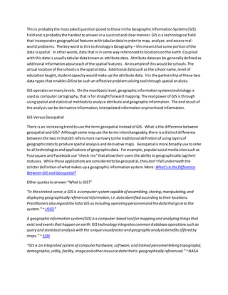
Data
Data is the core of any GIS. There are two primary types of data that are used in GIS: vector and raster
data. A geodatabase is a database that is in some way referenced to locations on the earth.
Geodatabases are grouped into two different types: vector and raster. Vector data is spatial data
represented as points, lines and polygons. Raster data is cell-based data such as aerial imagery and
digital elevation models. Coupled with this data is usually data known as attribute data. Attribute data
generally defined as additional information about each spatial feature housed in tabular format.
Documentation of GIS datasets is known as metadata. Metadata contains such information as the
coordinate system, when the data was created, when it was last updated, who created it and how to
contact them and definitions for any of the code attribute data.
5. GIS DATA LAYERS. SOURCE: FCDC
People
Well-trained GIS professionals knowledgeable in spatial analysis and skilled in using GIS software are
essential to the GIS process. There are three factors to the people component: education, career path,
and networking. The right education is key; taking the right combination of classes. Selecting the right
type of GIS job is important. A person highly skilled in GIS analysis should not seek a job as a GIS
developer if they haven’t taken the necessary programming classes. Finally, continuous networking with
other GIS professionals is essential for the exchange of ideas as well as a support community