SlideShare una empresa de Scribd logo
1 de 23
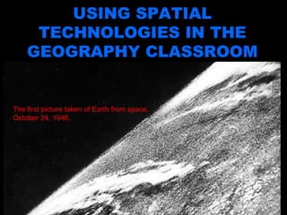
Using Spatial Technologies in the Geography Classroom USING SPATIAL TECHNOLOGIES IN THE GEOGRAPHY CLASSROOM The first picture taken of Earth from space, October 24, 1946.
Spatial literacy and spatial technologies To be considered ‘spatially literate’, an individual must have the ability to capture and communicate knowledge in the form of a map, to understand and recognise the world as view from above, to recognise and interpret patterns, and to comprehend such basic concepts as scale, projection and spatial resolution Goodchild (2006)
What are spatial technologies Spatial technologies include any form of technology that refers to place, space and location. Specifically, they are technologies that organize and collect data, by referencing the information collected to a point on the earth’s surface using latitude and longitude.   Image taken by Apollo 11, 1969
Eighty per cent of all information gathered today has a spatial or geographical component. This means that most information is tied to a place.  This is a Landsat 7 Satellite image (WRS Path 179, Row 77, centre: -24.56, 14.93) of Namib-Naukluft National Park in Namibia's vast Namib Desert – Taken from  Earth as Art.
Since the development of Google Earth in 2005, there has been a surge of innovation as new technologies have linked places on the internet to places in the real world.
The power of spatial technologies to communicate a message have become more obvious.
Remote sensing is the science and art of obtaining information about the Earth’s surface without being in contact with it.  Remote Sensing and Imagery Taken from  Earth as Art.
Global positioning systems GPS GPS is a satellite-based navigation technology that uses a network of 24 satellites placed in orbit to determine locations on earth.
http://www.newscientist.com/article.ns?id=dn5079
http://www.smh.com.au/news/technology/gpsequipped-jacket-lets-parents-track-their-children/2007/10/25/1192941200365.html
Geocaching is a high-tech treasure hunt where you use a GPS receiver to find caches (treasures) hidden by other players.  http://geocaching.com.au/
http://www.confluence.org/
A computer-based mapping software that collects, stores and analyses previously unrelated information into easily understood maps.   The GIS program represents the data as layers of information (called themes). These layers of data can be turned on or off, according to what the user wants to look at and the relationships they are trying to find.   Geographic information systems GIS
“ The most terrible outbreak of cholera which occurred in this kingdom is probably that which took place in Broad Street, Golden Square and adjoining streets [of Soho]…there were upwards of five hundred attacks of cholera in ten days”. Dr John Snow The first GIS map?
 
http://maps.google.com/
http://earth.google.com/ Google Earth
Globalis: An Interactive World Map http://globalis.gvu.unu.edu/
http://www.ozcoasts.org.au/
http://www.pdc.org/atlas/html/atlas-viewer.jsp
http://risingfromruin.msnbc.com/stories.html Virtual field trips
Online Map Linked to Fatal Turn Sydney Morning Herald Questionable directions given by online mapping services could have contributed to the death of James Kim, who perished while trying to save his stranded family.   Asher Moses, 8 th  December, 2006 Insurgents ‘Using Google Earth’ Telegraph.co.uk Insurgents could be using satellite images from a popular website to mount attacks on British and American bases in Iraq, defence experts said last night. Jasper Copping, 17 th  December 2005 SPATIAL TECHNOLOGIES: IN THE NEWS
 

Más contenido relacionado

La actualidad más candente

Spatial Analysis Using GIS
Spatial Analysis Using GISSpatial Analysis Using GIS
Spatial Analysis Using GISPrachi Mehta
 
WEB GIS AND WEB MAP.pptx
WEB GIS AND WEB MAP.pptxWEB GIS AND WEB MAP.pptx
WEB GIS AND WEB MAP.pptxAsim Pt
 
Introduction to GIS
Introduction to GISIntroduction to GIS
Introduction to GISJoey Li
 
Surface Representations using GIS AND Topographical Mapping
Surface Representations using GIS AND Topographical MappingSurface Representations using GIS AND Topographical Mapping
Surface Representations using GIS AND Topographical MappingNAXA-Developers
 
ppt spatial data
ppt spatial datappt spatial data
ppt spatial dataRahul Kumar
 
geographic information system(gis) (1).pdf
geographic information system(gis) (1).pdfgeographic information system(gis) (1).pdf
geographic information system(gis) (1).pdfShubham30007
 
Application of gis in urban planning
Application of gis in urban planningApplication of gis in urban planning
Application of gis in urban planningWESLEY MELI
 
Geography Skills: Scale
Geography Skills:  ScaleGeography Skills:  Scale
Geography Skills: ScaleTim Bonnar
 
Structure of geographic data
Structure of geographic dataStructure of geographic data
Structure of geographic dataMd. Yousuf Gazi
 
Introduction to Geographic Information System (GIS)
Introduction to Geographic Information System (GIS)Introduction to Geographic Information System (GIS)
Introduction to Geographic Information System (GIS)Shashank Singh
 
Geographic information system
Geographic information systemGeographic information system
Geographic information systemOssamaElShanawany
 

La actualidad más candente (20)

Introduction to GIS
Introduction to GISIntroduction to GIS
Introduction to GIS
 
Digital Cartography
Digital CartographyDigital Cartography
Digital Cartography
 
Spatial Analysis Using GIS
Spatial Analysis Using GISSpatial Analysis Using GIS
Spatial Analysis Using GIS
 
Cartographic map design
Cartographic map designCartographic map design
Cartographic map design
 
WEB GIS AND WEB MAP.pptx
WEB GIS AND WEB MAP.pptxWEB GIS AND WEB MAP.pptx
WEB GIS AND WEB MAP.pptx
 
Introduction to GIS
Introduction to GISIntroduction to GIS
Introduction to GIS
 
Coordinate systems
Coordinate systemsCoordinate systems
Coordinate systems
 
Surface Representations using GIS AND Topographical Mapping
Surface Representations using GIS AND Topographical MappingSurface Representations using GIS AND Topographical Mapping
Surface Representations using GIS AND Topographical Mapping
 
History of GIS.pptx
History of GIS.pptxHistory of GIS.pptx
History of GIS.pptx
 
ppt spatial data
ppt spatial datappt spatial data
ppt spatial data
 
geographic information system(gis) (1).pdf
geographic information system(gis) (1).pdfgeographic information system(gis) (1).pdf
geographic information system(gis) (1).pdf
 
DTM DEM Generation
DTM DEM GenerationDTM DEM Generation
DTM DEM Generation
 
Application of gis in urban planning
Application of gis in urban planningApplication of gis in urban planning
Application of gis in urban planning
 
Geography Skills: Scale
Geography Skills:  ScaleGeography Skills:  Scale
Geography Skills: Scale
 
Geographical Information System.ppt
Geographical Information System.pptGeographical Information System.ppt
Geographical Information System.ppt
 
Geo-spatial Analysis and Modelling
Geo-spatial Analysis and ModellingGeo-spatial Analysis and Modelling
Geo-spatial Analysis and Modelling
 
Structure of geographic data
Structure of geographic dataStructure of geographic data
Structure of geographic data
 
Introduction to Geographic Information System (GIS)
Introduction to Geographic Information System (GIS)Introduction to Geographic Information System (GIS)
Introduction to Geographic Information System (GIS)
 
Geographic information system
Geographic information systemGeographic information system
Geographic information system
 
Fundamentals of GIS
Fundamentals of GISFundamentals of GIS
Fundamentals of GIS
 

Similar a Using Spatial Technologies in the Geography Classroom

Cartography: Web 2.0
Cartography: Web 2.0Cartography: Web 2.0
Cartography: Web 2.0rosaleal2010
 
Satellite Imigery imint-secrets.pdf
Satellite Imigery imint-secrets.pdfSatellite Imigery imint-secrets.pdf
Satellite Imigery imint-secrets.pdfGodsWrath
 
Cartography and Geospatial Intelligence (GEOINT): Actionable Knowledge for Hu...
Cartography and Geospatial Intelligence (GEOINT): Actionable Knowledge for Hu...Cartography and Geospatial Intelligence (GEOINT): Actionable Knowledge for Hu...
Cartography and Geospatial Intelligence (GEOINT): Actionable Knowledge for Hu...British Cartographic Society
 
Lunar Mission One Overview May 2015
Lunar Mission One Overview May 2015Lunar Mission One Overview May 2015
Lunar Mission One Overview May 2015Heather Drake
 
Visualizations and Mashups in Online News Production
Visualizations and Mashups in Online News ProductionVisualizations and Mashups in Online News Production
Visualizations and Mashups in Online News ProductionAndy Sternberg
 
Development Challenges, South-South Solutions: September 2013 Issue
Development Challenges, South-South Solutions: September 2013 Issue Development Challenges, South-South Solutions: September 2013 Issue
Development Challenges, South-South Solutions: September 2013 Issue David South Consulting
 
What is geostationary satellite
What is geostationary satelliteWhat is geostationary satellite
What is geostationary satelliteDPSG
 
Geocaching 101: Making Connections to Your Curriculum
Geocaching 101:  Making Connections to Your CurriculumGeocaching 101:  Making Connections to Your Curriculum
Geocaching 101: Making Connections to Your CurriculumConni Mulligan
 
Geographic Information Systems (GIS).pptx
Geographic  Information Systems (GIS).pptxGeographic  Information Systems (GIS).pptx
Geographic Information Systems (GIS).pptxEllenGracePorras
 
Head in the clouds: Engaging with the web for archaeologists
Head in the clouds: Engaging with the web for archaeologistsHead in the clouds: Engaging with the web for archaeologists
Head in the clouds: Engaging with the web for archaeologistsdavstott
 
Planet Labs Case Study
 Planet Labs Case Study Planet Labs Case Study
Planet Labs Case StudyGOVINDYADAV56
 

Similar a Using Spatial Technologies in the Geography Classroom (20)

Design Notebook GPS
Design Notebook GPSDesign Notebook GPS
Design Notebook GPS
 
Cartography: Web 2.0
Cartography: Web 2.0Cartography: Web 2.0
Cartography: Web 2.0
 
RJW Back to the Future
RJW Back to the FutureRJW Back to the Future
RJW Back to the Future
 
DSWD FIGHTERS
DSWD FIGHTERSDSWD FIGHTERS
DSWD FIGHTERS
 
imint-secrets.pdf
imint-secrets.pdfimint-secrets.pdf
imint-secrets.pdf
 
Satellite Imigery imint-secrets.pdf
Satellite Imigery imint-secrets.pdfSatellite Imigery imint-secrets.pdf
Satellite Imigery imint-secrets.pdf
 
Photogrammetry
PhotogrammetryPhotogrammetry
Photogrammetry
 
RI:Lab Cartocracy
RI:Lab CartocracyRI:Lab Cartocracy
RI:Lab Cartocracy
 
History of GIS.pdf
History of GIS.pdfHistory of GIS.pdf
History of GIS.pdf
 
Cartography and Geospatial Intelligence (GEOINT): Actionable Knowledge for Hu...
Cartography and Geospatial Intelligence (GEOINT): Actionable Knowledge for Hu...Cartography and Geospatial Intelligence (GEOINT): Actionable Knowledge for Hu...
Cartography and Geospatial Intelligence (GEOINT): Actionable Knowledge for Hu...
 
Lunar Mission One Overview May 2015
Lunar Mission One Overview May 2015Lunar Mission One Overview May 2015
Lunar Mission One Overview May 2015
 
Visualizations and Mashups in Online News Production
Visualizations and Mashups in Online News ProductionVisualizations and Mashups in Online News Production
Visualizations and Mashups in Online News Production
 
Development Challenges, South-South Solutions: September 2013 Issue
Development Challenges, South-South Solutions: September 2013 Issue Development Challenges, South-South Solutions: September 2013 Issue
Development Challenges, South-South Solutions: September 2013 Issue
 
Google earth with 07+ 03df+coll
Google earth with 07+ 03df+collGoogle earth with 07+ 03df+coll
Google earth with 07+ 03df+coll
 
What is geostationary satellite
What is geostationary satelliteWhat is geostationary satellite
What is geostationary satellite
 
Geocaching 101: Making Connections to Your Curriculum
Geocaching 101:  Making Connections to Your CurriculumGeocaching 101:  Making Connections to Your Curriculum
Geocaching 101: Making Connections to Your Curriculum
 
Geographic Information Systems (GIS).pptx
Geographic  Information Systems (GIS).pptxGeographic  Information Systems (GIS).pptx
Geographic Information Systems (GIS).pptx
 
Geoeverything
GeoeverythingGeoeverything
Geoeverything
 
Head in the clouds: Engaging with the web for archaeologists
Head in the clouds: Engaging with the web for archaeologistsHead in the clouds: Engaging with the web for archaeologists
Head in the clouds: Engaging with the web for archaeologists
 
Planet Labs Case Study
 Planet Labs Case Study Planet Labs Case Study
Planet Labs Case Study
 

Más de Rebecca Nicholas

Coastal Fieldwork Assessment Task
Coastal Fieldwork Assessment TaskCoastal Fieldwork Assessment Task
Coastal Fieldwork Assessment TaskRebecca Nicholas
 
East Timor Thinking Questions
East Timor Thinking QuestionsEast Timor Thinking Questions
East Timor Thinking QuestionsRebecca Nicholas
 
Understanding the Exchange Rate
Understanding the Exchange RateUnderstanding the Exchange Rate
Understanding the Exchange RateRebecca Nicholas
 
Spatial Technology Resources for Teachers
Spatial Technology Resources for TeachersSpatial Technology Resources for Teachers
Spatial Technology Resources for TeachersRebecca Nicholas
 

Más de Rebecca Nicholas (6)

Coastal Fieldwork Booklet
Coastal Fieldwork BookletCoastal Fieldwork Booklet
Coastal Fieldwork Booklet
 
Coastal Fieldwork Assessment Task
Coastal Fieldwork Assessment TaskCoastal Fieldwork Assessment Task
Coastal Fieldwork Assessment Task
 
East Timor Thinking Questions
East Timor Thinking QuestionsEast Timor Thinking Questions
East Timor Thinking Questions
 
Understanding the Exchange Rate
Understanding the Exchange RateUnderstanding the Exchange Rate
Understanding the Exchange Rate
 
Spatial Technology Resources for Teachers
Spatial Technology Resources for TeachersSpatial Technology Resources for Teachers
Spatial Technology Resources for Teachers
 
What is Web 2.0?
What is Web 2.0? What is Web 2.0?
What is Web 2.0?
 

Último

Paris 2024 Olympic Geographies - an activity
Paris 2024 Olympic Geographies - an activityParis 2024 Olympic Geographies - an activity
Paris 2024 Olympic Geographies - an activityGeoBlogs
 
Measures of Dispersion and Variability: Range, QD, AD and SD
Measures of Dispersion and Variability: Range, QD, AD and SDMeasures of Dispersion and Variability: Range, QD, AD and SD
Measures of Dispersion and Variability: Range, QD, AD and SDThiyagu K
 
How to Give a Domain for a Field in Odoo 17
How to Give a Domain for a Field in Odoo 17How to Give a Domain for a Field in Odoo 17
How to Give a Domain for a Field in Odoo 17Celine George
 
Introduction to Nonprofit Accounting: The Basics
Introduction to Nonprofit Accounting: The BasicsIntroduction to Nonprofit Accounting: The Basics
Introduction to Nonprofit Accounting: The BasicsTechSoup
 
Class 11th Physics NEET formula sheet pdf
Class 11th Physics NEET formula sheet pdfClass 11th Physics NEET formula sheet pdf
Class 11th Physics NEET formula sheet pdfAyushMahapatra5
 
fourth grading exam for kindergarten in writing
fourth grading exam for kindergarten in writingfourth grading exam for kindergarten in writing
fourth grading exam for kindergarten in writingTeacherCyreneCayanan
 
Basic Civil Engineering first year Notes- Chapter 4 Building.pptx
Basic Civil Engineering first year Notes- Chapter 4 Building.pptxBasic Civil Engineering first year Notes- Chapter 4 Building.pptx
Basic Civil Engineering first year Notes- Chapter 4 Building.pptxDenish Jangid
 
Ecological Succession. ( ECOSYSTEM, B. Pharmacy, 1st Year, Sem-II, Environmen...
Ecological Succession. ( ECOSYSTEM, B. Pharmacy, 1st Year, Sem-II, Environmen...Ecological Succession. ( ECOSYSTEM, B. Pharmacy, 1st Year, Sem-II, Environmen...
Ecological Succession. ( ECOSYSTEM, B. Pharmacy, 1st Year, Sem-II, Environmen...Shubhangi Sonawane
 
psychiatric nursing HISTORY COLLECTION .docx
psychiatric  nursing HISTORY  COLLECTION  .docxpsychiatric  nursing HISTORY  COLLECTION  .docx
psychiatric nursing HISTORY COLLECTION .docxPoojaSen20
 
Russian Escort Service in Delhi 11k Hotel Foreigner Russian Call Girls in Delhi
Russian Escort Service in Delhi 11k Hotel Foreigner Russian Call Girls in DelhiRussian Escort Service in Delhi 11k Hotel Foreigner Russian Call Girls in Delhi
Russian Escort Service in Delhi 11k Hotel Foreigner Russian Call Girls in Delhikauryashika82
 
Grant Readiness 101 TechSoup and Remy Consulting
Grant Readiness 101 TechSoup and Remy ConsultingGrant Readiness 101 TechSoup and Remy Consulting
Grant Readiness 101 TechSoup and Remy ConsultingTechSoup
 
Nutritional Needs Presentation - HLTH 104
Nutritional Needs Presentation - HLTH 104Nutritional Needs Presentation - HLTH 104
Nutritional Needs Presentation - HLTH 104misteraugie
 
The basics of sentences session 2pptx copy.pptx
The basics of sentences session 2pptx copy.pptxThe basics of sentences session 2pptx copy.pptx
The basics of sentences session 2pptx copy.pptxheathfieldcps1
 
Mixin Classes in Odoo 17 How to Extend Models Using Mixin Classes
Mixin Classes in Odoo 17  How to Extend Models Using Mixin ClassesMixin Classes in Odoo 17  How to Extend Models Using Mixin Classes
Mixin Classes in Odoo 17 How to Extend Models Using Mixin ClassesCeline George
 
Advanced Views - Calendar View in Odoo 17
Advanced Views - Calendar View in Odoo 17Advanced Views - Calendar View in Odoo 17
Advanced Views - Calendar View in Odoo 17Celine George
 
Holdier Curriculum Vitae (April 2024).pdf
Holdier Curriculum Vitae (April 2024).pdfHoldier Curriculum Vitae (April 2024).pdf
Holdier Curriculum Vitae (April 2024).pdfagholdier
 

Último (20)

Advance Mobile Application Development class 07
Advance Mobile Application Development class 07Advance Mobile Application Development class 07
Advance Mobile Application Development class 07
 
Paris 2024 Olympic Geographies - an activity
Paris 2024 Olympic Geographies - an activityParis 2024 Olympic Geographies - an activity
Paris 2024 Olympic Geographies - an activity
 
Measures of Dispersion and Variability: Range, QD, AD and SD
Measures of Dispersion and Variability: Range, QD, AD and SDMeasures of Dispersion and Variability: Range, QD, AD and SD
Measures of Dispersion and Variability: Range, QD, AD and SD
 
How to Give a Domain for a Field in Odoo 17
How to Give a Domain for a Field in Odoo 17How to Give a Domain for a Field in Odoo 17
How to Give a Domain for a Field in Odoo 17
 
INDIA QUIZ 2024 RLAC DELHI UNIVERSITY.pptx
INDIA QUIZ 2024 RLAC DELHI UNIVERSITY.pptxINDIA QUIZ 2024 RLAC DELHI UNIVERSITY.pptx
INDIA QUIZ 2024 RLAC DELHI UNIVERSITY.pptx
 
Introduction to Nonprofit Accounting: The Basics
Introduction to Nonprofit Accounting: The BasicsIntroduction to Nonprofit Accounting: The Basics
Introduction to Nonprofit Accounting: The Basics
 
Class 11th Physics NEET formula sheet pdf
Class 11th Physics NEET formula sheet pdfClass 11th Physics NEET formula sheet pdf
Class 11th Physics NEET formula sheet pdf
 
fourth grading exam for kindergarten in writing
fourth grading exam for kindergarten in writingfourth grading exam for kindergarten in writing
fourth grading exam for kindergarten in writing
 
Basic Civil Engineering first year Notes- Chapter 4 Building.pptx
Basic Civil Engineering first year Notes- Chapter 4 Building.pptxBasic Civil Engineering first year Notes- Chapter 4 Building.pptx
Basic Civil Engineering first year Notes- Chapter 4 Building.pptx
 
Ecological Succession. ( ECOSYSTEM, B. Pharmacy, 1st Year, Sem-II, Environmen...
Ecological Succession. ( ECOSYSTEM, B. Pharmacy, 1st Year, Sem-II, Environmen...Ecological Succession. ( ECOSYSTEM, B. Pharmacy, 1st Year, Sem-II, Environmen...
Ecological Succession. ( ECOSYSTEM, B. Pharmacy, 1st Year, Sem-II, Environmen...
 
psychiatric nursing HISTORY COLLECTION .docx
psychiatric  nursing HISTORY  COLLECTION  .docxpsychiatric  nursing HISTORY  COLLECTION  .docx
psychiatric nursing HISTORY COLLECTION .docx
 
Russian Escort Service in Delhi 11k Hotel Foreigner Russian Call Girls in Delhi
Russian Escort Service in Delhi 11k Hotel Foreigner Russian Call Girls in DelhiRussian Escort Service in Delhi 11k Hotel Foreigner Russian Call Girls in Delhi
Russian Escort Service in Delhi 11k Hotel Foreigner Russian Call Girls in Delhi
 
Grant Readiness 101 TechSoup and Remy Consulting
Grant Readiness 101 TechSoup and Remy ConsultingGrant Readiness 101 TechSoup and Remy Consulting
Grant Readiness 101 TechSoup and Remy Consulting
 
Nutritional Needs Presentation - HLTH 104
Nutritional Needs Presentation - HLTH 104Nutritional Needs Presentation - HLTH 104
Nutritional Needs Presentation - HLTH 104
 
The basics of sentences session 2pptx copy.pptx
The basics of sentences session 2pptx copy.pptxThe basics of sentences session 2pptx copy.pptx
The basics of sentences session 2pptx copy.pptx
 
Código Creativo y Arte de Software | Unidad 1
Código Creativo y Arte de Software | Unidad 1Código Creativo y Arte de Software | Unidad 1
Código Creativo y Arte de Software | Unidad 1
 
Mixin Classes in Odoo 17 How to Extend Models Using Mixin Classes
Mixin Classes in Odoo 17  How to Extend Models Using Mixin ClassesMixin Classes in Odoo 17  How to Extend Models Using Mixin Classes
Mixin Classes in Odoo 17 How to Extend Models Using Mixin Classes
 
Advanced Views - Calendar View in Odoo 17
Advanced Views - Calendar View in Odoo 17Advanced Views - Calendar View in Odoo 17
Advanced Views - Calendar View in Odoo 17
 
Mattingly "AI & Prompt Design: The Basics of Prompt Design"
Mattingly "AI & Prompt Design: The Basics of Prompt Design"Mattingly "AI & Prompt Design: The Basics of Prompt Design"
Mattingly "AI & Prompt Design: The Basics of Prompt Design"
 
Holdier Curriculum Vitae (April 2024).pdf
Holdier Curriculum Vitae (April 2024).pdfHoldier Curriculum Vitae (April 2024).pdf
Holdier Curriculum Vitae (April 2024).pdf
 

Using Spatial Technologies in the Geography Classroom

  • 1. Using Spatial Technologies in the Geography Classroom USING SPATIAL TECHNOLOGIES IN THE GEOGRAPHY CLASSROOM The first picture taken of Earth from space, October 24, 1946.
  • 2. Spatial literacy and spatial technologies To be considered ‘spatially literate’, an individual must have the ability to capture and communicate knowledge in the form of a map, to understand and recognise the world as view from above, to recognise and interpret patterns, and to comprehend such basic concepts as scale, projection and spatial resolution Goodchild (2006)
  • 3. What are spatial technologies Spatial technologies include any form of technology that refers to place, space and location. Specifically, they are technologies that organize and collect data, by referencing the information collected to a point on the earth’s surface using latitude and longitude. Image taken by Apollo 11, 1969
  • 4. Eighty per cent of all information gathered today has a spatial or geographical component. This means that most information is tied to a place. This is a Landsat 7 Satellite image (WRS Path 179, Row 77, centre: -24.56, 14.93) of Namib-Naukluft National Park in Namibia's vast Namib Desert – Taken from Earth as Art.
  • 5. Since the development of Google Earth in 2005, there has been a surge of innovation as new technologies have linked places on the internet to places in the real world.
  • 6. The power of spatial technologies to communicate a message have become more obvious.
  • 7. Remote sensing is the science and art of obtaining information about the Earth’s surface without being in contact with it. Remote Sensing and Imagery Taken from Earth as Art.
  • 8. Global positioning systems GPS GPS is a satellite-based navigation technology that uses a network of 24 satellites placed in orbit to determine locations on earth.
  • 11. Geocaching is a high-tech treasure hunt where you use a GPS receiver to find caches (treasures) hidden by other players. http://geocaching.com.au/
  • 13. A computer-based mapping software that collects, stores and analyses previously unrelated information into easily understood maps. The GIS program represents the data as layers of information (called themes). These layers of data can be turned on or off, according to what the user wants to look at and the relationships they are trying to find. Geographic information systems GIS
  • 14. “ The most terrible outbreak of cholera which occurred in this kingdom is probably that which took place in Broad Street, Golden Square and adjoining streets [of Soho]…there were upwards of five hundred attacks of cholera in ten days”. Dr John Snow The first GIS map?
  • 15.  
  • 18. Globalis: An Interactive World Map http://globalis.gvu.unu.edu/
  • 22. Online Map Linked to Fatal Turn Sydney Morning Herald Questionable directions given by online mapping services could have contributed to the death of James Kim, who perished while trying to save his stranded family. Asher Moses, 8 th December, 2006 Insurgents ‘Using Google Earth’ Telegraph.co.uk Insurgents could be using satellite images from a popular website to mount attacks on British and American bases in Iraq, defence experts said last night. Jasper Copping, 17 th December 2005 SPATIAL TECHNOLOGIES: IN THE NEWS
  • 23.