SlideShare una empresa de Scribd logo
1 de 22
UNIT 1 - MAPS
1- How is the Earth represented?
2- What types of maps are there?
3- How do we locate places on maps?
4- How do we represent scale on a map?
Glossary
It is a drawing of a particular area such as a city, a
country, or a continent, showing its main features.
Map
It is one of the four principal compass points:
north, south, east, and west.
Cardinal
point
It is the information given with the map to explain the
meaning of the symbols and colours drawn on it.Map key
It refers to the relationship between distance on a map and
the corresponding distance on the ground.
Scale map
Glossary
Meridian It is an imaginary line between the North Pole and the South Pole,
drawn to help to locate any place on the Earth.
Parallel
It is an imaginary line drawn on the Earth´s surface which is
perpendicular to the meridians. The most important parallel is
the Equator.
Latitude
It is a geographical coordinate; it indicates thenorth/south
position of a point on the Earth´s surface. It ranges from 0
degrees at the Equator to 90º at the Pole (North/South)
Longitude
It is a geographical coordinate; it indicates the east/west position
of a point on the Earth´s surface. It ranges from 0 degrees at the
Prime Meridian to 180º at the Antimeridian.
1- How is the Earth represented?
The Earth is spherical but slightly flattened at the
poles
geoid
How do we represent the Earth?
Globe
Maps
How is the Earth in shape?
Three-dimensional
Not detailed information
Easy to carry
Two dimensional
Practical information
1- How is the Earth represented?
What are the cardinals points?
The elements we use to establish direction; the
principal are north, south, east and west.
Do you know any other elements that can help us to
establish direction?
Nature
The Sun
North Star
Instruments Compass: always points north
Always indicates north
Rises in the east; sets in the
west.
1- How is the Earth represented?
How is the Earth in shape?
How do we represent the Earth?
What are the cardinals points?
Do you know any other elements that can help
us to establish direction?
Think: Nowadays we have modern instruments like GPS or digital maps that
allow us to establish direction easily; Why do you think it´s important to learn
the traditional methods to orient yourself or navigate?
2- What types of maps are there?
Types of
maps
Physical Information on relief and rivers
One specific physical map is the topographic map (It
also details names, roads, buildings…)
Thematic Information on one particular subject
Political Information on political organisation:
frontiers, capital cities..
2- What types of maps are there?
Which are the basic elements of a map?
2- What types of maps are there?Which
elements
are missing?
2- What types of maps are there?Which
elements
are missing?
2- What types of maps are there?
Name and describe the main types of maps
Which are the basic elements of a map? Describe their function.
Activities 1,2 and 3 on page 9.
3- How do we locate places on maps?
Meridians and parallels It is a grid of imaginary lines that enable us to
identify the exact location of places on Earth.
Meridians
Parallels
Semicircles which go from one Pole to the
other.
Prime meridian (0º) is the reference for other
meridians.
Circles which are perpendicular to the meridians
The Equator is the most important; divides the Earth in
two hemispheres.
Other parallels
Artic Circle
Tropic of Cancer
Tropic of Capricorn
Antarctic Circle
https://www.youtube.com/watch?v=ChBhKPh
B4VE&list=PLc-
jghROQMcLrGQCkLn4Cr9avGfkJ-_IM&index=1
Arctic Circle
Prime meridian
Equator
Tropic of
Cancer
Tropic of
Capricorn
Antarctic Circle
Western
Hemisphere
Prime meridian
Eastern
Hemisphere
The prime meridian divides the Earth in two halves: the western and the
eastern hemisphere.
Northern
hemisphere
Equator
Southern
hemisphere
The Equator divides the Earth in two halves: the northern and the southern
hemisphere.
3- How do we locate places on maps?
Define parallels and meridians.
Which one is the main meridian?
Which are the main parallels?
What is the Equator?
Explain the differences between the parallels and the meridians?
Parallels and
meridians
3- How do we locate places on maps?
Geographical coordinates
It is a system that enables every location on
Earth to be specificied.
The geographical coordinates are the latitude and
the longitude.
Latitude
Measured by using the parallels
From 0º to 90º; north or south
All locations on the same
parallel have the same
latitude.
Distance to Equator measured in degrees.
Longitude
Distance to Prime Meridian measured in degrees.
Measured by using the meridians
All locations on the same
meridian have the same
longitude.
From 0º to 180º; east or west
3- How do we locate places on maps?
Latitude and
longitude
Explain the difference between latitude and longitude
Activity 1 on page 11.
https://www.youtube.com/watch?v=T1E0I4eL
KNI
https://www.geovista.psu.edu/grants/
MapStatsKids/MSK_portal/concepts_l
atlg.html
3- How do we locate places on maps?
Latitude and
longitude
Latitude Longitude
London
Rome
Quito
Kinshasa
21º S 38º W
38º N 140º E
32º S 150º E
52º N 0º
Río de Janeiro
42º N 13º E
0º 75º W
Tokio
3º S 17º E
Sydney
4- How do we represent scale on a map
Scale Map element that indicates the difference between the size of
something in the real world and its size on a map.
Map scale types
https://kidsgeo.com/geography-for-kids/map-
scale-types/
The scale of a map uses a representative
fraction to describe the ratio between the map
and the real world.
Numeric scale
(fractional
method)
4- How do we represent scale on a map?
Graphic scale
(Graphic
method)
A line divided into equal segements. The number
indicates the size which each segment represents.

Más contenido relacionado

La actualidad más candente (20)

Map skills
Map skillsMap skills
Map skills
 
POLITICAL MAPS REINO LA PUEBLA
POLITICAL MAPS REINO LA PUEBLAPOLITICAL MAPS REINO LA PUEBLA
POLITICAL MAPS REINO LA PUEBLA
 
Map Elements
Map ElementsMap Elements
Map Elements
 
Map and globe skills vocabulary words
Map and globe skills vocabulary wordsMap and globe skills vocabulary words
Map and globe skills vocabulary words
 
Maps
MapsMaps
Maps
 
UNIT 5. SOCIAL SCIENCE: MAPS AND GLOBES
UNIT 5. SOCIAL SCIENCE: MAPS AND GLOBESUNIT 5. SOCIAL SCIENCE: MAPS AND GLOBES
UNIT 5. SOCIAL SCIENCE: MAPS AND GLOBES
 
What is a map- Introduction to Map Skills Presentation
What is a map- Introduction to Map Skills PresentationWhat is a map- Introduction to Map Skills Presentation
What is a map- Introduction to Map Skills Presentation
 
Basics of Map reading
Basics of Map reading Basics of Map reading
Basics of Map reading
 
Map and globe skills
Map and globe skillsMap and globe skills
Map and globe skills
 
Models and dimensions of earth
Models and dimensions of earthModels and dimensions of earth
Models and dimensions of earth
 
Geography Skills
Geography SkillsGeography Skills
Geography Skills
 
Chapter 4 maps ppt
Chapter 4 maps pptChapter 4 maps ppt
Chapter 4 maps ppt
 
Geography Skills Review
Geography Skills ReviewGeography Skills Review
Geography Skills Review
 
Maps and globes
Maps and globesMaps and globes
Maps and globes
 
Maps and globes
Maps and globesMaps and globes
Maps and globes
 
GEOGRAPHY YEAR 9 SKILLS - MAPS
GEOGRAPHY YEAR 9 SKILLS - MAPSGEOGRAPHY YEAR 9 SKILLS - MAPS
GEOGRAPHY YEAR 9 SKILLS - MAPS
 
Globe
GlobeGlobe
Globe
 
Maps and globes
Maps and globesMaps and globes
Maps and globes
 
Location ppt
Location pptLocation ppt
Location ppt
 
Map and globe
Map and globeMap and globe
Map and globe
 

Similar a Unit 1 Maps

Maps as Models of Earth
Maps as Models of EarthMaps as Models of Earth
Maps as Models of Earthmlong24
 
Maps as Models of Earth
Maps as Models of EarthMaps as Models of Earth
Maps as Models of Earthmlong24
 
Reading & interpreting maps notes
Reading & interpreting maps notesReading & interpreting maps notes
Reading & interpreting maps notescareycannon
 
Reading & interpreting maps notes
Reading & interpreting maps notesReading & interpreting maps notes
Reading & interpreting maps notescareycannon
 
The Geographer's Toolbox
The Geographer's ToolboxThe Geographer's Toolbox
The Geographer's ToolboxSandy Anthony
 
Ss3 m1 u01_presentation
Ss3 m1 u01_presentationSs3 m1 u01_presentation
Ss3 m1 u01_presentationdfr4591
 
SOCIAL SCIENCE WORLD
SOCIAL SCIENCE WORLDSOCIAL SCIENCE WORLD
SOCIAL SCIENCE WORLDLuciaAbalos
 
Map projection Map and Globe
Map projection Map and GlobeMap projection Map and Globe
Map projection Map and GlobeKaluramChouhan
 
Unit 5 Orientation and Maps
Unit 5 Orientation and MapsUnit 5 Orientation and Maps
Unit 5 Orientation and MapsYourTeachers
 
5 themes and map skills
5 themes and map skills 5 themes and map skills
5 themes and map skills Úcar Marian
 
Social Science Unit 1 Our World presentation
Social Science Unit 1 Our World presentationSocial Science Unit 1 Our World presentation
Social Science Unit 1 Our World presentationBlanca Francisco Tardón
 
BOLTSS - Mapping Geography
BOLTSS - Mapping GeographyBOLTSS - Mapping Geography
BOLTSS - Mapping GeographyYaryalitsa
 
maps & symbols which is use in india and other parts of world also
maps & symbols which is use in india and other parts of world alsomaps & symbols which is use in india and other parts of world also
maps & symbols which is use in india and other parts of world alsoLakshya Sharma
 
whatisamap-140703092843-phpapp02.pdf
whatisamap-140703092843-phpapp02.pdfwhatisamap-140703092843-phpapp02.pdf
whatisamap-140703092843-phpapp02.pdfshucaybcabdi
 
Unit 1, part 3 the study of geography, cartographers' tools
Unit 1, part 3 the study of geography, cartographers' toolsUnit 1, part 3 the study of geography, cartographers' tools
Unit 1, part 3 the study of geography, cartographers' toolsmontathomas
 

Similar a Unit 1 Maps (20)

Geography
GeographyGeography
Geography
 
Map Reading Skills.pptx
Map Reading Skills.pptxMap Reading Skills.pptx
Map Reading Skills.pptx
 
Readingmaps
ReadingmapsReadingmaps
Readingmaps
 
Maps as Models of Earth
Maps as Models of EarthMaps as Models of Earth
Maps as Models of Earth
 
Maps as Models of Earth
Maps as Models of EarthMaps as Models of Earth
Maps as Models of Earth
 
Reading & interpreting maps notes
Reading & interpreting maps notesReading & interpreting maps notes
Reading & interpreting maps notes
 
Reading & interpreting maps notes
Reading & interpreting maps notesReading & interpreting maps notes
Reading & interpreting maps notes
 
The Geographer's Toolbox
The Geographer's ToolboxThe Geographer's Toolbox
The Geographer's Toolbox
 
Ss3 m1 u01_presentation
Ss3 m1 u01_presentationSs3 m1 u01_presentation
Ss3 m1 u01_presentation
 
SOCIAL SCIENCE WORLD
SOCIAL SCIENCE WORLDSOCIAL SCIENCE WORLD
SOCIAL SCIENCE WORLD
 
Readingmaps 1
Readingmaps 1Readingmaps 1
Readingmaps 1
 
Map projection Map and Globe
Map projection Map and GlobeMap projection Map and Globe
Map projection Map and Globe
 
Exploring geography
Exploring geographyExploring geography
Exploring geography
 
Unit 5 Orientation and Maps
Unit 5 Orientation and MapsUnit 5 Orientation and Maps
Unit 5 Orientation and Maps
 
5 themes and map skills
5 themes and map skills 5 themes and map skills
5 themes and map skills
 
Social Science Unit 1 Our World presentation
Social Science Unit 1 Our World presentationSocial Science Unit 1 Our World presentation
Social Science Unit 1 Our World presentation
 
BOLTSS - Mapping Geography
BOLTSS - Mapping GeographyBOLTSS - Mapping Geography
BOLTSS - Mapping Geography
 
maps & symbols which is use in india and other parts of world also
maps & symbols which is use in india and other parts of world alsomaps & symbols which is use in india and other parts of world also
maps & symbols which is use in india and other parts of world also
 
whatisamap-140703092843-phpapp02.pdf
whatisamap-140703092843-phpapp02.pdfwhatisamap-140703092843-phpapp02.pdf
whatisamap-140703092843-phpapp02.pdf
 
Unit 1, part 3 the study of geography, cartographers' tools
Unit 1, part 3 the study of geography, cartographers' toolsUnit 1, part 3 the study of geography, cartographers' tools
Unit 1, part 3 the study of geography, cartographers' tools
 

Más de Carlos Arrese

Introduction to history
Introduction to historyIntroduction to history
Introduction to historyCarlos Arrese
 
Unit 9 renaissance and reformation
Unit 9 renaissance and reformationUnit 9 renaissance and reformation
Unit 9 renaissance and reformationCarlos Arrese
 
Unit 7 the age of discovery
Unit 7 the age of discoveryUnit 7 the age of discovery
Unit 7 the age of discoveryCarlos Arrese
 
Indice preguntas 1 a 13
Indice preguntas 1 a 13Indice preguntas 1 a 13
Indice preguntas 1 a 13Carlos Arrese
 
Unit 11 Ancient Rome
Unit 11 Ancient RomeUnit 11 Ancient Rome
Unit 11 Ancient RomeCarlos Arrese
 
Unit 10 Ancient Greece
Unit 10 Ancient GreeceUnit 10 Ancient Greece
Unit 10 Ancient GreeceCarlos Arrese
 
Unit 9 Early Civilizations.pptx
Unit 9 Early Civilizations.pptx  Unit 9 Early Civilizations.pptx
Unit 9 Early Civilizations.pptx Carlos Arrese
 
Tema 7 Los espacios de servicios
Tema 7  Los espacios de serviciosTema 7  Los espacios de servicios
Tema 7 Los espacios de serviciosCarlos Arrese
 
Tema 6 los espacios industriales
Tema 6  los espacios industrialesTema 6  los espacios industriales
Tema 6 los espacios industrialesCarlos Arrese
 
Unit 4 weather and climate
Unit 4 weather and climateUnit 4 weather and climate
Unit 4 weather and climateCarlos Arrese
 
Unit 4 Weather and climate
Unit 4 Weather and climateUnit 4 Weather and climate
Unit 4 Weather and climateCarlos Arrese
 
Tema 5 los espacios del sector primario
Tema 5  los espacios del sector primarioTema 5  los espacios del sector primario
Tema 5 los espacios del sector primarioCarlos Arrese
 
Unit 2 Physical Geography
Unit 2 Physical GeographyUnit 2 Physical Geography
Unit 2 Physical GeographyCarlos Arrese
 
Unit 9 Renaissance and Reformation
Unit 9 Renaissance and ReformationUnit 9 Renaissance and Reformation
Unit 9 Renaissance and ReformationCarlos Arrese
 
Tema 10 El imperio de los Austrias
Tema 10 El imperio de los AustriasTema 10 El imperio de los Austrias
Tema 10 El imperio de los AustriasCarlos Arrese
 

Más de Carlos Arrese (20)

Introduction to history
Introduction to historyIntroduction to history
Introduction to history
 
Unit 9 renaissance and reformation
Unit 9 renaissance and reformationUnit 9 renaissance and reformation
Unit 9 renaissance and reformation
 
Unit 7 the age of discovery
Unit 7 the age of discoveryUnit 7 the age of discovery
Unit 7 the age of discovery
 
El Franquismo
El Franquismo El Franquismo
El Franquismo
 
Indice preguntas 1 a 13
Indice preguntas 1 a 13Indice preguntas 1 a 13
Indice preguntas 1 a 13
 
Unit 11 Ancient Rome
Unit 11 Ancient RomeUnit 11 Ancient Rome
Unit 11 Ancient Rome
 
Unit 10 Ancient Greece
Unit 10 Ancient GreeceUnit 10 Ancient Greece
Unit 10 Ancient Greece
 
Unit 9 Early Civilizations.pptx
Unit 9 Early Civilizations.pptx  Unit 9 Early Civilizations.pptx
Unit 9 Early Civilizations.pptx
 
Tema 7 Los espacios de servicios
Tema 7  Los espacios de serviciosTema 7  Los espacios de servicios
Tema 7 Los espacios de servicios
 
Tema 6 los espacios industriales
Tema 6  los espacios industrialesTema 6  los espacios industriales
Tema 6 los espacios industriales
 
Unit 4 weather and climate
Unit 4 weather and climateUnit 4 weather and climate
Unit 4 weather and climate
 
Unit 4 Weather and climate
Unit 4 Weather and climateUnit 4 Weather and climate
Unit 4 Weather and climate
 
Tema 5 los espacios del sector primario
Tema 5  los espacios del sector primarioTema 5  los espacios del sector primario
Tema 5 los espacios del sector primario
 
Unit 3 water
Unit 3 waterUnit 3 water
Unit 3 water
 
Recursos hidricos
Recursos hidricosRecursos hidricos
Recursos hidricos
 
Tema 2 clima
Tema 2   climaTema 2   clima
Tema 2 clima
 
Unit 2 Physical Geography
Unit 2 Physical GeographyUnit 2 Physical Geography
Unit 2 Physical Geography
 
Tema 1 Relieve
Tema 1  RelieveTema 1  Relieve
Tema 1 Relieve
 
Unit 9 Renaissance and Reformation
Unit 9 Renaissance and ReformationUnit 9 Renaissance and Reformation
Unit 9 Renaissance and Reformation
 
Tema 10 El imperio de los Austrias
Tema 10 El imperio de los AustriasTema 10 El imperio de los Austrias
Tema 10 El imperio de los Austrias
 

Último

Student login on Anyboli platform.helpin
Student login on Anyboli platform.helpinStudent login on Anyboli platform.helpin
Student login on Anyboli platform.helpinRaunakKeshri1
 
Web & Social Media Analytics Previous Year Question Paper.pdf
Web & Social Media Analytics Previous Year Question Paper.pdfWeb & Social Media Analytics Previous Year Question Paper.pdf
Web & Social Media Analytics Previous Year Question Paper.pdfJayanti Pande
 
mini mental status format.docx
mini    mental       status     format.docxmini    mental       status     format.docx
mini mental status format.docxPoojaSen20
 
The Most Excellent Way | 1 Corinthians 13
The Most Excellent Way | 1 Corinthians 13The Most Excellent Way | 1 Corinthians 13
The Most Excellent Way | 1 Corinthians 13Steve Thomason
 
Privatization and Disinvestment - Meaning, Objectives, Advantages and Disadva...
Privatization and Disinvestment - Meaning, Objectives, Advantages and Disadva...Privatization and Disinvestment - Meaning, Objectives, Advantages and Disadva...
Privatization and Disinvestment - Meaning, Objectives, Advantages and Disadva...RKavithamani
 
URLs and Routing in the Odoo 17 Website App
URLs and Routing in the Odoo 17 Website AppURLs and Routing in the Odoo 17 Website App
URLs and Routing in the Odoo 17 Website AppCeline George
 
Introduction to AI in Higher Education_draft.pptx
Introduction to AI in Higher Education_draft.pptxIntroduction to AI in Higher Education_draft.pptx
Introduction to AI in Higher Education_draft.pptxpboyjonauth
 
Industrial Policy - 1948, 1956, 1973, 1977, 1980, 1991
Industrial Policy - 1948, 1956, 1973, 1977, 1980, 1991Industrial Policy - 1948, 1956, 1973, 1977, 1980, 1991
Industrial Policy - 1948, 1956, 1973, 1977, 1980, 1991RKavithamani
 
“Oh GOSH! Reflecting on Hackteria's Collaborative Practices in a Global Do-It...
“Oh GOSH! Reflecting on Hackteria's Collaborative Practices in a Global Do-It...“Oh GOSH! Reflecting on Hackteria's Collaborative Practices in a Global Do-It...
“Oh GOSH! Reflecting on Hackteria's Collaborative Practices in a Global Do-It...Marc Dusseiller Dusjagr
 
1029 - Danh muc Sach Giao Khoa 10 . pdf
1029 -  Danh muc Sach Giao Khoa 10 . pdf1029 -  Danh muc Sach Giao Khoa 10 . pdf
1029 - Danh muc Sach Giao Khoa 10 . pdfQucHHunhnh
 
Z Score,T Score, Percential Rank and Box Plot Graph
Z Score,T Score, Percential Rank and Box Plot GraphZ Score,T Score, Percential Rank and Box Plot Graph
Z Score,T Score, Percential Rank and Box Plot GraphThiyagu K
 
1029-Danh muc Sach Giao Khoa khoi 6.pdf
1029-Danh muc Sach Giao Khoa khoi  6.pdf1029-Danh muc Sach Giao Khoa khoi  6.pdf
1029-Danh muc Sach Giao Khoa khoi 6.pdfQucHHunhnh
 
Separation of Lanthanides/ Lanthanides and Actinides
Separation of Lanthanides/ Lanthanides and ActinidesSeparation of Lanthanides/ Lanthanides and Actinides
Separation of Lanthanides/ Lanthanides and ActinidesFatimaKhan178732
 
microwave assisted reaction. General introduction
microwave assisted reaction. General introductionmicrowave assisted reaction. General introduction
microwave assisted reaction. General introductionMaksud Ahmed
 
CARE OF CHILD IN INCUBATOR..........pptx
CARE OF CHILD IN INCUBATOR..........pptxCARE OF CHILD IN INCUBATOR..........pptx
CARE OF CHILD IN INCUBATOR..........pptxGaneshChakor2
 
BASLIQ CURRENT LOOKBOOK LOOKBOOK(1) (1).pdf
BASLIQ CURRENT LOOKBOOK  LOOKBOOK(1) (1).pdfBASLIQ CURRENT LOOKBOOK  LOOKBOOK(1) (1).pdf
BASLIQ CURRENT LOOKBOOK LOOKBOOK(1) (1).pdfSoniaTolstoy
 
Mastering the Unannounced Regulatory Inspection
Mastering the Unannounced Regulatory InspectionMastering the Unannounced Regulatory Inspection
Mastering the Unannounced Regulatory InspectionSafetyChain Software
 
Interactive Powerpoint_How to Master effective communication
Interactive Powerpoint_How to Master effective communicationInteractive Powerpoint_How to Master effective communication
Interactive Powerpoint_How to Master effective communicationnomboosow
 

Último (20)

Student login on Anyboli platform.helpin
Student login on Anyboli platform.helpinStudent login on Anyboli platform.helpin
Student login on Anyboli platform.helpin
 
Web & Social Media Analytics Previous Year Question Paper.pdf
Web & Social Media Analytics Previous Year Question Paper.pdfWeb & Social Media Analytics Previous Year Question Paper.pdf
Web & Social Media Analytics Previous Year Question Paper.pdf
 
mini mental status format.docx
mini    mental       status     format.docxmini    mental       status     format.docx
mini mental status format.docx
 
The Most Excellent Way | 1 Corinthians 13
The Most Excellent Way | 1 Corinthians 13The Most Excellent Way | 1 Corinthians 13
The Most Excellent Way | 1 Corinthians 13
 
Privatization and Disinvestment - Meaning, Objectives, Advantages and Disadva...
Privatization and Disinvestment - Meaning, Objectives, Advantages and Disadva...Privatization and Disinvestment - Meaning, Objectives, Advantages and Disadva...
Privatization and Disinvestment - Meaning, Objectives, Advantages and Disadva...
 
URLs and Routing in the Odoo 17 Website App
URLs and Routing in the Odoo 17 Website AppURLs and Routing in the Odoo 17 Website App
URLs and Routing in the Odoo 17 Website App
 
Introduction to AI in Higher Education_draft.pptx
Introduction to AI in Higher Education_draft.pptxIntroduction to AI in Higher Education_draft.pptx
Introduction to AI in Higher Education_draft.pptx
 
Código Creativo y Arte de Software | Unidad 1
Código Creativo y Arte de Software | Unidad 1Código Creativo y Arte de Software | Unidad 1
Código Creativo y Arte de Software | Unidad 1
 
Mattingly "AI & Prompt Design: Structured Data, Assistants, & RAG"
Mattingly "AI & Prompt Design: Structured Data, Assistants, & RAG"Mattingly "AI & Prompt Design: Structured Data, Assistants, & RAG"
Mattingly "AI & Prompt Design: Structured Data, Assistants, & RAG"
 
Industrial Policy - 1948, 1956, 1973, 1977, 1980, 1991
Industrial Policy - 1948, 1956, 1973, 1977, 1980, 1991Industrial Policy - 1948, 1956, 1973, 1977, 1980, 1991
Industrial Policy - 1948, 1956, 1973, 1977, 1980, 1991
 
“Oh GOSH! Reflecting on Hackteria's Collaborative Practices in a Global Do-It...
“Oh GOSH! Reflecting on Hackteria's Collaborative Practices in a Global Do-It...“Oh GOSH! Reflecting on Hackteria's Collaborative Practices in a Global Do-It...
“Oh GOSH! Reflecting on Hackteria's Collaborative Practices in a Global Do-It...
 
1029 - Danh muc Sach Giao Khoa 10 . pdf
1029 -  Danh muc Sach Giao Khoa 10 . pdf1029 -  Danh muc Sach Giao Khoa 10 . pdf
1029 - Danh muc Sach Giao Khoa 10 . pdf
 
Z Score,T Score, Percential Rank and Box Plot Graph
Z Score,T Score, Percential Rank and Box Plot GraphZ Score,T Score, Percential Rank and Box Plot Graph
Z Score,T Score, Percential Rank and Box Plot Graph
 
1029-Danh muc Sach Giao Khoa khoi 6.pdf
1029-Danh muc Sach Giao Khoa khoi  6.pdf1029-Danh muc Sach Giao Khoa khoi  6.pdf
1029-Danh muc Sach Giao Khoa khoi 6.pdf
 
Separation of Lanthanides/ Lanthanides and Actinides
Separation of Lanthanides/ Lanthanides and ActinidesSeparation of Lanthanides/ Lanthanides and Actinides
Separation of Lanthanides/ Lanthanides and Actinides
 
microwave assisted reaction. General introduction
microwave assisted reaction. General introductionmicrowave assisted reaction. General introduction
microwave assisted reaction. General introduction
 
CARE OF CHILD IN INCUBATOR..........pptx
CARE OF CHILD IN INCUBATOR..........pptxCARE OF CHILD IN INCUBATOR..........pptx
CARE OF CHILD IN INCUBATOR..........pptx
 
BASLIQ CURRENT LOOKBOOK LOOKBOOK(1) (1).pdf
BASLIQ CURRENT LOOKBOOK  LOOKBOOK(1) (1).pdfBASLIQ CURRENT LOOKBOOK  LOOKBOOK(1) (1).pdf
BASLIQ CURRENT LOOKBOOK LOOKBOOK(1) (1).pdf
 
Mastering the Unannounced Regulatory Inspection
Mastering the Unannounced Regulatory InspectionMastering the Unannounced Regulatory Inspection
Mastering the Unannounced Regulatory Inspection
 
Interactive Powerpoint_How to Master effective communication
Interactive Powerpoint_How to Master effective communicationInteractive Powerpoint_How to Master effective communication
Interactive Powerpoint_How to Master effective communication
 

Unit 1 Maps

  • 1. UNIT 1 - MAPS 1- How is the Earth represented? 2- What types of maps are there? 3- How do we locate places on maps? 4- How do we represent scale on a map?
  • 2. Glossary It is a drawing of a particular area such as a city, a country, or a continent, showing its main features. Map It is one of the four principal compass points: north, south, east, and west. Cardinal point It is the information given with the map to explain the meaning of the symbols and colours drawn on it.Map key It refers to the relationship between distance on a map and the corresponding distance on the ground. Scale map
  • 3. Glossary Meridian It is an imaginary line between the North Pole and the South Pole, drawn to help to locate any place on the Earth. Parallel It is an imaginary line drawn on the Earth´s surface which is perpendicular to the meridians. The most important parallel is the Equator. Latitude It is a geographical coordinate; it indicates thenorth/south position of a point on the Earth´s surface. It ranges from 0 degrees at the Equator to 90º at the Pole (North/South) Longitude It is a geographical coordinate; it indicates the east/west position of a point on the Earth´s surface. It ranges from 0 degrees at the Prime Meridian to 180º at the Antimeridian.
  • 4. 1- How is the Earth represented? The Earth is spherical but slightly flattened at the poles geoid How do we represent the Earth? Globe Maps How is the Earth in shape? Three-dimensional Not detailed information Easy to carry Two dimensional Practical information
  • 5. 1- How is the Earth represented? What are the cardinals points? The elements we use to establish direction; the principal are north, south, east and west. Do you know any other elements that can help us to establish direction? Nature The Sun North Star Instruments Compass: always points north Always indicates north Rises in the east; sets in the west.
  • 6. 1- How is the Earth represented? How is the Earth in shape? How do we represent the Earth? What are the cardinals points? Do you know any other elements that can help us to establish direction? Think: Nowadays we have modern instruments like GPS or digital maps that allow us to establish direction easily; Why do you think it´s important to learn the traditional methods to orient yourself or navigate?
  • 7. 2- What types of maps are there? Types of maps Physical Information on relief and rivers One specific physical map is the topographic map (It also details names, roads, buildings…) Thematic Information on one particular subject Political Information on political organisation: frontiers, capital cities..
  • 8. 2- What types of maps are there? Which are the basic elements of a map?
  • 9. 2- What types of maps are there?Which elements are missing?
  • 10. 2- What types of maps are there?Which elements are missing?
  • 11. 2- What types of maps are there? Name and describe the main types of maps Which are the basic elements of a map? Describe their function. Activities 1,2 and 3 on page 9.
  • 12. 3- How do we locate places on maps? Meridians and parallels It is a grid of imaginary lines that enable us to identify the exact location of places on Earth. Meridians Parallels Semicircles which go from one Pole to the other. Prime meridian (0º) is the reference for other meridians. Circles which are perpendicular to the meridians The Equator is the most important; divides the Earth in two hemispheres. Other parallels Artic Circle Tropic of Cancer Tropic of Capricorn Antarctic Circle https://www.youtube.com/watch?v=ChBhKPh B4VE&list=PLc- jghROQMcLrGQCkLn4Cr9avGfkJ-_IM&index=1
  • 13.
  • 14. Arctic Circle Prime meridian Equator Tropic of Cancer Tropic of Capricorn Antarctic Circle
  • 15. Western Hemisphere Prime meridian Eastern Hemisphere The prime meridian divides the Earth in two halves: the western and the eastern hemisphere.
  • 16. Northern hemisphere Equator Southern hemisphere The Equator divides the Earth in two halves: the northern and the southern hemisphere.
  • 17. 3- How do we locate places on maps? Define parallels and meridians. Which one is the main meridian? Which are the main parallels? What is the Equator? Explain the differences between the parallels and the meridians? Parallels and meridians
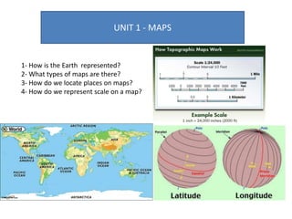
  • 18. 3- How do we locate places on maps? Geographical coordinates It is a system that enables every location on Earth to be specificied. The geographical coordinates are the latitude and the longitude. Latitude Measured by using the parallels From 0º to 90º; north or south All locations on the same parallel have the same latitude. Distance to Equator measured in degrees. Longitude Distance to Prime Meridian measured in degrees. Measured by using the meridians All locations on the same meridian have the same longitude. From 0º to 180º; east or west
  • 19. 3- How do we locate places on maps? Latitude and longitude Explain the difference between latitude and longitude Activity 1 on page 11. https://www.youtube.com/watch?v=T1E0I4eL KNI https://www.geovista.psu.edu/grants/ MapStatsKids/MSK_portal/concepts_l atlg.html
  • 20. 3- How do we locate places on maps? Latitude and longitude Latitude Longitude London Rome Quito Kinshasa 21º S 38º W 38º N 140º E 32º S 150º E 52º N 0º Río de Janeiro 42º N 13º E 0º 75º W Tokio 3º S 17º E Sydney
  • 21. 4- How do we represent scale on a map Scale Map element that indicates the difference between the size of something in the real world and its size on a map. Map scale types https://kidsgeo.com/geography-for-kids/map- scale-types/ The scale of a map uses a representative fraction to describe the ratio between the map and the real world. Numeric scale (fractional method)
  • 22. 4- How do we represent scale on a map? Graphic scale (Graphic method) A line divided into equal segements. The number indicates the size which each segment represents.