
Recomendados
Recomendados
Más contenido relacionado
La actualidad más candente
La actualidad más candente (19)
Similar a Burlington Bike Path Improvement Public Forum
Similar a Burlington Bike Path Improvement Public Forum (20)
Último
Último (20)
Burlington Bike Path Improvement Public Forum
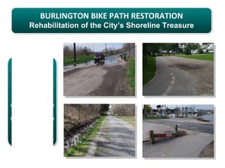
- 1. BURLINGTON BIKE PATH RESTORATION Rehabilitation of the City’s Shoreline Treasure BIKE PATH PUBLIC FORUM Contois Auditorium in City Hall Wednesday, March 14th, 2012, 5:30 – 7:00 pm.
- 2. Evening Agenda 1. Overview of the Process (20 min) Introduction Review of fact sheet Review of evaluation tools 2. Policy Discussion (30 min) General policies Location-specific policies Q&A! 3. Funding Discussion (30 min) Review of packages/costs by segment Funding options Q&A! 4. Next Steps (10 min) Additional Q&A! Contact info
- 3. Fact Sheet… WHAT The City Council passed a Resolution on September 14th, 2010 creating the 12-member Bike Path Task Force and charged it to: Review the current bike path system and the capital needs focusing on the 7.5 miles and its connections to other paths in the network Review the 2002 Feasibility Study and 2005 Island Line Sign & Amenities Plan; make recommendations and revisions Review current maintenance budget and capital budget allocations Identify any financial gaps in the operation budget and future capital budgets Understand how the Bike path is a part of the Island Line Trail and explore opportunities for regional signs, funding and or maintenance Recommend a preferred funding mechanism to address maintenance/capital funding gaps Create a concise written action plan to address funding gaps and Feasibility Study Present findings
- 4. Fact Sheet… WHERE The Task Force was charged with assessing the 7.5 miles of bike path along the shoreline of Lake Champlain, beginning from Austin Drive and ending at the Winooski River Bridge.
- 5. Fact Sheet… WHY The bike path was built 25 years ago and was one of the first in New England. However, it was not built to today's standards and with heavy use and lakeshore impacts some sections are now unsafe and impassable. Yearly repair is no longer a sustainable option for the major restoration and rehabilitation issues. Because the Bike Path is so important to alternative transportation goals, to the health and wellness of our residents, and to the tourism industry in Burlington the City Council created the Task Force with the goals listed above.
- 6. Fact Sheet… WHO As directed by the City Council, the Parks & Recreation Commission appointed Task Force members: Lisa Aultman-Hall John Bossange (Chair) Patrick Standen Jennifer Wallace-Brodeur (Vice-chair) Peter Clavelle Bob McKearin Steve Allen Jane Knodel Will Flender Katherine Monstream Zandy Wheeler Kurt Wright Additional support has come from… Local Motion Department of Parks & Recreation Chapin Spencer, Executive Director Mari Steinbach, Director Deryk Roach, Parks Superintendent CEDO Jen Francis, Parks Planner Larry Kupferman, Director Department of Public Works Chittenden County Regional Planning Commission Nicole Losch, (CCRPC) Bicycle, Pedestrian, & Environmental Planner Peter Keating
- 7. Fact Sheet… HOW The full Task Force has met every other month along with sub- committee work between Task Force meetings. Initiatives and action steps were created to meet the criteria of the Resolution. Consulting engineers, Resource Systems Group was hired to write a feasibility study assessing and recommending necessary projects with accompanying estimates. Public input was received, reports were generated and decisions were made regarding the design, prioritization & restoration processes.
- 8. Evaluation Tools – Prioritization Matrix The Path was divided into sixteen sections and the projects in each section were carefully assessed using the matrix criteria: SAFETY (personal security, traffic security, signs & markings) DESIGN STANDARDS (width & shoulders, surface type, storm water management) CONNECTIVITY (local connections and enhanced access points, community destinations) ECONOMIC VITALITY (visitor information, restrooms, drinking fountains, mile markers) MAINTENANCE EFFICIENCY (utilities, trees & shrubs, cleanliness) Each criteria guideline was given a grade and guideline grades were averaged to develop the overall improvement grade.
- 9. Evaluation Tools – Prioritization Matrix Matrix used to evaluate the 74 specific recommendations in the feasibility study…
- 10. Evaluation Tools – Improvement Spreadsheet An improvement spreadsheet was developed to prioritize each project and summarize costs. Each section was evaluated and broken into three categories: A’s, B’s and C’s + D’s.
- 11. Funding Packages – Three Opportunities Projects were clustered into these three improvement funding packages based on the graded rating system. 1 - Rehabilitation (Comprehensive Rehabilitation) = A’s Preliminary Estimate: $11,645,000 Defined as costs that must be expended to save the bike path and meet the current design standards for sub-base, path width, surface, shoulders and drainage. 2 - Functional (Additional Safety Improvements) = A’s + B’s Preliminary Estimate: $13,875,000 Defined as recommendations that improve safety, add capacity, or improve conditions beyond the existing system including fencing near slopes, lighting in key areas, directional signage, etc. 3 - Enhancement (Additional Amenities) = A’s + B’s + C’s + D’s Preliminary Estimate: $16,873,000 Defined as enhancements to the path’s character and aesthetics including trailhead kiosks, pause places, learning stations, drinking fountains, etc.
- 12. Policy – Recommendations Recommendations were organized in two categories: 1.) general actions that should be taken for the length of the corridor to improve uniformity and 2.) location-specific actions. The recommendations address: Rehabilitating the path to include a wider paved section and unpaved shoulders to improve safety for users and increase the structural ability of the path to accommodate maintenance vehicles. Upgrading the path-roadway intersections to improve safety for all users. Enhancing connectivity to and from the path. Constructing gateways/trailheads to enable visitors to more easily find and navigate the facility. Enhancing the path with a comprehensive suite of amenities such as pause places, wayfinding, and interpretive stations.
- 13. General Policy – Cross-Section The majority of existing path is 8’ wide… with informally developed running paths along each side between 0-2’ wide. The recommended minimum cross-section is 11’ wide… with 2’ of defined unpaved shoulders on either side of the path. A widened (11’) path is the minimum width needed for A widened path will two bicycles traveling in accommodate opposite directions to pass maintenance & emergency one another AND a vehicles. pedestrian (AASHTO).
- 14. General Policy – Cross-Section Associated cross-section (path width) costs…
- 15. General Policy – Path-Road Intersections Each intersection differs and will need to be considered on a case-by-case basis but general elements should be consistent: Right-of-way assigned to vehicles on the road and intersection control is therefore to be applied to the path. Recommended because of seasonal variety of path use and emissions reductions. 4-way stop signs are NOT recommended due to variability of volume. Traffic calming should be applied on the road to reduce vehicle speeds including speed table/raised crosswalk, neck down to 11’ travel lanes and splitter islands. Intersection treatments are based on AASHTO and Intersection control is dictated by sight MUTCD guidelines and standards. distances. The lease intersection control that is effective should be used (that is, ‘yield’ is preferable to ‘stop’).
- 16. General Policy – Connections To improve path’s regional connectivity, the recommendations of the CCRPC Regional Bicycle-Pedestrian Plan and Metropolitan Transportation Plan should be pursued. Locally, consider two issues: 1.) Improving existing connections where gateways should be developed to raise the level of amenities 2.) Defining connections that are currently informal Example gateway treatment at Manhattan Drive The connection behind Burlington College The gap between Starr Farm Road and North Avenue Extension Depot Street Improved access at the Lakeside Avenue bridge staircase
- 17. General Policy – Signs & Amenities The 2005 Island Line Plan, suggested for implementation, includes design and placement recommendations for: Directional and regulatory signs Interpretive markers, Entry/gateway kiosks with interpretive/safety info Pause places Restrooms Benches Sample etiquette signage Bike racks The feasibility study recommends additional enhancement items: Drinking fountains “You are here” maps Trash receptacles Dog waste bag dispensers Signs to existing restrooms Mile markers Directional signage design
- 18. General Policy – Centerline Striping Recommendations: 4” wide yellow striping (broken where it is safe to pass and solid in no passing zones) “Keep Right” pavement markings
- 19. Policy – Location-Specific Map of location-specific recommendations
- 20. Location-Specific Policy – Kiosks & Lighting Gateways & Kiosks: Oakledge Park (gateway & kiosk) King Street to College (kiosk) College Street to Lake Street (gateway & kiosk) North Beach to Little Eagle Bay (gateway) Little Eagle Bay to Shore Road (gateway & kiosk) Starr Farm Road to North Ave (kiosk) North Avenue Extension to Winooski River (kiosk) Pause Places & Learning Stations Oakledge Park Lake Street through Urban Reserve North Beach Lighting Southern portion of the bike path (south of round house point) Waterfront North/Urban reserve Kiosk design North of North Beach
- 21. Location-Specific Policy – Alignment Alignment refers to the bike path’s course and footprint as it passes through an area. Some sections of the path may be considered for realignment to improve safety and user experience. Oakledge Park The tight curve north of the Blodgett Ovens building by Lakeside Avenue The sharp turn North of the water treatment plant to Perkins Pier Between Perkins Pier/Maple Street and College Street
- 22. Policy – Q&A Questions/Comments? General Policy: Cross-section Path-Road Intersections Connections Amenities Centerline Striping Location-specific Policy: Kiosks & Lighting Alignment
- 23. Funding – Review of Packages 1 - Rehabilitation (Comprehensive Rehabilitation) = A’s Preliminary Estimate: $11,645,000 Defined as costs that must be expended to save the bike path and meet the current design standards for sub-base, path width, surface, shoulders and drainage. 2 - Functional (Additional Safety Improvements) = A’s + B’s Preliminary Estimate: $13,875,000 Defined as recommendations that improve safety, add capacity, or improve conditions beyond the existing system including fencing near slopes, lighting in key areas, directional signage, etc. 3 – Enhancement (Additional Amenities) = A’s + B’s + C’s + D’s Preliminary Estimate: $16,873,000 Defined as enhancements to the path’s character and aesthetics including trailhead kiosks, pause places, learning stations, drinking fountains, etc.
- 24. Funding – Costs by Segment Scenario costs estimates by segment…
- 25. Funding – How to pay? Federal Congressional Delegation FEMA shoreline restoration TIGER IV grant application Enhancement grants State Agency of Transportation Bike Path Program Transportation Community Preservation (TCP) Regional/Local Opportunities Chittenden County Regional Planning Commission (CCRPC) TIF District – Waterfront Vermont Community Foundation Private/Corporate Contribution
- 26. Funding – Local Assistance A bond option could be put forward on the November ballot to secure a funding source for the local share. 16.9 Million Bond 20 years / 4% / raises $1,234,000 per year to pay back the bond = about 3 cents on the tax rate This translates to about $75.00 per year on a tax bill for a home assessed at $250.000. 11.6 Million Bond 20 years / 4% / raises $850.00 per year to bay back the bond = about 2 cents on the tax rate This translates to about $50.00 per year on a tax bill for a home assessed at $250.000. 6.7 Million Bond 20 years / 4% / raises $490,000 per year to pay back the bond = about 1 cent on the tax rate This translates to about $25.00 per year on a tax bill for a home assessed at $250.000.
- 27. Funding – Q&A Questions/Comments? 16.9 Million Bond 20 years / 4% / raises $1,234,000 per year to pay back the bond = about 3 cents on the tax rate This translates to about $75.00 per year on a tax bill for a home assessed at $250.000. 11.6 Million Bond 20 years / 4% / raises $850.00 per year to bay back the bond = about 2 cents on the tax rate This translates to about $50.00 per year on a tax bill for a home assessed at $250.000. 6.7 Million Bond 20 years / 4% / raises $490,000 per year to pay back the bond = about 1 cent on the tax rate This translates to about $25.00 per year on a tax bill for a home assessed at $250.000.
- 28. Next Steps – GET INVOLVED! For more information or further discussion, please contact: John Bossange, Task Force Chair (802) 578-7468 or Mari Steinbach, P&R Director (802) 864-0123. Questions & comments may also be emailed to: jsfrancis@ci.burlington.vt.us This entire presentation is available online, along with the full Burlington Bike Path Improvement Feasibility Study. Please visit the Parks & Recreation website for additional details: http://www.enjoyburlington.com/Parks/BikePath1.cfm Thank you for your support in the restoration of our bike path!
Notas del editor
- JOHN
- JOHN
- DERYK
- DERYK
- DERYK
- DERYK
- DERYK
- DERYK
- DERYK
- DERYK
- DERYK
- MARI/CHAPIN
- MARI/CHAPIN
- MARI/CHAPIN
- MARI/CHAPIN
- MARI/CHAPIN
- MARI/CHAPIN
- MARI/CHAPIN
- MARI/CHAPIN
- MARI/CHAPIN
- MARI/CHAPIN
- JOHN/EVERYONE
- MARI
- MARI
- JOHN
- JOHN
- JOHN/EVERYONE
- JOHN