Quality Growth Toolbox Training
•Descargar como PPT, PDF•
1 recomendación•950 vistas

This is Cumberland Region Tomorrow's flagship training manual - the Quality Growth Toolbox
![Cumberland Region Tomorrow’s Objectives are: ,[object Object],[object Object],[object Object],[object Object],[object Object],[object Object],[object Object]](data:image/gif;base64,R0lGODlhAQABAIAAAAAAAP///yH5BAEAAAAALAAAAAABAAEAAAIBRAA7)
Recomendados
Recomendados
Más contenido relacionado
Similar a Quality Growth Toolbox Training
Similar a Quality Growth Toolbox Training (20)
Más de Cumberland Region Tomorrow
Más de Cumberland Region Tomorrow (19)
Último
Último (20)
Quality Growth Toolbox Training
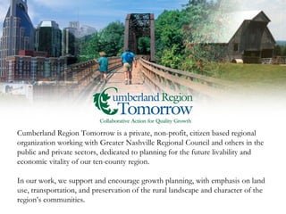
- 1. Cumberland Region Tomorrow is a private, non-profit, citizen based regional organization working with Greater Nashville Regional Council and others in the public and private sectors, dedicated to planning for the future livability and economic vitality of our ten-county region. In our work, we support and encourage growth planning, with emphasis on land use, transportation, and preservation of the rural landscape and character of the region’s communities.
- 6. Prologue: Creating Quality Growth in the Cumberland Region
- 10. Base Case Growth Scenario Cumberland Region Tomorrow Regional Visioning Project
- 12. Alternative Case Growth Scenario Cumberland Region Tomorrow Regional Visioning Project
- 13. Cumberland Region Tomorrow Regional Visioning Project
- 27. Reinvesting in Towns, City Centers, and Communities
- 29. Memphis, TN: Broad Street
- 30. Memphis, TN: Broad Street
- 31. Commissioned by Duncan Associates Memphis, TN: Broad Street
- 38. Example: Bellevue Boulevard / McLemore Avenue Bellevue Boulevard / McLemore Avenue, Soulsville, Memphis, TN: Steve Price, UrbanAdvantage
- 39. Bellevue Boulevard / McLemore Avenue, Soulsville, Memphis, TN: Steve Price, UrbanAdvantage Example: Bellevue Boulevard / McLemore Avenue
- 40. Bellevue Boulevard / McLemore Avenue, Soulsville, Memphis, TN: Steve Price, UrbanAdvantage Example: Bellevue Boulevard / McLemore Avenue
- 45. Creating a Variety of Housing Choice
- 53. Soulsville, Memphis, TN: College Street
- 54. Soulsville, Memphis, TN: College Street
- 55. Soulsville, Memphis, TN: College Street
- 56. Soulsville, Memphis, TN: College Street
- 57. Soulsville, Memphis, TN: College Street
- 58. Commissioned by the Fannie Mae Foundation Soulsville, Memphis, TN: College Street
- 61. New Housing Types to Consider Toolbox pg. 73
- 62. New Housing Types to Consider Toolbox pg. 73
- 63. New Housing Types to Consider Toolbox pg. 73
- 66. Conserving Our Region’s Land, Water, Cultural and Natural Resources
- 84. Transportation and Land Use Planning for Quality Growth
- 91. The region has arterials with redevelopment potential, like this example:
- 92. E14th Corridor - San Leandro, CA Source: Steve Price, Community, Design + Architecture Traditional Arterial…
- 93. E14th Corridor - San Leandro, CA Source: Steve Price, Community, Design + Architecture Arterial with Signal, Streetscape and Pedestrian Modifications…
- 94. E14th Corridor - San Leandro, CA Source: Steve Price, Community, Design + Architecture Arterial with Pedestrian, Bike, and Infill / Mixed-Use Redevelopment…3D’s Applied…
- 98. Source: TJPDC, VDoT, City of Charlottesville, & Albemarle Co. CD+A, Meyer, Mohaddes, & Urban Advantage
- 99. Source: TJPDC, VDoT, City of Charlottesville, & Albemarle Co. CD+A, Meyer, Mohaddes, & Urban Advantage
- 100. Source: TJPDC, VDoT, City of Charlottesville, & Albemarle Co. CD+A, Meyer, Mohaddes, & Urban Advantage
- 106. Develop Context Sensitive Design Guidance Toolbox pg. 149
- 111. McLemore Avenue, Soulsville, Memphis, TN: Steve Price, UrbanAdvantage Example: McLemore Avenue
- 112. McLemore Avenue, Soulsville, Memphis, TN: Steve Price, UrbanAdvantage
- 113. McLemore Avenue, Soulsville, Memphis, TN: Steve Price, UrbanAdvantage
- 114. McLemore Avenue, Soulsville, Memphis, TN: Steve Price, UrbanAdvantage
- 115. McLemore Avenue, Soulsville, Memphis, TN: Steve Price, UrbanAdvantage
- 116. McLemore Avenue, Soulsville, Memphis, TN: Steve Price, UrbanAdvantage
- 119. Guiding Infrastructure Investments for Sustainable Growth
- 125. Toolbox pg. 175
- 136. Example: Develop and Implement Comprehensive Community Plans that Include Infrastructure Provisions Toolbox pg. 180
- 137. Conclusion: Ensuring Our Region’s Economic Vitality through Quality Growth
- 143. Cumberland Region Tomorrow 511 Union St. Suite 1600 Nashville, TN 37219 Office 615-986-2698 Fax 615-986-2697 www.cumberlandregiontomorrow.org Dr. Bridget Jones – Executive Director Office 615-986-2699 Email [email_address] Dave Keiser – Program Director Office 615-986-2698 Email [email_address]
Notas del editor
- Images on Front Cover and Inside page are a blend of the following places in our ten-county region of Middle Tennessee: Left: Downtown Nashville from the Cumberland River, BellSouth, now AT&T “Batman Building”….a Nashville icon building, Riverfront Park and other notable sky line features Center: Bicentennial Walking Train in Ashland City, an excellent example of an urban greenway, featuring stunning views of the Cumberland River, providing biking and walking connections throughout this City Left: A scenic farm in the Leipers Creek community of Williamson County which depicts the beautiful farmland and open areas that make our ten county region desirable and unique.
- Pages 2 and 3 CRT Regional Visioning Project Summary….. Images maps and participant in regional visioning workshops, held in 2001- 2003 across the region Over 500 citizens participated in visioning workshops that produced the Base Case Map (Base Case shows how growth will occur if we don’t do anything differently) and Alternative Case Map (Alternative Case map shows the preference of 85% of workshop participants in guiding our imminent growth in a better way) Regional and state agencies participated in creating Growth Trend Data such as GNRC, TACIR and other noted sources, Fregonese & Calthrope, nation’s best scenario planners employed as consultants RVP findings triangulate with other regional projects across the country and are valid and reliable for regional understanding of growth scenarios and choices
- Page 3 Sidebar Before we consider more detail, consider what RVP research findings were…and what we still consider important today…..
- Pages 2 and 3
- Page 3 and 84 Green areas Open land in 2000 Purple areas Urbanized land in 2000 Yellow, peach and ecru show where growth was predicted to go in the region, if we did not do anything different…..the yellow represents the lowest level of density in primarily agricultural areas Tennessee is currently the 8 th leading state in conversion of prime farmland to residential and other uses…..the Base Case Map depicts this in vivid way with low density residential in our rural areas
- After Regional Visioning Project (RVP) results were released in 2003, communities in our region continue to experience these challenges, with fiscal costs to local governments and fuel costs to residents for community continuing to increase…….
- Page 3 and 170 Alternative Case Map illustrates the preference of 85% of RVP participants and shows the basic tenets of quality growth methods: Return to concentric growth patterns and use of land in existing urbanized areas currently served with existing infrastructure……roads, water and sewer……as well as power and telecommunications… Strategic conservation or our region’s important open lands…..farms, riparian corridors, forests and other natural and cultural features… Combined with making the full use of existing interstates, state and county roads and integrating public transit along existing road and rail routes….. These combined actions can help us to guide growth and development in ways to keep and enhance what residents indicated that they value the most!
- Page 3 This diagram gives us the economic comparisons that are most startling…. … ..¼ of land mass consumed with Alternative Case Scenario, ½ of infrastructure costs, ½ impervious surface created….asphalt the last crop you ever plant…and improved environmental effects, personal time in the car…..change required in development to move to higher density with design to accomplish…. By moving half way between the Base and Alternative Case scenarios, our region can reap tremendous savings and benefits…… The Choice is ours and the time is now!
- Economics of growth and development choices are one of most compelling reasons to act to guide growth in a more desirable way… Infrastructure funding will continue to become more limited and citizens have indicated that they don’t want to pay additional taxes… Utilizing quality growth planning and sustainable development methods will help us make responsible decisions and good use of our public and private financial resources…something that we will all be proud about in coming years!
- What citizens told us they wanted during RVP…and what will insure our regions economic competitiveness for many years to come…………………..
- So how can we accomplish these things….let’s look at the Quality Growth Toolbox and learn more ways to make these things so…..
- Page 1 Image Bicentennial Mall, to the north of our beautiful State Capital Building…..a remarkable example of grey field redevelopment, now one of Tennessee’s most beautiful Urban State Parks……..
- Page 9 Page 6 – 7…..Our region’s perspectives on growth planning is changing….comprehensive plans, aligned with supporting zoning, regulations and codes at the community and regional level….are now beginning to be seen as the foundation of future community and economic development Image and good example…..Gallatin Downtown Master Plan, currently under implementation……..
- Page 9 Image…..West Side of downtown Franklin Square, containing notable historic buildings and great streetscape details…….. Our region is blessed with remarkable, historic town centers such as the Square in Franklin…….. Excellent town and building design make these places unique and highly desirable and provide our region’s diversity of community character…. Use of continued good design will retain and enhance existing and new development and our communities desirability and worth…..
- Page 9 Image….Downtown Columbia Square during annual Bunny Mania Festival near Easter Weekends… Downtown Columbia is now in process of a multi million dollar Streetscape project along Highway 31 and North Main Streets in it’s Downtown Historic Commercial District that will continue the streetscape improvements you see in this image……. These projects along South Garden Street (Hwy 31) and Columbia River Walk (North Main Street) will anchor and encourage continued private and public redevelopment efforts and continued investments in this historic community……
- Page 9 Image…..Live/Work Unit in Pleasant View Village in northern Cheatham County Excellent example of appropriate design and housing choice in this newly developing traditional neighborhood design…type village…..
- Page 9 Image….Clarksville Riverwalk Park on the Cumberland River near downtown Clarksville…….. This park creates urban green space and walkways for residents to enjoy on a daily basis……. Places like this helps us to integrate our region’s natural and water resources into our everyday lives….thus understanding their critical importance and value for our current and future economic, health and social well-being……
- Page 9 Image Maney Avenue Redevelopment Plan near downtown Murfreesboro…case study from Reinvesting Chapter page 28….. Good example of redevelopment of innercity neighborhood focusing on land use and roadway and sidewalk improvements…… By using land use and transportation planning in an integrated fashion, good redevelopment and new development projects will function better and will allow our region to guide growth and development in a more effective manner………
- Page 9 Image……Schermerhorn Symphony Center in SoBro Area of Downtown Nashville…….an excellent example of Brownfield Redevelopment……now one of our Region’s treasures……. When our region’s communities realize and use existing areas of towns, cities and neighborhoods for location of new development….we will see enhanced communities and tremendous savings in land and infrastructure….
- Page 9 Image Music Star Station at Riverfront Park in downtown Nashville… While land use decisions are made at the local level, our region is now recognizing the need for and excellent opportunities in regional thinking and planning for transit, open space, water quality and quantity, and other shared amenities………. Our region’s future livability and economic vitality will be greatly enhances and insured if we all agree to work collaboratively for quality growth and sustainable development………
- Page 10 Images……Long Hunter Park in Wilson County and Historic Downtown Franklin Streetscape……..great depictions of our region’s great land, water and community attributes…. How We Can Do It……Work toward Quality Growth Principles and use the Strategies, Tools and Resources contained in these Toolbox Chapters… After much discussion with 50+ regional leaders, these topics were selected as areas of highest need and greatest opportunity in implementing quality growth methods across our region………. We encourage you to consider how your community can make use of these concepts, tools and resources as you make decisions about the future of your community and our region as we go through this training session today………Thanks for the opportunity to bring this information to you!
- Introduce this as the first topic Briefly discuss that one of the basic principles of quality growth and preventing sprawl is reusing what we already have. But it can be more than just efficient use of land, reinvestment is fundamental to creating thriving and economically vital places. Reinvestment includes: -Redevelopment, -Infill development, -Remediation and reuse of grayfield and brownfield sites, -Revitalization of disinvested areas One way to frame this first topic: Like most American communities after WWII, the Cumberland Region experienced: -Suburban development patterns -Shift of jobs and commercial uses away from the traditional city centers -Advent of auto-oriented land uses, site design and supporting infrastructure (wider, faster roads) As these patterns of growth continue the results have been: -Lack of reinvestment in town centers as buildings and uses become obsolete and convenient new uses are built in outlying areas -Lack of renovation and reuse of older parts of communities Point out successful revitalization efforts such as the Main Street Historic Trust Program (see additional material), and point out local examples of vibrant downtowns or districts (do some homework) Emphasize that there is still a tremendous redevelopment potential in the region, [county]
- Benefits of reinvestment: Emphasize that reinvestment preserves our historic and cultural resources. Benefits to highlight: -Creates a sense of community and helps create unique places with lasting value for the community -Reduces the need to construct new and expensive infrastructure to serve new development (although sometimes existing infrastructure requires renovation and upgrading) -By providing housing and jobs within existing centers, slows the growth of new development in outlying areas. This has positive affects on travel patterns and traffic congestion. -Reinvestment is an important element in creating walkable, mixed-use, compact development, a fundamental tenet of linking transportation and land use.
- This is the first of a series of photo-simulations used in the Toolbox presentation. Describe that simulation is an important tool in planning because it: Helps people envision what could be and visually describes a community vision or goal. Provides a before and after comparison where we lack these examples. Simulation shows how we can take an area of disinvestment, an area lacking vitality and incrementally invest in transportation and infrastructure that guides and encourages private investment in land use. This is an example in Memphis (Broad Street) where lack of economically strong land uses and unwelcoming pedestrian facilities underutilizes the existing infrastructure. Important to give credit to Steve Price of UrbanAdvantage who provided the simulations for the toolbox presentation.
- This slide demonstrates an example of public investment in the transportation system that improves the pedestrian environment, increase on-street parking and sets the stage for private investment. Important to note that the public investments can be implemented incrementally over time and in conjunction with private development. Note that part of reinvesting in town centers is to ensure that the street is designed to complement, support, and become part of the placemaking vision for the area.
- Finally, over time, private investment responds to public investment. Note the important role the design of the street plays in supporting and creating the quality and character of the place.
- This slide provides an overview of the strategies in this topic. There are six key strategies. Explain that you will go into more detail on each of these strategies, and that each strategy is accompanied by a set of tools. Also note the examples of reinvestment shown, and that you will provide more details on one of these examples later in the topic (The Factory at Franklin).
- The strategy is to focus on areas that have the best promise for successful revitalization. These areas serve as catalysts for expanding revitalization and models for how to reinvest in other areas. Boundaries can be defined in many ways…through the development of plans, designation of redevelopment zones, corridors, improvement districts, historic districts, or individual blocks, projects, or buildings. Then focus your resources within this clearly defined area to ensure success
- The success of reinvestment is dependent on a strong plans and policies and implementable regulatory framework. A good redevelopment plan establishes a vision, best developed with the community and stakeholders, and provides clear direction for public and private investments. Direction includes design guidance to ensure that implementation of the plan is consistent with the vision. A good redevelopment plan builds on the community’s unique assets and strengths such as history, and culture. A good plan reflects the community’s values.
- Often reinvestment is oppressed because of burdensome regulatory red-tape, disincentives, and out-of-date planning codes. Removing the barriers not only makes reinvestment possible but encourages it. Common tools include revising the approval process to make it easier to develop consistent with the plan. Change regulations and old zoning to allow what was previously viewed as incompatible or undesirable, particularly higher densities, residential uses where previously prohibited, and mixing uses both horizontally and vertically. Consider developing and implementing a form-based code (see additional material to help describe form-based code) where development is regulated and guided by the design of the streets, sites and buildings rather than land use. Finally, completely revise, or at least modernize codes to allow desirable development and to encourage and incentivize reinvestment. (see additional material on Tennessee incentive programs and for examples of how codes can be updated).
- It is one thing to allow and encourage investment in a community’s vision, it is another thing to provide incentives and actively participate in achieving the vision. There are many tools that serve as incentives, some are listed here. Use your plan to determine which tools are the best for your unique situations, develop incentive programs, then actively promote the incentives. Incentives are not advantageous if noone knows about them. Describe a couple of the incentives, especially those you are familiar with. This is a good opportunity to research on local examples of reinvestment incentives, successful incentive programs and those that have failed. If using examples of failures, make sure you understand why they failed.
- In the Transportation and land use topic we will be explaining the “3 D’s”, density, diversity and design, and how interact to create transportation efficient communities. This slide stresses the design aspect of creating places. The important aspect to emphasize is that good design: Encourages the use of alternative transportation modes, but particularly walking Creates community pride in their centers Supports economic vitality by encouraging people to linger, socialize and explore. Attracts people who normally would not visit, live or work in the community. Design is critical but needs consistent guidance. Design guidelines and special zoning districts establish clear expectations. Good design works best with public/private partnerships. Highlight a few of the tools, but emphasize the importance of developing good design guidelines.
- This is another simulation example from Memphis (Steve Price) illustrating a before condition…
- The types of public investments: Pedestrian enhancements / lighting Streetscape/landscaping
- And finally with private investment in the form of new development built in a manner that creates a more pedestrian and community-oriented development pattern.
- The Context Sensitive approach to planning involves working collaboratively with stakeholders early in the planning process. Emphasize the value of looking “outside the box” for stakeholder that can provide knowledge, history, skills, and support to a revitalization project. Organizations can help… -plan and strategize -finance and implement Use the example of the National Tennessee Main Street Program (see additional information) Local organizations should be involved in the planning stage and throughout implementation. Can consider professional assistance such as charrettes, workshops, and preparation of planning documents.
- This is a list of local, regional and statewide resources that can provide information and assistance with redevelopment, revitalization and preservation.
- Toolbox contains sidebar with this information Emphasize the tools used….. Rehabilitation guidelines, tax credits and local redevelopment incentives Privately purchased abandoned Jamison Bedding property it from the City of Franklin in 1997. Property and buildings were listed on the National Register of Historic Places. Used Department of Interior Guidelines for Rehabilitation and Restoration, Historic Rehabilitation Tax Credits and other redevelopment incentives. Used adaptive reuse principles to transform brown field site into successful center of activity for Franklin and Williamson County. Leases were arranged and renovation of the multiple building complex completed in phases. In 10 years, The Factory at Franklin has used every portion of the property and become a vibrant destination for retail, community services, churches, the arts and housing. Currently a development group is constructing new office and residential space that is architecturally inspired by the factory’s industrial buildings on adjacent properties.
- Page 57 This image is a life cycle of housing diagram that shows the life stages and housing needs that residents of our region go through as they grow up, begin work and a family, finish raising their families and settle into empty nesting…………. Types of housing types and choices needed are also depicted…. Our region does not have all of these housing types and choices in most communities and is not meeting residents life-cycle needs…… Page 60…The way our region can create housing choice is to match housing needs with planning and zoning to ensure that we can create all of the types of housing that we need and want…..and also accommodate our growing workforce……
- Page 58 Housing Trends are influenced by……Sidebar… But the reality in our region is that families are shrinking and the housing that we are building are getting bigger…… A phenomena that we need to address and change for our future livability and economic vitality……………….
- Page 61 Images are infill multifamily near downtown Clarksville and the Stahlman Building on Union Street in downtown Nashville……both examples of new types of housing near the urban center of these communities….. These strategies illustrate a process to identify housing needs of each community, examine current regulations, and expand regulations or create comprehensive plans to create the more housing options…… Also the use of good design to create attractive and functional housing and communities and use of incentives to support the creation of more housing types and choice are also included……………….. Decide what you have, then what you want and need….then use regulations, good design and incentives to make it happen…….
- Page 61….Strategies Images Cherry Hill Cottages in Michigan and Lenox Village attached Duplexes in Nashville Both projects resulted from community awareness of the need for more housing types and choice and the possibility to create them through planning and zoning processes……
- Page 61…Strategies Image….Morgan Park Place in the Germantown Neighborhood near downtown Nashville…..Morgan Park Place was the recipient of a 2007 Governor’s Environmental Stewardship Award for excellence in design…..the first development ever to receive this award….a regional leader in LEED and sustainable site design in our region…….. Also a great example of new types of housing in redeveloping areas where infrastructure already existed……. This development exemplifies each of the Strategies and Tools show on this slide…….
- Page 61 Strategies Images Germantown Garden Court and architecturally compatible in-fill housing along 5 th Street in the Germantown neighborhood…….. These examples show how communities can accomplish this strategy and use the tools noted…………….
- Page 62 Image …inner garden of Germantown Garden Court development showing use of high density housing using good site and building design, use of common open space for rain garden and storm water absorption… Good building and site design drastically improves site and energy efficiency of development and individual homes…each adding up to savings for owners and the community…………….
- So why this topic is important and what we can do about is illustrated in the following slides….illustrating streets in the Soulsville area of Memphis, but looking just like neighborhoods in towns across our region…… Let’s look at our opportunity to create more housing choice and revitalize important areas……..
- This same street, now with public funded streetscape improvements….new sidewalks, lighting, trees and road surfaces……
- Now the same street with new infill housing, sited in accordance with current housing and designed to fit into current architectural styles and housing types……….
- Now the same street with some multi-family housing designed to fit the context of the neighborhood, street and current housing types……
- Now consider this same street, active with residents, and attractive housing and sidewalks…….a revitalized neighborhood with excellent housing choice and value….. Our region and your community has many streets and neighborhoods like College Street in Soulsville……. Think about the possibilities for your community by creating more housing choice in similar areas….the most affordable and desirable housing for renovation is the housing stock that you currently have….
- Pages 69 and 71 Image….5 th & Main Housing Development under construction at the intersection of Main Street/Gallatin Pike and 5 th Street in East Nashville…an excellent example of new infill housing that is affordable and supports planned revitalization of this important arterial entering downtown Nashville….. This and similar developments throughout the region will help us meet our housing needs and support redevelopment efforts in targeted areas……this development was created by Affordable Housing Resources and support through Metro Nashville Planning and Zoning processes……….
- Page 72 Image South Village in Burlington Vermont….designed by Looney Rick Kiss Architects…an approach that has great possibilities in our region… This rural hamlet plan shows Rural Conservation Development Strategies of higher densities with quality design and increased open space conservation…can help our region retain or unique rural feel, while receiving new growth and increased economic vitality….. This approach to site design can reduce the cost of providing housing while at the same time preserve larger amounts of open space and character that residents desire when they decide to live in rural areas of the region…. This type of design also will help us retain and enhance our rural character that is highly desired and valued…….by respecting vernacular architecture, preserving existing vegetation and woodlands, using compatible roads, etc.
- Page 73 Images….Harbor Town near downtown Memphis…..new development that includes housing, retail and commercial and makes areas walkable… Live Work Unit in Pleasant View Village in northern Cheatham County that offers residents to live and work in the same location, often with separate entrances… Werthan Mills in the Germantown Neighborhood near downtown Nashville….an excellent example of adaptive reuse…high density loft style housing…. Example Accessory Dwelling unit in Baywood California…….that have historically allowed extended families to reside on the same property in separate dwellings…..in a large house or off-site in a carriage house or guest house……these are often prohibited…but offer great potential as studios, additional bedrooms or separate apartments………
- Page 75 Images Townhomes and Cottages…Lenox Village in Nashville….these type of homes use alleyways that are often not allowed with street and parking requirements…..by allowing changes to these….this type of highly desirable housing type is possible…. Garden Courts….evolved in large European cities in the 17 th century and now are popular in American cities…modern adaptations include small lot homes or town houses surrounding a green or plaza…..changes to minimum lot sizes make these possible……. Big House or Condos are multifamily units, built like large housing in developments containing similar size units are returns to large homes built in the past to accommodate large families…later converted to apartments…these can accommodate multiple families in suburban areas…
- Pages 67 and 76 Traditional Neighborhood Developments embrace mixed use communities on a compact scale….these often use form-based codes or community design guidelines that ensure that all structures and streetscapes contribute to the mix and design of these areas….the image is Tollgate Village near 840 in Thompson’s Station….one of our region’s newest TND developments… Mixed-Use Housing above commercial is a return to the old tradition of families living above stores or businesses. Many of the lofts in traditional towns like Columbia, Franklin and Clarksville are this type of residential development, that is proving very popular today……..
- Pages 78 and 79
- See narrative in training manual for background and history. (Top Image) Mixed-use development with commercial spaces on the ground level and residential above (2 nd Image from top) An example of a typical street in Germantown. These homes were built after the neighborhood defeated an auto-emissions facility proposed for the site. (Note the on-street parking, landscape buffer and brick sidewalks) (3 rd Image from top) Courtyard-style housing blends seamlessly with the historic homes along the street (Bottom Image) Morgan Park Place, recipient of the 2007 Governor’s Environmental Stewardship Award
- Page 81 – 87 Images Rattlesnake Falls in Maury County, Leipers Fork Farm, Nashville Farmers Market Benefits: Open space, wildlife habitat, water resources and agricultural products Natural beauty and sense of place, Clean and Plentiful Water, Ecologically sensitive areas, Critical conservation lands such as slopes, etc., Quality Places for active and healthily lifestyles, Cultural and Historic Corridors, Agricultural lands and forests Threats: Lands and natural resources depleted if development occurs in poorly chosen locations, with insensitive site designs or under inappropriate construction practices Rapid Conservation of open land to development, Decreasing Ag. Profits and increasing development pressure, State Growth Policies leading to extensive growth boundaries, Traditional development regulations, Creation of impervious surfaces/effect on water quality, Site Development Practices, Wastewater alternatives, Limited intergovernmental cooperation
- Page 88 – 92 Images: Carnton Plantation in Williamson County, Site of Widow of the South novel and creek in Wilson County In order to successfully conserve our region’s land, water, natural and cultural resources in keeping with our current and future needs, a systematic approach to identify areas for conservation and garner resources and efforts to protect them is needed. Strategies in this chapter address this process and offer improved planning for the Natural Infrastructure and conservation development strategies that can help communities and our region work toward these critical needs.
- Pages 90 – 92 Images: Drouillard House in Dickson County and Nashville’s First Green Roof atop Westview Condos on 9 th Avenue in Nashville Great work is currently underway in our region with local and state historic preservation efforts, local and state recreation and greenways work and now with increased interest in Green Building and Construction methods in Nashville and across the region Increasing energy costs and the need to develop locally sustainable energy sources are also underway with the Governor’s Alternative Fuels Initiative which offers great opportunity for the use of our region’s farmland in production of switch grass and other plants for fuel production….an excellent chance for our region’s farm lawn owners to have production outlets for farm products….and a message to us all of how important our open lands are to our future health and prosperity
- Pages 92 – 94 Image: Open field in the Snow Creek Valley of Maury County, the site of The Duck River Highlands Land Resource Study which is an excellent example of a locally led effort to create a tool for use with planning and strategic conservation strategies in northeast quadrant of Maury County
- Page 95 – 102 Image: Project Area Map for The Land Trust for Tennessee’s Loveless to Leiper’s Natchez Trace Corridor Initiative…. This project signifies use of existing tools for conservation such as conservation easements, for strategic conservation efforts in the important view shed corridor along the Natchez Trace in Davidson and Williamson Counties…the yellow highlighted areas show parcels permanently conserved with conservation easements…..
- Pages 103 – 107 Image: Carother’s Crossing development in Davidson County This development illustrates use of Conservation Development strategies. For both rural and urban situations, land and natural resources can be protected by distributing density within an individual property to the sections of the site most suitable for development……while conserving the most valuable land and water attributes……resulting in more highly desired and valuable developments….. Many zoning codes that have minimum lot size requirements, which tend to result in subdivisions with large uniform lots evenly distributed throughout the site….Natural features are less likely to be protected through this approach because large lots convert more land to development…..These regulations make Conservation Development methods illegal and are resulting in the large land consumption patterns, especially in the rural areas of our region…..
- Page 103 – 105 Image: Illustration of streamside forest buffer, offering great site stability and improved water quality This is an example of how natural features and approached can greatly improve the functionality and cost-savings of land development…….through the use of development buffers, and riparian area conservation methods……. Regulations can be put in place to prevent unsafe development practices in sensitive areas. These rules and improved site development practices can play a significant role in protecting our critical land, water, and natural resources throughout our region…….
- Pages 106 – 108 REPLACE IMAGE WITH SIDEBAR ON PAGE 106.. Image: Rural Conservation Subdivision that illustrated distribution of density in relation to important land and water attributes/resources…….. Our region can greatly benefit if we make the right things easy. Updates that streamline regulations, offer bonuses for targeted density and provide opportunities for flexible density within development sites will allow for a wider range of development and also encourage better site development practices….. Another important Tool is Low Impact Development (LID) which is a land development approach that allows for the construction of new homes while conserving natural areas and drainage patterns. The BOB…Building Outside the Box program is a coalition of agencies, non profits, and business interests who have come together to demonstrate and promote sustainable building and restoration practices is an excellent effort underway in the region, using LID and Sustainable Building methods…
- Page 108 Image: Ozburn Hollow Farm in Arrington, Williamson County, est. 1804 is an example of A Century Farm designated by MTSU in our region….. Other Tools and Incentives for this strategy include: Context Sensitive Solutions (CCS) Green Arterial Road Systems Patterning Vernacular Architecture Rural Historic, Cultural and Agricultural Districts Technical Assistance are available from: MTSU Center for Historic Preservation Century Farm and Civil War National Heritage Area Programs Tennessee Historical Commission and Tennessee Preservation Trust TDOT Scenic Byways and Roadscapes Programs
- Page 109 Image: Stones River Greenway near Murfreesboro Efforts to conserve and protect ecologically sensitive areas, critical wetlands, and wildlife habitat are critical to the future success of our region’s economy and community’s quality of life…… To make sure that residents of our region continue to enjoy our land, water and natural resources, we can adopt standards that reduce storm water impacts, establish advantageous vegetation, and protect riparian corridors surrounding our region’s abundant rivers and streams……… Maintaining and re-establishing native vegetation on: Steep Slopes, Flood Plains, Riparian Corridors, Wetlands, Sinkholes, and Developed Landscapes are ways to use Natural Infrastructure practices to our benefit…….
- Page 97 Images: Deer at twilight at Long Hunter State Park and cover of Tennessee State Wildlife Action Plan….the best in the nation….. Our TWRA, Tennessee Wildlife Resources Agency, along with the Nature Conservancy of Tennessee and other partners, have created the SWAP to examine the health of fish and wildlife populations and prescribe actions to conserve wildlife and critical habitat before they become more rare and costly to protect…… The plan identifies in usage GIS to model the most critical wildlife habitat areas including waterways, forests and open lands and caves and threats to their well-being across Tennessee and our region and the species that live in these areas. Of the 37 potential threats identified, the most common cause of wildlife imperilment was incompatible land use practices that result in loss of land, water degradation, and loss of terrestrial and aquatic habitat…
- Pages 110 – 114 Image: Bagby Farm near Adams in Robertson County Our region boasts excellent soils and forests…..valuable resources which have been and continue to be the source of wealth and health for many residents…… Especially now as we reconsider how much we will need local farm land for energy and food production…… Successful efforts to keep agricultural lands open and productive are supported by American Farmland Trust…Planning for Successful Agriculture Strategies that are two-fold: Make farms productive, while, Conserving as much agricultural land as possible……
- Pages 110 – 114 Image: Locally grown produce available at the Farmers Market near the Bicentennial Mall in downtown Nashville…….. Tools and Incentives to Keep Agriculture Viable in our region include: Farm-Related Businesses and Businesses that Supplement Farm Income Agricultural Economic Development Assessments Agri-Tourism Farmers Markets and Community Supported Ag. (CSA) Right to Farm Laws Agricultural Zoning and Agricultural Districts Tennessee Greenbelt Law
- Page 92 Image: Bicentennial Walking Trail in Ashland City…one of our region’s most remarkable urban greenway, connecting most parts of Ashland City along the Cumberland River……. One of the best key support systems is our region’s “Natural Infrastructure”. This is an integrated network of protected land and water that supports native species, maintains natural ecological processes, sustains air and water resources, and contributes to the health and quality of life for our region’s residents and communities…….. Linking and protecting our region’s important open lands through planning for the natural infrastructure will ensure that our region keeps an appropriate amount and balance of land, water, and natural resources to sustain us now and in the future……
- Page 92 Images: Metro Courthouse Square……one of our region’s largest and most beautiful green roof structure and a typical residential rain garden… Currently more and more information exists to help us build and develop in ways that do not cause as much harm or cost to our environment….Innovative communities and companies are using new approached to create sustainable facilities and communities… Some of the more popular methods are listed on this slide……with more innovative methods and materials being created every day….
- See narrative in training manual for further details and background. Land and historic preservation initiative to protect the fragile rural resources of northwest Maury, southwest Williamson, and northeast Hickman Counties. Region is home to small upland farms, historic homes and hamlets, and ecologically rich waterways. Region affected by development pressures from nearby Columbia, Spring Hill, and Franklin. In 2005, concerned landowners approached the Land Trust and raised funds to help formulate a plan for protecting some of the region’s rich assets on a community-wide scale. The first phase of the project involved a year-long inventory study that documented the natural, cultural, historic, and agricultural resources in the region. The inventory staff interviewed residents, surveyed historically important sites and structures, and documented important natural and agricultural resources. Community meetings were held to present the work and explain different land conservation and historic preservation tools local residents can utilize to protect these resources. Project generating a great deal of enthusiasm for land conservation and historic preservation in the community. Inventory highlighted the Duck River Highlands’ many assets, and helped foster a greater appreciation for the region’s scenic landscapes and unique history. The Land Trust for Tennessee is now working directly with the individual landowners and families who gained interest in permanent conservation from the inventory project.
- Point out that this topic is the glue that pulls many of the other topics together.
- Historically transportation planning has responded to land use growth, and since the 1960’s transportation engineers have been trying to keep up with population and employment growth. At the larger scale, linking transportation and land uses requires understanding how land use patterns affect the need for travel, in terms of where land use is located within the region, the type of land use, the design of the land use, and the constraints of the transportation system. When these factors are understood appropriate land use and transportation decisions can be made and can result in a more efficient and sustainable land use/transportation system. At a finer scale, linking transportation and land use means designing streets that are compatible with the adjacent land uses, that support the adjacent “context”, to the point where the street is an integral part of the context.
- Here is why this topic is important: Population and employment growth and growth in traffic is projected to increase sharply over the next 20 years. Funding will fall short of solving the deficiencies in our transportation system. We have rapidly reached a point where “we can’t build our way out of congestion.” In addition we are already seeing impediments to expanding the regional transportation system: Environmental impacts Social impacts Limited right-of-way The effects are not limited to only highways and major arterials, but starts to affec t the livability and desirability of outlying communities.
- Key message: Achieving the tangible benefits of a balanced transportation and land use system requires a collaborative planning approach. Emphasize one definition of sustainability: We want to be able to grow and accommodate new people who desire to live and work in our region and at the same time we want our transportation system to run well and want transportation investments to last a long time….this is sustainability.
- An important concept in understanding how land use influences travel is the 3 D’s, density, diversity and design. Define density and how it influences travel. Key message: Higher densities in the appropriate place and with appropriate urban design can have beneficial impacts on transportation, particularly at the regional scale.
- Define diversity and its affect on travel. Housing choice also accommodates the diverse household types in today’s region. Key message: Not only is mixed use a beneficial land use strategy from a transportation perspective, but it is also a critical element of creating vibrant town centers.
- Define design and its affect on transportation. Key points: There are two primary aspects to design: Urban design features which provides intangibles such as attractiveness, comfort, interest, and encourage to use other than single occupant auto modes of travel. These features include the relationship of buildings to the street and creative a supportive multi modal environment; and Functional design which provides intangibles including accessibility, connectiveness, reliability, security which give people transportation choices , and also allows the chosen transportation system to work effectively and efficiently. Indicate that we will discuss design tools in more detail later.
- Highlight these examples of how the region’s dis-invested and under-utilized arterial streets have redevelopment potential.
- Simulation is one way to illustrate the integration of transportation design into the creation of a place. In this example, the goal of this community is to create a vibrant and economically vital place that has lasting value. This requires a integration of land use, urban design and transportation design and a combination of public and private investments.
- The transportation investment might look like this. It can include vehicle, pedestrian and bicycle safety improvements, and streetscape and landscaping in the public right-of-way. The transportation design helps forms an armature for a place…but is it a place? Not yet.
- It becomes a place when the transportation and land use contexts are combined and integrated in a compatible way. Note how the buildings orient to the thoroughfare and how the privately-owned areas transition into the publicly-owned areas forming a plaza. [Use pointer] The automobile is accommodated, but other modes such as pedestrians, bicycles and transit are equally prioritized. For example, parking is provided in the rear or under the building, separated from the pedestrian realm making the place easily accessible for all users.
- The toolbox contains a varied menu of strategies ranging from regional to community to project-level scales. Combinations of strategies are required to achieved the desired results. Additionally point out that different agencies control and implement different strategies. Important strategy to highlight is the first one. We must make the most out of existing transportation system, squeezing out every bit of efficiency before considering building more roads and widening highways. There will be a day when this will be our ONLY option. The second strategy to highlight is working collaboratively with agencies to coordinate land use and transportation planning. Collaboration is a key aspect of this strategy. This is a good strategy to be illustrated of a local example of a successful development project that work well with the transportation system (e.g., transit-oriented development, mixed-use).
- Strategies to highlight: -Concentrated activity centers are the 3 D’s in practice, these are examples of efficient land use patterns that create efficient travel patterns. -The design of a site can create either an auto or pedestrian-oriented environment simply by how the buildings are oriented to the thoroughfare, how the parking is configured and how well connected the pedestrian facilities are planned. Discuss the features of site design that differentiate auto and pedestrian orientation. Point out that good site design is linked to a previous strategy for Design Guidelines. -Balanced transportation system is a combination of land uses, development patterns and types, and transportation services that create an environment where non-auto travel options are viable and attractive.
- The strategies we just reviewed are supported by a menu of tools. This is the first set of tools, which are applied based on the unique circumstance of the situation. Note that the tools are not specifically related to a particular strategy (like in other topics) but are divided into three major categories: Transportation operations – common and innovative improvements to streets and intersections that improve traffic flow and safety without having to widen streets. Integration of land use and transportation – land use patterns and product types that change people’s travel behavior and designing streets to be more compatible with their surrounding contexts. Design – aesthetic and functional treatments that make alternatives to driving alone viable transportation options. The tools are further identified as applicable at the community and corridor scale or the project scale. This slide lists some common types of operational improvements at the community/corridor scale that improve conditions for auto drivers and pedestrians and bicyclists. (See additional material for some more detail on these types of tools).
- Again using simulation to show how the combination of thoroughfare design, and site and building design evolve an auto-oriented context to a multi-modally oriented context. This simulation demonstrates how the combination can change the context. Current context includes low-intensity and under-utilized land and a basic divided arterial street.
- Collaborative planning includes planning the appropriate density, and type of land uses and transportation improvements that are compatible with the land uses and the type of travel the land uses create. In this simulation the land uses are more intensified, and the street improves the pedestrian and bicycle environment, but remains the primary divided arterial.
- This illustration shows an evolution into a town center. Note that the street is reduced in size and more pedestrian-oriented (an example of a road diet). This can occur when increase street connectivity occurs with redevelopment, allowing traffic to disperse over a grid of streets.
- Additional tools at the community and corridor level. A few interesting ones to discuss include: -ITS (intelligent transportation systems) and how this use of technology can improve traffic conditions without widening streets or highways. -Plan for Bus Rapid Transit – often used in lieu of building expensive light rail systems, a modern bus transit system that provides many of the same benefits of light rail at a fraction of the cost. (see additional material for a more in-depth information). -Access management – an excellent way to squeeze more capacity out of streets without widening and to improve aesthetics and pedestrian safety (see additional material).
- These tools tie back to other topics and are the actions that make strategies work. Discuss those topics that would be of particular interest to the community you are presenting to, but the default should include: -Adopt design guidelines (this would be a good topic for a handout, an example (best if local) of a good set of guidelines for street design). -Consider an adequate facilities ordinance (see additional materials for more information).
- The menu of design tools covers a very broad spectrum of issues, from development patterns, to housing development types to mixed-use, to landscaping and urban design, to street network, and street design. From a transportation perspective, the primary benefit of good design is choice…choice in where to live and work, and choice in mode transportation. But good design has many benefits some of which are listed here.
- One of the most important factors in creating a walkable place is connectivity. The single greatest barrier to walking is a lack of connectivity. Before the automobile communities used to be quite walkable, but development patterns changed and land uses became separated served by an auto-centric transportation system. Describe the difference in the north and south areas of the diagram, note that north area has segregated land uses with little connectivity between them (forces everyone onto the arterial street), whereas area to the south mixes land uses and provides an interconnected street system with many choices to get from point point to point without using the arterial. Some communities are developing connectivity plans, or at a minimum, are preparing connectivity guidelines for new development. Other tools to highlight: -As downtowns and town centers become more vital, the need to develop comprehensive public parking strategies and programs. As areas intensify, communities may want to treat parking as a commodity. -Some incentives for different types of development (such as higher density housing, mixed-use and TOD) include innovative parking strategies which begins with revising old parking standards to be more flexible. Also as areas intensify the need to protect surrounding residential neighborhoods form traffic and parking intrusion becomes more apparent, so these tools might include neighborhood traffic management plans.
- More design tools: Integrating transit means to orient sites and buildings towards the street served by transit (its good to orient towards the street even if it is not served by transit), and to provide a transit stop (with amenities) at development projects of the appropriate scale and type for transit (e.g., high density housing, employment). On larger sites ensure that all of the buildings have convenient pedestrian connections to transit. Discuss the different types of development types. See additional information for handouts and additional information.
- Regardless of whether you are developing a single project, a comprehensive citywide plan, or a new transportation facility there are significant benefits to using a process involving Contest Sensitive Design (CSD). CSD recognizes that achieving Trans and LU integration requires different roadway designs depending on the land use character. Discuss the tenets. The CSD process produces positive outcomes that include: Stakeholder and agency education Full range of alternatives Enhancements to community, environment and transportation Clear assessment of trade-offs so that informed decisions can be made Innovative solutions Public trust and credibility in agency Community ownership in decisions CSD is both a process and a way of designing balanced multi-modal transportation facilities that respect traditional objectives for safety, efficiency, capacity, and maintenance, while integrating community objectives and values relating to compatibility, livability, sense of place, urban design, cost and environmental impacts
- A key to CSD is understanding what is meant by “context”. One definition is: The nature of the natural or built environment created by land, topography, natural features, buildings and associated features, land use types, and activities on property adjacent to streets and on sidewalks and the broader area created by the surrounding neighborhood, district or community. Context also refers to the diversity of users of the environment. A simple way to identify context is to use something similar to the “transect” developed by the new urban architect and planner Andres Duany. This system takes the infinite spectrum of natural and built environments and classifies them into six discrete context zones intended to correctly identify supportive characteristics. Often times these context zones can be used to develop context-specific design guidance.
- See additional material for the key aspects of pedestrian-oriented building and site design.
- Good design is based on an understanding of human needs. There are a number of tools for good site design including the appropriate types or mix of land uses, oriented the building toward where people approach instead of parking lots, creating pedestrian-oriented setbacks, not auto-oriented, small blocks that encourage walking, putting parking in structures or behind or to the side of buildings, and avoiding projects that create unwelcoming frontages and poor access to other uses or transportation facilities.
- The design of buildings plays an important role in how people perceive a community or district. The design of buildings is very important from the pedestrians viewpoint because it adds visual interest, identifies entries, provides street-level activity and socializing opportunities. A “streetwall” of buildings provides a sense of enclosure that makes walking more comfortable when in urban areas. NOTE that we are not talking about architectural design but rather urban design and creation of public space.
- Another simulation…describe existing conditions, older area with a theater that has potential for significant activity. Located in area with lack of investment.
- Area with streetscape improvements.
- Catalyst development project such as renovation of a historic structure start to draw interest to the area.
- ..and draw new development into the area.
- Over time the area become vibrant and economically vital.
- This transformation can occur very efficiently with application of the right strategies and tools with public investments and incentives to encourage complementary private investment.
- This is a list of local, regional and statewide resources that can provide information and assistance with land use and transportation planning, as well as provide information on design and Context Sensitive solutions.
- Case Study Background – This is an example of an ongoing “Major Investment Study” which integrates land use and transportation planning. The Nashville region is experiencing substantial growth. From 1990 to 2005 the growth rate for the five county region of the Metropolitan Planning Organization (MPO) was 35%. Existing transit services within the five-county Nashville region are primarily limited to local bus systems with some express service to the Nashville CBD. There is an extensive car/van pool system within the region. The Music City Star commuter rail service began revenue operations in 2006. This commuter rail, links Lebanon, TN with downtown Nashville. This is the region’s first corridor of a multi-modal, regional system that was planned to parallel many of the area interstates. As part of this multi-corridor transit network, the MPO, in coordination with the Regional Transportation Authority (RTA) and the Nashville Metropolitan Transit Authority (MTA), began a study in 2004 to evaluate the potential for establishing a high-performance transit connection to Murfreesboro. Increasing capacity on other regional roadways has not been as successful in keeping up with demand. The Northeast corridor has stood out in terms of potential ridership and favorable air emission reductions. This study is unique for the region in that alternatives for both land use and transportation will be studied together rather than as separate entities. The objective of this study is: - Investigate current mobility condition in the Corridor, both technically and as a perception of the residents and businesses who use the corridor regularly. Develop a series of alternative growth patterns, starting with the pattern envisioned by the local governmental entities and proceeding through an iterative process to produce a transportation system that delivers the best level of transportation service to fit the desired land use pattern. Study evaluates existing unconstrained development pattern and a series of alternative land uses and corresponding transportation systems, culminating in a set of land use and transportation choices selected by the Corridor. Study will also result in recommendations for local land use policies to ensure the desired land use patterns will be implemented.
- Page 157 Image: Natchez Trace bridge over Hwy 96 West in Williamson County As this toolbox makes clear, many factors influence land use and development patterns…..community reinvestment vs green field development, home building patterns, land use and transportation planning – best used if worked together and other quality of life issues including conservation of open space…….This chapter looks at another important facet of growth and development….providing adequate infrastructure…. Infrastructure represents sizable capital investments in facilities and equipment and substantial commitments of land and other natural resources to accommodate it…whether it be roads, water and sewer, telecommunications or other utilities…. Our region’s continuing growth rate will require new and improved infrastructure….and both are Costly…...Coordination of these investments with all other factors explored in this Toolbox is essential……..
- Pages 168 – 169 Image: Typical roadway, and sewer infrastructure along a Greenway….. Five of our region’s ten counties….Davidson, Williamson, Rutherford, Sumner and Montgomery…account for almost a third or $6 Billion of the entire states infrastructure needs…..no coincidence that these are among our region’s fastest growing counties…… Funding to meet these needs will need to come from all levels of government, utility providers and the private sector and funds are limited at every level…… Local government’s ability to provide for this is challenged with traditional low density development patterns the loss of federal infrastructure funding and other state priorities…..It is imperative that we coordinate development decisions with public and private infrastructure funding to meet our region’s growing needs in a responsible manner….Coordinating comprehensive plans and infrastructure investments can make our region sustainable and competitive….and keep costs of government/taxes at acceptable levels…
- Pages 170 – 171 Images: CRT Alternative Case Scenario and typical Commercial Construction Site in our region….. Residents of our region stated that they preferred growth patterns in keeping with our Alternative Case Map….with defined areas of growth in nodes and along corridors set within areas of relatively undeveloped land… Uncoordinated land use and transportation planning and provision of infrastructure by many providers such as local governments, utility districts, state agencies and other providers will not guide our region’s growth toward the Alternative Case….This lack of coordination coupled with premature, dispersed development patterns in some areas creates unanticipated infrastructure needs…The resulting large costs suggest that strategies and tools to improve coordination is needed….. Development of comprehensive local, project scale and ultimately regional plan, coupled with guided infrastructure investments is one way to proactively accomplish get a handle on this critical issue….
- Page 174 – 179 Image: Berry Farms Development Comprehensive Site Plan Guiding infrastructure and resulting growth can help provide predictability, affordability and sustainability for our region…..We can do four basic things to support our region’s vision and guide infrastructure investments: Guide growth and development to ensure cost-effective investments Invest in infrastructure that supports the kind of communities and open space that residents of our region value and desire Align priorities and programming to create and maintain cost-effective infrastructure investments that will lead to cost-effective government Increase our information base for more informed planning and infrastructure decisions
- Pages 178 – 179 Image: US Highway 321 SR 73 Improvements near Gatlinburg This project is an example where local and state governments planned for for Regional Economic Development Readiness by making sure this important gateway into Gatlinburg and the Smoky Mountains was attractive and functioned well to move cars and people. By identifying the most attractive locations for economic development and making sure sites and communities are ready…… Employers desiring to locate, expand or remain in our region can invest with confidence…and We look like we know what we are doing by making sure that we have infrastructure and sites ready across the region…. For support of all economic sectors, regional Jobs/Housing Balance and equal benefit to all counties….
- Page 173 TDOT Plan is Tennessee’s Multi-modal Transportation Plan, geared to identify and meet the state’s transportation needs for the next 25 years. Plan Go accomplished three important outcomes: A 25-year vision for transportation in Tennessee A 10-year Strategic Investment Plan, consistent with the Vision An annual development of a 3-year program of projects approved by the Legislature Important outcomes of Plan Go in addition to a vision for transportation services for the next 25 years are: Highest priority put on preservation of infrastructure, transportation services and safety Need to invest in all modes and create sustainable long-term funding for all facets of transportation in Tennessee Process to evaluate projects that best meet community needs and prioritize them consistently with the Plan’s Guiding Principles
- Page 180 Image: Streetscape Improvements in Nashville’s 12 South Redevelopment District Comprehensive Planning including adequate infrastructure is the foundation for effective community and economic development…….they also are our assurance for sustainable and cost-effective government…. Strategic infrastructure investments can support our region’s Quality Growth Principles, Goals and Strategies….and Improve local tax bases by leveraging existing infrastructure to increase community property value and tax bases…. When all essential elements of community and economic development are addressed in comprehensive plans and connected to infrastructure planning and funding, our region can insure that we have economic development readiness and preserve our great quality of life….and also maximize our public and private investments…….
- Page 175 Image: Downtown Streetscape with improved roads, parking and pedestrian areas…. Capital Improvement Programs (CIP) can align with comprehensive community and regional plans, with provisions to have development concurrent with development they can encourage development in the right place at the right time….. Consolidated information form CIP’s can support informed decisions regarding planning and infrastructure investments and greatly assist governments in ensuring cost-effective operations…… And ensure that older infrastructure is updated properly for on-going operation and safety……and not over looked by pressing new infrastructure demands from dispersed development patterns…… A current state and national issue………..
- Page 176 Sidebar Image; Nashville Chamber Partnership 2010 Regional Infrastructure Priorities… The Partnership 2010 Strategic Plan, Goal Area 4, calls for emphasis on regional infrastructure planning and development as essential to continue our regional economic development success by ensuring that we have an adequate range of sites to locate new or expanding employers throughout all ten-counties… Identifying the most appropriate for these new jobs, with those equipped with necessary roads and other transportation modes such as air, waterways and rail support; along with water, sewer, telecommunications and other utilities; is key to maintaining our region’s continuing economic development success… By working proactively to identify and prepare our best sites for economic development within community and regional plans, we will be ready for continuing economic development that is sure to come and that we all desire……
- Page 177 Sidebar Image: Commuter Patterns in our ten-county region…. The dispersed and one dimensional pattern of growth over the past 30 years has over the last 15-20 years have seen concentrations of jobs in Davidson, Rutherford and Williamson counties and movement of employees to other counties across our region, as this graphic illustrates….. This pattern of growth has created increased congestion as workers drive across county lines for work, shopping and other daily activities, even as our interstates and roadways have been expanded…. A broader regional view of economic development can foster a better balance of jobs and housing across our counties and reduce infrastructure costs…and also ensure a jobs/housing balance that insures workforce housing near job centers that is a good spatial match between skills needed, housing choice and accessibility to work….Quality infill and redevelopment with diverse housing at varying density levels is one way to meet this regional need and make the most of our existing infrastructure investments……
- Page 178 PC 1101 is the state’s guide for comprehensive planning and can be strengthened by: Defining comprehensive plan requirements Requiring coordination with local plans required in Title 13, the state’s primary legislation Integrating plans with non-state and federal infrastructure funding Requiring coordination with state governmental plans, programs or policies
- Page 179 Counties and cities in our region can elect to exceed current requirements: Develop comprehensive community and regional plans tied to community and economic development priorities Align Infrastructure funding/operation to implement comprehensive plans Connect Comprehensive Plans to PC 1101 Plans submissions Use PC 1101 Joint Economic and Community Development Boards to coordinate county wide comprehensive planning, with infrastructure funding included, to ensure economic development readiness
- Page 182 – 185 Priority Funding Areas for public infrastructure investments guide development into designated areas and away from areas identified for conservation “ Fix it First” Policies maximize use of existing infrastructure in already developed areas. Examples of program and phasing tools that can insure sustainability and cost-effective government are: Making roads work for multi-modal uses Downtown revitalization using and repairing critical internal works Congestion management tools like ITS (Intelligent Transportation Systems) Concurrency requirements tieing development approvals to specified levels of infrastructure Asset Management manages capital assets and minimizes the costs of owing and operating then Incentives for large developments provide wider range of housing types and density bonuses in return for development meeting certain criteria…coordinated master plans and infrastructure installation is critical to the success of such projects
- Pages 186 – 187 Use Asset Management and CIP for wise financing and investment decision making….and insure system efficiency and long-term costs of operation and maintenance…..when Greenfield development is standard practice, older inner systems pipes and roadways are often left behind as funding goes to support new systems for dispersed development patterns Maximize Grants - When federal, state and local infrastructure funding is coordinated with comprehensive plans, grants can be more successfully obtained and government expense can be more effectively managed Establishing Infrastructure Tax Credits can encourage builders and developers to invest in neighborhoods that have existing or planned infrastructure in municipalities designated as growth centers Integration of Land Use and Transportation and Infrastructure Funding by states provide strong incentive by specifying a set of criteria for inclusion in local land use plans that address integration of transportation impacts and assumptions as a prerequisite for state funding
- Page 188 – 191 Traffic Impact Analysis consider identifying onsite and offsite road improvements required by developments….these are done best when they include area-wide capacity and tie to variable LOS targets to induce development that is contiguous and urbanizing Cost of Community Services Studies (COCS) provides counties data that can be used to understand the cost of services on a county scale…..The methodology analyzes revenues and expenditures on a land use basis…residential, commercial/industrial, and farmland for a specific year. The analysis presented above is COCS results from a 2005 study completed in Robertson County which documented revenues by land use categories and fiscal demands of public services (ie… public safety, government, administration, schools, courts, etc). Results provide local government decision makers a snapshot in time description of the net cost to local county governments by land use types for a particular fiscal year Generally COCS results call for a balanced approach to land use planning and decision making that includes an appropriate mix of land uses to even out costs to local governments and tax payers
- Case Study details in Toolbox Training Materials Section for this chapter
- Page 195 – 197 Image: Trailhead of Nashville Greenway at Union Street, following Riverfront Park in downtown Nashville At CRT, we think that our region’s economic success is supported our region’s tremendous quality of life, provided in great measure by our quality places…..unique communities and beautiful landscapes…..providing an incredible range of lifestyle choice…. These attributes will sustain our region’s long term economic competitiveness…. We believe that we can maintain and improve our unique communities and beautiful landscapes that are the basis of our quality of life…our differentiated product….and accommodate the rapid growth that is sure to come…At CRT we believe that far from being competing goals, economic development is actually predicated on quality growth and sustainable development…..Our approach must seek balance….With collaborative action, education and hard work our region can remain the great place it is today…..
- Page 198 – 201 Image: Church Street in downtown Nashville, showing new streetscape, Viridian and planned Signature Tower in-fill housing projects Support All Economic Sectors through Quality Growth: Corporate Headquarters, Manufacturing and Professional Services Building/Development/Real Estate/Finance Retail/Commercial Tourism/Recreation/Entertainment Agriculture Government Guide Growth for Economic Development Readiness and Quality of Life Comprehensive view that balances growth with community improvements and economic development readiness…sites, workforce, housing, prepared infrastructure, sound government…….. Make Possible a Range of Quality Design and Development
- Page 202 -207 Images: Roxy Theatre in downtown Clarksville and Narrows of Harpeth Park in Cheatham County Comprehensive Plans are the foundation for successful economic and community development…we will discuss these in the Case Study in this Chapter….. In order to successfully put local and appropriate regional plans in place, we must Provide Resources to Create Comp. Community and Regional Plans…..Matching grants, Planning T/A through qualified consultants, T/A staff to provide additional help in comp. planning, design and other technical areas…. Update the Rules to Allow Quality Growth and Sustainable Development…..Topics in Toolbox, Engage and Educate Citizens and Leaders, Update Plans-Zoning-Regs-Codes, Design and Development System for outputs to create region we all desire Use Public and Private Funding to Implement Comp. Plans Use Redevelopment Incentives to Catalyze Investments Encourage Regional Planning Where Appropriate Create Mechanisms for Regional Collaboration
- Images on Front Cover and Inside page are a blend of the following places in our ten-county region of Middle Tennessee: Left: Downtown Nashville from the Cumberland River, BellSouth, now AT&T “Batman Building”….a Nashville icon building, Riverfront Park and other notable sky line features Center: Bicentennial Walking Train in Ashland City, an excellent example of an urban greenway, featuring stunning views of the Cumberland River, providing biking and walking connections throughout this City Left: A scenic farm in the Leipers Creek community of Williamson County which depicts the beautiful farmland and open areas that make our ten county region desirable and unique.