

Recomendados
Más contenido relacionado
La actualidad más candente
La actualidad más candente (20)
Destacado
Destacado (15)
Similar a Planning of jaipur
Similar a Planning of jaipur (20)
Más de ctlachu
Más de ctlachu (20)
Último
Último (20)
Planning of jaipur
- 2. Reasons for Maharaja Sawai Jai Singh to change his capital from Amber to Jaipur • Military Reasons • Geographical Reasons
- 3. Two significant facts responsible for the origin of the city and its subsequent layout • The need of a new capital for 18th century Dhoondhar as the earlier one of Amber built on a hill was getting congested. • Sawai Raja Jai Singh’s vision of the new capital as a strong political statement at par with Mughal cities and as a thriving trade and commerce hub for the region.
- 4. • The layout of the city of Jaipur wonderfully links the concept of a Shastric city with the practicalities of the chosen site. • First, the straight line of the ridge suggested itself as the route for one of the main east-west thorough fares and building a road along its crest makes best possible use of the topography for the purpose of drainage. • What followed then was to regularize the Amber-Sanganer road as a north-south route at right angles to it. • The point of intersection would be one of the city’s main cross- roads (chaupar)
- 5. • The southern boundary of the city had to lie within the line of the Agra-Ajmer road. So by extending the NS road as far as possible southwards gives the first fixed dimension, the length of a side of a square and so establishes the size of the unit or module of the city. • A road cutting the plain from N to S linking Amber,the capital to Sanganer, the principal trading town. This road had to be preserved and controlled and therefore had to fall within the city’s boundaries • A second road ran E to W between the Mughal cities of Agra and Ajmer and placing the new city on this already established communication line would help secure its economic success. However since this was an imperial road that could not be encroached on, thus the city had to be contained to the north of this line.
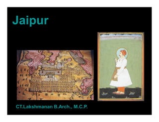
- 8. • The central axis of the town was laid from East to West between the gates of the Sun(Suraj pol) and the moon(Chandpol) • This was crossed by two roads at right angles dividing the town into nine almost square, almost equally sized blocks, which were further sub divided by lanes and alleys all at right angles.
- 9. • The palace building covered two blocks, the town six and the remaining ninth block was not usable on account of steep hills. So this North- West ward was transferred to the South- East corner of the city, making the shape of the plan as a whole asymmetrical rather than square.
- 10. • The city’s division into nine wards was also in conformity with the Hindu caste system, which necessitated the segregation of people belonging to different communities and ranks. • Following the directions of the Hindu Shilpa shastra, width of the main streets & other lanes were fixed. Thus the main streets of the city were 111ft. wide, secondary streets 55 ft. wide & the smaller ones 27ft. wide.
- 11. • South of the main road were four almost equal rectangles. • The rectangle opposite the palace has been broken up into two equal and smaller rectangles by the Chaura Rasta. Thus altogether there are now five rectangles on the south of the main road called Chowkris. • On the North of the main road from West to East are the Purani Basti, the Palace and Ramchandraji
- 12. • Jaipur is known as the Pink City, a rather idealized description of the terra-cotta-colored lime plaster that coats the old part of the city's walls, buildings, and temples. • The reasons for painting the town pink are unknown, but various theories have been tossed about, from using pink to cut down glare, to Jai Singh II's apparent devotion to Lord Shiva (whose favorite color is reputedly terra cotta). • Others believe Singh wanted to imitate the color of the sandstone used in the forts and palaces of his Mughal emperor- friends. • The most popular reason (spread no doubt by "Britishers" during the Raj era) is that pink is the traditional color of hospitality, and the city was freshly painted and paved with pink gravel to warmly welcome Edward VII for his visit here in 1876
- 13. CONCEPTUAL PLAN - CHAUPAR • CHAUPAR – It’s a square that occurs at the intersection of east west roads with three north south roads. Each chaupar is around 100m x 100m. Were used for public gathering on festive occasions. The distance between two chaupars is about 700m which is ideal for pedestrian movement. It has controlled façade treatment enveloping it
- 14. BAZAARS • Originally only four bazaars were planned for the city. These were later named as Johri bazaar, Sireh Deori Bazaar, Kishan pole Bazaar & Gangori Bazaar • On the main streets strict control was exercised on the street façade, along which were located shops and arcades- one storey high, but beyond the frontage the buildings could be of any height or any shape, some built with flat roofs & others with traditional chattris