Enviar búsqueda
Cargar
CycleStreets presentation to Cambridge Geek Night (3rd August 2010)
•
0 recomendaciones
•
759 vistas
CycleStreets
Seguir
Denunciar
Compartir
Denunciar
Compartir
1 de 45
Recomendados
CycleStreets presentation to Society of Cartographers
CycleStreets
Putting Nottingham on the Map
SK53
Webinar: Planning, design, implementation and operation of the Yichang BRT co...
BRTCoE
Integration of Land Use & Transportation Planning in the SMART Plan
Miami-Dade Transportation Planning Organization
Dotnet t-drive enhancing driving directions with taxi drivers’ intelligence
Ecway Technologies
Webinar: Using smart card and GPS data for policy and planning: the case of T...
BRTCoE
DfT data
DfT data
CycleStreets
CycleStreets main presentation to OSM State of the Map 2009
CycleStreets
Talk: "Using Open Data and Crowdsourcing to develop CycleStreets"
CycleStreets
CycleStreets quickfire presentation to OSM State of the Map 2009
CycleStreets
CycleStreets: Our Story - presentation to Net2Camb event
CycleStreets
England Cycling Data Project
CycleStreets
Cycle City Leeds - mobile wayfinding
CycleStreets
CycleStreets: Past, present and future
CycleStreets
SoTM US Routing
SoTM US Routing
MapQuest
GeOng presentation about OpenStreetMap
chippy
An analytical advantage - using data to reduce lap times
David Carson
Volunteered Geographic Information and OpenStreetMap
chippy
OpenStreetMap and CycleStreets: collaborative map-making and cartography in t...
CycleStreets
OpenStreetMap Brighton 0.9999
mikel_maron
Mapc Data Day 7 15 09
aleda_freeman
OpenStreetMap - The Quality Issue
CASA, UCL
Using ArcGIS to Propose an On-Street Bicycle Network
Bryan Townley
TEVIS 100 Mile Ride
TEVIS 100 Mile Ride
janice sutherland
Making an Orienteering Map in Seven Basic Steps
Gord Hunter
Transport mapping: The OSM Route
Harry Wood
Tokyo April 2008 Openstreetmap
chippy
7A_2_Preliminary results of a spatial analysis of dublin citys bike rental sc...
GISRUK conference
CycleStreets - more than a router (State Of The Map 2013) #sotm13
CycleStreets
Maps, mashups and metadata:geospatial standards for access and retrieval
Scottish Library & Information Council (SLIC), CILIP in Scotland (CILIPS)
Más contenido relacionado
Destacado
Talk: "Using Open Data and Crowdsourcing to develop CycleStreets"
CycleStreets
CycleStreets quickfire presentation to OSM State of the Map 2009
CycleStreets
CycleStreets: Our Story - presentation to Net2Camb event
CycleStreets
England Cycling Data Project
CycleStreets
Cycle City Leeds - mobile wayfinding
CycleStreets
CycleStreets: Past, present and future
CycleStreets
Destacado
(6)
Talk: "Using Open Data and Crowdsourcing to develop CycleStreets"
CycleStreets quickfire presentation to OSM State of the Map 2009
CycleStreets: Our Story - presentation to Net2Camb event
England Cycling Data Project
Cycle City Leeds - mobile wayfinding
CycleStreets: Past, present and future
Similar a CycleStreets presentation to Cambridge Geek Night (3rd August 2010)
SoTM US Routing
SoTM US Routing
MapQuest
GeOng presentation about OpenStreetMap
chippy
An analytical advantage - using data to reduce lap times
David Carson
Volunteered Geographic Information and OpenStreetMap
chippy
OpenStreetMap and CycleStreets: collaborative map-making and cartography in t...
CycleStreets
OpenStreetMap Brighton 0.9999
mikel_maron
Mapc Data Day 7 15 09
aleda_freeman
OpenStreetMap - The Quality Issue
CASA, UCL
Using ArcGIS to Propose an On-Street Bicycle Network
Bryan Townley
TEVIS 100 Mile Ride
TEVIS 100 Mile Ride
janice sutherland
Making an Orienteering Map in Seven Basic Steps
Gord Hunter
Transport mapping: The OSM Route
Harry Wood
Tokyo April 2008 Openstreetmap
chippy
7A_2_Preliminary results of a spatial analysis of dublin citys bike rental sc...
GISRUK conference
CycleStreets - more than a router (State Of The Map 2013) #sotm13
CycleStreets
Maps, mashups and metadata:geospatial standards for access and retrieval
Scottish Library & Information Council (SLIC), CILIP in Scotland (CILIPS)
What to do when Classic Google Maps Go Away?
msz
LSxCafe Swtich2OSM.org talk
chippy
Gps general-training-and-software-applications-kuala lumpur-nov-2018
Harshali Mane
Dynamic Fleet Sizing Problem for an E-Scooter Valet Service
Joseph Chow
Similar a CycleStreets presentation to Cambridge Geek Night (3rd August 2010)
(20)
SoTM US Routing
SoTM US Routing
GeOng presentation about OpenStreetMap
An analytical advantage - using data to reduce lap times
Volunteered Geographic Information and OpenStreetMap
OpenStreetMap and CycleStreets: collaborative map-making and cartography in t...
OpenStreetMap Brighton 0.9999
Mapc Data Day 7 15 09
OpenStreetMap - The Quality Issue
Using ArcGIS to Propose an On-Street Bicycle Network
TEVIS 100 Mile Ride
TEVIS 100 Mile Ride
Making an Orienteering Map in Seven Basic Steps
Transport mapping: The OSM Route
Tokyo April 2008 Openstreetmap
7A_2_Preliminary results of a spatial analysis of dublin citys bike rental sc...
CycleStreets - more than a router (State Of The Map 2013) #sotm13
Maps, mashups and metadata:geospatial standards for access and retrieval
What to do when Classic Google Maps Go Away?
LSxCafe Swtich2OSM.org talk
Gps general-training-and-software-applications-kuala lumpur-nov-2018
Dynamic Fleet Sizing Problem for an E-Scooter Valet Service
CycleStreets presentation to Cambridge Geek Night (3rd August 2010)
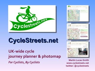
1.
CycleStreets.net Martin Lucas-Smith
www.cyclestreets.net twitter: @cyclestreets UK-wide cycle journey planner & photomap For Cyclists, By Cyclists
2.
What is it?
Cycle journey planner Online service Photomap Campaigning tool System of two parts:
3.
CycleStreets: who? Simon
Nuttall Routemaster Martin Lucas-Smith Webmaster … and various people helping out in various ways!
4.
5.
6.
CycleStreets: UK-wide
7.
Journey Planner
8.
Nominatim namefinder +
postcodes
9.
Gives Fastest, Quietest,
Balanced, (+ shortest)
10.
11.
Route feedback goes
to OSM contacts
12.
Route feedback goes
to OSM contacts
13.
‘ Flyover in
Google Earth’ feature
14.
Routing documented
15.
16.
17.
18.
19.
Conversion from OSM
20.
Conversion from OSM
21.
Provision Types –
as used by the engine
22.
23.
24.
25.
26.
27.
28.
29.
Photomap: cycling photos
on map
30.
Photomap: cycling photos
on map
31.
Upload photo /
video / Flickr import
32.
Photomap: add categorisation
data
33.
Photomap: add categorisation
data
34.
Photomap: categorisation
35.
Listings e.g. “All
cycle parking problems in Cambridge”
36.
Photos en route
37.
Other features: RSS
feed, Galleries, More photos near here, My journeys, Info about this area page, Search, XML interface etc.
38.
http://cambridge.cyclestreets.net / journey/YorkStreet/
39.
http://cambridge.cyclestreets.net/ journey/YorkStreet/DowningPlace/
40.
41.
42.
43.
44.
45.