Comenius 2008-A régió bemutatása
•Descargar como PPT, PDF•
0 recomendaciones•254 vistas


Recomendados
Más contenido relacionado
Destacado
Destacado (9)
Más de Debreceni Bethlen Gábor Közgazdasági Szakközépiskola
Más de Debreceni Bethlen Gábor Közgazdasági Szakközépiskola (16)
Último
Último (20)
Comenius 2008-A régió bemutatása
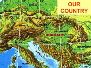
- 1. OUR COUNTRY
- 2. Factfile • Area: 93.036 km2 • Population: 10 000 000 heads • Capital city: Budapest • Major cities: Debrecen, Miskolc, Győr, Pécs Szeged, Kecskemét, Szombathely Nyíregyháza, Székesfehérvár • Main rivers: Danube and Tisza • Important lakes: Balaton, Fertő, Velencei and Tisza • Highest point: Kékes (1014 m) • National parks: 10
- 3. OUR REGION It is located in the northeastern part of Hungary. This region includes 3 counties: Hajdú-Bihar Szabolcs-Szatmár-Bereg Jász-Nagykun-Szolnok
- 4. What to know about this region? NORTH GREAT PLAIN REGION • huge agricultural area • good quality soil • ploughlands, grasslands, forests • River Tisza
- 5. • one of the warmest regions of the country • plenty of sunshine annual mean temperature: 10°C
- 6. Changes in annual mean temperature
- 7. Changes in the annual amount of precipitation, 1951-2004 (Source: OMSZ) not enough precipitation (400-500 mm) less or no snow during winter
- 8. Debrecen: the regional centre second largest Hungarian city nearly 200.000 people live here, but attracts more… busy industrial life food industry machine industry pharmaceutical industry
- 9. Educational and cultural centre University of Debrecen Csokonai Theatre Big Calvinist Church
- 10. Debrecen: centre of transportation M35 motorway Airport
- 11. climate change has a huge impact on agriculture many people live off the land in the Eastern part of Hungary droughts are present every year tourism can ˝win˝ on climate change warmer climate could attract more tourists to visit us weather extremes can destroy the crops they produce Major impacts of climate change on the region the ˝˝treasures˝ of the national park will be in danger in the future water supply problems
- 12. The climate of Hungary could change from continental to Mediterranean soon…
- 13. Hortobágy – ˝the Puszta˝ the first national park of Hungary (1973) cultural landscape with dry lands and fish ponds rich in birds <<< UNESCO World Heritage Site
- 14. Many interesting places to see… Csaroda, church Túristvándi, water mill Máriapócs, place of pilgrimage Abádszalók & Lake Tisza, perfect for recreation Hajdúszoboszló, spa Debrecen, flower parade rural traditions