16 April 2016 magnitude 7.8 earthquake strikes Ecuador

The 2016 Ecuador earthquake occurred on April 16 at 18:58:37 ECT with a moment magnitude of 7.8 and a maximum Mercalli intensity of VIII (Severe). The very large thrust earthquake was centered approximately 27 km (17 mi) from the towns of Muisne and Pedernales in a sparsely populated part of the country, and 170 km (110 mi) from the capital Quito, where it was felt strongly. Regions of Manta, Pedernales and Portoviejo accounted for over 75 percent of total casualties.[6] Manta's central commercial shopping district Tarqui, was completely destroyed. Widespread damage was caused across Manabi province, with structures hundreds of kilometres from the epicenter collapsing. At least 659 people were killed and 27,732 people injured. President Rafael Correa declared a state of emergency; 13,500 military personnel and police officers were dispatched for recovery operations.

Recomendados
Más contenido relacionado
Destacado
Destacado (20)
Similar a 16 April 2016 magnitude 7.8 earthquake strikes Ecuador
Similar a 16 April 2016 magnitude 7.8 earthquake strikes Ecuador (20)
Más de Professor Eric K. Noji, M.D., MPH, DTMH(Lon), FRCP(UK)hon
Más de Professor Eric K. Noji, M.D., MPH, DTMH(Lon), FRCP(UK)hon (20)
Último
Último (20)
16 April 2016 magnitude 7.8 earthquake strikes Ecuador
- 1. LEARNING FROM GLOBAL DISASTER LABORATORIES APRIL 16, 2016 EARTHQUAKE STRIKES ECUADOR
- 2. A M7.8, 20-KM-DEEP EARTHQUAKE LOCATED OFFSHORE ECUADOR STRUCK ON SATURDAY MIGHT, KILLING AT LEAST 77, WJTH MORE DEATHS EXPECTED
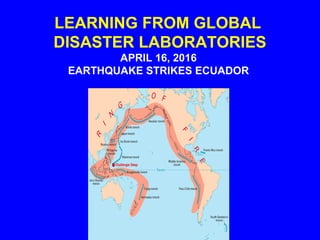
- 3. ECUADOR IN ON THE PACIFIC RING OF FIRE • CIRCUM- PACIFIC NATIONS ARE PRONE TO EARTHQUAKES AND TSUNAMIS
- 4. TECTONIC DEFORMATION EARTHQUAKE TSUNAMI GROUND SHAKING FAULT RUPTURE FOUNDATION FAILURE SITE AMPLIFICATION LIQUEFACTION LANDSLIDES AFTERSHOCKS SEICHE DAMAGE/LOSSDAMAGE/LOSS DAMAGE/ LOSSDAMAGE/ LOSS DAMAGE/ LOSSDAMAGE/ LOSS DAMAGE/ LOSSDAMAGE/ LOSS DAMAGE/ LOSSDAMAGE/ LOSS DAMAGE/ LOSSDAMAGE/ LOSS DAMAGE/ LOSSDAMAGE/ LOSS DAMAGE/ LOSSDAMAGE/ LOSS DAMAGE/ LOSSDAMAGE/ LOSS DAMAGE/LOSSDAMAGE/LOSS
- 5. INADEQUATE RESISTANCE TO HORIZONTAL GROUND SHAKING EARTHQUAKESEARTHQUAKES SOIL AMPLIFICATION PERMANENT DISPLACEMENT (SURFACE FAULTING & GROUND FAILURE) IRREGULARITIES IN ELEVATION AND PLAN FIRE FOLLOWING RUPTURE OF UTILITIES LACK OF DETAILING AND CONSTRUCTION MATERIALS INATTENTION TO NON- STRUCTURAL ELEMENTS CAUSES OF DAMAGE CAUSES OF DAMAGE GLOBAL “DISASTER LABORATORIES” GLOBAL “DISASTER LABORATORIES”
- 6. The two most devastated areas were Pedernales, a popular tourist destination with beaches lined with palm- trees and tropical thatch-hut restaurants, and nearby Cojimies.
- 7. "There are villages that are totally devastated," Pedernales' mayor, Gabriel Alcivar, said in a radio interview. "What happened here in Pedernales is catastrophic."
- 8. The 7.8 magnitude earthquake was felt hundreds of miles (km) away in the capital of Quito as well as in the large commercial city of Guayaquil, where rubble filled the streets and some buildings were cracked or partially collapsed.
- 9. - - - TO BE CONTINUED AS FACTUAL DETAILS BECOME AVAILABLE- - -
- 10. YOURYOUR COMMUNITYCOMMUNITY DATA BASESDATA BASES AND INFORMATIONAND INFORMATION HAZARDS: GROUND SHAKING GROUND FAILURE SURFACE FAULTING TECTONIC DEFORMATION TSUNAMI RUN UP AFTERSHOCKS •MONITORING •HAZARD MAPS •INVENTORY •VULNERABILITY •LOCATION RISK ACCEPTABLE RISK UNACCEPTABLE RISK BOOKS OFBOOKS OF KNOWLEDGEKNOWLEDGE •PREPAREDNESS •PROTECTION •EM RESPONSE •RECOSTRUCTION AND RECOVERY EARTHQUAKE DISASTEREARTHQUAKE DISASTER RESILIENCERESILIENCE
- 11. PILLARS OF EARTHQUAKE DISASTER RESILIENCE Preparedness Protection: Adoption and Implementation of a Modern Earthquake Engineering Building Code and Lifeline Standards Prevention: Land Use Planning and Base Isolation
- 12. PILLARS OF EARTHQUAKE DISASTER RESILIENCE (continued) Monitoring Realistic Earthquake Disaster Scenarios Timely Emergency Response (including search and Rescue and Emergency Medical Services) Cost-Effective Recovery and Reconstruction
- 13. THE CHALLENGE: CHANGING EXISTING POLICIES: CREATE, ADJUST, AND REALIGN PROGRAMS, PARTNERS AND PEOPLE UNTIL YOU HAVE CREATED THE KINDS OF TURNING POINTS NEEDED FOR MOVING TOWARDS EARTHQUAKE DISASTER RESILIENCE
- 14. AN UNDER-UTILIZED GLOBAL STRATEGY To Create Turning Points for Earthquake Disaster Resilience USING EDUCATIONAL SURGES CONTAINING THE PAST AND PRESENT LESSONS TO FOSTER AND ACCELERATE POLICY CHANGES
- 15. MOVING TOWARDS THE MUST- HAPPEN GLOBAL STRATEGY To Achieve Earthquake Disaster Resilience INTEGRATION OF SCIENTIFIC AND TECHNICAL SOLUTIONS WITH POLITICAL SOLUTIONS IN EVERY NATION FOR REALISTIC POLICIES ON PREPAREDNESS, PROTECTION, DISASTER SCENARIOS, EMERGENCY RESPONSE, RECONSTRUCTION, AND RECOVERY