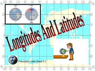
3. Longitudes and latitdues are
imaginary lines that we draw
around the globe to show us
exactly were a place is on the
earths surface.
When using these lines to find a
place we first write the latitude
and then the longitudes.
Francesco Vella Class 3.1
4. Latitude lines run east/west but they measure north or
south of the equator (0°) splitting the earth into the
Northern Hemisphere and Southern Hemisphere
Northern hemisphere
Southern Hemisphere
Francesco Vella Class 3.1
5. Lines of
latitude are
numbered
from 0° at
the equator
to 90° N.L.
at the North
Pole.
Lines of
latitude are
numbered
from 0° at
the equator
to 90° S.L. at
the South
Francesco Vella Class 3.1 Pole.
6. Tropic of Cancer 23.5˚ N
Equator 0˚
Tropic of Capricorn 23.5˚ S
Francesco Vella Class 3.1
7. North Pole
Lines of longitude are numbered east from the
Prime Meridian to the 180° line and west from
the Prime Meridian to the 180° line.
Francesco Vella Class 3.1
8. The Prime Meridian (0°) and the 180° line
split the earth into the Western
Hemisphere and Eastern Hemisphere.
Prime Meridian
Western Hemisphere
Eastern Hemisphere
Francesco Vella Class 3.1
9. The Maltese Islands are on latitudes 36˚N and on
longitudes 14˚E.
Places in Latitude Longitude
Malta
Sliema 35°55'N 14°30'E
Mosta 35°55'N 14°26'E
Gozo 36°03'N 14°15'E
Comino 36°01'N 14°20'E
Filfla 35°47'N 14°24'E
Valletta 35°54'N 14°31'E
Some of this information was taken from www.mapsofworld.com
10.
11. By using the equator and prime meridian, we can
divide the world into four hemispheres, north, south,
east, and west.
Francesco Vella Class 3.1
12.
13. -The Earth is divided into 24 time zones,
corresponding to 24 hours in a day.
-As the earth rotates, the sun shines in
different areas, moving from east to west
during the course of a day.
-Places that have the same Longitude will
be in the same time zone.
Francesco Vella Class 3.1