GIS Market Study of Internet Mapping Server (IMS) - Summary - Requirements and Comparison Matrix (2006)
•
1 recomendación•1,553 vistas

GIS Market Study of Internet Mapping Server (IMS) - Summary - Requirements and Comparison Matrix (2006) (Tags: arcims, arcsde, autodesk, comparison, esri, geomedia, intergraph, mapguide, mapinfo, mapserver, mapxtreme, matrix, potential, product, project, requirement, summary, survey, webgis, webmap)

Recomendados
Más contenido relacionado
Similar a GIS Market Study of Internet Mapping Server (IMS) - Summary - Requirements and Comparison Matrix (2006)
Similar a GIS Market Study of Internet Mapping Server (IMS) - Summary - Requirements and Comparison Matrix (2006) (20)
Más de Harsh Prakash (AWS, Azure, Security+, Agile, PMP, GISP)
Más de Harsh Prakash (AWS, Azure, Security+, Agile, PMP, GISP) (8)
Último
Último (20)
GIS Market Study of Internet Mapping Server (IMS) - Summary - Requirements and Comparison Matrix (2006)
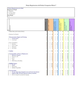
- 1. 1 2 4 8 2 4 1 2 1 2 1 2 2 1 0 0 0 0 5 5 4 4 0 0 3 3 5 15 3 9 3 9 2 6 2 6 4 • Vendor-based 3 5 15 3 9 1 3 2 6 2 6 5 • User-based 1 4 4 2 2 5 5 2 2 2 2 6 2 4 8 4 8 2 4 1 2 4 8 7 • Windows 3 4 12 4 12 2 6 1 3 4 12 8 • Linux/UNIX 2 3 6 0 0 2 4 1 2 3 6 9 • Macintosh 1 0 0 0 0 2 2 0 0 0 0 10 • Sun Solaris 1 3 3 0 0 2 2 0 0 3 3 11 3 4 12 3 9 4 12 4 12 3 9 12 3 3 9 2 6 5 15 5 15 3 9 13 • Webserver: Apache 3 3 9 0 0 5 15 5 15 0 0 14 • Webserver: IIS 2 4 8 4 8 5 10 5 10 4 8 15 • JAVA 2 4 8 4 8 5 10 5 10 4 8 16 • .NET 2 4 8 4 8 3 6 3 6 4 8 17 • PHP/Python/Perl/Ruby 2 1 2 0 0 5 10 4 8 0 0 18 3 4 12 3 9 3 9 3 9 3 9 19 • Oracle 3 5 15 5 15 3 9 3 9 5 15 20 • SQL Server 2 5 10 5 10 3 6 3 6 5 10 21 • MySQL/PostgreSQL 2 1 2 1 2 3 6 3 6 1 2 22 3 3 9 4 12 4 12 4 12 3 9 23 • Accepts wide-range of popular vector and raster data formats 3 3 9 4 12 3 9 4 12 3 9 24 • Supports XML and other important industry standards 3 3 9 3 9 4 12 4 12 3 9 25 • Does not depend on proprietary language 2 0 0 4 8 5 10 4 8 0 0 * Project Requirements are in Bold Requirement Weight 0 - 5 3 = Required 2 = Good to Have 1 = Not Required Point Range Market Share and Evolution History Purchase Cost Benefit Documentation, Support and Training Ease of Installation Project Requirements with Product Comparison Matrix * RequirementWeight ESRIArcIMS+ArcSDE IntergraphGeoMedia WebMapProfessional MapServerOpensource+ FastCGI,Libraries AutodeskMapGuide Opensource MapInfoMapXtreme+ SpatialWare Stability SN Requirement Customizability and Ease of Deployment RDBMS Support Interoperability
- 2. 26 3 5 15 5 15 5 15 5 15 5 15 27 • Can provide basic mapping without plug-in 3 5 15 5 15 5 15 5 15 5 15 28 • Can display point on map from coordinate table or log 3 5 15 5 15 5 15 5 15 5 15 29 • Supports automatic rendering of standard map elements 3 5 15 5 15 5 15 5 15 5 15 30 • Allows panning 3 5 15 5 15 5 15 5 15 5 15 31 • Allows fixed and interactive zooming 3 5 15 5 15 5 15 5 15 5 15 32 • Allows SQL style querying and selection 3 5 15 5 15 5 15 5 15 5 15 33 • Allows identification of selected map feature 3 5 15 5 15 5 15 5 15 5 15 34 • Allows buffering of selected map feature 2 4 8 4 8 4 8 5 10 4 8 35 • Allows measuring of linear distance 2 5 10 5 10 5 10 5 10 5 10 36 2 4 8 4 8 3 6 3 6 2 4 37 • Can support web-based administration 2 0 0 0 0 5 10 5 10 0 0 38 • Includes feature-rich website authoring/designing tool 2 4 8 4 8 3 6 4 8 3 6 39 • Includes map usage tool 2 0 0 0 0 0 0 5 10 0 0 40 • Includes map password protection tool 1 0 0 5 5 0 0 5 5 0 0 41 • Includes gazetteer/metadata functionality 2 0 0 0 0 0 0 0 0 0 0 42 • Includes Geocode/Reverse Geocode functionality 2 0 0 5 10 0 0 0 0 0 0 43 • Includes Red-Lining functionality 2 0 0 5 10 0 0 0 0 0 0 44 • Includes Driving Direction/Optimal Route/Linear Analysis functionality 1 0 0 2 2 0 0 0 0 0 0 45 • Supports creation of summary report/task list from browser 3 0 0 0 0 0 0 5 15 2 6 46 • Supports smart tiling of data 2 0 0 5 10 5 10 5 10 0 0 47 • Supports feature streaming 2 5 10 5 10 0 0 2 4 0 0 48 • Supports advanced cartography 2 5 10 3 6 2 4 2 4 2 4 49 • Supports label conflict-resolution 2 5 10 3 6 2 4 2 4 2 4 50 • Supports 3D view 1 0 0 0 0 0 0 0 0 0 0 51 • Supports dynamic Macromedia Flash output 2 5 10 0 0 5 10 0 0 5 10 52 • Supports WMS/WFS 2 5 10 5 10 5 10 5 10 5 10 53 • Supports SOAP/REST 2 5 10 5 10 5 10 2 4 5 10 54 • Allows changing map’s linear unit 1 5 5 5 5 5 5 5 5 5 5 55 • Allows changing map’s coordinate system/projection 1 0 0 0 0 5 5 5 5 0 0 56 • Allows users to extract/plot data from website 1 0 0 0 0 0 0 5 5 0 0 57 3 4 12 4 12 4 12 4 12 4 12 58 • Internet Explorer Browser 3 5 15 5 15 5 15 5 15 5 15 59 • Netscape Navigator Browser 2 5 10 5 10 5 10 5 10 5 10 60 • Firefox Browser 2 1 2 1 2 5 10 4 8 1 2 61 • Safari Browser 2 1 2 1 2 5 10 4 8 1 2 62 3 4 12 3 9 2 6 2 6 3 9 63 3 5 15 3 9 3 9 3 9 2 6 64 • Can leverages multi-processor architecture 3 5 15 5 15 0 0 1 3 5 15 65 • Fast in distributing vector data 2 4 8 4 8 2 4 2 4 2 4 66 • Fast in distributing raster data 2 2 4 2 4 4 8 2 4 2 4 67 2 5 10 1 2 3 6 2 4 1 2 SN 212 203 217 217 173505 Requirement Weight ESRIArcIMS +ArcSDE Intergraph GeoMedia WebMap Professional MapServer Opensource+ FastCGI, Libraries Autodesk MapGuide Opensource 501 Advanced Functionality Ease of Use Security Performance, Scalability and Speed (query versioning etc) Legacy Advantage, Learning Curve 149 Requirement 486517 MapInfo MapXtreme 428 Basic Functionality 517 486 501 505 428 0 100 200 300 400 500 600 MapInfo MapXtreme Autodesk MapGuide Opensource MapServer Opensource + FastCGI, Libraries Intergraph GeoMedia WebMap Professional ESRI ArcIMS + ArcSDE