SlideShare una empresa de Scribd logo
1 de 23
Descargar para leer sin conexión
Near-Real-Time Ocean Surface Vector Wind
    Retrievals from Passive Microwave
 Measurements: Status and Future Plans

  Mike Bettenhausen1 Ian Adams1                  Peter Gaiser1
                   Bill Johnston2
                1 Remote Sensing Division

               Naval Research Laboratory
               2 Computational   Physics, Inc.


                   IGARSS, 2011
Basis for Passive Ocean Wind Retrievals
                                                                                      10.7 GHz at 8 m/s Wind Speed
                                                                          0.6
  Tb = TU + τ [eTS + (1 − e)TD ]                                                                   V-pol
                                                                          0.4                      H-pol
  approximates measured Tb


                                        Directional Dependence (Kelvin)
                                                                                                   3rd
                                                                                                   4th

  where:                                                                  0.2
   Tb = brightness temp.
   TS = sea surface temp.                                                   0

     e = ocean surface emissivity                                         -0.2
     τ = atmospheric transmissivity
   TU = atmospheric upwelling temp.                                       -0.4

   TD = atmospheric downwelling temp.
                                                                                 0      90         180          270      360
                                                                                     Relative Wind Direction (degrees)

      Ocean surface emission and scattering vary with wind
      vector
           Wind stress drives ocean surface wave spectrum
           Emission is also enhanced by sea foam
      Wind direction retrieval requires polarimetric radiometer
           Need 3rd/4th Stokes components to reduce direction
           ambiguity
Passive Ocean Vector Wind Timeline

      Early 1990’s: identification of wind direction signal in SSM/I
      data
      Mid-1990’s and later: aircraft campaigns to measure the
      wind direction signal for polarimetric radiometers
      1990’s and later: rough surface modeling of wind direction
      signal in ocean surface emissivity and reflectivity
      2003: WindSat launched
      2004 and later: WindSat ocean vector wind retrievals
      demonstrated
      2006: operational assimilation of WindSat wind vector
      retrievals in Navy NOGAPS model begins
      2006: NPOESS CMIS canceled; replaced with MIS
      2010: NPOESS split into JPSS and DWSS; DWSS
      microwave configuration TBD
WindSat Description

      Fully polarimetric at 10.7, 18.7 and 37 GHz
      Swath limited to allow for forward and aft looks
      Three rows of feed horns so for forward look
            18.7 GHz scan leads 37 GHz scan
            10.7 GHz scan lags 37 GHz scan
      http://www.nrl.navy.mil/windsat
    Freq.       Channels             BW     EIA     IFOV
   (GHz)                           (MHz)   (deg)     (km)
     6.8            v, h             125    54.0   39 x 71
    10.7    v, h, +/- 45, lc, rc     300    50.3   25 x 38
    18.7    v, h, +/- 45, lc, rc     750    55.9   16 x 27
    23.8            v, h             500    53.5   20 x 30
    37.0    v, h, +/- 45, lc, rc    2000    53.5    8 x 13
WindSat Reflector and Feeds
ission Overview


d
ometry


OESS

tellite


t                       Feedbench view from the main reflector.
Interpolation and Footprint Matching


      All frequencies and
      polarizations are interpolated
      to a common field of view
      Reduces side lobe
      contributions
      Mitigates shadowing effects
      seen in 3rd and 4th Stokes
      near coastlines and cloud or
      precipitation boundaries
      Varies with scan angle and       WindSat field-of-views for a subset of
      position in the orbit            4 spins.
Sensor Data Records (SDRs)

     Swath width is about 900 km
         6.8 GHz available over about 3/4 of the swath
     Three chosen resolutions (not optimized):
         Low: 50 km x 71 km (All channels)
         Medium: 35 km x 53 km (No 6.8 GHz channels)
         High: 25 km x 35 km (No 6.8 GHz channels)
     Sampling is the same for all resolutions
         about 12.5 km along track and along scan
     Retrieval distance to land depends on orientation of
     elliptical footprint to coastline
         Low: 80 km to 115 km
         Medium: 55 km to 80 km
         High: 35 km to 60 km
Quality Control Flagging

      Two rain flags
       1. Retrieved cloud liquid water path > 0.2 mm
       2. First flag expanded by one “pixel”
      Radio-Frequency Interference (RFI) (more on this later)
      Land contamination
          Footprints at each resolution are convolved with high
          resolution land mask
          Orientation of elliptical footprint is accounted for
      Sea ice
      Satellite attitude anomalies
          IFM is inaccurate if attitude changes significantly over
          several spins
          10.7 GHz matching to 18.7 GHz channels is worst case
Retrieval Algorithm
      Uses our parameterized geophysical model function
      Retrieval of 5 EDRs: SST , W , PWV , CLW and wind direction φR
      Inversion technique is two-stage optimal estimation (OE)

      SST and PWV        W (wind speed)
                                                CLW              Low Res.
         NWP or              Linear
                                               Constant          Initial Est.
      Climatologies       Regression


                                First Stage OE
                                Retrieval for W,
                                PWV and CLW
        Initial Estimates                                     Ф
                                                      Chi-squared Est.
     Low Res.  Med. Res.
                                                      1 to 4 Ambiguities
      Med. Res.  Hi. Res.


                              Second Stage OE                 Ф
                              Retrieval for SST,         Final Wind
                              W, PWV and CLW         Direction Retrievals
Ambiguity Selection

      Circular vector median filter based on Shaffer, et al, TGRS, vol.
      29, 1991
      13 x 13 box size

      Cost function weighting          3
                                                        First Rank Skill
                                                        No. of Ambiguities
           by wind speed             2.5
           by first rank χ2
                                       2
           probability
      Nudging: Initialize using      1.5
      spatially interpolated wind
                                       1
      from NWP
                                     0.5
           Ambiguities reported
           both with and without       0
           nudging                         0   5    10 15 20 25              30
                                                   Wind Speed (m/s)
Radio Frequency Interference

      Persistent terrestrial and space-based RFI sources at 6.8,
      10.7 and 18.7 GHz
          Space-based RFI: signals from satellites broadcasting from
          geosynchronous orbit reflect off earth surface
      Detection of RFI over ocean uses chi-squared test from
      wind retrieval algorithm
          Adams, et al, “Identification of ocean-reflected
          radio-frequency interference using WindSat retrieval
          chi-square probability,” IEEE GRSL, vol. 7, pp. 406-410,
          2010.
      RFI has changed throughout WindSat Mission
          Adams, et al, “Ocean-Reflected Radio-Frequency
          Interference During the WindSat Era,” poster from
          MicroRad 2010.
RFI Mitigation
      Frequency bands
      flagged using:
          Lon. / Lat. mask
          Line-of-sight
          calculation from
          satellite to WindSat
          Pixel-by-pixel
          flagging varies
          along scan
      Northern Hemi. for
      descending pass
      Southern Hemi. for
      ascending pass
      Channels flagged for
      RFI are excluded from
      retrieval
          Pixel-by-pixel
Statistical Evaluations of WindSat OSVW Retrievals

        Compare to nearest QuikSCAT wind retrieval within 25 km
        and within one hour of the WindSat measurement
        Seven-month data set: 2008-09 through 2009-03
        Exclude rain (cloud liquid water (CLW) retrieval > 0.2 mm),
        land, sea ice contamination and RFI


   The QuikSCAT L2B OVW 25 km data were obtained from the Physical
   Oceanography Distributed Active Archive Center (PO.DAAC) at the NASA Jet
   Proplulsion Laboratory, Pasadena, CA. http://podaac.jpl.nasa.gov.
Wind Speed Comparisons

                                                      Good agreement below 20 m/s
                                                      Above 20 m/s collocation errors become more important
                                                             Fewer collocations
                                                             Higher temporal and spatial variability
                                             4                                                                                                       4


                                                                                                     WindSat - QuikSCAT Wind Speed Std. Dev. (m/s)
  WindSat - QuikSCAT Wind Speed Bias (m/s)


                                                           Binned by QuikSCAT Wind Speed                                                                         Binned by QuikSCAT Wind Speed
                                             3                                                                                                                   Binned by WindSat Wind Speed
                                                           Binned by WindSat Wind Speed
                                                                                                                                                     3

                                             2


                                              1                                                                                                      2


                                             0
                                                                                                                                                     1
                                             -1


                                             -2                                                                                                      0
                                                  0    5       10     15       20          25   30                                                       0   5       10     15       20          25   30
                                                                Wind Speed (m/s)                                                                                      Wind Speed (m/s)
Wind Direction Comparisons
     Performance
         improves with increasing wind speed
         is comparable to QuikSCAT above about 6 or 7 m/s
         weak dependence on ambiguity selection above 10 m/s
         wind speed
                                                       60
             WindSat - QuikSCAT Wind Dir. RMS (deg.)


                                                                    Selected Ambiguity (Nudged)
                                                       50           Selected Ambiguity (No Nudging)


                                                       40


                                                       30


                                                       20


                                                       10


                                                        0
                                                            5   10       15       20          25      30
                                                                 QuikSCAT Wind Speed (m/s)
Graphics Display of WindSat Winds


       Winds are displayed as colored barbs
       Retrieved columnar cloud liquid water is plotted in
       gray-scale in the background
             Helps to interpret winds because current algorithm is
             sensitive to rain
             Provides additional information on the structure of storms
             and fronts
       All examples shown here use Hi. Res. WindSat retrievals.


  Thanks to Tom Lee (NRL-Monterey) for choosing several of the examples
  shown in this talk.
Hurricane Earl
Eastern Pacific Cold Front - PWV
Eastern Pacific Cold Front - Winds
Pacific Northwest Front
Cyclone South of Aluetian Islands
Canada and Alaska Gap Winds
Future Plans

      Examples show rain effects are the primary limitation of
      current algorithm
      Work to improve retrievals in rain
          Basic physics investigations
          Parameterizations for use in the forward model
          Modified retrieval algorithm when rain is present
      Calibration
          Reanalysis of pre-launch sensor test data
          Documentation of sensor test data and analysis
          High wind speeds and high water vapor
      Faraday rotation
          Three-shell algorithm for accurate near-real-time
          corrections
          Singh and Bettenhausen, Radio Science, in press

Más contenido relacionado

La actualidad más candente

Basic radar principles 2012
Basic radar principles 2012Basic radar principles 2012
Basic radar principles 2012Jaime Gonzalez
 
Radar Systems for NTU, 1 Nov 2014
Radar Systems for NTU, 1 Nov 2014Radar Systems for NTU, 1 Nov 2014
Radar Systems for NTU, 1 Nov 2014TBSS Group
 
synthetic aperture radar
synthetic aperture radarsynthetic aperture radar
synthetic aperture radarAmit Rastogi
 
Structur Alanalysis
Structur AlanalysisStructur Alanalysis
Structur AlanalysisShah Naseer
 
Principles of RADAR Systems
Principles of RADAR SystemsPrinciples of RADAR Systems
Principles of RADAR Systemsjanakiravi
 
Seismic Data Interpretation
Seismic Data InterpretationSeismic Data Interpretation
Seismic Data InterpretationAli Osman Öncel
 
Some basic concepts
Some basic conceptsSome basic concepts
Some basic conceptsJamal Ahmad
 
GeoStreamer PESA News 042009 Andrew Long
GeoStreamer PESA News 042009 Andrew LongGeoStreamer PESA News 042009 Andrew Long
GeoStreamer PESA News 042009 Andrew LongAndrew Long
 
ppt on radar system
 ppt on radar system ppt on radar system
ppt on radar systemBiswajit Das
 
igarss_2011_presentation_brcic.ppt
igarss_2011_presentation_brcic.pptigarss_2011_presentation_brcic.ppt
igarss_2011_presentation_brcic.pptgrssieee
 
Airbone Radar Applications by Wg Cdr Anupam Tiwari
Airbone Radar Applications by Wg Cdr Anupam TiwariAirbone Radar Applications by Wg Cdr Anupam Tiwari
Airbone Radar Applications by Wg Cdr Anupam Tiwarianupamtiwari1972
 
A New Underwater Acoustic Navigation Method Based on the Doppler Principle
A New Underwater Acoustic Navigation Method Based on the Doppler PrincipleA New Underwater Acoustic Navigation Method Based on the Doppler Principle
A New Underwater Acoustic Navigation Method Based on the Doppler PrincipleNooria Sukmaningtyas
 
Radar 2009 a 14 airborne pulse doppler radar
Radar 2009 a 14 airborne pulse doppler radarRadar 2009 a 14 airborne pulse doppler radar
Radar 2009 a 14 airborne pulse doppler radarForward2025
 
Radar 2009 a 4 radar equation
Radar 2009 a  4 radar equationRadar 2009 a  4 radar equation
Radar 2009 a 4 radar equationForward2025
 
Synthetic aperture radar
Synthetic aperture radarSynthetic aperture radar
Synthetic aperture radarMahesh pawar
 
4-IGARSS_2011_v4.ppt
4-IGARSS_2011_v4.ppt4-IGARSS_2011_v4.ppt
4-IGARSS_2011_v4.pptgrssieee
 

La actualidad más candente (20)

Basic radar principles 2012
Basic radar principles 2012Basic radar principles 2012
Basic radar principles 2012
 
Radar Systems for NTU, 1 Nov 2014
Radar Systems for NTU, 1 Nov 2014Radar Systems for NTU, 1 Nov 2014
Radar Systems for NTU, 1 Nov 2014
 
synthetic aperture radar
synthetic aperture radarsynthetic aperture radar
synthetic aperture radar
 
Structur Alanalysis
Structur AlanalysisStructur Alanalysis
Structur Alanalysis
 
Principles of RADAR Systems
Principles of RADAR SystemsPrinciples of RADAR Systems
Principles of RADAR Systems
 
radar-ppt
radar-pptradar-ppt
radar-ppt
 
Seismic Data Interpretation
Seismic Data InterpretationSeismic Data Interpretation
Seismic Data Interpretation
 
Some basic concepts
Some basic conceptsSome basic concepts
Some basic concepts
 
GeoStreamer PESA News 042009 Andrew Long
GeoStreamer PESA News 042009 Andrew LongGeoStreamer PESA News 042009 Andrew Long
GeoStreamer PESA News 042009 Andrew Long
 
ppt on radar system
 ppt on radar system ppt on radar system
ppt on radar system
 
igarss_2011_presentation_brcic.ppt
igarss_2011_presentation_brcic.pptigarss_2011_presentation_brcic.ppt
igarss_2011_presentation_brcic.ppt
 
Airbone Radar Applications by Wg Cdr Anupam Tiwari
Airbone Radar Applications by Wg Cdr Anupam TiwariAirbone Radar Applications by Wg Cdr Anupam Tiwari
Airbone Radar Applications by Wg Cdr Anupam Tiwari
 
A New Underwater Acoustic Navigation Method Based on the Doppler Principle
A New Underwater Acoustic Navigation Method Based on the Doppler PrincipleA New Underwater Acoustic Navigation Method Based on the Doppler Principle
A New Underwater Acoustic Navigation Method Based on the Doppler Principle
 
Radar 2009 a 14 airborne pulse doppler radar
Radar 2009 a 14 airborne pulse doppler radarRadar 2009 a 14 airborne pulse doppler radar
Radar 2009 a 14 airborne pulse doppler radar
 
Radar 2009 a 4 radar equation
Radar 2009 a  4 radar equationRadar 2009 a  4 radar equation
Radar 2009 a 4 radar equation
 
Synthetic aperture radar
Synthetic aperture radarSynthetic aperture radar
Synthetic aperture radar
 
PresentationSAR
PresentationSARPresentationSAR
PresentationSAR
 
4-IGARSS_2011_v4.ppt
4-IGARSS_2011_v4.ppt4-IGARSS_2011_v4.ppt
4-IGARSS_2011_v4.ppt
 
Pulse Doppler Radar
Pulse Doppler RadarPulse Doppler Radar
Pulse Doppler Radar
 
Extended abstract
Extended abstractExtended abstract
Extended abstract
 

Destacado

IGARSS2011_aster_volcano_urai.ppt
IGARSS2011_aster_volcano_urai.pptIGARSS2011_aster_volcano_urai.ppt
IGARSS2011_aster_volcano_urai.pptgrssieee
 
Alexandra Karamitrou.ppt
Alexandra Karamitrou.pptAlexandra Karamitrou.ppt
Alexandra Karamitrou.pptgrssieee
 
SPATIAL VARIATIONS OF L-BAND EMISSIVITY IN ANTARCTICA, FIRST RESULTS FROM THE...
SPATIAL VARIATIONS OF L-BAND EMISSIVITY IN ANTARCTICA, FIRST RESULTS FROM THE...SPATIAL VARIATIONS OF L-BAND EMISSIVITY IN ANTARCTICA, FIRST RESULTS FROM THE...
SPATIAL VARIATIONS OF L-BAND EMISSIVITY IN ANTARCTICA, FIRST RESULTS FROM THE...grssieee
 
1148_DAILY_ESTIMATES_OF_THE_TROPOSPHERIC_AEROSOL_OPTICAL_THICKNESS_OVER_LAND_...
1148_DAILY_ESTIMATES_OF_THE_TROPOSPHERIC_AEROSOL_OPTICAL_THICKNESS_OVER_LAND_...1148_DAILY_ESTIMATES_OF_THE_TROPOSPHERIC_AEROSOL_OPTICAL_THICKNESS_OVER_LAND_...
1148_DAILY_ESTIMATES_OF_THE_TROPOSPHERIC_AEROSOL_OPTICAL_THICKNESS_OVER_LAND_...grssieee
 
igarss11swot-vadon-callahan-psc-s3.110725.pptx
igarss11swot-vadon-callahan-psc-s3.110725.pptxigarss11swot-vadon-callahan-psc-s3.110725.pptx
igarss11swot-vadon-callahan-psc-s3.110725.pptxgrssieee
 
IGARSS2011_Gustavsson_v3.ppt
IGARSS2011_Gustavsson_v3.pptIGARSS2011_Gustavsson_v3.ppt
IGARSS2011_Gustavsson_v3.pptgrssieee
 
VERIFICATION_&_VALIDATION_OF_A_SEMANTIC_IMAGE_TAGGING_FRAMEWORK_VIA_GENERATIO...
VERIFICATION_&_VALIDATION_OF_A_SEMANTIC_IMAGE_TAGGING_FRAMEWORK_VIA_GENERATIO...VERIFICATION_&_VALIDATION_OF_A_SEMANTIC_IMAGE_TAGGING_FRAMEWORK_VIA_GENERATIO...
VERIFICATION_&_VALIDATION_OF_A_SEMANTIC_IMAGE_TAGGING_FRAMEWORK_VIA_GENERATIO...grssieee
 
IGARSS2011_05072011_HO.ppt
IGARSS2011_05072011_HO.pptIGARSS2011_05072011_HO.ppt
IGARSS2011_05072011_HO.pptgrssieee
 

Destacado (8)

IGARSS2011_aster_volcano_urai.ppt
IGARSS2011_aster_volcano_urai.pptIGARSS2011_aster_volcano_urai.ppt
IGARSS2011_aster_volcano_urai.ppt
 
Alexandra Karamitrou.ppt
Alexandra Karamitrou.pptAlexandra Karamitrou.ppt
Alexandra Karamitrou.ppt
 
SPATIAL VARIATIONS OF L-BAND EMISSIVITY IN ANTARCTICA, FIRST RESULTS FROM THE...
SPATIAL VARIATIONS OF L-BAND EMISSIVITY IN ANTARCTICA, FIRST RESULTS FROM THE...SPATIAL VARIATIONS OF L-BAND EMISSIVITY IN ANTARCTICA, FIRST RESULTS FROM THE...
SPATIAL VARIATIONS OF L-BAND EMISSIVITY IN ANTARCTICA, FIRST RESULTS FROM THE...
 
1148_DAILY_ESTIMATES_OF_THE_TROPOSPHERIC_AEROSOL_OPTICAL_THICKNESS_OVER_LAND_...
1148_DAILY_ESTIMATES_OF_THE_TROPOSPHERIC_AEROSOL_OPTICAL_THICKNESS_OVER_LAND_...1148_DAILY_ESTIMATES_OF_THE_TROPOSPHERIC_AEROSOL_OPTICAL_THICKNESS_OVER_LAND_...
1148_DAILY_ESTIMATES_OF_THE_TROPOSPHERIC_AEROSOL_OPTICAL_THICKNESS_OVER_LAND_...
 
igarss11swot-vadon-callahan-psc-s3.110725.pptx
igarss11swot-vadon-callahan-psc-s3.110725.pptxigarss11swot-vadon-callahan-psc-s3.110725.pptx
igarss11swot-vadon-callahan-psc-s3.110725.pptx
 
IGARSS2011_Gustavsson_v3.ppt
IGARSS2011_Gustavsson_v3.pptIGARSS2011_Gustavsson_v3.ppt
IGARSS2011_Gustavsson_v3.ppt
 
VERIFICATION_&_VALIDATION_OF_A_SEMANTIC_IMAGE_TAGGING_FRAMEWORK_VIA_GENERATIO...
VERIFICATION_&_VALIDATION_OF_A_SEMANTIC_IMAGE_TAGGING_FRAMEWORK_VIA_GENERATIO...VERIFICATION_&_VALIDATION_OF_A_SEMANTIC_IMAGE_TAGGING_FRAMEWORK_VIA_GENERATIO...
VERIFICATION_&_VALIDATION_OF_A_SEMANTIC_IMAGE_TAGGING_FRAMEWORK_VIA_GENERATIO...
 
IGARSS2011_05072011_HO.ppt
IGARSS2011_05072011_HO.pptIGARSS2011_05072011_HO.ppt
IGARSS2011_05072011_HO.ppt
 

Similar a bettenhausen_igarss11_talk.pdf

Fukao Plenary.ppt
Fukao Plenary.pptFukao Plenary.ppt
Fukao Plenary.pptgrssieee
 
Fukao Plenary4.pdf
Fukao Plenary4.pdfFukao Plenary4.pdf
Fukao Plenary4.pdfnickohrn
 
Acoustic and seismic effects of the 2013 Chelyabinsk meteorite as measured by...
Acoustic and seismic effects of the 2013 Chelyabinsk meteorite as measured by...Acoustic and seismic effects of the 2013 Chelyabinsk meteorite as measured by...
Acoustic and seismic effects of the 2013 Chelyabinsk meteorite as measured by...Ivan Kitov
 
igarss_2011_cfosat.ppt
igarss_2011_cfosat.pptigarss_2011_cfosat.ppt
igarss_2011_cfosat.pptgrssieee
 
Validation_SWOT_ground_airborne_Fjortoft.ppt
Validation_SWOT_ground_airborne_Fjortoft.pptValidation_SWOT_ground_airborne_Fjortoft.ppt
Validation_SWOT_ground_airborne_Fjortoft.pptgrssieee
 
Towards the identification of the primary particle nature by the radiodetecti...
Towards the identification of the primary particle nature by the radiodetecti...Towards the identification of the primary particle nature by the radiodetecti...
Towards the identification of the primary particle nature by the radiodetecti...Ahmed Ammar Rebai PhD
 
SIXTEEN CHANNEL, NON-SCANNING AIRBORNE LIDAR SURFACE TOPOGRAPHY (LIST) SIMULATOR
SIXTEEN CHANNEL, NON-SCANNING AIRBORNE LIDAR SURFACE TOPOGRAPHY (LIST) SIMULATORSIXTEEN CHANNEL, NON-SCANNING AIRBORNE LIDAR SURFACE TOPOGRAPHY (LIST) SIMULATOR
SIXTEEN CHANNEL, NON-SCANNING AIRBORNE LIDAR SURFACE TOPOGRAPHY (LIST) SIMULATORgrssieee
 
TU2.T10.2.ppt
TU2.T10.2.pptTU2.T10.2.ppt
TU2.T10.2.pptgrssieee
 
TU1.T10.2.pptx
TU1.T10.2.pptxTU1.T10.2.pptx
TU1.T10.2.pptxgrssieee
 
3_Xorbits_InSAR_IGARSS2011.ppt
3_Xorbits_InSAR_IGARSS2011.ppt3_Xorbits_InSAR_IGARSS2011.ppt
3_Xorbits_InSAR_IGARSS2011.pptgrssieee
 
TU3.T10.5.ppt
TU3.T10.5.pptTU3.T10.5.ppt
TU3.T10.5.pptgrssieee
 
Seismic Method Estimate velocity from seismic data.pptx
Seismic Method Estimate velocity from seismic  data.pptxSeismic Method Estimate velocity from seismic  data.pptx
Seismic Method Estimate velocity from seismic data.pptxAlMamun560346
 
NRAO2020RadioChicago
NRAO2020RadioChicagoNRAO2020RadioChicago
NRAO2020RadioChicagoJr-Wei Tsai
 
Radar 2009 a 10 radar clutter.2pdf
Radar 2009 a 10 radar clutter.2pdfRadar 2009 a 10 radar clutter.2pdf
Radar 2009 a 10 radar clutter.2pdfForward2025
 
Mw presentation 1
Mw presentation 1Mw presentation 1
Mw presentation 1Amizareza
 

Similar a bettenhausen_igarss11_talk.pdf (20)

Fukao Plenary.ppt
Fukao Plenary.pptFukao Plenary.ppt
Fukao Plenary.ppt
 
Fukao Plenary4.pdf
Fukao Plenary4.pdfFukao Plenary4.pdf
Fukao Plenary4.pdf
 
MEA
MEAMEA
MEA
 
Rocca.ppt
Rocca.pptRocca.ppt
Rocca.ppt
 
Acoustic and seismic effects of the 2013 Chelyabinsk meteorite as measured by...
Acoustic and seismic effects of the 2013 Chelyabinsk meteorite as measured by...Acoustic and seismic effects of the 2013 Chelyabinsk meteorite as measured by...
Acoustic and seismic effects of the 2013 Chelyabinsk meteorite as measured by...
 
igarss_2011_cfosat.ppt
igarss_2011_cfosat.pptigarss_2011_cfosat.ppt
igarss_2011_cfosat.ppt
 
DLA_Presentation
DLA_PresentationDLA_Presentation
DLA_Presentation
 
Validation_SWOT_ground_airborne_Fjortoft.ppt
Validation_SWOT_ground_airborne_Fjortoft.pptValidation_SWOT_ground_airborne_Fjortoft.ppt
Validation_SWOT_ground_airborne_Fjortoft.ppt
 
Towards the identification of the primary particle nature by the radiodetecti...
Towards the identification of the primary particle nature by the radiodetecti...Towards the identification of the primary particle nature by the radiodetecti...
Towards the identification of the primary particle nature by the radiodetecti...
 
Towards the identification of the primary particle nature by the radiodetecti...
Towards the identification of the primary particle nature by the radiodetecti...Towards the identification of the primary particle nature by the radiodetecti...
Towards the identification of the primary particle nature by the radiodetecti...
 
Gps measurements
Gps measurementsGps measurements
Gps measurements
 
SIXTEEN CHANNEL, NON-SCANNING AIRBORNE LIDAR SURFACE TOPOGRAPHY (LIST) SIMULATOR
SIXTEEN CHANNEL, NON-SCANNING AIRBORNE LIDAR SURFACE TOPOGRAPHY (LIST) SIMULATORSIXTEEN CHANNEL, NON-SCANNING AIRBORNE LIDAR SURFACE TOPOGRAPHY (LIST) SIMULATOR
SIXTEEN CHANNEL, NON-SCANNING AIRBORNE LIDAR SURFACE TOPOGRAPHY (LIST) SIMULATOR
 
TU2.T10.2.ppt
TU2.T10.2.pptTU2.T10.2.ppt
TU2.T10.2.ppt
 
TU1.T10.2.pptx
TU1.T10.2.pptxTU1.T10.2.pptx
TU1.T10.2.pptx
 
3_Xorbits_InSAR_IGARSS2011.ppt
3_Xorbits_InSAR_IGARSS2011.ppt3_Xorbits_InSAR_IGARSS2011.ppt
3_Xorbits_InSAR_IGARSS2011.ppt
 
TU3.T10.5.ppt
TU3.T10.5.pptTU3.T10.5.ppt
TU3.T10.5.ppt
 
Seismic Method Estimate velocity from seismic data.pptx
Seismic Method Estimate velocity from seismic  data.pptxSeismic Method Estimate velocity from seismic  data.pptx
Seismic Method Estimate velocity from seismic data.pptx
 
NRAO2020RadioChicago
NRAO2020RadioChicagoNRAO2020RadioChicago
NRAO2020RadioChicago
 
Radar 2009 a 10 radar clutter.2pdf
Radar 2009 a 10 radar clutter.2pdfRadar 2009 a 10 radar clutter.2pdf
Radar 2009 a 10 radar clutter.2pdf
 
Mw presentation 1
Mw presentation 1Mw presentation 1
Mw presentation 1
 

Más de grssieee

Tangent height accuracy of Superconducting Submillimeter-Wave Limb-Emission S...
Tangent height accuracy of Superconducting Submillimeter-Wave Limb-Emission S...Tangent height accuracy of Superconducting Submillimeter-Wave Limb-Emission S...
Tangent height accuracy of Superconducting Submillimeter-Wave Limb-Emission S...grssieee
 
SEGMENTATION OF POLARIMETRIC SAR DATA WITH A MULTI-TEXTURE PRODUCT MODEL
SEGMENTATION OF POLARIMETRIC SAR DATA WITH A MULTI-TEXTURE PRODUCT MODELSEGMENTATION OF POLARIMETRIC SAR DATA WITH A MULTI-TEXTURE PRODUCT MODEL
SEGMENTATION OF POLARIMETRIC SAR DATA WITH A MULTI-TEXTURE PRODUCT MODELgrssieee
 
TWO-POINT STATISTIC OF POLARIMETRIC SAR DATA TWO-POINT STATISTIC OF POLARIMET...
TWO-POINT STATISTIC OF POLARIMETRIC SAR DATA TWO-POINT STATISTIC OF POLARIMET...TWO-POINT STATISTIC OF POLARIMETRIC SAR DATA TWO-POINT STATISTIC OF POLARIMET...
TWO-POINT STATISTIC OF POLARIMETRIC SAR DATA TWO-POINT STATISTIC OF POLARIMET...grssieee
 
THE SENTINEL-1 MISSION AND ITS APPLICATION CAPABILITIES
THE SENTINEL-1 MISSION AND ITS APPLICATION CAPABILITIESTHE SENTINEL-1 MISSION AND ITS APPLICATION CAPABILITIES
THE SENTINEL-1 MISSION AND ITS APPLICATION CAPABILITIESgrssieee
 
GMES SPACE COMPONENT:PROGRAMMATIC STATUS
GMES SPACE COMPONENT:PROGRAMMATIC STATUSGMES SPACE COMPONENT:PROGRAMMATIC STATUS
GMES SPACE COMPONENT:PROGRAMMATIC STATUSgrssieee
 
PROGRESSES OF DEVELOPMENT OF CFOSAT SCATTEROMETER
PROGRESSES OF DEVELOPMENT OF CFOSAT SCATTEROMETERPROGRESSES OF DEVELOPMENT OF CFOSAT SCATTEROMETER
PROGRESSES OF DEVELOPMENT OF CFOSAT SCATTEROMETERgrssieee
 
DEVELOPMENT OF ALGORITHMS AND PRODUCTS FOR SUPPORTING THE ITALIAN HYPERSPECTR...
DEVELOPMENT OF ALGORITHMS AND PRODUCTS FOR SUPPORTING THE ITALIAN HYPERSPECTR...DEVELOPMENT OF ALGORITHMS AND PRODUCTS FOR SUPPORTING THE ITALIAN HYPERSPECTR...
DEVELOPMENT OF ALGORITHMS AND PRODUCTS FOR SUPPORTING THE ITALIAN HYPERSPECTR...grssieee
 
EO-1/HYPERION: NEARING TWELVE YEARS OF SUCCESSFUL MISSION SCIENCE OPERATION A...
EO-1/HYPERION: NEARING TWELVE YEARS OF SUCCESSFUL MISSION SCIENCE OPERATION A...EO-1/HYPERION: NEARING TWELVE YEARS OF SUCCESSFUL MISSION SCIENCE OPERATION A...
EO-1/HYPERION: NEARING TWELVE YEARS OF SUCCESSFUL MISSION SCIENCE OPERATION A...grssieee
 
test 34mb wo animations
test  34mb wo animationstest  34mb wo animations
test 34mb wo animationsgrssieee
 
2011_Fox_Tax_Worksheets.pdf
2011_Fox_Tax_Worksheets.pdf2011_Fox_Tax_Worksheets.pdf
2011_Fox_Tax_Worksheets.pdfgrssieee
 
DLR open house
DLR open houseDLR open house
DLR open housegrssieee
 
DLR open house
DLR open houseDLR open house
DLR open housegrssieee
 
DLR open house
DLR open houseDLR open house
DLR open housegrssieee
 
Tana_IGARSS2011.ppt
Tana_IGARSS2011.pptTana_IGARSS2011.ppt
Tana_IGARSS2011.pptgrssieee
 
Solaro_IGARSS_2011.ppt
Solaro_IGARSS_2011.pptSolaro_IGARSS_2011.ppt
Solaro_IGARSS_2011.pptgrssieee
 

Más de grssieee (20)

Tangent height accuracy of Superconducting Submillimeter-Wave Limb-Emission S...
Tangent height accuracy of Superconducting Submillimeter-Wave Limb-Emission S...Tangent height accuracy of Superconducting Submillimeter-Wave Limb-Emission S...
Tangent height accuracy of Superconducting Submillimeter-Wave Limb-Emission S...
 
SEGMENTATION OF POLARIMETRIC SAR DATA WITH A MULTI-TEXTURE PRODUCT MODEL
SEGMENTATION OF POLARIMETRIC SAR DATA WITH A MULTI-TEXTURE PRODUCT MODELSEGMENTATION OF POLARIMETRIC SAR DATA WITH A MULTI-TEXTURE PRODUCT MODEL
SEGMENTATION OF POLARIMETRIC SAR DATA WITH A MULTI-TEXTURE PRODUCT MODEL
 
TWO-POINT STATISTIC OF POLARIMETRIC SAR DATA TWO-POINT STATISTIC OF POLARIMET...
TWO-POINT STATISTIC OF POLARIMETRIC SAR DATA TWO-POINT STATISTIC OF POLARIMET...TWO-POINT STATISTIC OF POLARIMETRIC SAR DATA TWO-POINT STATISTIC OF POLARIMET...
TWO-POINT STATISTIC OF POLARIMETRIC SAR DATA TWO-POINT STATISTIC OF POLARIMET...
 
THE SENTINEL-1 MISSION AND ITS APPLICATION CAPABILITIES
THE SENTINEL-1 MISSION AND ITS APPLICATION CAPABILITIESTHE SENTINEL-1 MISSION AND ITS APPLICATION CAPABILITIES
THE SENTINEL-1 MISSION AND ITS APPLICATION CAPABILITIES
 
GMES SPACE COMPONENT:PROGRAMMATIC STATUS
GMES SPACE COMPONENT:PROGRAMMATIC STATUSGMES SPACE COMPONENT:PROGRAMMATIC STATUS
GMES SPACE COMPONENT:PROGRAMMATIC STATUS
 
PROGRESSES OF DEVELOPMENT OF CFOSAT SCATTEROMETER
PROGRESSES OF DEVELOPMENT OF CFOSAT SCATTEROMETERPROGRESSES OF DEVELOPMENT OF CFOSAT SCATTEROMETER
PROGRESSES OF DEVELOPMENT OF CFOSAT SCATTEROMETER
 
DEVELOPMENT OF ALGORITHMS AND PRODUCTS FOR SUPPORTING THE ITALIAN HYPERSPECTR...
DEVELOPMENT OF ALGORITHMS AND PRODUCTS FOR SUPPORTING THE ITALIAN HYPERSPECTR...DEVELOPMENT OF ALGORITHMS AND PRODUCTS FOR SUPPORTING THE ITALIAN HYPERSPECTR...
DEVELOPMENT OF ALGORITHMS AND PRODUCTS FOR SUPPORTING THE ITALIAN HYPERSPECTR...
 
EO-1/HYPERION: NEARING TWELVE YEARS OF SUCCESSFUL MISSION SCIENCE OPERATION A...
EO-1/HYPERION: NEARING TWELVE YEARS OF SUCCESSFUL MISSION SCIENCE OPERATION A...EO-1/HYPERION: NEARING TWELVE YEARS OF SUCCESSFUL MISSION SCIENCE OPERATION A...
EO-1/HYPERION: NEARING TWELVE YEARS OF SUCCESSFUL MISSION SCIENCE OPERATION A...
 
EO-1/HYPERION: NEARING TWELVE YEARS OF SUCCESSFUL MISSION SCIENCE OPERATION A...
EO-1/HYPERION: NEARING TWELVE YEARS OF SUCCESSFUL MISSION SCIENCE OPERATION A...EO-1/HYPERION: NEARING TWELVE YEARS OF SUCCESSFUL MISSION SCIENCE OPERATION A...
EO-1/HYPERION: NEARING TWELVE YEARS OF SUCCESSFUL MISSION SCIENCE OPERATION A...
 
Test
TestTest
Test
 
test 34mb wo animations
test  34mb wo animationstest  34mb wo animations
test 34mb wo animations
 
Test 70MB
Test 70MBTest 70MB
Test 70MB
 
Test 70MB
Test 70MBTest 70MB
Test 70MB
 
2011_Fox_Tax_Worksheets.pdf
2011_Fox_Tax_Worksheets.pdf2011_Fox_Tax_Worksheets.pdf
2011_Fox_Tax_Worksheets.pdf
 
DLR open house
DLR open houseDLR open house
DLR open house
 
DLR open house
DLR open houseDLR open house
DLR open house
 
DLR open house
DLR open houseDLR open house
DLR open house
 
Tana_IGARSS2011.ppt
Tana_IGARSS2011.pptTana_IGARSS2011.ppt
Tana_IGARSS2011.ppt
 
Solaro_IGARSS_2011.ppt
Solaro_IGARSS_2011.pptSolaro_IGARSS_2011.ppt
Solaro_IGARSS_2011.ppt
 

Último

Uneak White's Personal Brand Exploration Presentation
Uneak White's Personal Brand Exploration PresentationUneak White's Personal Brand Exploration Presentation
Uneak White's Personal Brand Exploration Presentationuneakwhite
 
TVB_The Vietnam Believer Newsletter_May 6th, 2024_ENVol. 006.pdf
TVB_The Vietnam Believer Newsletter_May 6th, 2024_ENVol. 006.pdfTVB_The Vietnam Believer Newsletter_May 6th, 2024_ENVol. 006.pdf
TVB_The Vietnam Believer Newsletter_May 6th, 2024_ENVol. 006.pdfbelieveminhh
 
The Abortion pills for sale in Qatar@Doha [+27737758557] []Deira Dubai Kuwait
The Abortion pills for sale in Qatar@Doha [+27737758557] []Deira Dubai KuwaitThe Abortion pills for sale in Qatar@Doha [+27737758557] []Deira Dubai Kuwait
The Abortion pills for sale in Qatar@Doha [+27737758557] []Deira Dubai Kuwaitdaisycvs
 
Cracking the 'Career Pathing' Slideshare
Cracking the 'Career Pathing' SlideshareCracking the 'Career Pathing' Slideshare
Cracking the 'Career Pathing' SlideshareWorkforce Group
 
Unveiling Falcon Invoice Discounting: Leading the Way as India's Premier Bill...
Unveiling Falcon Invoice Discounting: Leading the Way as India's Premier Bill...Unveiling Falcon Invoice Discounting: Leading the Way as India's Premier Bill...
Unveiling Falcon Invoice Discounting: Leading the Way as India's Premier Bill...Falcon Invoice Discounting
 
Falcon Invoice Discounting: Unlock Your Business Potential
Falcon Invoice Discounting: Unlock Your Business PotentialFalcon Invoice Discounting: Unlock Your Business Potential
Falcon Invoice Discounting: Unlock Your Business PotentialFalcon investment
 
Organizational Transformation Lead with Culture
Organizational Transformation Lead with CultureOrganizational Transformation Lead with Culture
Organizational Transformation Lead with CultureSeta Wicaksana
 
Cannabis Legalization World Map: 2024 Updated
Cannabis Legalization World Map: 2024 UpdatedCannabis Legalization World Map: 2024 Updated
Cannabis Legalization World Map: 2024 UpdatedCannaBusinessPlans
 
Power point presentation on enterprise performance management
Power point presentation on enterprise performance managementPower point presentation on enterprise performance management
Power point presentation on enterprise performance managementVaishnaviGunji
 
Rice Manufacturers in India | Shree Krishna Exports
Rice Manufacturers in India | Shree Krishna ExportsRice Manufacturers in India | Shree Krishna Exports
Rice Manufacturers in India | Shree Krishna ExportsShree Krishna Exports
 
Paradip CALL GIRL❤7091819311❤CALL GIRLS IN ESCORT SERVICE WE ARE PROVIDING
Paradip CALL GIRL❤7091819311❤CALL GIRLS IN ESCORT SERVICE WE ARE PROVIDINGParadip CALL GIRL❤7091819311❤CALL GIRLS IN ESCORT SERVICE WE ARE PROVIDING
Paradip CALL GIRL❤7091819311❤CALL GIRLS IN ESCORT SERVICE WE ARE PROVIDINGpr788182
 
Call 7737669865 Vadodara Call Girls Service at your Door Step Available All Time
Call 7737669865 Vadodara Call Girls Service at your Door Step Available All TimeCall 7737669865 Vadodara Call Girls Service at your Door Step Available All Time
Call 7737669865 Vadodara Call Girls Service at your Door Step Available All Timegargpaaro
 
joint cost.pptx COST ACCOUNTING Sixteenth Edition ...
joint cost.pptx  COST ACCOUNTING  Sixteenth Edition                          ...joint cost.pptx  COST ACCOUNTING  Sixteenth Edition                          ...
joint cost.pptx COST ACCOUNTING Sixteenth Edition ...NadhimTaha
 
Mckinsey foundation level Handbook for Viewing
Mckinsey foundation level Handbook for ViewingMckinsey foundation level Handbook for Viewing
Mckinsey foundation level Handbook for ViewingNauman Safdar
 
Katrina Personal Brand Project and portfolio 1
Katrina Personal Brand Project and portfolio 1Katrina Personal Brand Project and portfolio 1
Katrina Personal Brand Project and portfolio 1kcpayne
 
SEO Case Study: How I Increased SEO Traffic & Ranking by 50-60% in 6 Months
SEO Case Study: How I Increased SEO Traffic & Ranking by 50-60%  in 6 MonthsSEO Case Study: How I Increased SEO Traffic & Ranking by 50-60%  in 6 Months
SEO Case Study: How I Increased SEO Traffic & Ranking by 50-60% in 6 MonthsIndeedSEO
 
Getting Real with AI - Columbus DAW - May 2024 - Nick Woo from AlignAI
Getting Real with AI - Columbus DAW - May 2024 - Nick Woo from AlignAIGetting Real with AI - Columbus DAW - May 2024 - Nick Woo from AlignAI
Getting Real with AI - Columbus DAW - May 2024 - Nick Woo from AlignAITim Wilson
 

Último (20)

Uneak White's Personal Brand Exploration Presentation
Uneak White's Personal Brand Exploration PresentationUneak White's Personal Brand Exploration Presentation
Uneak White's Personal Brand Exploration Presentation
 
TVB_The Vietnam Believer Newsletter_May 6th, 2024_ENVol. 006.pdf
TVB_The Vietnam Believer Newsletter_May 6th, 2024_ENVol. 006.pdfTVB_The Vietnam Believer Newsletter_May 6th, 2024_ENVol. 006.pdf
TVB_The Vietnam Believer Newsletter_May 6th, 2024_ENVol. 006.pdf
 
The Abortion pills for sale in Qatar@Doha [+27737758557] []Deira Dubai Kuwait
The Abortion pills for sale in Qatar@Doha [+27737758557] []Deira Dubai KuwaitThe Abortion pills for sale in Qatar@Doha [+27737758557] []Deira Dubai Kuwait
The Abortion pills for sale in Qatar@Doha [+27737758557] []Deira Dubai Kuwait
 
Cracking the 'Career Pathing' Slideshare
Cracking the 'Career Pathing' SlideshareCracking the 'Career Pathing' Slideshare
Cracking the 'Career Pathing' Slideshare
 
Unveiling Falcon Invoice Discounting: Leading the Way as India's Premier Bill...
Unveiling Falcon Invoice Discounting: Leading the Way as India's Premier Bill...Unveiling Falcon Invoice Discounting: Leading the Way as India's Premier Bill...
Unveiling Falcon Invoice Discounting: Leading the Way as India's Premier Bill...
 
Falcon Invoice Discounting: Unlock Your Business Potential
Falcon Invoice Discounting: Unlock Your Business PotentialFalcon Invoice Discounting: Unlock Your Business Potential
Falcon Invoice Discounting: Unlock Your Business Potential
 
Organizational Transformation Lead with Culture
Organizational Transformation Lead with CultureOrganizational Transformation Lead with Culture
Organizational Transformation Lead with Culture
 
Cannabis Legalization World Map: 2024 Updated
Cannabis Legalization World Map: 2024 UpdatedCannabis Legalization World Map: 2024 Updated
Cannabis Legalization World Map: 2024 Updated
 
Power point presentation on enterprise performance management
Power point presentation on enterprise performance managementPower point presentation on enterprise performance management
Power point presentation on enterprise performance management
 
Rice Manufacturers in India | Shree Krishna Exports
Rice Manufacturers in India | Shree Krishna ExportsRice Manufacturers in India | Shree Krishna Exports
Rice Manufacturers in India | Shree Krishna Exports
 
Paradip CALL GIRL❤7091819311❤CALL GIRLS IN ESCORT SERVICE WE ARE PROVIDING
Paradip CALL GIRL❤7091819311❤CALL GIRLS IN ESCORT SERVICE WE ARE PROVIDINGParadip CALL GIRL❤7091819311❤CALL GIRLS IN ESCORT SERVICE WE ARE PROVIDING
Paradip CALL GIRL❤7091819311❤CALL GIRLS IN ESCORT SERVICE WE ARE PROVIDING
 
!~+971581248768>> SAFE AND ORIGINAL ABORTION PILLS FOR SALE IN DUBAI AND ABUD...
!~+971581248768>> SAFE AND ORIGINAL ABORTION PILLS FOR SALE IN DUBAI AND ABUD...!~+971581248768>> SAFE AND ORIGINAL ABORTION PILLS FOR SALE IN DUBAI AND ABUD...
!~+971581248768>> SAFE AND ORIGINAL ABORTION PILLS FOR SALE IN DUBAI AND ABUD...
 
Call 7737669865 Vadodara Call Girls Service at your Door Step Available All Time
Call 7737669865 Vadodara Call Girls Service at your Door Step Available All TimeCall 7737669865 Vadodara Call Girls Service at your Door Step Available All Time
Call 7737669865 Vadodara Call Girls Service at your Door Step Available All Time
 
joint cost.pptx COST ACCOUNTING Sixteenth Edition ...
joint cost.pptx  COST ACCOUNTING  Sixteenth Edition                          ...joint cost.pptx  COST ACCOUNTING  Sixteenth Edition                          ...
joint cost.pptx COST ACCOUNTING Sixteenth Edition ...
 
unwanted pregnancy Kit [+918133066128] Abortion Pills IN Dubai UAE Abudhabi
unwanted pregnancy Kit [+918133066128] Abortion Pills IN Dubai UAE Abudhabiunwanted pregnancy Kit [+918133066128] Abortion Pills IN Dubai UAE Abudhabi
unwanted pregnancy Kit [+918133066128] Abortion Pills IN Dubai UAE Abudhabi
 
Mifty kit IN Salmiya (+918133066128) Abortion pills IN Salmiyah Cytotec pills
Mifty kit IN Salmiya (+918133066128) Abortion pills IN Salmiyah Cytotec pillsMifty kit IN Salmiya (+918133066128) Abortion pills IN Salmiyah Cytotec pills
Mifty kit IN Salmiya (+918133066128) Abortion pills IN Salmiyah Cytotec pills
 
Mckinsey foundation level Handbook for Viewing
Mckinsey foundation level Handbook for ViewingMckinsey foundation level Handbook for Viewing
Mckinsey foundation level Handbook for Viewing
 
Katrina Personal Brand Project and portfolio 1
Katrina Personal Brand Project and portfolio 1Katrina Personal Brand Project and portfolio 1
Katrina Personal Brand Project and portfolio 1
 
SEO Case Study: How I Increased SEO Traffic & Ranking by 50-60% in 6 Months
SEO Case Study: How I Increased SEO Traffic & Ranking by 50-60%  in 6 MonthsSEO Case Study: How I Increased SEO Traffic & Ranking by 50-60%  in 6 Months
SEO Case Study: How I Increased SEO Traffic & Ranking by 50-60% in 6 Months
 
Getting Real with AI - Columbus DAW - May 2024 - Nick Woo from AlignAI
Getting Real with AI - Columbus DAW - May 2024 - Nick Woo from AlignAIGetting Real with AI - Columbus DAW - May 2024 - Nick Woo from AlignAI
Getting Real with AI - Columbus DAW - May 2024 - Nick Woo from AlignAI
 

bettenhausen_igarss11_talk.pdf

  • 1. Near-Real-Time Ocean Surface Vector Wind Retrievals from Passive Microwave Measurements: Status and Future Plans Mike Bettenhausen1 Ian Adams1 Peter Gaiser1 Bill Johnston2 1 Remote Sensing Division Naval Research Laboratory 2 Computational Physics, Inc. IGARSS, 2011
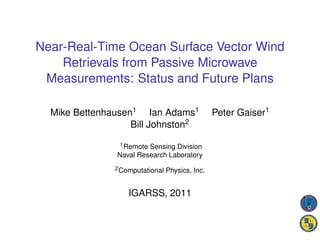
  • 2. Basis for Passive Ocean Wind Retrievals 10.7 GHz at 8 m/s Wind Speed 0.6 Tb = TU + τ [eTS + (1 − e)TD ] V-pol 0.4 H-pol approximates measured Tb Directional Dependence (Kelvin) 3rd 4th where: 0.2 Tb = brightness temp. TS = sea surface temp. 0 e = ocean surface emissivity -0.2 τ = atmospheric transmissivity TU = atmospheric upwelling temp. -0.4 TD = atmospheric downwelling temp. 0 90 180 270 360 Relative Wind Direction (degrees) Ocean surface emission and scattering vary with wind vector Wind stress drives ocean surface wave spectrum Emission is also enhanced by sea foam Wind direction retrieval requires polarimetric radiometer Need 3rd/4th Stokes components to reduce direction ambiguity
  • 3. Passive Ocean Vector Wind Timeline Early 1990’s: identification of wind direction signal in SSM/I data Mid-1990’s and later: aircraft campaigns to measure the wind direction signal for polarimetric radiometers 1990’s and later: rough surface modeling of wind direction signal in ocean surface emissivity and reflectivity 2003: WindSat launched 2004 and later: WindSat ocean vector wind retrievals demonstrated 2006: operational assimilation of WindSat wind vector retrievals in Navy NOGAPS model begins 2006: NPOESS CMIS canceled; replaced with MIS 2010: NPOESS split into JPSS and DWSS; DWSS microwave configuration TBD
  • 4. WindSat Description Fully polarimetric at 10.7, 18.7 and 37 GHz Swath limited to allow for forward and aft looks Three rows of feed horns so for forward look 18.7 GHz scan leads 37 GHz scan 10.7 GHz scan lags 37 GHz scan http://www.nrl.navy.mil/windsat Freq. Channels BW EIA IFOV (GHz) (MHz) (deg) (km) 6.8 v, h 125 54.0 39 x 71 10.7 v, h, +/- 45, lc, rc 300 50.3 25 x 38 18.7 v, h, +/- 45, lc, rc 750 55.9 16 x 27 23.8 v, h 500 53.5 20 x 30 37.0 v, h, +/- 45, lc, rc 2000 53.5 8 x 13
  • 5. WindSat Reflector and Feeds ission Overview d ometry OESS tellite t Feedbench view from the main reflector.
  • 6. Interpolation and Footprint Matching All frequencies and polarizations are interpolated to a common field of view Reduces side lobe contributions Mitigates shadowing effects seen in 3rd and 4th Stokes near coastlines and cloud or precipitation boundaries Varies with scan angle and WindSat field-of-views for a subset of position in the orbit 4 spins.
  • 7. Sensor Data Records (SDRs) Swath width is about 900 km 6.8 GHz available over about 3/4 of the swath Three chosen resolutions (not optimized): Low: 50 km x 71 km (All channels) Medium: 35 km x 53 km (No 6.8 GHz channels) High: 25 km x 35 km (No 6.8 GHz channels) Sampling is the same for all resolutions about 12.5 km along track and along scan Retrieval distance to land depends on orientation of elliptical footprint to coastline Low: 80 km to 115 km Medium: 55 km to 80 km High: 35 km to 60 km
  • 8. Quality Control Flagging Two rain flags 1. Retrieved cloud liquid water path > 0.2 mm 2. First flag expanded by one “pixel” Radio-Frequency Interference (RFI) (more on this later) Land contamination Footprints at each resolution are convolved with high resolution land mask Orientation of elliptical footprint is accounted for Sea ice Satellite attitude anomalies IFM is inaccurate if attitude changes significantly over several spins 10.7 GHz matching to 18.7 GHz channels is worst case
  • 9. Retrieval Algorithm Uses our parameterized geophysical model function Retrieval of 5 EDRs: SST , W , PWV , CLW and wind direction φR Inversion technique is two-stage optimal estimation (OE) SST and PWV W (wind speed) CLW Low Res. NWP or Linear Constant Initial Est. Climatologies Regression First Stage OE Retrieval for W, PWV and CLW Initial Estimates Ф Chi-squared Est. Low Res.  Med. Res. 1 to 4 Ambiguities Med. Res.  Hi. Res. Second Stage OE Ф Retrieval for SST, Final Wind W, PWV and CLW Direction Retrievals
  • 10. Ambiguity Selection Circular vector median filter based on Shaffer, et al, TGRS, vol. 29, 1991 13 x 13 box size Cost function weighting 3 First Rank Skill No. of Ambiguities by wind speed 2.5 by first rank χ2 2 probability Nudging: Initialize using 1.5 spatially interpolated wind 1 from NWP 0.5 Ambiguities reported both with and without 0 nudging 0 5 10 15 20 25 30 Wind Speed (m/s)
  • 11. Radio Frequency Interference Persistent terrestrial and space-based RFI sources at 6.8, 10.7 and 18.7 GHz Space-based RFI: signals from satellites broadcasting from geosynchronous orbit reflect off earth surface Detection of RFI over ocean uses chi-squared test from wind retrieval algorithm Adams, et al, “Identification of ocean-reflected radio-frequency interference using WindSat retrieval chi-square probability,” IEEE GRSL, vol. 7, pp. 406-410, 2010. RFI has changed throughout WindSat Mission Adams, et al, “Ocean-Reflected Radio-Frequency Interference During the WindSat Era,” poster from MicroRad 2010.
  • 12. RFI Mitigation Frequency bands flagged using: Lon. / Lat. mask Line-of-sight calculation from satellite to WindSat Pixel-by-pixel flagging varies along scan Northern Hemi. for descending pass Southern Hemi. for ascending pass Channels flagged for RFI are excluded from retrieval Pixel-by-pixel
  • 13. Statistical Evaluations of WindSat OSVW Retrievals Compare to nearest QuikSCAT wind retrieval within 25 km and within one hour of the WindSat measurement Seven-month data set: 2008-09 through 2009-03 Exclude rain (cloud liquid water (CLW) retrieval > 0.2 mm), land, sea ice contamination and RFI The QuikSCAT L2B OVW 25 km data were obtained from the Physical Oceanography Distributed Active Archive Center (PO.DAAC) at the NASA Jet Proplulsion Laboratory, Pasadena, CA. http://podaac.jpl.nasa.gov.
  • 14. Wind Speed Comparisons Good agreement below 20 m/s Above 20 m/s collocation errors become more important Fewer collocations Higher temporal and spatial variability 4 4 WindSat - QuikSCAT Wind Speed Std. Dev. (m/s) WindSat - QuikSCAT Wind Speed Bias (m/s) Binned by QuikSCAT Wind Speed Binned by QuikSCAT Wind Speed 3 Binned by WindSat Wind Speed Binned by WindSat Wind Speed 3 2 1 2 0 1 -1 -2 0 0 5 10 15 20 25 30 0 5 10 15 20 25 30 Wind Speed (m/s) Wind Speed (m/s)
  • 15. Wind Direction Comparisons Performance improves with increasing wind speed is comparable to QuikSCAT above about 6 or 7 m/s weak dependence on ambiguity selection above 10 m/s wind speed 60 WindSat - QuikSCAT Wind Dir. RMS (deg.) Selected Ambiguity (Nudged) 50 Selected Ambiguity (No Nudging) 40 30 20 10 0 5 10 15 20 25 30 QuikSCAT Wind Speed (m/s)
  • 16. Graphics Display of WindSat Winds Winds are displayed as colored barbs Retrieved columnar cloud liquid water is plotted in gray-scale in the background Helps to interpret winds because current algorithm is sensitive to rain Provides additional information on the structure of storms and fronts All examples shown here use Hi. Res. WindSat retrievals. Thanks to Tom Lee (NRL-Monterey) for choosing several of the examples shown in this talk.
  • 18. Eastern Pacific Cold Front - PWV
  • 19. Eastern Pacific Cold Front - Winds
  • 21. Cyclone South of Aluetian Islands
  • 22. Canada and Alaska Gap Winds
  • 23. Future Plans Examples show rain effects are the primary limitation of current algorithm Work to improve retrievals in rain Basic physics investigations Parameterizations for use in the forward model Modified retrieval algorithm when rain is present Calibration Reanalysis of pre-launch sensor test data Documentation of sensor test data and analysis High wind speeds and high water vapor Faraday rotation Three-shell algorithm for accurate near-real-time corrections Singh and Bettenhausen, Radio Science, in press