Final ppt gr
•Descargar como PPTX, PDF•
2 recomendaciones•1,190 vistas


Recomendados
Más contenido relacionado
La actualidad más candente
La actualidad más candente (20)
Destacado
Destacado (9)
Similar a Final ppt gr
Similar a Final ppt gr (20)
Más de Hamzah Meraj, Faculty of Architecture, Jamia Millia Islamia, New delhi
Más de Hamzah Meraj, Faculty of Architecture, Jamia Millia Islamia, New delhi (20)
Último
Último (20)
Final ppt gr
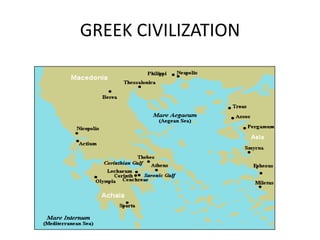
- 2. Greek civilization Climatic conditions The climate is moderate, neither too cold nor too hot which favored outdoor life The hot sun and sudden unexpected showers of rain led to construction of portico , colonnades Geological condition Greece and its islands had plenty of building materials. Unrivalled marble was plenty near Athens. Greeks made use of this marble to produce finest sculpture Geographical conditions The country is mountainous and separated by hills. The area is surrounded on all 3 sides by sea with innumerable islands. The coast-line is indented with many natural harbors. They mainly depended for their expansion of kingdom on colonization Political condition They were the first to develop democracy. Law were made by people to protect there interest.
- 3. Religious condition The religion of ‘Aegean’ was based on nature worship They had many deities in the form of human, sacred bulls RHEA mother goddess was supreme The worship was carried on sacrificial alter, in open courtyards or shrines The Greek gods were conceived in human form with human emotions The Greek deities were Zeus, Hera, Apollo, Athena, Ares, Artemis, Aphr odite, Hermes, Hephaestus, Demeter, Dionysus , Poseidon.` Historical conditions Aegean civilisation started in 3000 B.C. Social economic condition Trade and commerce, science and astronomy were developed. Shipping Silver mining and silversmiths
- 4. Greeks encouraged literature, music, and drama, art, architecture and town planning. Hence they constructed stadiums, polestar, theatres, basilica and agora They constructed buildings suited to their out door life like administrative buildings, theatres , agora etc The Greek temples were usually oriented towards east so the statues of deities were lit by morning sun. Trade included Ivory and gems from Egypt Elephants from India Silk from China Wool from countries surrounding Greece Purple dye from the eastern countries Grain from areas around the Black Sea
- 5. Town planning City was called as ‘polis’- community of families related by common ancestors ideal polis 5000 people Most of this size except few like Athens with 20,000 people City grew around acropolis surrounding farm with agora or market place, consisting of public buildings Sports and recreation in gymnasium Drama and festival in open theatre Milesian religious site of great Apollo sanctuary was located 14 miles to the south of the city. Early Greek towns had an irregular street pattern, resulting from its organic growth Later Hellenistic towns such as Priene had a formal rectilinear pattern The town was made up of only residential houses.
- 7. Milestos Scientific town planning Designed by Hippodamus. Introduced grid pattern of road system. The site was leveled peninsula jutting into the sea at the mouth of river Hippocampus planned the grid iron pattern of road system to the general direction of the peninsula rather than orienting it to the cardinal points of the compass HOUSES Greek sought privacy Designed for comfort and on climatic condition Rooms opened to central courtyard Simple and equal to all without class discrimination Paving of streets , water reservoirs, underground drainage Sewage disposal and water supply system not present. He divided the city into 3 district zones To the north was the residential area, the agora at the centre and another was a place for major temples. southern area as also residential. Paving of streets , water reservoirs, and underground drainage were provided for houses. Sewage disposal and water supply distribution were not provided. Town had walls surrounding them.
- 8. PRIENE PLAN OF PRIENE Orthogonal grid was used with regular blocks of houses measuring 120 * 160 feet 6 streets ran east- west 15 minor streets were stepped n-s At center was rectangular agora Over north of agora was temple of Athena and theatre At south was stadium
- 9. OLYNTHUS Olynthus is located on a peninsula that extends into the north Aegean Sea. It lies on two flat-topped hills, next to the Sandanus River, which empties into the sea 2.5 km (about 1.5 miles) to the south. The Greeks often chose to locate a city near a seaport for trade reasons, but inland far enough to provide security from invasion. The surrounding land is gently rolling, but marshland extends to the south, and the large hills rise to the north. The region is well-wooded in the hills, and has plenty of pasture land and fertile soil for growing crops
- 10. Lay out in a grid form of rectangular blocks, most containing two rows of five houses. Between the two rows is a narrow cobbled alley, which was probably for drainage. As ancient authors recommend, the houses have maximum exposure to the south to take advantage of light and warmth from the sun. Long avenues follow the grid's main northsouth axis. Most streets and avenues are, on average, 5 meters (17 feet) wide. Other road is wider at 19 meters, and seems to have been a main thoroughfare The public center, or agora, of the town is believed to be in the open space toward the southwest on the North Hill. Only three public buildings were found here, in the northeast corner of the space: a stoa*, a bouleterion, and a fountain house. At the fountain house people came with vessels to carry water to their homes. The fountain was supplied by an underground terracotta pipe that has been traced running north across town, and is believed to tap a fresh mountain source 12 km away
- 11. . Shops tend to be concentrated in the west part of North Hill. More surprising is the apparent lack of temples or shrines, which are so closely connected with town life elsewhere. Temples were often built on the most prominent spot in or around a town; at Olynthus, the highest ground on North Hill is where the agora sits, but no sanctuaries were found here Difference between natural cities and Hippodameian cities The main difference between organized cities and those which developed through a natural process over a long period of time are the parallel streets and the use of a grid in planning. The grid developed into a rectangular system and was the result of purely functional reasons. The grid presents the simplest solution of layout and with the fewest complications. Conclusion By studying the layout of the cities which were developed through a natural process and those which were planned according to the Hippodameian system we find that they had one feature in common: the form of the ancient town was generally simple. In both of the above mentioned categories one could easily move from any part of the city to its center, first because one could see it from everywhere- distances being such as to permit this- and because one could move directly towards it either by taking one natural turn in the cities formed through natural growth or by a right angle turn in the Hippodameian cities
- 12. ROMAN EMPIRE
- 13. Roman civilization Climate condition Climate of the area was varying. In the north was temperate climate, in the south was tropical and central region was cordial. Geographic condition Rome was founded near river Tiber and was surrounded by seven mountains. Geological condition Stone, timber, iron and copper was used by used by them .terra-cotta and bricks were manufactured. Religious condition They had many gods, but had no strong religious feeling. Temples were built. Each house had altar for family god. Ancestor worship also existed. Political condition They had organised government with laws. Colonial cities followed the shape of military camps.
- 14. Historical condition There was a unified government with strong army. Cites in Rome developed after 753 B.C. Far cities became part of Roman empire for self rule by all the people. Socio economic condition Romans were empire builders. They were great warriors, hard working and patriotic. Difference in social status of people. Decorated villas hint at the luxurious lifestyle enjoyed by wealthy Pompeian's. The large house has one side slightly elevated where a theater, complete with a stage and three entrances, was constructed. A domestic chapel attests to private worship of the Egyptian divinity Isis. Marble was widely used in the construction of Pompeii.
- 15. POMPEII At the heart of the city was the forum lined with public buildings. MAP OF POMPII Pompeii had streets forming irregular rectangles. Forum in Pompeii was rectangular in shape and dominated by a temple of Jupiter at one end of the access of the forum
- 17. •Pompeii is an example of an roman town not made up of perfect right angles and straight lines . •While Pompeii's plan includes straight roads it lacks the nice right angles at street levels. The footprint of the city does not follow proper geometry unlike other town of Rome ,and Pompeii's overall footprint is roughly trapezoidal in shape. Great archaeologist Haverfield , attributes two possible causatives of this shape •The previously existing italic-tribal element of the town and the other • possible influence from the military that is ideal of trying to occupy a specific piece of land despite its asymmetry. •However Pompeii does not truly resembles cestrum planning but it’s a best fit fusion of the rectangular ,cestrum plan with previous construction of overlaying physical geometryr blocks of flats were built. Cestrum was basically the heart of roman military fully capable of supporting the entire army , including people and animals along with all their food and supply. This led to derivation of cardo and decamanus.ideally cardo and decamanus are two major axes Cardus E-W Decumanus N-S which should split the city into four equal quarters through straight lines running at right angles to each other.Where the two converged was the forum .The rest of the space was divided into squares in
- 18. Pompeian's used marble to decorate floors, walls and fountains. Pompeii had many fountains. The beautiful decorations and ornamentations are evidence of the Romans’ esthetic talent. Fountains and wells outside the houses were built so that even horses would be able to drink from them. The water in the city’s channels changed automatically, so that it would always be fresh. The city is filled with splendid portraits that are found in private homes, in shops and in public areas. Archaeologists agree that not all treasures of Pompeii have been fully discovered. Substantial areas of the site still remain to be excavated.
- 19. Public baths Another proof of luxurious living is the public baths. They were generally made up of a suite of dressing rooms and bathing chambers with hot, or caldaria; warm, or tepid aria; and cold, frigid aria baths next to a gymnasium and a larger pool for swimming.
- 21. Forum
- 22. TIMGAD The site of the camp was surveyed initially and basic governing lines were drawn at the center Streets ran north –south and east –west. City was extended by hundreds of small farms in blocks. It was laid out with rigid orthogonal grid but as it expanded the rigid grid pattern was gradually eliminated . PLAN OF TIMGAD
- 24. PLANNING: The interior of the town was divided by streets into a chess-board pattern of small square house-blocks ;from north to south there were twelve such blocks and from east to west eleven—not twelve, as is often stated. The possible total of 132 'insulae' was, however, diminished by the space needed for public buildings, though it is not easy to tell how great this space was in the original town. The excavations show, eight 'insulae' were taken up by the Forum, four by the Theatre, three by the various Baths, one by a Market, one by a Public Library, and one by a Christian church.
- 25. The ruins of Timgad