Hs ppt 23feb2012
•Descargar como PPT, PDF•
10 recomendaciones•3,558 vistas


Recomendados
Más contenido relacionado
La actualidad más candente
La actualidad más candente (20)
Destacado
Destacado (16)
Similar a Hs ppt 23feb2012
Similar a Hs ppt 23feb2012 (20)
Más de Hamzah Meraj, Faculty of Architecture, Jamia Millia Islamia, New delhi
Más de Hamzah Meraj, Faculty of Architecture, Jamia Millia Islamia, New delhi (20)
Último
Último (20)
Hs ppt 23feb2012
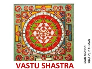
- 1. SALIL MOHAN SHARIQUE AHMAD VASTU SHASTRA
- 2. Vastu Shastra- an inquisitive science of architecture ,encapsulates the forces which act upon a given space through flow of positive energy. Vastu refers to 'abode' or mansion and Shastra or Vidya means science or knowledge, so Vastu Vidya is the sacred holistic science pertaining to designing and building of houses. The principles of vastu have been derived from Sthapathya Vedaone of the ancient sacred books in Hinduism.
- 3. • The world comprises of five basic elements, also known as the Paanchbhootas. They are Earth, Water, Air, Fire and Space. Out of the nine planets, our planet has life because of the presence of these five elements. Vastu Shastra is creating a congenial settings or a place to live or work, in most scientific way taking advantages of the benefits bestowed by these five elements of the nature thereby paving the way for enhanced health, wealth, prosperity and happiness in an enlightened environment.
- 4. North-east (Eshan) is ruled by Sadasiva or God Himself. Hence this direction is paramount, which demands keeping it scrupulously clean, open and highly receptive in a welcome "mode" always. East is ruled by Indra, the chief of the gods, giver of pleasures. The direction also represents the realm of the rising Sun projecting ultra-violet rays, so essential for health in several ways. South-east (Agneya) is the habitat of fire, the storehouse of energy. South is the abode of Yama, the god of death. South-west (Nairitya) is the abode of Putna demoness. West is the abode of Varuna, the god of ocean. It is also the direction of the setting Sun which gives infra-red radiation. North-west (Vayavva) is the abode of air/wind, the invisible, but the most effective blessing for all objects in need of motion/movement for their efficiency. North is the abode of Kuber, the god of wealth.
- 5. • • WATER: Water bodies in north or east are considered good. As far as the flow of domestic water is concerned, it should be borne in mind and that such water should be drained out in North - East. Wells, tubewells, swimming pools etc. should all be in the North-East. The water from the toilets and bathrooms, too, should be drained out in the North- East. The North-East direction is always auspicious and suitable for water. There are sewer-systems in the cities. The Septic tanks or the flow of sewer systems should be towards North - West. The flow of rain or fresh water should be towards NorthEast. FIRE: The direction of Fire is South-East. The Kitchen, fireplace, geysers etc. should be placed only in this direction. Alternatively these could be placed in NorthWest, because it is at 180 degree to South-East. The Vastu Fire Element One can take care of the South-East Corners of all rooms and aim for Hapiness in the family, Good Health, Sound Finances, and Nice Married Life. As South-East belongs to Agni he can create enough trouble for inmates. The South-East corner of every room should be taken care of it. One can keep Agni Vastu Fire Element cheerful by having a spotlight or lantern in the South-East corner with light or burning flame pointing to the roof. One can have the Electrical gadgets like Television, VCR, Fridge, Computer, Fireplace, Microwaves, radio etc placed in South-East corner. • • AIR: The air should enter the building from North -East. All the openings and media for air entry such as doors, windows, ventilators coolers, air-conditioners, verandahs, balconies etc. should be in this directions. SPACE OR OPEN SKY: The open sky influences greatly. We can get the effect of terrestrial-energies uninterruptedly. But the buildings prove a barrier to the effects of open sky. Therefore, the importance of roofs or lawns gets emphasized, but the Vastu shastra has refrained from deliberating in detail over it, because it is related chiefly to building construction and we will discuss only this aspect. Traditionally every house in India used to have an open space (Court Yard) in the center of the house. It provided the dwellers not only the open sky but also sunlight and cross-ventilation
- 6. • • • • • • • • • • • • • • • • • • • EARTH ANGLES OF THE PLOT SW EXACT 90 DEGREE NE LESS THAN 90 DEGREE NW & SE AIR MAY VARY ACCORDINGLY BALCONY N-E COW SHED NW DOOR N-E FLOOR LEVEL NE LOW PORTICO N-E-NE GARAGE NW VERANDAH N-E WINDOWS N-E LAND LEVEL NE LOW BRAHMA STHAN NO MAIN GATE N-E CENTER PILLAR OR BEAM OFFICE NW-W FIRE SERVANT QUARTER NW GEYSER SE OR NW SHAPE OF THE PLOT SQUARE GENERATOR SE OR NW OR RECTANGLE HEATERS SE OR NW STORES NW JUNCTION BOX SE OR NW STUDY ROOM NE KITCHEN (FIRE PLACE) SE OR NW PRESS SE OR NW SEPTIC TANK NW TRANSFORMER SE OR NW URINALS & TOILET W-NW SPACE WATER FACTORY SHED SLOPE SW OR NE RAIN WATER SLOPE NE HEIGHT MORE SW OVER HEAD TANK NW OR W ORMEZANINE FLOOR SW SW MASTER BED ROOM SW UNDER GROUND TANK NE OPEN SPACE MORE NE TUBEWELL NE OR E STAIR CASE SW OR S SHAPE OF PLOT: Favourites are regular shaped square or rectangular plota AND irregular shaped plots are normally avoided. OBSTRUCTION: Obstruction like big trees, open well, pillars and posts before a arrow like roads are to be avoided. IDEAL SITE: A building should be constructed preferably in a square plot the house should be constructed in the for house centre and in rectangular plot it should be nearer to construction south, south west and west sides preferably leaving more in a plot open space on north and east. "L" or Considered not suitable for house as corners will be "U" shaped missing and occupants will be missing opportunities.
- 7. VEDIC SQUARE In ancient Indian mathematics, a Vedic square is a variation on a typical 9 × 9 multiplication table. The entry in each cell is the digital root of the product of the column and row headings i.e. the remainder when the product of the row and column headings is divided by 9 (with remainder 0 represented by 9).
- 8. La Divina Comedia of Dante with the Tower of Babel on the background. This Ziggurat is a Geometric Structure highly related to the Vedic Square. The Sistine Chapel is designed with the Vedic Square. The Patterns of Islamic Art are created out of the Vedic Square
- 9. Vastu Purusha Mandala Vastu purusha mandala is the metaphysical diagrammatic design of cosmos on which the whole concept of Vastu Shastra is based. It is believed that Vastu purusha is lied down on the cosmos which constitutes energies in a way that his head is resting in Northeast direction which represents balanced thinking; lower body facing South-west which represents strength and firmness; his navel is in center of the earth signifying cosmic awareness and holiness; his hand face North-west and South-east which signifies energy.
- 10. JAIPUR • Jaipur was founded on 18th November 1727 by Maharaja Sawai Jai Singh II, a Kachawaha Rajput, who ruled from 1699-1744. Initially his capital was Amber (now pronounced as Amer), lies at a distance of 11 km from Jaipur. Maharaja Sawai Jai Singh II felt the need of shifting his capital city because of safety reasons as it was likely to be attacked by a Mughal King Bahadur Shah after the death of Aurangzeb, as well as ever-increasing population and growing scarcity of water also pushed him to set up a well planned city.
- 11. • • • • • • • • Reasons for Maharaja Sawai Jai Singh to change his capital from Amber to Jaipur: Military Reasons Defence was an important consideration. A site at the South of Amber ensured greater distance from Delhi and also prevented the expansion of the city in that direction. It was clear that the out skirting hill ranges (Nahargarh hills) shaped as a horseshoe would allow the new city to expand only in the South. So this flat site with a basin like shape was chosen. It was an open plain bounded on the north-west and east bay hills. Earlier Rajputs capitals were established in the hills, and so moving capital to the plains was an ex of Sawan Jai Singh's boldness
- 12. Geographical Reasons The rocky terrain of Amber restricted expansion. Jaipur had the potentialities of developing into a city with adequate drinking water due to the presence of a perennial stream nearby and good drainage system. Its rugged hills also ensured a constant supply of building material, which might be required in the times to come Two significant facts responsible for the origin of the city and its subsequent layout: The need of a new capital for 18th century Dhoondhar as the earlier one of Amber built on a hill was getting congested. Sawai Raja Jai Singh’s vision of the new capital as a strong political statement at par with Mughal cities and as a thriving trade and commerce hub for the region. The site with the natural east west ridge and the surrounding forts as defense feature
- 13. • • The town of Jaipur is built in the form of an eight-part "Mandala" known as the "Pithapada". The city was divided into nine blocks, of which two consist the state buildings and palaces, with the remaining seven allotted to the public. Huge fortification walls were made along with seven strong gates for the purpose of security of the city. The city is remarkable among pre-modern Indian cities for the width and regularity of its streets which are laid out into six sectors separated by broad streets of 111 ft. 111 is a holy number in Hinduism and hence considered lucky also. The commercial shops were designed in multiples of nine (27), having one cross street for a planet. "Nine" signifies the nine planets of the ancient astrological zodiac, and twenty-seven signifies the 27 nakshatras. This architectural planning on the basis of Indian Vastu and astronomy is the uniqueness of the architecture of Jaipur.
- 16. • • • • • URBAN FORM AND ARCHITECTURAL IDENTITY ROAD NETWORK Jaipur’s road network follows a definite hierarchy. The major east-west and northsouth road form the sector boundaries and are called Rajmarg as they lead to the city gates. These measure 33m Wide. Next there is a network of 16.5m wide which runs north-south in each sector linking the internal areas of the sectors to the major activity spine. An orthogonal grid of 8.25mx4.00m roads in the prastara-chessboard pattern further divide sectors into Mohallas.
- 17. • • • It is a model of town planning- the first planned city in India. It is based on Hindu systems of town planning and followed the principles prescribed in the Shilpa-shastra, an ancient Indian treatise on architecture .according to this shastra the site should be divided into grids or mandalas rangung from 2x 2 to 10 x 10. Planned according to the Prastara type of layout, which gives prominence to the cardinal directions. Thus plan of jaipur is a grid of 3x3 with gridlines being the city’s main streets.
- 18. • • The urban quarters are further divided by networks of girded streets. Every street is connected to main road. Because of this sort of architecture of Jaipur, nobody can wander in the streets of Jaipur whether he is familiar with the paths or not. Further, the five quarters wrap around the east, south, and the west side of a central palace quarter, with a sixth quarter immediately to the east. Now, Jaipur is clearly divided in two parts, an old "Four Wall City" and a new city; having 5 stars hotels, air port, railway junction, MNCs, internationally recognized colleges, shopping malls, hospitals etc. Architecture of new city is not as per Indian Vastu and astronomy, but the architecture of new Jaipur is based on modern architectural concepts. Its really amazing to have a walk in early morning in old city when traffic is not much and the old architecture of Jaipur can be seen and enjoy easily.
- 19. Entrance Gates of Jaipur • The gates used to be closed at sunset and opened at sunrise. There are only three gates facing East, West, and North, while other gates face South. The Eastern gate of Jaipur is called Suraj (Sun) Pol (also known as Galta Gate), while the Western gate of Jaipur is called Chand (Moon) Pol and the Northern gate of Jaipur is known as Zorawar Singh gate (originally known as Dhruv Pol) which faces toward the ancestral capital of Amber. Other entry gates of Jaipur are known as Gangapol,Krishna Pol (now known as Ajmeri Gate), Ghat Gate (originally known as Ram Pol) and Sanganeri Gate (originally known as Shiv Pol).
- 23. • • • • TIME PERIOD: AROUND 1000 B.C GEOGRAPHICAL LOCATION INDUS VALLEY CIVILIZATION or the Harappan culture forms the earliest urban civilization on the Indian subcontinent. The first site of this civilization discovered HARAPPA IN PUNJAB and MOHENJO-DARO IN SIND now both the sites are in Pakistan. Since then other sites found in Punjab, Kalibangam in Rajasthan, Lothal in Gujarat & Bhanavali in Harayana. The Indus valley civilization was by main river, the Indus River. The river provided irrigation, and also created fertile land for farming.
- 24. TOWN PLANNING • • • • • • • CITADEL towards the west side, fortified by walls on which public buildings were erected. Below the citadel lay a lower town with well settled colonies. The arrangement of the houses in the cities were on the GRID PATTERN. Roads were straight and cuts each other at RIGHT ANGLE. The main street were oriented from north to south and about 30 feet wide dividing the city into large blocks within which networks of narrow lanes are running from east to west. Houses were situated along the roads. The street layout showed an understanding of the basic principles of traffic with ROUNDED CORNERS to allow the turning of carts easily. SEWAGE SYSTEM under the main streets.
- 25. BUILDING LAYOUT • • • • • • Houses were made up of BURNT BRICKS with good quality. The ratio of the brick size was 1:2:4. Every house was furnished with a WELL AND A BATHROOM. Houses were of 2 or more storeys. Planning of a house- SQUARE COURTYARD surrounded by a no. of rooms. The house was planned as a series of rooms opening on to a central courtyard. This courtyard served the multiple functions of lighting the rooms, acting as a heat absorber in summer and radiator in winter, as well as providing an open space inside for community activities. •The entrances were usually with side alleys and no windows faced on the streets. •Floors were made up of bricks, walls were plain outside and inside face is coated with the mud plaster. •Architecture suited to the climate.
- 26. SEWAGE SYSTEM • • Unique sewage system, bathrooms were provided with drains which flow to sewers under the main streets leading to soakpits which finally led the dirty water outside the populated area. The sewers were covered throughout their length by large brick slabs. SEWER DRAINS
- 27. CITADEL HARAPPA AND MOHENJODARO were well planned and thickly populated. • Both the cities were built on a similar plan. • Each city had its own well fortified CITADEL OR ACROPOLIS towards the west which was possibly occupied by the members of the ruling class. • CITADEL •CITADEL was an artificial platform some 30-50FT. HIGH AND ABOUT 400X200YDS. IN AREA, fortified by walls on which public buildings were erected. Below the citadel in each city lay a lower town with well settled colonies.
- 28. GREAT BATH • • • GREAT BATH is a BATHING POOL 39x23x8 feets. Which is said to serve the RITUAL BATHINGS. Around the pool, verandah and rooms were arranged said to be the home of priests. The great bath at mohenjo-daro had WATERPROOFED WITH BITUMEN. The floor of the pool sloped towards AERIAL PHOTOGRAPH OF THE "GREAT the drain pool. BATH" THE ROUND STRUCTURE TO THE LEFT OF THE BATH IS THE WELL. •MASSIVE GRANARY were located near each of the citadels. They were build on a raised platform to avoid floods and was used for storing the grains for the ceremonial purposes, times of shortage.
- 29. ART & SCULPTURES • • • • • The most notable artistic acheivement was perhaps in their seal engravings especially those of ANIMALS, POTTERY AND SCULPTURES. More than 2000 SEALS have been discovered and these formed the main body of the pictoral records of these times. The square seals were generally made up of STEATITE AND COPPER, TERRACOTA AND AGATE. The animals engraved were tiger, buffalow, bull and unicorn. The seals might be considered the first art objects in india.
- 30. • • Sculptural remains were found among which some of the human figures are interesting for e.g- the RED SAND STONE TORSO OF A MAN AND THE BRONZE “DANCING GIRL” WITH A NECKLACE AROUND HER NECK. Harappan pottery was mature they created huge, tall, decorative storage jars, bowls etc. they also produce terracota toys.
- 31. DECLINE OF THE CIVILIZATION • The decline of the indus valley civilization – changing of river system that destructed the agricultural and economics system, invasion of the aryans from the north-west who destructed the daily lives, the decreasing fertility, floods and earthquakes which cause changes in the course of the river indus. IMPACT OF THE HARAPPAN CIVILIZATION ON MODERN TIMES •The impact of harappan culture can be sensed today as it shows the earliest use of networks of urban cities with systematic town planning, extensive brick work, art of writing, standard weights and measures. The practise of ritual bathing are example of continuing traditions of the harappan culture.
- 32. BIBLIOGRAPHY – www.vastushastra.org – www.shilpshastra.com// ht.asp – http://www.indianetzon e.com/48/vastu_sastra_ town_planning.htm