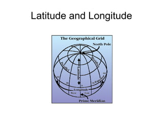
2. Latitude lines run east/west but they measure
north or south of the equator (0°) splitting the earth
into the Northern Hemisphere and Southern
Hemisphere.
3. Latitude
North Pole
South Pole
Lines of
latitude are
numbered
from 0° at
the equator
to 90° N.L.
at the North
Pole.
Lines of
latitude are
numbered
from 0° at
the equator
to 90° S.L.
at the
South Pole.
]
[
90 80
70
60
50
40
20
30
10
90
80
70
60
50
40
20
10
30
4. Latitude
The North Pole
is at 90° N
The South Pole
is at 90° S
The equator
is at 0°
latitude. It
is neither
north nor
south. It is
at the center
between
north and
south.
40° N is the 40°
line of latitude
north of the
equator.
40° S is the 40°
line of latitude
south of the
equator.
5. Longitude
Lines of longitude begin
at the Prime Meridian.
60° W is the
60° line of
longitude west
of the Prime
Meridian.
The Prime Meridian is located at 0°. It is
neither east or west
60° E is the
60° line of
longitude
east of the
Prime
Meridian.
W E
6. Longitude
Lines of longitude are numbered east from the
Prime Meridian to the 180° line and west from
the Prime Meridian to the 180° line.
PRIME MERIDIAN
WestLongitude
EastLongitude
180°
N
EW
S
North Pole
7. Prime Meridian
The Prime Meridian (0°) and the 180° line split the
earth into the Western Hemisphere and Eastern
Hemisphere.
Prime Meridian
Western
Hemisphere
Eastern
Hemisphere
Places located east of the Prime Meridian have an east
longitude (E) address. Places located west of the Prime
Meridian have a west longitude (W) address.
11. Application
N
W E
S
North America is in the Northern Hemisphere because it is
north of the Equator. North America is in the Western
Hemisphere because it is west of the Prime Meridian.
Notas del editor
TEKS: Social Studies – 6.22 (A), Using social studies terminology correctly 7.22 (A), 8.31 (A)
TEKS: Social Studies – 6.22 (A), Using social studies terminology correctly 7.22 (A), 8.31 (A)
TEKS: Social Studies – 6.22 (A), Using social studies terminology correctly 7.22 (A), 8.31 (A)
TEKS: Social Studies – 6.22 (A), Using social studies terminology correctly 7.22 (A), 8.31 (A)
TEKS: Social Studies – 6.22 (A), Using social studies terminology correctly 7.22 (A), 8.31 (A)
If you took a cruise on a ship, circumventing, or traveling around the entire planet, you would experience firsthand a phenomena that would help you understand the importance of an international dateline. An explorer by the name of Ferdinand Magellan did just that in the year 1519. Magellan along with 241 men set out to travel around the entire Earth. These men kept very careful records as they traveled. Yet, when they returned, they found that their calendars were off by one day with the calendars of everyone in their home countries. What happened? How did these men loose an entire day? The day was not lost all at once. It was lost little by little, as the traveled around the Earth. If you stay in one place, a day lasts 24 hours. However, if you travel the opposite direction of the rotation of the Earth, your day will be slightly longer than 24 hours, because you are traveling ahead of the setting sun. If you travel with the rotation of the Earth, your day will be slightly shorter than 24 hours, because you are traveling into the sunset. At any one moment there are actually two days on the Earth at the same time. A new day begins at mid-night on the International Dateline. It travels around the Earth, until 48 hours later it ends back at the International dateline. If you were to travel across the International Dateline, the date would change either forward, or backward. This line actually lies in the middle of a time zone. This means that the hour on the clock would not change, as you crossed over, just the date.
TEKS: Social Studies – 6.3 (B), Posing and answering questions about geographic distributions and patterns 6.22 (A), Using social studies terminology correctly 7.22 (A), 8.31 (A)