SlideShare una empresa de Scribd logo
1 de 15
What is GPS?<br />The Global Positioning System (GPS) is a satellite-based navigation system made up of a network of 24 satellites placed into orbit by the U.S. Department of Defense. GPS was originally intended for military applications, but in the 1980s, the government made the system available for civilian use. GPS works in any weather conditions, anywhere in the world, 24 hours a day. There are no subscription fees or setup charges to use GPS.<br />How GPS Works<br />A GPS receiver must acquire signals from at least four satellites to reliably calculate a three-dimensional position. Ideally, these satellites should be distributed across the sky. The receiver performs mathematical calculations to establish the distance from a satellite, which in turn is used to determine its position. The GPS receiver knows where each satellite is the instant its distance is measured. This position is displayed on the datalogger and saved along with any other descriptive information entered in the field software.<br />Some Limitations<br />GPS can provide worldwide, three-dimensional positions, 24 hours a day, in any type of weather. However, the system does have some limitations. There must be a relatively clear quot;
line of sightquot;
 between the GPS antenna and four or more satellites. Objects, such as buildings, overpasses, and other obstructions, that shield the antenna from a satellite can potentially weaken a satellite's signal such that it becomes too difficult to ensure reliable positioning. These difficulties are particularly prevalent in urban areas. The GPS signal may bounce off nearby objects causing another problem called multipath interference.<br />How accurate is GPS?<br />Today's GPS receivers are extremely accurate, thanks to their parallel multi-channel design. Garmin's 12 parallel channel receivers are quick to lock onto satellites when first turned on and they maintain strong locks, even in dense foliage or urban settings with tall buildings. Certain atmospheric factors and other sources of error can affect the accuracy of GPS receivers. Garmin® GPS receivers are accurate to within 15 meters on average. <br />Newer Garmin GPS receivers with WAAS (Wide Area Augmentation System) capability can improve accuracy to less than three meters on average. No additional equipment or fees are required to take advantage of WAAS. Users can also get better accuracy with Differential GPS (DGPS), which corrects GPS signals to within an average of three to five meters. The U.S. Coast Guard operates the most common DGPS correction service. This system consists of a network of towers that receive GPS signals and transmit a corrected signal by beacon transmitters. In order to get the corrected signal, users must have a differential beacon receiver and beacon antenna in addition to their GPS. <br />The GPS satellite system<br />The 24 satellites that make up the GPS space segment are orbiting the earth about 12,000 miles above us. They are constantly moving, making two complete orbits in less than 24 hours. These satellites are travelling at speeds of roughly 7,000 miles an hour.<br />GPS satellites are powered by solar energy. They have backup batteries onboard to keep them running in the event of a solar eclipse, when there's no solar power. Small rocket boosters on each satellite keep them flying in the correct path.<br />Here are some other interesting facts about the GPS satellites (also called NAVSTAR, the official U.S. Department of Defense name for GPS):<br />The first GPS satellite was launched in 1978.<br />A full constellation of 24 satellites was achieved in 1994.<br />Each satellite is built to last about 10 years. Replacements are constantly being built and launched into orbit.<br />A GPS satellite weighs approximately 2,000 pounds and is about 17 feet across with the solar panels extended.<br />Transmitter power is only 50 watts or less.<br />What's the signal?<br />GPS satellites transmit two low power radio signals, designated L1 and L2. Civilian GPS uses the L1 frequency of 1575.42 MHz in the UHF band. The signals travel by line of sight, meaning they will pass through clouds, glass and plastic but will not go through most solid objects such as buildings and mountains.<br />A GPS signal contains three different bits of information - a pseudorandom code, ephemeris data and almanac data. The pseudorandom code is simply an I.D. code that identifies which satellite is transmitting information. You can view this number on your Garmin GPS unit's satellite page, as it identifies which satellites it's receiving. <br />Ephemeris data, which is constantly transmitted by each satellite, contains important information about the status of the satellite (healthy or unhealthy), current date and time. This part of the signal is essential for determining a position.<br />The almanac data tells the GPS receiver where each GPS satellite should be at any time throughout the day. Each satellite transmits almanac data showing the orbital information for that satellite and for every other satellite in the system.<br />Sources of GPS signal errors<br />Factors that can degrade the GPS signal and thus affect accuracy include the following:<br />Ionosphere and troposphere delays - The satellite signal slows as it passes through the atmosphere. The GPS system uses a built-in model that calculates an average amount of delay to partially correct for this type of error.<br />Signal multipath - This occurs when the GPS signal is reflected off objects such as tall buildings or large rock surfaces before it reaches the receiver. This increases the travel time of the signal, thereby causing errors.<br />Receiver clock errors - A receiver's built-in clock is not as accurate as the atomic clocks onboard the GPS satellites. Therefore, it may have very slight timing errors.<br />Orbital errors - Also known as ephemeris errors, these are inaccuracies of the satellite's reported location.<br />Number of satellites visible - The more satellites a GPS receiver can quot;
see,quot;
 the better the accuracy. Buildings, terrain, electronic interference, or sometimes even dense foliage can block signal reception, causing position errors or possibly no position reading at all. GPS units typically will not work indoors, underwater or underground.<br />Satellite geometry/shading - This refers to the relative position of the satellites at any given time. Ideal satellite geometry exists when the satellites are located at wide angles relative to each other. Poor geometry results when the satellites are located in a line or in a tight grouping.<br />Intentional degradation of the satellite signal - Selective Availability (SA) is an intentional degradation of the signal once imposed by the U.S. Department of Defense. SA was intended to prevent military adversaries from using the highly accurate GPS signals. The government turned off SA in May 2000, which significantly improved the accuracy of civilian GPS receivers.<br />Sources of Errors in GPS<br />Selective Availability<br />The most relevant factor for the inaccuracy of the GPS system is no longer an issue. On May 2, 2000 5:05 am (MEZ) the so-called selective availability (SA) was turned off. Selective availability is an artificial falsification of the time in the L1 signal transmitted by the satellite. For civil GPS receivers that leads to a less accurate position determination (fluctuation of about 50 m during a few minutes). Additionally the ephemeris data are transmitted with lower accuracy, meaning that the transmitted satellite positions do not comply with the actual positions. In this way an inaccuracy of the position of 50 – 150 m can be achieved for several hours. While in times of selective availability the position determination with civil receivers had an accuracy of approximately 10  m, nowadays 20 m or even less is usual. Especially the determination of heights has improved considerably from the deactivation of SA (having been more or less useless before). <br />The reasons for SA were safety concerns. For example terrorists should not be provided with the possibility of locating important buildings with homemade remote control weapons. Paradoxically, during the first gulf war in 1990, SA had to be deactivated partially, as not enough military receivers were available for the American troops. 10000 civil receivers were acquired (Magellan and Trimble instruments), making a very precise orientation possible in a desert with no landmarks. <br />Meanwhile SA is permanently deactivated due to the broad distribution and world wide use of the GPS system.<br />The following two graphs show the improvement of position determination after deactivation of SA. The edge length of the diagrams is 200 m, the data were collected on May 1, 2000 and May 3, 2000 over a period of 24 h each. While with SA 95 % of all points are located within a radius of 45 m, without SA 95 % of all points are within a radius of 6.3 m.<br />Plot of the position determination with and without SA (Diagram from http://www.igeb.gov/sa/diagram.shtml (page no longer available) With friendly permission of Dr. Milbert (NOAA)) <br /> <br />quot;
Satellite geometryquot;
<br />Another factor influencing the accuracy of the position determination is the quot;
satellite geometryquot;
. Simplified, satellite geometry describes the position of the satellites to each other from the view of the receiver. <br />If a receiver sees 4 satellites and all are arranged for example in the north-west, this leads to a “bad” geometry. In the worst case, no position determination is possible at all, when all distance determinations point to the same direction. Even if a position is determined, the error of the positions may be up to 100 – 150 m. If, on the other hand, the 4 satellites are well distributed over the whole firmament the determined position will be much more accurate. Let’s assume the satellites are positioned in the north, east, south and west in 90° steps. Distances can then be measured in four different directions, reflecting a „good“ satellite geometry. <br />The following graph shows this for the two-dimensional case.<br />Good geometrical alignment of two satellites <br />If the two satellites are in an advantageous position, from the view of the receiver they can be seen in an angle of approximately 90° to each other. The signal runtime can not be determined absolutely precise as explained earlier. The possible positions are therefore marked by the grey circles. The point of intersection A of the two circles is a rather small, more or less quadratic field (blue), the determined position will be rather accurate.<br />Bad geometrical alignment of two satellites <br />If the satellites are more or less positioned in one line from the view of the receiver, the plane of intersection of possible positions is considerably larger and elongated- The determination of the position is less accurate. <br />The satellite geometry is also relevant when the receiver is used in vehicles or close to high buildings. If some of the signals are blocked off, the remaining satellites determine the quality of the position determination and if a position fix is possible at all. This can be observed in buildings close to the windows. If a position determination is possible, mostly it is not very accurate. The larger the obscured part of the sky, the more difficult the position determination gets. <br />Most GPS receivers do not only indicate the number of received satellites, but also their position on the firmament. This enables the user to judge, if a relevant satellite is obscured by an obstacle and if changing the position for a couple of meters might improve the accuracy. Many instruments provide a statement of the accuracy of the measured values, mostly based on a combination of different factors (which manufacturer do not willingly reveal).<br />To indicate the quality of the satellite geometry, the DOP values (dilution of precision) are commonly used. Based on which factors are used for the calculation of the DOP values, different variants are distinguished: <br />GDOP (Geometric Dilution Of Precision); Overall-accuracy; 3D-coordinates and time <br />PDOP (Positional Dilution Of Precision) ; Position accuracy; 3D-coordinates <br />HDOP (Horizontal Dilution Of Precision); horizontal accuracy; 2D-coordinates <br />VDOP (Vertical Dilution Of Precision); vertical accuracy; height <br />TDOP (Time Dilution Of Precision); time accuracy; time <br />HDOP-values below 4 are good, above 8 bad. HDOP values become worse if the received satellites are high on the firmament. VDOP values on the other hand become worse the closer the satellites are to the horizon and PDOP values are best if one satellite is positions vertically above and three are evenly distributed close to the horizon. For an accurate position determination, the GDOP value should not be smaller than 5. The PDOP, HDOP and VDOP values are part of the NMEA data sentence $GPGSA. <br />The satellite geometry does not cause inaccuracies in the position determination that can be measured in meters. In fact the DOP values amplify other inaccuracies. High DOP values just amplify other errors more than low DOP values. <br />The error in the position determination caused by the satellite geometry also depends on the latitude of the receiver. This is shown below in the two diagrams. The diagram on the left side shows the inaccuracy of the height (at the beginning of the curve with SA), recorded in Wuhan (China). Wuhan is situated on 30.5° northern latitude were ideal satellite constellation can be found at all time. The graph on the right side shows the same interval recorded by the Casey-Station in the Antarctica (66.3° southern latitude). Due to the satellite constellation from time to time the error is much larger. Additionally the falsification by the atmospheric effect gets more significant the closer the position is to the poles (for an explanation see “atmospheric effects”).<br />Error in the height determination at different latitudes<br /> <br />Satellite Orbits<br />Although the satellites are positioned in very precise orbits, slight shifts of the orbits are possible due to gravitation forces. Sun and moon have a weak influence on the orbits. The orbit data are controlled and corrected regularly and are sent to the receivers in the package of ephemeris data. Therefore the influence on the correctness of the position determination is rather low, the resulting error being not more than 2 m.<br /> <br />Multipath effect<br />Interference caused by reflection of the signals <br />The multipath effect is caused by reflection of satellite signals (radio waves) on objects. It was the same effect that caused ghost images on television when antennae on the roof were still more common instead of todays satellite dishes. <br />For GPS signals this effect mainly appears in the neighbourhood of large buildings or other elevations. The reflected signal takes more time to reach the receiver than the direct signal. The resulting error typically lies in the range of a few meters.<br /> <br />Atmospheric effects<br />Influenced propagation of radio waves through the earth's atmosphere <br />Another source of inaccuracy is the reduced speed of propagation in the troposphere and ionosphere. While radio signals travel with the velocity of light in the outer space, their propagation in the ionosphere and troposphere is slower. <br />In the ionosphere in a height of 80 – 400 km a large number of electrons and positive charged ions are formed by the ionizing force of the sun. The electrons and ions are concentrated in four conductive layers in the ionosphere (D-, E-, F1-, and F2-layer). These layers refract the electromagnetic waves from the satellites, resulting in an elongated runtime of the signals. <br />These errors are mostly corrected by the receiver by calculations. The typical variations of the velocity while passing the ionosphere for low and high frequencies are well known for standard conditions. Theses variations are taken into account for all calculations of positions. However civil receivers are not capable of correcting unforeseen runtime changes, for example by strong solar winds.<br />It is known that electromagnetic waves are slowed down inversely proportional to the square of their frequency (1/f2) while passing the ionosphere. This means that electromagnetic waves with lower frequencies are slowed down more than electromagnetic waves with higher frequencies. If the signals of higher and lower frequencies which reach a receiver are analysed with regard to their differing time of arrival, the ionospheric runtime elongation can be calculated. Military GPS receivers use the signals of both frequencies (L1 and L2) which are influenced in different ways by the ionosphere and are able to eliminate another inaccuracy by calculation. <br />The tropospheric effect is a further factor elongating the runtime of electromagnetic waves by refraction. The reasons for the refraction are different concentrations of water vapour in the troposphere, caused by different weather conditions. The error caused that way is smaller than the ionospheric error, but can not be eliminated by calculation. It can only be approximated by a general calculation model. <br />The following two graphs visualize the ionospheric error. The left data were collected with a one-frequency receiver without ionospheric correction, the right data were collected with a two-frequency receiver with ionospheric correction. Both diagrams have approximately the same scale (Left: latitude -15 m to +10 m, longitude -10 m to +20 m, Right: latitude -12 m to +8 m, longitude -10 m to +20 m). The right graph clearly shows less outliers, while the mean accuracy of the position for 95 % of the data is not considerably enhanced by the correction of the ionospheric error.<br />Position determination without and with atmospheric corrections by using the second frequency on a dual-frequency receiver<br />With the implementation of WAAS and EGNOS it s possible to set up „maps“ of the atmospheric conditions over different regions. The correction data are sent to the receivers, enhancing the accuracy considerably.<br /> <br />Clock inaccuracies and rounding errors<br />Despite the synchronization of the receiver clock with the satellite time during the position determination, the remaining inaccuracy of the time still leads to an error of about 2 m in the position determination. Rounding and calculation errors of the receiver sum up approximately to 1 m.<br /> <br />Relativistic effects<br />The following section shall not provide a comprehensive explanation of the theory of relativity. In the normal life we are quite unaware of the omnipresence of the theory of relativity. However it has an influence on many processes, among them is the proper functioning of the GPS system. This influence will be explained shortly in the following. <br />As we already learned, the time is a relevant factor in GPS navigation and must be accurate to 20 - 30 nanoseconds to ensure the necessary accuracy. Therefore the fast movement of the satellites themselves (nearly 12000 km/h) must be considered. <br />Whoever already dealt with the theory of relativity knows that time runs slower during very fast movements. For satellites moving with a speed of 3874 m/s, clocks run slower when viewed from earth. This relativistic time dilation leads to an inaccuracy of time of approximately 7,2 microseconds per day (1 microsecond = 10-6 seconds). <br />The theory of relativity also says that time moves the slower the stronger the field of gravitation is. For an observer on the earth surface the clock on board of a satellite is running faster (as the satellite in 20000 km height is exposed to a much weaker field of gravitation than the observer). And this second effect is six times stronger than the time dilation explained above. <br />Altogether, the clocks of the satellites seem to run a little faster. The shift of time to the observer on earth would be about 38 milliseconds per day and would make up for an total error of approximately 10 km per day. In order that those error do not have to be corrected constantly, the clocks of the satellites were set to 10.229999995453 Mhz instead of 10.23 Mhz but they are operated as if they had 10.23 MHz. By this trick the relativistic effects are compensated once and for all.<br />There is another relativistic effect, which is not considered for normal position determinations by GPS. It is called Sagnac-Effect and is caused by the movement of the observer on the earth surface, who also moves with a velocity of up to 500 m/s (at the equator) due to the rotation of the globe. The influence of this effect is very small and complicate to calculate as it depends on the directions of the movement. Therefore it is only considered in special cases.<br />The errors of the GPS system are summarized in the following table. The individual values are no constant values, but are subject to variances. All numbers are approximative values. <br />Ionospheric effects ± 5 metersShifts in the satellite orbits ± 2.5 meterClock errors of the satellites' clocks ± 2 meterMultipath effect ± 1 meterTropospheric effects± 0.5 meterCalculation- und rounding errors ± 1 meter<br /> <br />Altogether this sums up to an error of ± 15 meters. With the SA still activated, the error was in the range of ± 100 Meter. Corrections by systems like WAAS and EGNOS, which mainly reduce ionospheric effects, but also improve orbits and clock errors, the overall error is reduced to approximately ± 3 - 5 meters.<br />Choice of the carrier frequency<br />To transport data signals, a suitable carrier frequency is required. The choice of the carrier frequency is submitted to the following requirements:<br />Frequencies should be chosen below 2 GHz, as frequencies above 2 GHz would require beam antennae for the signal reception<br />Ionospheric delays are enormous for frequency rages below 100 MHz and above 10 GHz<br />The speed of propagation of electromagnetic waves in media like air deviates from the speed of light (in vacuum) the more, the lower the frequency is. For low frequencies the runtime is falsified.<br />he PRN-codes (explained below) require a high bandwidth for the code modulation on the carrier frequency. Therefore a range of high frequencies with the possibility of a high bandwidth has to be chosen.<br />The chosen frequency should be in a range where the signal propagation is not influenced by weather phenomena like, rain, snow or clouds.<br />Based on these considerations, the choice of two frequencies proved to be advantageous.Each GPS satellite transmits two carrier signals in the microwave range, designated as L1 and L2 (frequencies located in the L-Band between 1000 and 2000 MHz).Civil GPS receivers use the L1 frequency with 1575.42 MHz (wavelength 19.05 cm). The L1 frequency carries the navigation data as well as the SPS code (standard positioning code). The L2 frequency (1227.60 MHz, wavelength 24.45 cm) only carries the P code and is only used by receivers which are designed for PPS (precision positioning code). Mostly this can be found in military receivers.<br /> <br />Modulation of the carrier signals<br />C/A and P-Code<br />The carrier phases are modulated by three different binary codes: first there is the C/A code (coarse acquisition). This code is a 1023 “chip” long code, being transmitted with a frequency of 1.023 MHz. A “chip” is the same as a “bit”, and is described by the numbers “one” or “zero”. The name “chip” is used instead of “bit” because no information is carried by the signal. By this code the carrier signals are modulated and the bandwidth of the man frequency band is spread from 2 MHz to 20 MHz (spread spectrum). Thus the interference liability is reduced.The C/A code is a pseudo random code (PRN) which looks like a random code but is clearly defined for each satellite. It is repeated every 1023 bits or every millisecond. Therefore each second 1023000 chips are generated. Taking into account the speed of light the length of one chip can be calculated to be 300 m.<br /> <br />Pseudo Random Numbers (PRNs)<br />The satellites are identified by the receiver by means of PRN-numbers. Real GPS satellites are numbered from 1 – 32. To WAAS/EGNOS satellites and other pseudolites higher numbers are assigned. These PRN-numbers of the satellites appear on the satellite view screens of many GPS receivers. For simplification of the satellite network 32 different PRN-numbers are available, although only 24 satellites were necessary and planned in the beginning. For a couple of years, now more than 24 satellites are active, which optimizes the availability, reliability and accuracy of the network.<br />The mentioned PRN-codes are only pseudo random. If the codes were actually random, 21023 possibilities would exist. Of these many codes only few are suitable for the auto correlation or cross correlation which is necessary for the measurment of the signal propagation time. The 37 suitable codes are referred to as GOLD-codes (names after a mathematician). For these GOLD-codes the correlation among each other is particularly weak, making an unequivocal identification possible.<br />The C/A code is the base for all civil GPS receivers. The P code (p = precise) modulates the L1 as well as the L2 carrier frequency and is a very long 10.23 MHz pseudo random code. The code would be 266 days long, but only 7 days are used.For protection against interfering signals transmitted by an possible enemy, the P-code can be transmitted encrypted. During this anti-spoofing (AS) mode the P-code is encrypted in a Y-code. The encrypted code needs a special AS-module for each receiving channel and is only accessible for authorized personnel in possession of a special key. The P- and Y-code are the base for the precise (military) position determination. Since January 31, 1994 the AS-system is operating continiously and the P-code is only transmitted as Y-code.<br /> <br />Transmission of data<br />In the GPS system data are modulated onto the carrier signal by means of phase modulations. Phase modulation is a rarely used technique, compared to amplitude modulation (AM) or frequency modulation. In the following, these three modulation techniques shall be explained shortly.<br /> <br />Amplitude modulation<br />Amplitude modulation of a data signal onto a carrier signal <br />For the amplitude modulation the amplitude, which corresponds to the strength of the signal, is changed in accordance to the data signal that shall be transported. If this principle would be applied to sound waves, the sound level would change in order to transport a signal. With increasing attenuation it becomes more and more difficult to filter the data from the signal. This kind of modulation is known from AM radio (that's what AM stands for: amplitude modulation).<br /> <br />Frequency modulation<br />Frequency modulation of a data signal onto a carrier <br />For the frequency modulation, the carrier frequency itself is changed by modulating the data signal onto it. If we stay with the example of the sound waves, the pitch of the tones would be changed while the volume would be kept constant. Frequency modulated signals are less susceptible for disturbances and provides a higher bandwidth than AM modulation. This kind of modulation is used for FM radio.<br /> Phase modulation<br />Phase modulation of a data signal onto a carrier <br />When a data signal shall be modulated onto a carrier signal by phase modulation, the sine oscillation of the carrier signal is interrupted and restarted with a phase shift of e.g. 180°. This phase shift can be recognized by a suitable receiver and the data can be restored. Phase modulation leads to an extension of the frequency range of the carrier signal (leading to a spread spectrum) depending on how often the phase is shifted. When the phase changes, wave peaks are followed by wave minimums in a shorter distance than were in the original carrier signal (as can be seen in the graph).This kind of modulation can only be used for the transmission of digital data.<br />The following graph shows the composition of signals which are transmitted by GPS-satellites. The setup of the NAV/System data is explained in the chapter quot;
data signal compositionquot;
.<br />Composition of the signals from GPS satellites<br />Remark: Modulo 2 Sum means that sums are formed according to arithmetic rules. If the result is larger than 2, only the rest is kept which can not be divided by 2 (0+0=0; 0+1=1; 1+0=1; 1+1=0).<br />
Gps
Gps
Gps
Gps
Gps
Gps
Gps
Gps
Gps
Gps
Gps
Gps
Gps
Gps

Más contenido relacionado

La actualidad más candente

Global Positioning System (GPS) in Helthcare
Global Positioning System (GPS) in HelthcareGlobal Positioning System (GPS) in Helthcare
Global Positioning System (GPS) in HelthcareZulfiquer Ahmed Amin
 
Introduction to gps [compatibility mode]
Introduction to gps [compatibility mode]Introduction to gps [compatibility mode]
Introduction to gps [compatibility mode]Sumanta Das
 
GPS (GLOBAL POSITIONING SYSTEM)
GPS (GLOBAL POSITIONING SYSTEM)GPS (GLOBAL POSITIONING SYSTEM)
GPS (GLOBAL POSITIONING SYSTEM)Abdul mannan Karim
 
Introduction to the Global Positioning System
Introduction to the Global Positioning SystemIntroduction to the Global Positioning System
Introduction to the Global Positioning SystemNingeni sionmosesaam
 
Global positioning system (GPS)
Global positioning system (GPS)Global positioning system (GPS)
Global positioning system (GPS)Henil Shah
 
Global positioning system (gps)
Global positioning  system (gps)Global positioning  system (gps)
Global positioning system (gps)Vandana Verma
 
Introduction to GPS
Introduction to GPSIntroduction to GPS
Introduction to GPSDaniel Kim
 
Global Positioning System
Global Positioning System Global Positioning System
Global Positioning System Varun B P
 
Global positioning system (GPS)
Global positioning system (GPS)Global positioning system (GPS)
Global positioning system (GPS)Chandana R
 
Presentation on GPS by Harvendra Singh
Presentation on GPS by Harvendra SinghPresentation on GPS by Harvendra Singh
Presentation on GPS by Harvendra SinghSelf employed
 
Gps( global positioning system) 2010
Gps( global positioning system) 2010Gps( global positioning system) 2010
Gps( global positioning system) 2010Mohamed _el_shora
 
558215 634216980498557500
558215 634216980498557500558215 634216980498557500
558215 634216980498557500Rahul Mundra
 
CE6404 ANNA UNIVERSITY Unit iv gps surveying
CE6404 ANNA UNIVERSITY Unit iv gps surveyingCE6404 ANNA UNIVERSITY Unit iv gps surveying
CE6404 ANNA UNIVERSITY Unit iv gps surveyingDr Gopikrishnan T
 

La actualidad más candente (20)

Global Positioning System
Global Positioning SystemGlobal Positioning System
Global Positioning System
 
Seminar
SeminarSeminar
Seminar
 
Global Positioning System (GPS) in Helthcare
Global Positioning System (GPS) in HelthcareGlobal Positioning System (GPS) in Helthcare
Global Positioning System (GPS) in Helthcare
 
GPS application soil survey
GPS application soil surveyGPS application soil survey
GPS application soil survey
 
Introduction to gps [compatibility mode]
Introduction to gps [compatibility mode]Introduction to gps [compatibility mode]
Introduction to gps [compatibility mode]
 
GPS (GLOBAL POSITIONING SYSTEM)
GPS (GLOBAL POSITIONING SYSTEM)GPS (GLOBAL POSITIONING SYSTEM)
GPS (GLOBAL POSITIONING SYSTEM)
 
Introduction to the Global Positioning System
Introduction to the Global Positioning SystemIntroduction to the Global Positioning System
Introduction to the Global Positioning System
 
GPS introduction
GPS introductionGPS introduction
GPS introduction
 
Global positioning system (GPS)
Global positioning system (GPS)Global positioning system (GPS)
Global positioning system (GPS)
 
Global positioning system (gps)
Global positioning  system (gps)Global positioning  system (gps)
Global positioning system (gps)
 
Introduction to GPS
Introduction to GPSIntroduction to GPS
Introduction to GPS
 
Global Positioning System
Global Positioning System Global Positioning System
Global Positioning System
 
Global positioning system (GPS)
Global positioning system (GPS)Global positioning system (GPS)
Global positioning system (GPS)
 
Presentation on GPS by Harvendra Singh
Presentation on GPS by Harvendra SinghPresentation on GPS by Harvendra Singh
Presentation on GPS by Harvendra Singh
 
Gps( global positioning system) 2010
Gps( global positioning system) 2010Gps( global positioning system) 2010
Gps( global positioning system) 2010
 
Gps 1
Gps 1Gps 1
Gps 1
 
GPS IN AVIATION SYSTEM
GPS IN AVIATION SYSTEMGPS IN AVIATION SYSTEM
GPS IN AVIATION SYSTEM
 
558215 634216980498557500
558215 634216980498557500558215 634216980498557500
558215 634216980498557500
 
CE6404 ANNA UNIVERSITY Unit iv gps surveying
CE6404 ANNA UNIVERSITY Unit iv gps surveyingCE6404 ANNA UNIVERSITY Unit iv gps surveying
CE6404 ANNA UNIVERSITY Unit iv gps surveying
 
Gps surveying
Gps surveyingGps surveying
Gps surveying
 

Destacado

مذكرات المشير محمد عبد الغني الجمسي رئيس هيئة عمليات القوات المسلحة
مذكرات المشير محمد عبد الغني الجمسي رئيس هيئة عمليات القوات المسلحةمذكرات المشير محمد عبد الغني الجمسي رئيس هيئة عمليات القوات المسلحة
مذكرات المشير محمد عبد الغني الجمسي رئيس هيئة عمليات القوات المسلحةHossam Zein
 
بروتوكولات حكماء صهيون
بروتوكولات حكماء صهيون بروتوكولات حكماء صهيون
بروتوكولات حكماء صهيون Hossam Zein
 
Radar fundamentals
Radar fundamentalsRadar fundamentals
Radar fundamentalsHossam Zein
 
Hossam Ahmed Zein
Hossam Ahmed ZeinHossam Ahmed Zein
Hossam Ahmed ZeinHossam Zein
 
3 d tv proadcasting
3 d tv proadcasting3 d tv proadcasting
3 d tv proadcastingHossam Zein
 
sonnen solar tracker 1/2
sonnen solar tracker 1/2sonnen solar tracker 1/2
sonnen solar tracker 1/2Hossam Zein
 
مذكرات حرب أكتوبر للفريق سعد الدين الشاذلي رئيس أركان القوات المسلحة
مذكرات حرب أكتوبر للفريق سعد الدين الشاذلي رئيس أركان القوات المسلحةمذكرات حرب أكتوبر للفريق سعد الدين الشاذلي رئيس أركان القوات المسلحة
مذكرات حرب أكتوبر للفريق سعد الدين الشاذلي رئيس أركان القوات المسلحةHossam Zein
 
الحلقة الأولى
الحلقة الأولىالحلقة الأولى
الحلقة الأولىHossam Zein
 
Spread spectrum communications and CDMA
Spread spectrum communications and CDMASpread spectrum communications and CDMA
Spread spectrum communications and CDMAHossam Zein
 
fbx-t radar element of global defence system thaad
fbx-t radar element of global defence system thaadfbx-t radar element of global defence system thaad
fbx-t radar element of global defence system thaadHossam Zein
 
Anti stealth technology
Anti stealth technologyAnti stealth technology
Anti stealth technologyHossam Zein
 
Graduation projects
Graduation projectsGraduation projects
Graduation projectsHossam Zein
 
visible light communication
visible light communicationvisible light communication
visible light communicationHossam Zein
 

Destacado (18)

مذكرات المشير محمد عبد الغني الجمسي رئيس هيئة عمليات القوات المسلحة
مذكرات المشير محمد عبد الغني الجمسي رئيس هيئة عمليات القوات المسلحةمذكرات المشير محمد عبد الغني الجمسي رئيس هيئة عمليات القوات المسلحة
مذكرات المشير محمد عبد الغني الجمسي رئيس هيئة عمليات القوات المسلحة
 
Nano vlsi new
Nano vlsi newNano vlsi new
Nano vlsi new
 
Gps
GpsGps
Gps
 
بروتوكولات حكماء صهيون
بروتوكولات حكماء صهيون بروتوكولات حكماء صهيون
بروتوكولات حكماء صهيون
 
Radar fundamentals
Radar fundamentalsRadar fundamentals
Radar fundamentals
 
Hossam Ahmed Zein
Hossam Ahmed ZeinHossam Ahmed Zein
Hossam Ahmed Zein
 
3 d tv proadcasting
3 d tv proadcasting3 d tv proadcasting
3 d tv proadcasting
 
sonnen solar tracker 1/2
sonnen solar tracker 1/2sonnen solar tracker 1/2
sonnen solar tracker 1/2
 
مذكرات حرب أكتوبر للفريق سعد الدين الشاذلي رئيس أركان القوات المسلحة
مذكرات حرب أكتوبر للفريق سعد الدين الشاذلي رئيس أركان القوات المسلحةمذكرات حرب أكتوبر للفريق سعد الدين الشاذلي رئيس أركان القوات المسلحة
مذكرات حرب أكتوبر للفريق سعد الدين الشاذلي رئيس أركان القوات المسلحة
 
الحلقة الأولى
الحلقة الأولىالحلقة الأولى
الحلقة الأولى
 
Projects ideas
Projects ideasProjects ideas
Projects ideas
 
Spread spectrum communications and CDMA
Spread spectrum communications and CDMASpread spectrum communications and CDMA
Spread spectrum communications and CDMA
 
fbx-t radar element of global defence system thaad
fbx-t radar element of global defence system thaadfbx-t radar element of global defence system thaad
fbx-t radar element of global defence system thaad
 
microprocessors
microprocessorsmicroprocessors
microprocessors
 
Anti stealth technology
Anti stealth technologyAnti stealth technology
Anti stealth technology
 
How gps works
How gps worksHow gps works
How gps works
 
Graduation projects
Graduation projectsGraduation projects
Graduation projects
 
visible light communication
visible light communicationvisible light communication
visible light communication
 

Similar a Gps (20)

Global Positioning System
Global Positioning SystemGlobal Positioning System
Global Positioning System
 
Gps
GpsGps
Gps
 
gps technology
gps technologygps technology
gps technology
 
Gps device in the geological field mapping
Gps device in the geological field mappingGps device in the geological field mapping
Gps device in the geological field mapping
 
Yarab
YarabYarab
Yarab
 
Gps
GpsGps
Gps
 
Gps
GpsGps
Gps
 
Global positioning system (Gps)
Global positioning system (Gps)Global positioning system (Gps)
Global positioning system (Gps)
 
GPS.ppt
GPS.pptGPS.ppt
GPS.ppt
 
Global positioningsystem
Global positioningsystemGlobal positioningsystem
Global positioningsystem
 
ECDIS NAVIGATION 5
ECDIS NAVIGATION 5ECDIS NAVIGATION 5
ECDIS NAVIGATION 5
 
Gps Niladri
Gps NiladriGps Niladri
Gps Niladri
 
Global positioning system
Global positioning systemGlobal positioning system
Global positioning system
 
Gps
GpsGps
Gps
 
Gps
GpsGps
Gps
 
GPS (Global Positioning System)
GPS (Global Positioning System)GPS (Global Positioning System)
GPS (Global Positioning System)
 
Gps final main
Gps final mainGps final main
Gps final main
 
Intro of Differential GPS.pptx
Intro of Differential GPS.pptxIntro of Differential GPS.pptx
Intro of Differential GPS.pptx
 
Global positioning system(GPS)
Global positioning system(GPS)Global positioning system(GPS)
Global positioning system(GPS)
 
Seminar Report For GPS Technology
Seminar Report For GPS TechnologySeminar Report For GPS Technology
Seminar Report For GPS Technology
 

Más de Hossam Zein

the engins that power the future.
the engins that power the future.the engins that power the future.
the engins that power the future.Hossam Zein
 
Options for optimizing combined cycle plants
Options for optimizing combined cycle plantsOptions for optimizing combined cycle plants
Options for optimizing combined cycle plantsHossam Zein
 
Improve plant heat rate with feedwater heater control
Improve plant heat rate with feedwater heater controlImprove plant heat rate with feedwater heater control
Improve plant heat rate with feedwater heater controlHossam Zein
 
01 nuclear energy_overview
01 nuclear energy_overview01 nuclear energy_overview
01 nuclear energy_overviewHossam Zein
 
00 history of_nuclear_fission_short_vers
00 history of_nuclear_fission_short_vers00 history of_nuclear_fission_short_vers
00 history of_nuclear_fission_short_versHossam Zein
 
LMFBR - Superphenix
LMFBR - SuperphenixLMFBR - Superphenix
LMFBR - SuperphenixHossam Zein
 
Climate change-implications-for-the-energy-sector-summary-from-ipcc-ar5-2014-...
Climate change-implications-for-the-energy-sector-summary-from-ipcc-ar5-2014-...Climate change-implications-for-the-energy-sector-summary-from-ipcc-ar5-2014-...
Climate change-implications-for-the-energy-sector-summary-from-ipcc-ar5-2014-...Hossam Zein
 
امن الطاقة والبني التختيه في ضوء التخديات الخالية
امن الطاقة والبني التختيه في ضوء التخديات الخاليةامن الطاقة والبني التختيه في ضوء التخديات الخالية
امن الطاقة والبني التختيه في ضوء التخديات الخاليةHossam Zein
 
Development of of power plants functionality
Development of of power plants functionality Development of of power plants functionality
Development of of power plants functionality Hossam Zein
 
Estimating appliance and home electronic energy use
Estimating appliance and home electronic energy useEstimating appliance and home electronic energy use
Estimating appliance and home electronic energy useHossam Zein
 
3 things to consider when installing solar power at home
3 things to consider when installing solar power at home3 things to consider when installing solar power at home
3 things to consider when installing solar power at homeHossam Zein
 
Planning and Zoning for Solar in North Carolina - Pandzsolar2014
Planning and Zoning for Solar  in North Carolina - Pandzsolar2014Planning and Zoning for Solar  in North Carolina - Pandzsolar2014
Planning and Zoning for Solar in North Carolina - Pandzsolar2014Hossam Zein
 
SolTrK_data_sheet solar control
SolTrK_data_sheet solar controlSolTrK_data_sheet solar control
SolTrK_data_sheet solar controlHossam Zein
 
sonnen solar tracker 2
sonnen solar tracker 2sonnen solar tracker 2
sonnen solar tracker 2Hossam Zein
 
SMA - SUNNY DESIGN 3 and SUNNY DESIGN WEB
SMA - SUNNY DESIGN 3 and SUNNY DESIGN WEBSMA - SUNNY DESIGN 3 and SUNNY DESIGN WEB
SMA - SUNNY DESIGN 3 and SUNNY DESIGN WEBHossam Zein
 
Solar Power Analysis and Design Specifications Houston solar
Solar Power Analysis and  Design Specifications Houston solarSolar Power Analysis and  Design Specifications Houston solar
Solar Power Analysis and Design Specifications Houston solarHossam Zein
 
Terminal High Altitude Area Defense THAAD
Terminal High Altitude Area Defense THAAD Terminal High Altitude Area Defense THAAD
Terminal High Altitude Area Defense THAAD Hossam Zein
 
multi mission radar (MMR) - EL/M-2084 FOR IRON DOME
multi mission radar (MMR) - EL/M-2084 FOR IRON DOMEmulti mission radar (MMR) - EL/M-2084 FOR IRON DOME
multi mission radar (MMR) - EL/M-2084 FOR IRON DOMEHossam Zein
 
القبـة الحـديديـة | IRon DoMe
القبـة الحـديديـة | IRon DoMeالقبـة الحـديديـة | IRon DoMe
القبـة الحـديديـة | IRon DoMeHossam Zein
 
THE EGYPTIAN MILITARY AND the arab Israeli Military balance CSIS report 2000
  THE EGYPTIAN MILITARY AND the arab Israeli Military balance CSIS report 2000  THE EGYPTIAN MILITARY AND the arab Israeli Military balance CSIS report 2000
THE EGYPTIAN MILITARY AND the arab Israeli Military balance CSIS report 2000Hossam Zein
 

Más de Hossam Zein (20)

the engins that power the future.
the engins that power the future.the engins that power the future.
the engins that power the future.
 
Options for optimizing combined cycle plants
Options for optimizing combined cycle plantsOptions for optimizing combined cycle plants
Options for optimizing combined cycle plants
 
Improve plant heat rate with feedwater heater control
Improve plant heat rate with feedwater heater controlImprove plant heat rate with feedwater heater control
Improve plant heat rate with feedwater heater control
 
01 nuclear energy_overview
01 nuclear energy_overview01 nuclear energy_overview
01 nuclear energy_overview
 
00 history of_nuclear_fission_short_vers
00 history of_nuclear_fission_short_vers00 history of_nuclear_fission_short_vers
00 history of_nuclear_fission_short_vers
 
LMFBR - Superphenix
LMFBR - SuperphenixLMFBR - Superphenix
LMFBR - Superphenix
 
Climate change-implications-for-the-energy-sector-summary-from-ipcc-ar5-2014-...
Climate change-implications-for-the-energy-sector-summary-from-ipcc-ar5-2014-...Climate change-implications-for-the-energy-sector-summary-from-ipcc-ar5-2014-...
Climate change-implications-for-the-energy-sector-summary-from-ipcc-ar5-2014-...
 
امن الطاقة والبني التختيه في ضوء التخديات الخالية
امن الطاقة والبني التختيه في ضوء التخديات الخاليةامن الطاقة والبني التختيه في ضوء التخديات الخالية
امن الطاقة والبني التختيه في ضوء التخديات الخالية
 
Development of of power plants functionality
Development of of power plants functionality Development of of power plants functionality
Development of of power plants functionality
 
Estimating appliance and home electronic energy use
Estimating appliance and home electronic energy useEstimating appliance and home electronic energy use
Estimating appliance and home electronic energy use
 
3 things to consider when installing solar power at home
3 things to consider when installing solar power at home3 things to consider when installing solar power at home
3 things to consider when installing solar power at home
 
Planning and Zoning for Solar in North Carolina - Pandzsolar2014
Planning and Zoning for Solar  in North Carolina - Pandzsolar2014Planning and Zoning for Solar  in North Carolina - Pandzsolar2014
Planning and Zoning for Solar in North Carolina - Pandzsolar2014
 
SolTrK_data_sheet solar control
SolTrK_data_sheet solar controlSolTrK_data_sheet solar control
SolTrK_data_sheet solar control
 
sonnen solar tracker 2
sonnen solar tracker 2sonnen solar tracker 2
sonnen solar tracker 2
 
SMA - SUNNY DESIGN 3 and SUNNY DESIGN WEB
SMA - SUNNY DESIGN 3 and SUNNY DESIGN WEBSMA - SUNNY DESIGN 3 and SUNNY DESIGN WEB
SMA - SUNNY DESIGN 3 and SUNNY DESIGN WEB
 
Solar Power Analysis and Design Specifications Houston solar
Solar Power Analysis and  Design Specifications Houston solarSolar Power Analysis and  Design Specifications Houston solar
Solar Power Analysis and Design Specifications Houston solar
 
Terminal High Altitude Area Defense THAAD
Terminal High Altitude Area Defense THAAD Terminal High Altitude Area Defense THAAD
Terminal High Altitude Area Defense THAAD
 
multi mission radar (MMR) - EL/M-2084 FOR IRON DOME
multi mission radar (MMR) - EL/M-2084 FOR IRON DOMEmulti mission radar (MMR) - EL/M-2084 FOR IRON DOME
multi mission radar (MMR) - EL/M-2084 FOR IRON DOME
 
القبـة الحـديديـة | IRon DoMe
القبـة الحـديديـة | IRon DoMeالقبـة الحـديديـة | IRon DoMe
القبـة الحـديديـة | IRon DoMe
 
THE EGYPTIAN MILITARY AND the arab Israeli Military balance CSIS report 2000
  THE EGYPTIAN MILITARY AND the arab Israeli Military balance CSIS report 2000  THE EGYPTIAN MILITARY AND the arab Israeli Military balance CSIS report 2000
THE EGYPTIAN MILITARY AND the arab Israeli Military balance CSIS report 2000
 

Último

microwave assisted reaction. General introduction
microwave assisted reaction. General introductionmicrowave assisted reaction. General introduction
microwave assisted reaction. General introductionMaksud Ahmed
 
Paris 2024 Olympic Geographies - an activity
Paris 2024 Olympic Geographies - an activityParis 2024 Olympic Geographies - an activity
Paris 2024 Olympic Geographies - an activityGeoBlogs
 
mini mental status format.docx
mini    mental       status     format.docxmini    mental       status     format.docx
mini mental status format.docxPoojaSen20
 
Interactive Powerpoint_How to Master effective communication
Interactive Powerpoint_How to Master effective communicationInteractive Powerpoint_How to Master effective communication
Interactive Powerpoint_How to Master effective communicationnomboosow
 
Disha NEET Physics Guide for classes 11 and 12.pdf
Disha NEET Physics Guide for classes 11 and 12.pdfDisha NEET Physics Guide for classes 11 and 12.pdf
Disha NEET Physics Guide for classes 11 and 12.pdfchloefrazer622
 
Student login on Anyboli platform.helpin
Student login on Anyboli platform.helpinStudent login on Anyboli platform.helpin
Student login on Anyboli platform.helpinRaunakKeshri1
 
Russian Call Girls in Andheri Airport Mumbai WhatsApp 9167673311 💞 Full Nigh...
Russian Call Girls in Andheri Airport Mumbai WhatsApp  9167673311 💞 Full Nigh...Russian Call Girls in Andheri Airport Mumbai WhatsApp  9167673311 💞 Full Nigh...
Russian Call Girls in Andheri Airport Mumbai WhatsApp 9167673311 💞 Full Nigh...Pooja Nehwal
 
APM Welcome, APM North West Network Conference, Synergies Across Sectors
APM Welcome, APM North West Network Conference, Synergies Across SectorsAPM Welcome, APM North West Network Conference, Synergies Across Sectors
APM Welcome, APM North West Network Conference, Synergies Across SectorsAssociation for Project Management
 
Mastering the Unannounced Regulatory Inspection
Mastering the Unannounced Regulatory InspectionMastering the Unannounced Regulatory Inspection
Mastering the Unannounced Regulatory InspectionSafetyChain Software
 
Q4-W6-Restating Informational Text Grade 3
Q4-W6-Restating Informational Text Grade 3Q4-W6-Restating Informational Text Grade 3
Q4-W6-Restating Informational Text Grade 3JemimahLaneBuaron
 
Grant Readiness 101 TechSoup and Remy Consulting
Grant Readiness 101 TechSoup and Remy ConsultingGrant Readiness 101 TechSoup and Remy Consulting
Grant Readiness 101 TechSoup and Remy ConsultingTechSoup
 
Measures of Central Tendency: Mean, Median and Mode
Measures of Central Tendency: Mean, Median and ModeMeasures of Central Tendency: Mean, Median and Mode
Measures of Central Tendency: Mean, Median and ModeThiyagu K
 
A Critique of the Proposed National Education Policy Reform
A Critique of the Proposed National Education Policy ReformA Critique of the Proposed National Education Policy Reform
A Critique of the Proposed National Education Policy ReformChameera Dedduwage
 
CARE OF CHILD IN INCUBATOR..........pptx
CARE OF CHILD IN INCUBATOR..........pptxCARE OF CHILD IN INCUBATOR..........pptx
CARE OF CHILD IN INCUBATOR..........pptxGaneshChakor2
 
Separation of Lanthanides/ Lanthanides and Actinides
Separation of Lanthanides/ Lanthanides and ActinidesSeparation of Lanthanides/ Lanthanides and Actinides
Separation of Lanthanides/ Lanthanides and ActinidesFatimaKhan178732
 
Z Score,T Score, Percential Rank and Box Plot Graph
Z Score,T Score, Percential Rank and Box Plot GraphZ Score,T Score, Percential Rank and Box Plot Graph
Z Score,T Score, Percential Rank and Box Plot GraphThiyagu K
 
9548086042 for call girls in Indira Nagar with room service
9548086042  for call girls in Indira Nagar  with room service9548086042  for call girls in Indira Nagar  with room service
9548086042 for call girls in Indira Nagar with room servicediscovermytutordmt
 

Último (20)

microwave assisted reaction. General introduction
microwave assisted reaction. General introductionmicrowave assisted reaction. General introduction
microwave assisted reaction. General introduction
 
Paris 2024 Olympic Geographies - an activity
Paris 2024 Olympic Geographies - an activityParis 2024 Olympic Geographies - an activity
Paris 2024 Olympic Geographies - an activity
 
mini mental status format.docx
mini    mental       status     format.docxmini    mental       status     format.docx
mini mental status format.docx
 
Interactive Powerpoint_How to Master effective communication
Interactive Powerpoint_How to Master effective communicationInteractive Powerpoint_How to Master effective communication
Interactive Powerpoint_How to Master effective communication
 
Disha NEET Physics Guide for classes 11 and 12.pdf
Disha NEET Physics Guide for classes 11 and 12.pdfDisha NEET Physics Guide for classes 11 and 12.pdf
Disha NEET Physics Guide for classes 11 and 12.pdf
 
Student login on Anyboli platform.helpin
Student login on Anyboli platform.helpinStudent login on Anyboli platform.helpin
Student login on Anyboli platform.helpin
 
Russian Call Girls in Andheri Airport Mumbai WhatsApp 9167673311 💞 Full Nigh...
Russian Call Girls in Andheri Airport Mumbai WhatsApp  9167673311 💞 Full Nigh...Russian Call Girls in Andheri Airport Mumbai WhatsApp  9167673311 💞 Full Nigh...
Russian Call Girls in Andheri Airport Mumbai WhatsApp 9167673311 💞 Full Nigh...
 
APM Welcome, APM North West Network Conference, Synergies Across Sectors
APM Welcome, APM North West Network Conference, Synergies Across SectorsAPM Welcome, APM North West Network Conference, Synergies Across Sectors
APM Welcome, APM North West Network Conference, Synergies Across Sectors
 
INDIA QUIZ 2024 RLAC DELHI UNIVERSITY.pptx
INDIA QUIZ 2024 RLAC DELHI UNIVERSITY.pptxINDIA QUIZ 2024 RLAC DELHI UNIVERSITY.pptx
INDIA QUIZ 2024 RLAC DELHI UNIVERSITY.pptx
 
Mastering the Unannounced Regulatory Inspection
Mastering the Unannounced Regulatory InspectionMastering the Unannounced Regulatory Inspection
Mastering the Unannounced Regulatory Inspection
 
Q4-W6-Restating Informational Text Grade 3
Q4-W6-Restating Informational Text Grade 3Q4-W6-Restating Informational Text Grade 3
Q4-W6-Restating Informational Text Grade 3
 
Grant Readiness 101 TechSoup and Remy Consulting
Grant Readiness 101 TechSoup and Remy ConsultingGrant Readiness 101 TechSoup and Remy Consulting
Grant Readiness 101 TechSoup and Remy Consulting
 
Measures of Central Tendency: Mean, Median and Mode
Measures of Central Tendency: Mean, Median and ModeMeasures of Central Tendency: Mean, Median and Mode
Measures of Central Tendency: Mean, Median and Mode
 
A Critique of the Proposed National Education Policy Reform
A Critique of the Proposed National Education Policy ReformA Critique of the Proposed National Education Policy Reform
A Critique of the Proposed National Education Policy Reform
 
CARE OF CHILD IN INCUBATOR..........pptx
CARE OF CHILD IN INCUBATOR..........pptxCARE OF CHILD IN INCUBATOR..........pptx
CARE OF CHILD IN INCUBATOR..........pptx
 
Mattingly "AI & Prompt Design: Structured Data, Assistants, & RAG"
Mattingly "AI & Prompt Design: Structured Data, Assistants, & RAG"Mattingly "AI & Prompt Design: Structured Data, Assistants, & RAG"
Mattingly "AI & Prompt Design: Structured Data, Assistants, & RAG"
 
Separation of Lanthanides/ Lanthanides and Actinides
Separation of Lanthanides/ Lanthanides and ActinidesSeparation of Lanthanides/ Lanthanides and Actinides
Separation of Lanthanides/ Lanthanides and Actinides
 
Mattingly "AI & Prompt Design: The Basics of Prompt Design"
Mattingly "AI & Prompt Design: The Basics of Prompt Design"Mattingly "AI & Prompt Design: The Basics of Prompt Design"
Mattingly "AI & Prompt Design: The Basics of Prompt Design"
 
Z Score,T Score, Percential Rank and Box Plot Graph
Z Score,T Score, Percential Rank and Box Plot GraphZ Score,T Score, Percential Rank and Box Plot Graph
Z Score,T Score, Percential Rank and Box Plot Graph
 
9548086042 for call girls in Indira Nagar with room service
9548086042  for call girls in Indira Nagar  with room service9548086042  for call girls in Indira Nagar  with room service
9548086042 for call girls in Indira Nagar with room service
 

Gps

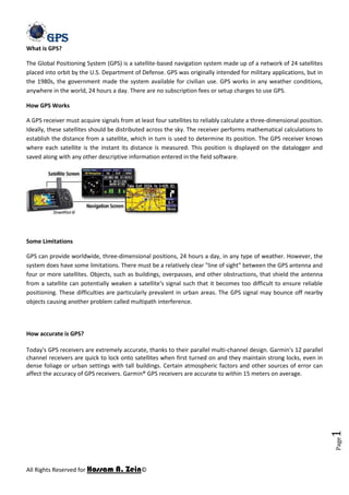
  • 1. What is GPS?<br />The Global Positioning System (GPS) is a satellite-based navigation system made up of a network of 24 satellites placed into orbit by the U.S. Department of Defense. GPS was originally intended for military applications, but in the 1980s, the government made the system available for civilian use. GPS works in any weather conditions, anywhere in the world, 24 hours a day. There are no subscription fees or setup charges to use GPS.<br />How GPS Works<br />A GPS receiver must acquire signals from at least four satellites to reliably calculate a three-dimensional position. Ideally, these satellites should be distributed across the sky. The receiver performs mathematical calculations to establish the distance from a satellite, which in turn is used to determine its position. The GPS receiver knows where each satellite is the instant its distance is measured. This position is displayed on the datalogger and saved along with any other descriptive information entered in the field software.<br />Some Limitations<br />GPS can provide worldwide, three-dimensional positions, 24 hours a day, in any type of weather. However, the system does have some limitations. There must be a relatively clear quot; line of sightquot; between the GPS antenna and four or more satellites. Objects, such as buildings, overpasses, and other obstructions, that shield the antenna from a satellite can potentially weaken a satellite's signal such that it becomes too difficult to ensure reliable positioning. These difficulties are particularly prevalent in urban areas. The GPS signal may bounce off nearby objects causing another problem called multipath interference.<br />How accurate is GPS?<br />Today's GPS receivers are extremely accurate, thanks to their parallel multi-channel design. Garmin's 12 parallel channel receivers are quick to lock onto satellites when first turned on and they maintain strong locks, even in dense foliage or urban settings with tall buildings. Certain atmospheric factors and other sources of error can affect the accuracy of GPS receivers. Garmin® GPS receivers are accurate to within 15 meters on average. <br />Newer Garmin GPS receivers with WAAS (Wide Area Augmentation System) capability can improve accuracy to less than three meters on average. No additional equipment or fees are required to take advantage of WAAS. Users can also get better accuracy with Differential GPS (DGPS), which corrects GPS signals to within an average of three to five meters. The U.S. Coast Guard operates the most common DGPS correction service. This system consists of a network of towers that receive GPS signals and transmit a corrected signal by beacon transmitters. In order to get the corrected signal, users must have a differential beacon receiver and beacon antenna in addition to their GPS. <br />The GPS satellite system<br />The 24 satellites that make up the GPS space segment are orbiting the earth about 12,000 miles above us. They are constantly moving, making two complete orbits in less than 24 hours. These satellites are travelling at speeds of roughly 7,000 miles an hour.<br />GPS satellites are powered by solar energy. They have backup batteries onboard to keep them running in the event of a solar eclipse, when there's no solar power. Small rocket boosters on each satellite keep them flying in the correct path.<br />Here are some other interesting facts about the GPS satellites (also called NAVSTAR, the official U.S. Department of Defense name for GPS):<br />The first GPS satellite was launched in 1978.<br />A full constellation of 24 satellites was achieved in 1994.<br />Each satellite is built to last about 10 years. Replacements are constantly being built and launched into orbit.<br />A GPS satellite weighs approximately 2,000 pounds and is about 17 feet across with the solar panels extended.<br />Transmitter power is only 50 watts or less.<br />What's the signal?<br />GPS satellites transmit two low power radio signals, designated L1 and L2. Civilian GPS uses the L1 frequency of 1575.42 MHz in the UHF band. The signals travel by line of sight, meaning they will pass through clouds, glass and plastic but will not go through most solid objects such as buildings and mountains.<br />A GPS signal contains three different bits of information - a pseudorandom code, ephemeris data and almanac data. The pseudorandom code is simply an I.D. code that identifies which satellite is transmitting information. You can view this number on your Garmin GPS unit's satellite page, as it identifies which satellites it's receiving. <br />Ephemeris data, which is constantly transmitted by each satellite, contains important information about the status of the satellite (healthy or unhealthy), current date and time. This part of the signal is essential for determining a position.<br />The almanac data tells the GPS receiver where each GPS satellite should be at any time throughout the day. Each satellite transmits almanac data showing the orbital information for that satellite and for every other satellite in the system.<br />Sources of GPS signal errors<br />Factors that can degrade the GPS signal and thus affect accuracy include the following:<br />Ionosphere and troposphere delays - The satellite signal slows as it passes through the atmosphere. The GPS system uses a built-in model that calculates an average amount of delay to partially correct for this type of error.<br />Signal multipath - This occurs when the GPS signal is reflected off objects such as tall buildings or large rock surfaces before it reaches the receiver. This increases the travel time of the signal, thereby causing errors.<br />Receiver clock errors - A receiver's built-in clock is not as accurate as the atomic clocks onboard the GPS satellites. Therefore, it may have very slight timing errors.<br />Orbital errors - Also known as ephemeris errors, these are inaccuracies of the satellite's reported location.<br />Number of satellites visible - The more satellites a GPS receiver can quot; see,quot; the better the accuracy. Buildings, terrain, electronic interference, or sometimes even dense foliage can block signal reception, causing position errors or possibly no position reading at all. GPS units typically will not work indoors, underwater or underground.<br />Satellite geometry/shading - This refers to the relative position of the satellites at any given time. Ideal satellite geometry exists when the satellites are located at wide angles relative to each other. Poor geometry results when the satellites are located in a line or in a tight grouping.<br />Intentional degradation of the satellite signal - Selective Availability (SA) is an intentional degradation of the signal once imposed by the U.S. Department of Defense. SA was intended to prevent military adversaries from using the highly accurate GPS signals. The government turned off SA in May 2000, which significantly improved the accuracy of civilian GPS receivers.<br />Sources of Errors in GPS<br />Selective Availability<br />The most relevant factor for the inaccuracy of the GPS system is no longer an issue. On May 2, 2000 5:05 am (MEZ) the so-called selective availability (SA) was turned off. Selective availability is an artificial falsification of the time in the L1 signal transmitted by the satellite. For civil GPS receivers that leads to a less accurate position determination (fluctuation of about 50 m during a few minutes). Additionally the ephemeris data are transmitted with lower accuracy, meaning that the transmitted satellite positions do not comply with the actual positions. In this way an inaccuracy of the position of 50 – 150 m can be achieved for several hours. While in times of selective availability the position determination with civil receivers had an accuracy of approximately 10  m, nowadays 20 m or even less is usual. Especially the determination of heights has improved considerably from the deactivation of SA (having been more or less useless before). <br />The reasons for SA were safety concerns. For example terrorists should not be provided with the possibility of locating important buildings with homemade remote control weapons. Paradoxically, during the first gulf war in 1990, SA had to be deactivated partially, as not enough military receivers were available for the American troops. 10000 civil receivers were acquired (Magellan and Trimble instruments), making a very precise orientation possible in a desert with no landmarks. <br />Meanwhile SA is permanently deactivated due to the broad distribution and world wide use of the GPS system.<br />The following two graphs show the improvement of position determination after deactivation of SA. The edge length of the diagrams is 200 m, the data were collected on May 1, 2000 and May 3, 2000 over a period of 24 h each. While with SA 95 % of all points are located within a radius of 45 m, without SA 95 % of all points are within a radius of 6.3 m.<br />Plot of the position determination with and without SA (Diagram from http://www.igeb.gov/sa/diagram.shtml (page no longer available) With friendly permission of Dr. Milbert (NOAA)) <br /> <br />quot; Satellite geometryquot; <br />Another factor influencing the accuracy of the position determination is the quot; satellite geometryquot; . Simplified, satellite geometry describes the position of the satellites to each other from the view of the receiver. <br />If a receiver sees 4 satellites and all are arranged for example in the north-west, this leads to a “bad” geometry. In the worst case, no position determination is possible at all, when all distance determinations point to the same direction. Even if a position is determined, the error of the positions may be up to 100 – 150 m. If, on the other hand, the 4 satellites are well distributed over the whole firmament the determined position will be much more accurate. Let’s assume the satellites are positioned in the north, east, south and west in 90° steps. Distances can then be measured in four different directions, reflecting a „good“ satellite geometry. <br />The following graph shows this for the two-dimensional case.<br />Good geometrical alignment of two satellites <br />If the two satellites are in an advantageous position, from the view of the receiver they can be seen in an angle of approximately 90° to each other. The signal runtime can not be determined absolutely precise as explained earlier. The possible positions are therefore marked by the grey circles. The point of intersection A of the two circles is a rather small, more or less quadratic field (blue), the determined position will be rather accurate.<br />Bad geometrical alignment of two satellites <br />If the satellites are more or less positioned in one line from the view of the receiver, the plane of intersection of possible positions is considerably larger and elongated- The determination of the position is less accurate. <br />The satellite geometry is also relevant when the receiver is used in vehicles or close to high buildings. If some of the signals are blocked off, the remaining satellites determine the quality of the position determination and if a position fix is possible at all. This can be observed in buildings close to the windows. If a position determination is possible, mostly it is not very accurate. The larger the obscured part of the sky, the more difficult the position determination gets. <br />Most GPS receivers do not only indicate the number of received satellites, but also their position on the firmament. This enables the user to judge, if a relevant satellite is obscured by an obstacle and if changing the position for a couple of meters might improve the accuracy. Many instruments provide a statement of the accuracy of the measured values, mostly based on a combination of different factors (which manufacturer do not willingly reveal).<br />To indicate the quality of the satellite geometry, the DOP values (dilution of precision) are commonly used. Based on which factors are used for the calculation of the DOP values, different variants are distinguished: <br />GDOP (Geometric Dilution Of Precision); Overall-accuracy; 3D-coordinates and time <br />PDOP (Positional Dilution Of Precision) ; Position accuracy; 3D-coordinates <br />HDOP (Horizontal Dilution Of Precision); horizontal accuracy; 2D-coordinates <br />VDOP (Vertical Dilution Of Precision); vertical accuracy; height <br />TDOP (Time Dilution Of Precision); time accuracy; time <br />HDOP-values below 4 are good, above 8 bad. HDOP values become worse if the received satellites are high on the firmament. VDOP values on the other hand become worse the closer the satellites are to the horizon and PDOP values are best if one satellite is positions vertically above and three are evenly distributed close to the horizon. For an accurate position determination, the GDOP value should not be smaller than 5. The PDOP, HDOP and VDOP values are part of the NMEA data sentence $GPGSA. <br />The satellite geometry does not cause inaccuracies in the position determination that can be measured in meters. In fact the DOP values amplify other inaccuracies. High DOP values just amplify other errors more than low DOP values. <br />The error in the position determination caused by the satellite geometry also depends on the latitude of the receiver. This is shown below in the two diagrams. The diagram on the left side shows the inaccuracy of the height (at the beginning of the curve with SA), recorded in Wuhan (China). Wuhan is situated on 30.5° northern latitude were ideal satellite constellation can be found at all time. The graph on the right side shows the same interval recorded by the Casey-Station in the Antarctica (66.3° southern latitude). Due to the satellite constellation from time to time the error is much larger. Additionally the falsification by the atmospheric effect gets more significant the closer the position is to the poles (for an explanation see “atmospheric effects”).<br />Error in the height determination at different latitudes<br /> <br />Satellite Orbits<br />Although the satellites are positioned in very precise orbits, slight shifts of the orbits are possible due to gravitation forces. Sun and moon have a weak influence on the orbits. The orbit data are controlled and corrected regularly and are sent to the receivers in the package of ephemeris data. Therefore the influence on the correctness of the position determination is rather low, the resulting error being not more than 2 m.<br /> <br />Multipath effect<br />Interference caused by reflection of the signals <br />The multipath effect is caused by reflection of satellite signals (radio waves) on objects. It was the same effect that caused ghost images on television when antennae on the roof were still more common instead of todays satellite dishes. <br />For GPS signals this effect mainly appears in the neighbourhood of large buildings or other elevations. The reflected signal takes more time to reach the receiver than the direct signal. The resulting error typically lies in the range of a few meters.<br /> <br />Atmospheric effects<br />Influenced propagation of radio waves through the earth's atmosphere <br />Another source of inaccuracy is the reduced speed of propagation in the troposphere and ionosphere. While radio signals travel with the velocity of light in the outer space, their propagation in the ionosphere and troposphere is slower. <br />In the ionosphere in a height of 80 – 400 km a large number of electrons and positive charged ions are formed by the ionizing force of the sun. The electrons and ions are concentrated in four conductive layers in the ionosphere (D-, E-, F1-, and F2-layer). These layers refract the electromagnetic waves from the satellites, resulting in an elongated runtime of the signals. <br />These errors are mostly corrected by the receiver by calculations. The typical variations of the velocity while passing the ionosphere for low and high frequencies are well known for standard conditions. Theses variations are taken into account for all calculations of positions. However civil receivers are not capable of correcting unforeseen runtime changes, for example by strong solar winds.<br />It is known that electromagnetic waves are slowed down inversely proportional to the square of their frequency (1/f2) while passing the ionosphere. This means that electromagnetic waves with lower frequencies are slowed down more than electromagnetic waves with higher frequencies. If the signals of higher and lower frequencies which reach a receiver are analysed with regard to their differing time of arrival, the ionospheric runtime elongation can be calculated. Military GPS receivers use the signals of both frequencies (L1 and L2) which are influenced in different ways by the ionosphere and are able to eliminate another inaccuracy by calculation. <br />The tropospheric effect is a further factor elongating the runtime of electromagnetic waves by refraction. The reasons for the refraction are different concentrations of water vapour in the troposphere, caused by different weather conditions. The error caused that way is smaller than the ionospheric error, but can not be eliminated by calculation. It can only be approximated by a general calculation model. <br />The following two graphs visualize the ionospheric error. The left data were collected with a one-frequency receiver without ionospheric correction, the right data were collected with a two-frequency receiver with ionospheric correction. Both diagrams have approximately the same scale (Left: latitude -15 m to +10 m, longitude -10 m to +20 m, Right: latitude -12 m to +8 m, longitude -10 m to +20 m). The right graph clearly shows less outliers, while the mean accuracy of the position for 95 % of the data is not considerably enhanced by the correction of the ionospheric error.<br />Position determination without and with atmospheric corrections by using the second frequency on a dual-frequency receiver<br />With the implementation of WAAS and EGNOS it s possible to set up „maps“ of the atmospheric conditions over different regions. The correction data are sent to the receivers, enhancing the accuracy considerably.<br /> <br />Clock inaccuracies and rounding errors<br />Despite the synchronization of the receiver clock with the satellite time during the position determination, the remaining inaccuracy of the time still leads to an error of about 2 m in the position determination. Rounding and calculation errors of the receiver sum up approximately to 1 m.<br /> <br />Relativistic effects<br />The following section shall not provide a comprehensive explanation of the theory of relativity. In the normal life we are quite unaware of the omnipresence of the theory of relativity. However it has an influence on many processes, among them is the proper functioning of the GPS system. This influence will be explained shortly in the following. <br />As we already learned, the time is a relevant factor in GPS navigation and must be accurate to 20 - 30 nanoseconds to ensure the necessary accuracy. Therefore the fast movement of the satellites themselves (nearly 12000 km/h) must be considered. <br />Whoever already dealt with the theory of relativity knows that time runs slower during very fast movements. For satellites moving with a speed of 3874 m/s, clocks run slower when viewed from earth. This relativistic time dilation leads to an inaccuracy of time of approximately 7,2 microseconds per day (1 microsecond = 10-6 seconds). <br />The theory of relativity also says that time moves the slower the stronger the field of gravitation is. For an observer on the earth surface the clock on board of a satellite is running faster (as the satellite in 20000 km height is exposed to a much weaker field of gravitation than the observer). And this second effect is six times stronger than the time dilation explained above. <br />Altogether, the clocks of the satellites seem to run a little faster. The shift of time to the observer on earth would be about 38 milliseconds per day and would make up for an total error of approximately 10 km per day. In order that those error do not have to be corrected constantly, the clocks of the satellites were set to 10.229999995453 Mhz instead of 10.23 Mhz but they are operated as if they had 10.23 MHz. By this trick the relativistic effects are compensated once and for all.<br />There is another relativistic effect, which is not considered for normal position determinations by GPS. It is called Sagnac-Effect and is caused by the movement of the observer on the earth surface, who also moves with a velocity of up to 500 m/s (at the equator) due to the rotation of the globe. The influence of this effect is very small and complicate to calculate as it depends on the directions of the movement. Therefore it is only considered in special cases.<br />The errors of the GPS system are summarized in the following table. The individual values are no constant values, but are subject to variances. All numbers are approximative values. <br />Ionospheric effects ± 5 metersShifts in the satellite orbits ± 2.5 meterClock errors of the satellites' clocks ± 2 meterMultipath effect ± 1 meterTropospheric effects± 0.5 meterCalculation- und rounding errors ± 1 meter<br /> <br />Altogether this sums up to an error of ± 15 meters. With the SA still activated, the error was in the range of ± 100 Meter. Corrections by systems like WAAS and EGNOS, which mainly reduce ionospheric effects, but also improve orbits and clock errors, the overall error is reduced to approximately ± 3 - 5 meters.<br />Choice of the carrier frequency<br />To transport data signals, a suitable carrier frequency is required. The choice of the carrier frequency is submitted to the following requirements:<br />Frequencies should be chosen below 2 GHz, as frequencies above 2 GHz would require beam antennae for the signal reception<br />Ionospheric delays are enormous for frequency rages below 100 MHz and above 10 GHz<br />The speed of propagation of electromagnetic waves in media like air deviates from the speed of light (in vacuum) the more, the lower the frequency is. For low frequencies the runtime is falsified.<br />he PRN-codes (explained below) require a high bandwidth for the code modulation on the carrier frequency. Therefore a range of high frequencies with the possibility of a high bandwidth has to be chosen.<br />The chosen frequency should be in a range where the signal propagation is not influenced by weather phenomena like, rain, snow or clouds.<br />Based on these considerations, the choice of two frequencies proved to be advantageous.Each GPS satellite transmits two carrier signals in the microwave range, designated as L1 and L2 (frequencies located in the L-Band between 1000 and 2000 MHz).Civil GPS receivers use the L1 frequency with 1575.42 MHz (wavelength 19.05 cm). The L1 frequency carries the navigation data as well as the SPS code (standard positioning code). The L2 frequency (1227.60 MHz, wavelength 24.45 cm) only carries the P code and is only used by receivers which are designed for PPS (precision positioning code). Mostly this can be found in military receivers.<br /> <br />Modulation of the carrier signals<br />C/A and P-Code<br />The carrier phases are modulated by three different binary codes: first there is the C/A code (coarse acquisition). This code is a 1023 “chip” long code, being transmitted with a frequency of 1.023 MHz. A “chip” is the same as a “bit”, and is described by the numbers “one” or “zero”. The name “chip” is used instead of “bit” because no information is carried by the signal. By this code the carrier signals are modulated and the bandwidth of the man frequency band is spread from 2 MHz to 20 MHz (spread spectrum). Thus the interference liability is reduced.The C/A code is a pseudo random code (PRN) which looks like a random code but is clearly defined for each satellite. It is repeated every 1023 bits or every millisecond. Therefore each second 1023000 chips are generated. Taking into account the speed of light the length of one chip can be calculated to be 300 m.<br /> <br />Pseudo Random Numbers (PRNs)<br />The satellites are identified by the receiver by means of PRN-numbers. Real GPS satellites are numbered from 1 – 32. To WAAS/EGNOS satellites and other pseudolites higher numbers are assigned. These PRN-numbers of the satellites appear on the satellite view screens of many GPS receivers. For simplification of the satellite network 32 different PRN-numbers are available, although only 24 satellites were necessary and planned in the beginning. For a couple of years, now more than 24 satellites are active, which optimizes the availability, reliability and accuracy of the network.<br />The mentioned PRN-codes are only pseudo random. If the codes were actually random, 21023 possibilities would exist. Of these many codes only few are suitable for the auto correlation or cross correlation which is necessary for the measurment of the signal propagation time. The 37 suitable codes are referred to as GOLD-codes (names after a mathematician). For these GOLD-codes the correlation among each other is particularly weak, making an unequivocal identification possible.<br />The C/A code is the base for all civil GPS receivers. The P code (p = precise) modulates the L1 as well as the L2 carrier frequency and is a very long 10.23 MHz pseudo random code. The code would be 266 days long, but only 7 days are used.For protection against interfering signals transmitted by an possible enemy, the P-code can be transmitted encrypted. During this anti-spoofing (AS) mode the P-code is encrypted in a Y-code. The encrypted code needs a special AS-module for each receiving channel and is only accessible for authorized personnel in possession of a special key. The P- and Y-code are the base for the precise (military) position determination. Since January 31, 1994 the AS-system is operating continiously and the P-code is only transmitted as Y-code.<br /> <br />Transmission of data<br />In the GPS system data are modulated onto the carrier signal by means of phase modulations. Phase modulation is a rarely used technique, compared to amplitude modulation (AM) or frequency modulation. In the following, these three modulation techniques shall be explained shortly.<br /> <br />Amplitude modulation<br />Amplitude modulation of a data signal onto a carrier signal <br />For the amplitude modulation the amplitude, which corresponds to the strength of the signal, is changed in accordance to the data signal that shall be transported. If this principle would be applied to sound waves, the sound level would change in order to transport a signal. With increasing attenuation it becomes more and more difficult to filter the data from the signal. This kind of modulation is known from AM radio (that's what AM stands for: amplitude modulation).<br /> <br />Frequency modulation<br />Frequency modulation of a data signal onto a carrier <br />For the frequency modulation, the carrier frequency itself is changed by modulating the data signal onto it. If we stay with the example of the sound waves, the pitch of the tones would be changed while the volume would be kept constant. Frequency modulated signals are less susceptible for disturbances and provides a higher bandwidth than AM modulation. This kind of modulation is used for FM radio.<br /> Phase modulation<br />Phase modulation of a data signal onto a carrier <br />When a data signal shall be modulated onto a carrier signal by phase modulation, the sine oscillation of the carrier signal is interrupted and restarted with a phase shift of e.g. 180°. This phase shift can be recognized by a suitable receiver and the data can be restored. Phase modulation leads to an extension of the frequency range of the carrier signal (leading to a spread spectrum) depending on how often the phase is shifted. When the phase changes, wave peaks are followed by wave minimums in a shorter distance than were in the original carrier signal (as can be seen in the graph).This kind of modulation can only be used for the transmission of digital data.<br />The following graph shows the composition of signals which are transmitted by GPS-satellites. The setup of the NAV/System data is explained in the chapter quot; data signal compositionquot; .<br />Composition of the signals from GPS satellites<br />Remark: Modulo 2 Sum means that sums are formed according to arithmetic rules. If the result is larger than 2, only the rest is kept which can not be divided by 2 (0+0=0; 0+1=1; 1+0=1; 1+1=0).<br />