3D Modeling With the ikeGPS Mobile GIS System
•Descargar como PPTX, PDF•
0 recomendaciones•763 vistas

ikeGPS not only enables you to geo-tag an image of any object, but now it also lets you create 3D models of multiple objects with just a few clicks on this mobile GIS device. TrueSize Photos captured at up to 100m distance by ikeGPS can now instantly produce highly accurate 3D models in tools such as Google SketchUp that can be fed into GIS applications such as Google Earth and ESRI. These unique features enable field crews across diverse industries to locate, identify and calculate the dimensions, area and volume of nearly any object, and document it with highly accurate real world measurements.
![Accurate Real World Measurements Two simple steps: Mark corners of flat planes ikeGPSTrueSize software creates images with real world dimensions embedded in the photo A B C E D C TrueSize Photos allow you to measure anything you see in the photo.: ,[object Object]](data:image/gif;base64,R0lGODlhAQABAIAAAAAAAP///yH5BAEAAAAALAAAAAABAAEAAAIBRAA7)
Recomendados
Más contenido relacionado
La actualidad más candente
Destacado
Último
Último (20)
3D Modeling With the ikeGPS Mobile GIS System
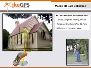
- 1. Mobile 3D Data Collection ikeTrueSize Photos Accurately Collect:- Latitude, Longitude, Heading, Altitude - Range and Orientation of the 3D Plane - All from up to 100 meters away
- 3. Width
- 4. Area1.61 M
- 5. Direct Import into Google SketchUp and Earth TrueSize Photos are automatically geo-tagged and orientated to the correct heading and location on the map