IRJET- Smart Guiding System for Blind: Obstacle Detection and Real-time Assistance via GPS
•
0 recomendaciones•35 vistas

https://irjet.net/archives/V5/i3/IRJET-V5I3109.pdf

Recomendados
Recomendados
Más contenido relacionado
La actualidad más candente
La actualidad más candente (19)
Similar a IRJET- Smart Guiding System for Blind: Obstacle Detection and Real-time Assistance via GPS
Similar a IRJET- Smart Guiding System for Blind: Obstacle Detection and Real-time Assistance via GPS (20)
Más de IRJET Journal
Más de IRJET Journal (20)
Último
Último (20)
IRJET- Smart Guiding System for Blind: Obstacle Detection and Real-time Assistance via GPS
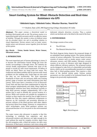
- 1. International Research Journal of Engineering and Technology (IRJET) e-ISSN: 2395-0056 Volume: 05 Issue: 03 | Mar-2018 www.irjet.net p-ISSN: 2395-0072 © 2018, IRJET | Impact Factor value: 6.171 | ISO 9001:2008 Certified Journal | Page 500 Smart Guiding System for Blind: Obstacle Detection and Real-time Assistance via GPS 1Abhishek Gupta, 2Abhishek Yadav, 3Bhaskar Sharma, 4Amrit Pal 1,2,3,4 Student, Dept. of EC, IMS Engineering College, Ghaziabad, UP, India ---------------------------------------------------------------------***--------------------------------------------------------------------- Abstract- This paper conveys a theoretical model to facilitate blind people with an aid. The primary motive is to equip blind people with necessary aid for an effective means of mobility. Through this system a sense of artificial vision can be provided which can aid in providing solution to visual impairment. Various sensors such as water sensor, smoke sensor and ultrasonic sensor together form the basis of this system. Key Words: - Vision, Smoke Sensor, Water Sensor, Ultrasonic sensor. 1. INTRODUCTION The most important part of human physiology is vision. It is because the information human beings get from the nearby surroundings is through vision. The statistics by various health organizations estimate that most of the people in world are with visual impairment, 39 billion of which are blind. There are many with low vision. The traditional and oldest mobility aids for persons with visual problems are the walking cane. Guide dogs are also used but they are not trustworthy. The most important drawbacks of these aids are necessary skills and training period, range of motion and small information that they convey. There have been a invention of lot of Electronic Travel Aids and they have been implemented to help the blind navigate independently and safely. Many high-level technological solutions have been introduced recently to help blind persons navigate independently. GPS is the system that is used to identify the current location of a person. While such systems are suitable for navigation in outdoor as they require the need for line of sight access to satellite but they also require additional components to improve on the resolution and proximity detection to prevent collision of the blind persons with other objects and protect them from danger. However in comparison to other technologies, many blind guidance systems use ultrasound because of it is not prone to the environmental noise. The major reason why ultrasonic is popular is that this technology is relatively less expensive, and also ultrasound emitters and detectors are light enough to be used without the need for complex circuitry. Apart from the old navigation aids, a blind aid system can add a new dimension of Real-space assistance and vision along with dedicated obstacle detection circuitry. Thus a system which can facilitate aid to the blind is the need of the hour. 2. SYSTEM DESIGN The design consists of two units: ● The GPS Unit. ● The Obstacle Detection Unit. The block diagram below depicts the proposed design of an embedded smart guiding system. The system elements consist of various subsystems. The sensor based circuitry consists of sensors such as smoke sensor, water sensor, ultrasonic sensors, and GSM module. Vibratory circuitry consists of an array of vibrators with logic designed to obtain different vibratory patterns. The proposed system can be designed to take form of a detachable and portable device, which can be unconditionally mounted on a simple shoe, belt or blind guiding system. This requires a clear vision of the desired system goals. Various system parameters are thus needed to be evaluated based on the design to be practically implementable. Fig-1: Block Diagram
- 2. International Research Journal of Engineering and Technology (IRJET) e-ISSN: 2395-0056 Volume: 05 Issue: 03 | Mar-2018 www.irjet.net p-ISSN: 2395-0072 © 2018, IRJET | Impact Factor value: 6.171 | ISO 9001:2008 Certified Journal | Page 501 Fig-2: Ultrasonic Sensor 3. THE GPS UNIT This system is comprises of GSM Module. The Micro controller is the heart of the device. It gathers the data of the current location which it is presented from the GPS system. It can make use of the data stored and can send location in form of latitude and longitude to the user. By this it can trace out the distance from the destination .The Arduino UNO microcontroller can be readily used with GSM Module. The cost efficacy of the GSM module makes it a perfect companion of the navigation system. The Global Positioning System (GPS) was an important invention in the United States of America that gives best positioning, navigation, and timing services to users on a complete worldwide basis which is available to all free of cost. For anyone with a GPS receiver, the system will provide location with time. GPS gives unambiguous location and time data for an unlimited number of people in all climates, day and night, anywhere in the world. The accurate timing provided by GPS facilitates everyday activities such as banking, mobile phone operations, and even the control of power grids. Surveyors, farmers, geologists and more others perform their work a little more precisely, economically, safely, and accurately using the free and abundant GPS signals. SIM808 module is a four Band GSM or GPRS module which is a combination of GPS technology for satellite navigation. SIM 808 is of utmost importance in this unit. It is acting like a GPS in this system. Fig-3: GSM Module 4. MICROCONTROLLER In this system we have used Arduino UNO. The reason for using it is that it is economic and uncomplicated to use. The support provided by Arduino is also excellent. Atmega 328 is the foundation of Arduino UNO board. It is manufactured by Arduino. It is composed of twenty digital input or output pins. Six pins may be used for Pulse Width Modulation outputs and another six may be used as analog inputs. A power jack is provide along with a sixteen MHz resonator, in-circuit system programming (ICSP) header, a USB connection and a reset button for resetting operation. It has all devices which are needed to support the microcontroller. To get the microcontroller initiated, a USB cable is essential. The difference of Arduino UNO from all other boards it that others do not utilize the FTDI USB- to-serial driver chip. Fig-4: Arduino UNO 5. OBSTACLE DETECTION UNIT The proposed system uses a combination of ultrasonic sensors which basically works on the principle of the ultrasonic sound generation and alert mechanism. The system is however having a dual feedback mechanism that is it has an additional vibratory feedback mechanism. This enhances the overall feedback received by the blind user who receives the outputs generated in different formats of vibration that is high, low, medium and strong vibrations. This Unit provides the overall edge to the proposed work so far. With the variety of obstacle detection devices available and GPS emerging as a commonly preferred technology in blind navigation kit, there is a need for providing overall assistance to the blind about the environmental information to make navigation more safe and secure. This unit comprises of getting the data from the environment, assembling the information and extracting the required information required by the blind user. The user gets alert from the vibrations from the unit on obstacle detection. The user then interprets these vibrations based on their location to know the location of obstacle.
- 3. International Research Journal of Engineering and Technology (IRJET) e-ISSN: 2395-0056 Volume: 05 Issue: 03 | Mar-2018 www.irjet.net p-ISSN: 2395-0072 © 2018, IRJET | Impact Factor value: 6.171 | ISO 9001:2008 Certified Journal | Page 502 6. CONCLUSION The paper proposed the design and architecture of a new concept of Smart Electronic Travel Guiding system for blind people. The benefit of the system is the fact that it can prove to be very cheap cost solution to billions of blind person worldwide. The presented interaction of various working units results in a real-time system that examines position of the user and provides dual feedback making navigation more secure and safe. 7. FUTURE SCOPE Rather than using GPS via a GSM module, GPS using IOT (Internet of Things) can be implemented. This can help in real time tracking using an android application. It can also help in guiding the blind person by giving him voice based instructions for following directions. The system can also make use of stereo camera and processing unit, to process the data. 8. REFERENCES [1] S. Ceranka, and M. Niedzwiecki, "Application of particle filtering in navigation system for blind," in Proc. ISSPA, 1-4 July2003, vol.2, pp. 495- 498 [2] S. Shoval, I. Ulrich, and J. Bornstein, "NavBelt and guideCane," IEEE Robotics and Automation Magazine, vol. 10, no 1, pp. 9-20, 2003. [3] T. I fukube, T. Sasaki, and C. Peng, "A blind mobility aid modeled after echolocation of bats," IEEE Transactions on Biomedical Engineering, vol. 38, no. 5, pp. 461-465, 1991. [4] I. Ulrich, and J. Bornstein, "The guide cane Applying mobile robot technologies to assist visually impaired," IEEE Transaction on Systems, Man, and Cybernetics- PartA. Systems and Humans, vol. 31, no. 2, pp. 131-136, 2001. [5] A. Heyse, "A polaroid ultrasonic travel aid for the blind, "Journal of Visual Impairment and Blindness, vol. 76, pp. 199-201, 1982