

Recomendados
Recomendados
Más contenido relacionado
La actualidad más candente
La actualidad más candente (12)
Similar a Climate change
Similar a Climate change (20)
Último
Último (20)
Climate change
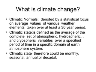
- 1. What is climate change? • Climatic Normals: denoted by a statistical focus on average values of various weather elements taken over at least a 30 year period. • Climatic state:is defined as the average of the complete set of atmospheric, hydrospheric, , and cryospheric variables over a specified period of time in a specific domain of earth atmosphere system. • Climatic state therefore could be monthly, seasonal, annual,or decadal.
- 2. What evidences suggest change?• Direct evidence: daily weather records (but limited for about past two centuries and for very selected stations. • Historical climatic data: written records and observations on crop yields and drought. (for Nile valley data for thousands of years are available). • Proxy climatic data: from natural world such as sediments deposited on the sea floor to concentric growth rings of tree trunks (dendrochronology.
- 3. Climatic History: The past 150 years• Accurate record keeping based on reliable instruments began only during the last 150 years. • Limited to western Europe and North America • Most of the other areas have records for less than 50 years. • Records of West Africa ended or interrupted during the instability of 1960s. • Satellite observations are few decades old and surface verification is inadequate. • Absence of dependable long term data is a major obstacle in understanding of climate change. • Warming trend 1880 to 1940, a cooling trend from 1940 to 1960 and again warming trend. • Regional variations: Higher latitudes are more vulnerable.
- 4. Past 1500 years • The earth was warm and becoming warmer during the centuries prior to AD 1000. Similar to what we are experiencing today. • Sea level was high. Low lying coastal countries coped with rising water (Polders were built by Dutch) • High latitudes environs of Greenland and Iceland were amenable to settlement. • The Romans planted grapevines in Britain and wine industry thrived. • Grains were grown in Iceland and Greenland.(The Little Ice Age by Jean Groves)
- 5. Past 15000 years • Conclusions based on seeds, tools, and other artifacts recovered from ancient inhabited sites. • Earth was in the grip of a major glaciation that lasted about 80 thousand years. • Major part of USA and Canada were covered by ice sheets. North Asia, Europe and all higher mountains lay under ice caps.
- 6. Climate Change:External processes • Periodic variation in the shape of the earth’s orbit around the sun. (a cycle of about 100,000 years. Elliptical to circular. • Obliqueness of the earth’s axis (41,000 years cycle). Earth rolls like a ship on its axis.(65.6 to 68.2 degrees) • Wobble effect (a cycle of 21,000 years)
- 7. Climate change : Internal process • Heat and water exchange in the atmosphere
- 9. In some 40 poor, developing countries, with a combined population of 2 billion, including 450 million undernourished people, production losses due to climate change may drastically increase the number of undernourished people, severely hindering progress in combating poverty and food insecurity," the FAO report says
- 10. India could lose 125 million tons, or 18 per cent, of its rainfed cereal production, while China’s rainfed cereal production of 350 million tons is expected to rise by 15 per cent.
- 11. Agriculture will have to adapt to an accelerating stream of new pests and diseases caused by changing ecological conditions resulting from climate change
- 12. The report warns that temperature changes, as well as increased air pollution, can intensify human disease patterns, as does the spread of trans- boundary animal diseases caused by pathogens that are potentially dangerous to humans. “Avian flu is the most recent example,”.
- 13. Climate change not only has an impact on food security, but is also likely to influence the development and intensification of animal diseases and plant pests
- 14. Sixty-five developing countries, home to more than half the developing world's total population in 1995, risk losing about 280 million tons of potential cereal production, valued at $56 billion, as a result of climate change. This loss would be equivalent to 16 per cent of the agricultural gross domestic product (GDP) of these countries in 1995 dollars. FAO
- 15. Expanding Drought Prone Areas in India
- 16. Drought ? • Meteorologist: the absence or severe deficiency of rainfall • Agronomist: the absence of soil moisture • Hydrologist: the absence of water in the storage reservoirs
- 17. Drought ? • For a farmer : It is a failure of his crop • For urban centered people like us: Rise in price of daily needed food items such as onion, potato etc or power cuts .
- 18. Drought ? • It is a serious imbalance between soil moisture and evapotranspiration needs of an area
- 19. Drought? Drought: It can occur any where in the world Drought Affected Areas: Any area affected in a season or a year. Drought Prone areas: Frequently/chronically drought affected areas.
- 20. Table 1 Production And Per Capita Availability of Food Grains in India, 1960-2003 Year Food grain Output (in miilion tonnes Net per capita output (kg/year) Net per capita availability (grams/day) Cereals Pulses Total Cereals Pulses Total 1960-63 82.0 158 29 187 400 69 469 1970-73 103.5 144 17 162 418 51 469 1980-83 130.8 149 14 163 417 38 455 1990-93 174.8 163 13 176 468 42 510 2000-03 194.3 152 10 162 391 26 417
- 21. Table 2 Drought Prone Area: Evolution of Identification Criteria S.NO. Organization/Body Year Criteria 1 Ministry of Agriculture 1967 • Total or almost total failure of crops once 3/5/10 years. 2 Committee of Secretaries 1970-71 • Incidence of Rainfall • Environmental conditions •Chronic liability to drought 3 Gidwani Committee 1971 • Irrigation of rainfall over a period of time. • Extent of irrigation area in the district • Chronic liability to drought. 4 Irrigation Commission 1972 • Irrigation on about 30 per cent of total cropped area as immunity against drought. • Probability of critical rainfall shortage by 20 per cent • An adverse water balance 5 Swaminathan Commission 1982 • Average annual rainfall below 1125 mm. • Irrigation below 40 per cent of total cropped area. 6 Inter- departmental Group and Central Sanctioning Committee 1984 1987 • Average annual rainfall below 1650 mm • Irrigation below 10 per cent of total cropped area. 7 Hanumantha Rao Committee 1994 • Moisture Index • Percentage of area under irrigation
- 22. Table 3 Drought Prone Area Programme: An Overview of Coverage 1 2 3 4 5 6 Commission/ Committees/ Task Force Year States District Block Remark Secretaries Committee and Ministry of Agriculture 1970-71 8 23 - Districts as identification unit. Gidwani Committee 1971 13 54 - In addition, contiguous areas in another 18 districts were identified Irrigation Commission 1972 8 68 321 Identification unit changed to Talukas B.S.Minhas Task Force 1973 13 74 557 Identification unit changed to Block Swaminathan Committee 1982 13 69 511 -do- Inter Departmental Council/ Central Sanctioning Authority 1984-87 13 92 615 -do- Hanumantha Rao 1994 13 183 972 -do-
- 23. Table 4 Drought Prone Area Programme: State Level Coverage, 1996 S.No. State Total Districts DPAP Districts DPAP Districts as per cent to Total Districts Total Blocks DPAP Blocks DPAP Blocks as per cent to Total Blocks 1 Andhra Pradesh 23 11 47.80 1092 94 8.6 2 Bihar 42 12 28.57 591 121 20.5 3 Gujarat 19 10 52.60 184 52 28.3 4 Himachal Pradesh 12 3 25.00 69 9 13.0 5 Jammu Kashmir 14 2 14.30 119 22 18.5 6 Karnataka 20 11 55.00 175 81 46.3 7 Madhya Pradesh 45 25 55.60 459 134 29.2 8 Maharashtra 30 22 73.30 298 148 49.7 9 Orissa 13 5 38.46 314 47 15.0 10 Rajasthan 27 9 33.33 213 32 15.0 11 Tamil Nadu 21 12 57.14 385 80 20.8 12 Uttar Pradesh 63 17 26.98 897 91 10.1 13 West Bengal 17 4 23.50 339 36 10.6 Total (DPAP States) 346 143 41.32 5135 947 18.4 India 466 143 30.68 5767 947 16.4
- 24. Table 5 Drought Prone Area Programme: Criteria for Financial Allocation Period Criteria Funding Arrangements Allocation Method Remarks 1974-79 Area of the District covered under the programme in percentage Shared equally between the centre and concerned states Districts with coverage of 1 > 75 per cent: Rs60 million for five year plan period 2 50-75 per cent: Rs50 million for five year plan period 3 < per cent: Rs40 million for five year plan period 1979-87 Number of Blocks covered in a district Shared equally between the centre and concerned states Rs 1.5 million per block per annum In 1983: Rs 12 million per block per annum 1988-95 Area of Block covered in a district Equally shared between the centre and concerned states Block with an area of I > 1000 sq.km. : Rs.1.85 million per block per annum. II >500- 1000 sq.km. : Rs.1.65 million per block per annum III > 500 sq.km. : Rs.1.5 million per block per annum 1995- till date Area of blocks and number of watershed projects running Equally shared between the centre and concerned states Rs 500 thousand /375 thousand per project in semi arid/ Dry sub humid for a maximum of 3,5 and 6 projects in a block of 400 sq.km and above 800 sq.km. respectively April 1, 1999- till date Area of blocks and number of watershed projects running 75:25 between centre and state 30 lakh for a watershed project of 500 ha.
- 25. Table 6 Drought Prone Area Programme : Changes in Administrative Coverage by States, 1970-71 to 1996 Sr. No 1 2 3 4 5 6 7 8 States Years 1070-71 1971 1972 1973 1982 1984-87 1996 1 Andhra Pradesh 4 5 7 (56) 7 (76) 7 (66) 8 (69) 11 (94) 2 Bihar - 3 4 (57) 2(31) 5 (54) 16 (121) 3 Gujarat 7 7 11 (58) 10 (41) 8 (42) 8 (43) 10 (52) 4 Haryana 1 1 4 (6) 3 (31) 1 (09) 1 (9) - 5 Himachal Pradesh - - - - - - 3 (9) 6 Jammu & Kashmir - 1 - 2 (13) 2 (13) 2 (13) 2 (22) 7 Karnataka 2- 5 12 (88) 10 (46) 10 (70) 11(71) 11 (81) 8 Madhya Pradesh - 4 9 (23) 6 (42) 6 (48) 6 (49) 25 (134) 9 Maharashtra 2 6 9 (45) 6 (42) 9 (53) 12 (74) 22 (148) 10 Orissa - 2 - 2 (25) 4 (39) 4 (39) 8 (47) 11 Rajasthan 5- 10 9 (19) 13 (79) 4 (18) 8 (30) 10 (32) 12 Tamil Nadu - 2 7 (24) 2 (48) 3 (30) 7 (43) 15 (80) 13 Uttar Pradesh 1 6 - 6 (40) 10 (63) 17 (87) 18 (91) 14 West Bengal - 2 - 3 (35) 3 (29) 3 (34) 4 (36) India 23 54 68 (321) 68 (321) 69 (511) 92 (615) 155 (947)
- 26. Table 7 Drought Prone Area Programme: Areal Coverage by States S. No. States Total Area DPAP Area DPAP Area as per cent to Total Area of the State DPAP Area as per cent to Total DPAP Area of India 1 Andhra Pradesh 275045 99876 36.31 13.38 2 Bihar 173877 44394 25.53 5.95 3 Gujarat 196024 43938 22.41 5.89 4 Himachal Pradesh 55673 3327 5.98 0.45 5 Jammu & Kashmir 222236 14740 6.63 1.98 6 Karnataka 191791 84332 43.97 11.30 7 Madhya Pradesh 443446 110863 25.00 14.86 8 Maharashtra 307690 194273 63.14 26.04 9 Orissa 155707 26168 16.81 3.51 10 Rajasthan 342239 31769 9.28 4.26 11 Tamil Nadu 130058 29426 22.63 3.94 12 Uttar Pradesh 294411 51494 17.49 6.90 13 West Bengal 88752 11594 13.06 1.55 Total (DPAP States) 2876949 746194 25.94 100.00 India 3287263 746194 22.70 100.00
- 30. Some Conclusions • Climate change is inevitable. It changed in the past, it is changing in the present and shall change in the future. • Any rapid change is disastrous for human survival. • Human intervention is on the rise and must be minimised. • Limited climatic data is inadequate for precise synthesis.
- 31. Some Conclusions • Drought prone areas cover 36 per cent of the total land area. It was only 19 per cent in 1973. (DPA-22.7 %, Desert –13.4%). • Drought prone were identified in Himachal Pradesh. • Drought Prone areas of Haryana have been put under desert. • Hot non sandy deserts were identified in Andhra Pradesh and Karnataka.
- 32. Some Conclusions • There is a need for drought resistant crops for the drought prone areas and water resistant in the flood prone areas.However seeds must be resistant to pests and insects in all the areas.