Tanzania mapping groups Morogoro flooding Erick.pdf
•
1 recomendación•131 vistas

Presentation about Youthmapper project on flood analysis in Morogoro, Tanzania.

Recomendados
Recomendados
Más contenido relacionado
La actualidad más candente
La actualidad más candente (9)
Similar a Tanzania mapping groups Morogoro flooding Erick.pdf
Similar a Tanzania mapping groups Morogoro flooding Erick.pdf (20)
Más de Janet Chapman
Más de Janet Chapman (20)
Último
Último (20)
Tanzania mapping groups Morogoro flooding Erick.pdf
- 2. SHORT BIO Erick Tamba Mnyali Bsc. Environmental sciences and management (SUA)| GIS Specialist| Researcher| YouthMappers Regional Ambassador 2021/2022 Career interest Geospatial technology for sustainable development
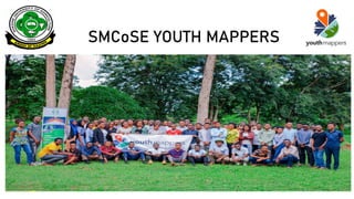
- 3. SMCOSE YOUTHMAPPERS FIELD PROJECT PROGRAM TITLE: Flood vulnerability mapping Location: Morogoro urban, Tanzania (February- July, 2021) Powered by youthmappers 1
- 4. Challenge Local communities vulnerable to floods experience both primary and secondary effects such as death and spread of diseases. with lack of enough data for disaster management stakeholders, Preparedness, Response, Recovery, Planning and Mitigation is still a challenge during floods.
- 6. OBJECTIVES Identify The Flood Vulnerable Areas Within Morogoro Urban Collecting Trash Point, Dumps and Trash Collection Techniques Datasets In All Flood Vulnerable Areas In Morogoro Urban
- 8. WHERE?
- 9. DATA A) TRASH POINTS (Geo-points, type, accessibility, and status of waste) B) HOUSEHOLDS SURVEY
- 10. RESULTS
- 13. EFFECT TO BE MITIGATED SPREAD OF DISEASES (e.g cholera) HOW? Mapping the best waste collection route in Mazimbu, Tanzania WORKSHOP
- 19. …
- 20. CURRENT PROJECT
- 21. PRESENTATION TEMPLATE Tea Ceremony Global Integrated Flood and Drought Management Competition for #Youth-led Projects
- 22. Presented challenge In developing countries, Lack of effective disaster response capabilities to floods events is linked to outdated maps and insufficient data that address risks and vulnerability challenges in local communities. In this context people at risk, rescue teams as well as other stakeholders have little or no understanding on evacuation routes and safe areas before and during flood events
- 23. STUDY AREA
- 24. Mazimbu ward in Morogoro Municipality Video by Innocent, SMCOSE YouthMappers November 2021
- 26. RIVER LUMEMO RESIDENTIAL AREAS Ifakara Town Council, Tanzania
- 27. PROPOSED PROJECT TITLE MAPPING FLOOD PROTECTION ZONES AND EVACUATION ROUTES TO IMPROVE RESPONSE CAPABILITIES (EWS) A case study of Two Vulnerable communities in Morogoro region, Tanzania (Ifakara Town Council and Morogoro municipality)
- 28. MILESTONES/OBJECTIVES 1. Community data gathering ▪ Remote mapping ▪ Field data collection OpenDataKit (ODK) Humanitarian OpenStreetMap Tasking manager
- 31. 2. Flood protection zones and evacuation routes mapping using GIS techniques ▪ Flood risk mapping using remote sensing data such as digital elevation model as well as field data collected to identify flood protection zones and mapping the evacuation routes Terrain analysis Network analysis
- 32. 3. Project findings dissemination ▪ Workshop and Trainings to stakeholders (local government rescue teams, institutions and NGOs) ▪ Data sharing and access OpenStreetMap Climate Risk Database
- 33. TIMELINE Concept Note Pitch deck Milestone 1 Work shops and data Sharing Data Analysis and map layouts (web and base maps) Kick start and partnerships Community Data gathering Defining flood secondary challenges and Partnerships Milestone 2 Milestone 3 Project extension JANUARY-MARCH 2022 1 Month 1 Month 2 Month ---------- 2 Month
- 34. Synergies of proposed project This project proposed shall help produce data that will help effectively train the machine learning model (ongoing project) for predicting flash floods in Morogoro municipal.
- 35. ACCOMPLISHMENT
- 38. WHAT NEXT FIELD DATA COLLECTION
- 40. LESSON LEARNT Open source geospatial tools have proved to be reliable and effective in collection of Community based data to address solutions and challenges in our local communities
- 42. THANK YOU FOR YOUR ATTENTION