Photos set 1-1 mgb
•
0 recomendaciones•425 vistas

Photos from Brgys Humayhumay, Calamba, Bulado, Tacpao

Recomendados
Más contenido relacionado
Destacado
Más de Jessica Villarmente
Más de Jessica Villarmente (20)
Último
Último (20)
Photos set 1-1 mgb
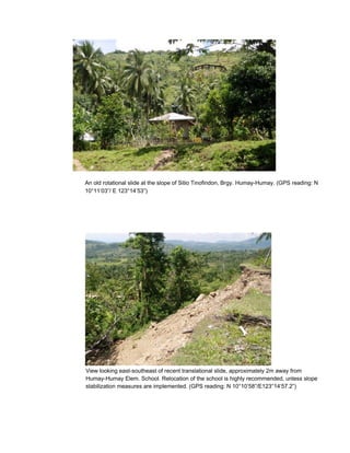
- 1. An old rotational slide at the slope of Sitio Tinofindon, Brgy. Humay-Humay. (GPS reading: N 10°11’03”/ E 123°14’53”) View looking east-southeast of recent translational slide, approximately 2m away from Humay-Humay Elem. School. Relocation of the school is highly recommended, unless slope stabilization measures are implemented. (GPS reading: N 10°10’58”/E123°14’57.2”)
- 2. Tension cracks (arrows) on classrooms and basketball court at Humay-Humay Elem. School. (GPS reading: N 10°10’58”/E123°14’57.2”)
- 3. View looking east of tension cracks along the barangay road of Brgy. Humay-Humay. (GPS reading: N10°11’02.8”/E123°15’03.5”) A translational slide at the southern portion of the area shown in the previous photo. Note the boulder-sized debris on the mid-slope of slide. (GPS reading: N10°11’02.8”/E123°15’03.5”)
- 4. View looking west of tension cracks on top of the mountainous portion of Brgy. Humay- Humay. Houses at the top of the slope are at high risk to landslide.(GPS reading: N10°11’10.3”/E123°14’54.6”) Drainage Canal View looking east of an unstable slope as evidenced by damaged drainage canal along the barangay road leading to Humay-Humay Elementary School.(GPS reading: N10°10’53”/E123°14’58.6”)
- 5. An unstable slope as indicated by tension cracks and terracetes at Brgy. Calamba, viewed from Brgy. Humay-Humay. (GPS reading: N10°10’41.2”/E123°15’18”) View looking north of a huge rotational slide (upper portion) and widespread terracettes (middle portion) at Sitio Kinamoan, Brgy. Calamba. (GPS reading: N10°10’32.7”/E123°15’45.1”)
- 6. View looking south of a rockfall at Sitio Maantol, Brgy. Calamba. Note the huge boulder that is precariously hanging. (GPS reading: N10°10’16.7”/E123°16’13.7”) View looking southeast of barangay road at Brgy. Calamba that is of high risk to landslide/rockfall (previous photo). (GPS reading: N10°10’16.7”/E123°16’13.7”)
- 7. View looking northeast of a huge translational slide near an intersection (national and barangay roads) at Brgy. Calamba. Houses located at the footslope are at high risk to landslide. (GPS reading: N10°10’50.8”/E123°16’53.4”) One of the many huge rotational slides on steep slopes bounding Sitio Pilaon, Brgy. Calamba. These slides could cause artificial damming that would eventually lead to flashflood. (GPS reading: N10°11’22.9”/E123°16’14.1”)
- 8. View looking south of a barangay road at Sitio Pilaon, Brgy. Calamba that is of high risk to landslide. (GPS reading: N10°11’22.9”/E123°16’14.1”) A recent landslide along National Road at Brgy. Calamba Proper. (GPS reading: N10°10’57.9”/E123°17’03.4”)
- 9. View looking west of another recent landslide near the boundary of Brgys. Calamba and Bolado. (GPS reading: N10°10’59.9”/E123°17’03.4”)
- 10. View looking west of a rockfall affecting a steep slope bounding the National Road at Brgy. Calamba Proper. Se highly discouraged. (GPS reading: N10°10’57.2”/E123°17’03.4”) Panoramic view of a rolling terrain at Brgy. Malusay, as viewed from Brgy. Humay-Humay. (GPS reading: N1
- 11. Slope at Brgy. Bolado that is underlain by moderately weathered and jointed, interbedded mudstone and sandstone. A widespread creep as indicated by terracettes affecting Sitio Maculos, Brgy. Bolado. (GPS reading: N10°11’58”/E123°16’23.3”)
- 12. Panoramic view of Lag-asan Elementary School. This school is located on top of flat to rolling terrai N10°13’14.5”/E123°14’18.4”) Panoramic view of a huge complex slide at Sitio Lag-asan, Brgy. Tacpao. Settlement at the foot of the slope is hig stabilization measures are implemented. (GPS reading: N10°12’59.9”/E123°13’53.9”)
- 13. View looking east of numerous translational slides at Sitio Macaang-cog, Brgy. Tacpao, sighted from Sitio Lag-asan, Brgy. Tacpao. (GPS reading: N10°12’58.1”/E123°13’55.5”) View looking southeast of another translational slides at Sitio Macaang-cog, Brgy. Tacpao, also sighted from Sitio Lag-asan, Brgy. Tacpao. (GPS reading: N10°12’58.1”/E123°13’55.5”)
- 14. A recent complex landslide at Sitio Kambang, Brgy. Tacpao. (GPS reading: N10°12’44.2”/E123°16’13.3”) A slope at Brgy. Tacpao moderately to highly weathered bedded limestone. This slope limestone is highly susceptible to rockfall. (GPS reading: N10°12’44.2”/E123°16’13.3”)
- 15. View looking northeast of flat to rolling terrain of Macalua Farm near the boundary of Brgys. Binobohan and Tacpao (Sitio Naluod). Note the rotational slide (arrow) located at the edge of the hill. (GPS reading: N10°13’31.0”/E123°16’17.0”)