Qgis OpenlayersPlugin
•
2 likes•2,862 views

This tutorial sets out the easy steps to displaying aerial photography and data from the most well known mapping applications on the web in your QGIS project. Please note that each of the data providers have a set of terms and conditions for the use of their data, please refer to these terms and conditions before using or publishing the data. N. Alexander - ERGO

Recommended
Recommended
More Related Content
Similar to Qgis OpenlayersPlugin
Similar to Qgis OpenlayersPlugin (20)
More from Universidad Regional Amazónica Ikiam / Universidad de Carabobo
More from Universidad Regional Amazónica Ikiam / Universidad de Carabobo (20)
Recently uploaded
Recently uploaded (20)
Qgis OpenlayersPlugin
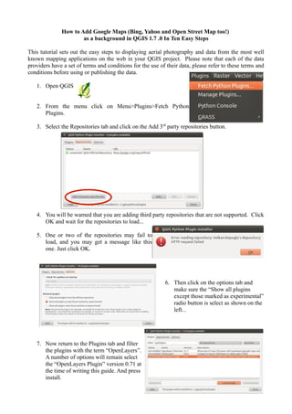
- 1. How to Add Google Maps (Bing, Yahoo and Open Street Map too!) as a background in QGIS 1.7 .0 In Ten Easy Steps This tutorial sets out the easy steps to displaying aerial photography and data from the most well known mapping applications on the web in your QGIS project. Please note that each of the data providers have a set of terms and conditions for the use of their data, please refer to these terms and conditions before using or publishing the data. 1. Open QGIS 2. From the menu click on Menu>Plugins>Fetch Python Plugins. 3. Select the Repositories tab and click on the Add 3rd party repositories button. 4. You will be warned that you are adding third party repositories that are not supported. Click OK and wait for the repositories to load... 5. One or two of the repositories may fail to load, and you may get a message like this one. Just click OK. 6. Then click on the options tab and make sure the “Show all plugins except those marked as experimental” radio button is select as shown on the left... 7. Now return to the Plugins tab and filter the plugins with the term “OpenLayers”. A number of options will remain select the “OpenLayers Plugin” version 0.71 at the time of writing this guide. And press install.
- 2. 8. If the Openlayers Plugin installs successfully yo will get a confirmation message. “plugin installed successfully”. Press OK and close the Plugin Installer window. 9. Now before checking that the plugin is working it is advised to either open an existing QGIS project or add some data to an empty project. This is because the OpenLayers Plugin needs an extent to be defined before it can add any data. 10. So once you have some data in QGIS add a layer from your newly installed plugin via the dropdown menu Plugins>OpenLayers Plugin>Add Google Satellite layer (for instance). Congratulations you have completed the Tutorial! This tutorial was written by Neil Alexander from The Environmental Research group Oxford for the EDENext FP7 Research Project and was originally posted on www.edenextdata.com.