SlideShare una empresa de Scribd logo
1 de 31
Remote sensing what is it?

• Observation from a distance
– Aerial photographs- very detailed
– Satellite images – global view
Oblique aerial photograph

• Viewed from an oblique angle: looking
sideways
• Looks natural, easy to understand,
useless for measurement purposes
Vertical aerial photograph

• Viewed straight down giving a “map view”
• Difficult to understand at first. Can be used
as a basis of mapping, after image has
been rectified
Aerial photographs: 1995 and 1972
Map derived form aerial photographs

• Visible features are “digitised” by tracing
around them on a computer screen.
• This creates the points lines and polygon
symbols which build up into the map
Stereo-photography 3-d visualisation

• Overlapping aerial photographs can be used to build
3-d stereoscopic visual models. These can be used
to map out contours and heights of features

Photo 1

Photo 2
Plane travels at
constant
altitude above
sea level.
Height above
ground varies
with
topography

overlap
60% of image
Stereoscopic reconstruction of overlapping areas

• A stereoscope is used to view the overlapping areas
simultaneously and the brain builds a 3-d model of
the landscape where the images overlap.
Left eye

Right eye

Photo 1

Photo 2

overlap
Digital manipulation of aerial photographs

• 3-d models can also be built by “digitally draping”
photographs over a digital elevation model of the
landscape.
Satellite Remote Sensing

• Satellites give a higher viewpoint and give
unrestricted coverage of the whole globe

Link to Gateway Remote sensing video
http://gateway.rac.ac.uk/mod/resource/view.php?id=3937
Satellite orbits

• Geostationary orbit: above the equator,
35,000 km height, orbital period 24
hours. Satellites appear fixed in sky
• Low Earth orbit, usually polar, orbital
period can be less than 1 hour.
Satellites seen to move across sky
Geo-stationary meteorological satellite: Meteosat

• Geostationary orbits, approx 33,000 km elevation
over the equator. Satellite takes 24hours for one
orbit, the earth rotates once in that time, so the
satellite appears stationary in the sky
Infra-red image from 0600
March 8, 2000

“Ground” position
of satellite
Polar orbiting meteorological satellites

• Polar orbiting satellites cover the whole globe, but
move, so there are long time intervals between one
image and the satellites next return
Earth observation satellites: Landsat 7 image (30m resolution)

• Earth observation satellites are designed to view the
surface of the globe. Some are designed for view the
oceans, others, like the Landsat series, observe the
land
2004 tsunami: Aceh province, Sumatra
Land classification; spectral signatures: Using SPOT images

• Simultaneous Multi-spectral images can be used to
classify landcover.
• The reflectance of certain landcover types are measured
on each image to build up a signature of that type of
cover. This is then searched for over the whole image
Land classification; spectral signatures: Using SPOT images

• Simultaneous Multi-spectral images can be used to
classify landcover.
• The reflectance of certain landcover types are measured
on each image to build up a signature of that type of
cover. This is then searched for over the whole image
Land classification; spectral signatures: Using SPOT images

• Simultaneous Multi-spectral images can be used to
classify landcover.
• The reflectance of certain landcover types are measured
on each image to build up a signature of that type of
cover. This is then searched for over the whole image
Land classification; spectral signatures: Using SPOT images

• Simultaneous Multi-spectral images can be used to
classify landcover.
• The reflectance of certain landcover types are measured
on each image to build up a signature of that type of
cover. This is then searched for over the whole image
Remote
sensing
images:
Harnhill farm
Aerial photograph, 2011
Spatial resolution approx. 0.2m
GoogleMaps aerial photo,
Spatial resolution approx. 1.5m
Scanned Aerial photograph, 1995
Spatial resolution approx. 2.0m
Landsat 5 image, circa 2001
Spatial resolution approx. 30m
LIDAR image, 2011
Spatial resolution approx. 1.0m
Vertical resolution approx. 0.001m
Landsat 5: 30m resolution

• Landsat 5 image of Gloucestershire
(Landsat 6 crashed on take off. Landsat 7
is current satellite, Landsat 8 has just
been launched)
Cheltenham
Gloucester

Harnhill

Swindon
Ikonos: 1m resolution

• Commercial panchromatic image at 1m resolution.
On the original image people can be seen walking in
Horse Guards Parade and the spokes of the London
Eye are visible
Ikonos agricultural image 1m resolution

• Another Ikonos image showing the detail available in
an agricultural image, here form Montana
• How useful is this for farmers?
RADARSAT classified image of Flevoland, NL

• Radar, “active remote sensing”, sees through clouds
and in the dark. This addresses some of the major
problems with “Passive remote sensing” which
measures reflected sunlight.
• The images are very difficult to interpret
RADARSAT-Mozambique floods

• Shuttle borne radar image of the Mozambique floods
• Radar is good at detecting the edge of water bodies,
which it can “see” through cloud cover
Remote sensing summary

• Aerial photography gives us a controllable,
highly detailed view of the Earth
• Satellite imagery gives global, unrestricted
views which are repeated a frequent intervals
• The references to actions such as
“interpretation” and “classification” lead on to
things we can do with a geographic
information system (GIS) using remote
sensing as a source of data

Más contenido relacionado

La actualidad más candente

LiDAR Data Processing and Classification
LiDAR Data Processing and ClassificationLiDAR Data Processing and Classification
LiDAR Data Processing and Classification
Michal Bularz
 
Fundamentals of Remote Sensing
Fundamentals of Remote Sensing Fundamentals of Remote Sensing
Fundamentals of Remote Sensing
Pallab Jana
 

La actualidad más candente (20)

Sensors
SensorsSensors
Sensors
 
remote sensing
remote sensingremote sensing
remote sensing
 
Lidar
LidarLidar
Lidar
 
Photogrammetry-part 1
Photogrammetry-part 1Photogrammetry-part 1
Photogrammetry-part 1
 
Remote sensing and image interpretation
Remote sensing and image interpretationRemote sensing and image interpretation
Remote sensing and image interpretation
 
Spot 7 satellite
Spot 7 satelliteSpot 7 satellite
Spot 7 satellite
 
Remote Sensing
Remote Sensing Remote Sensing
Remote Sensing
 
LiDAR Data Processing and Classification
LiDAR Data Processing and ClassificationLiDAR Data Processing and Classification
LiDAR Data Processing and Classification
 
Thermal remote sensing
Thermal remote sensingThermal remote sensing
Thermal remote sensing
 
Remote sensing - Sensors, Platforms and Satellite orbits
Remote sensing - Sensors, Platforms and Satellite orbitsRemote sensing - Sensors, Platforms and Satellite orbits
Remote sensing - Sensors, Platforms and Satellite orbits
 
Introduction to LiDAR presentation.
Introduction to LiDAR presentation.Introduction to LiDAR presentation.
Introduction to LiDAR presentation.
 
.remote sensing.Ece 402 unit-2
.remote sensing.Ece 402 unit-2.remote sensing.Ece 402 unit-2
.remote sensing.Ece 402 unit-2
 
Thermal remote sensing
Thermal remote sensing   Thermal remote sensing
Thermal remote sensing
 
Ikonos
IkonosIkonos
Ikonos
 
Gis (geographic information system)
Gis (geographic information system)Gis (geographic information system)
Gis (geographic information system)
 
Drone flight data processing
Drone flight data processingDrone flight data processing
Drone flight data processing
 
Photogrammetry
PhotogrammetryPhotogrammetry
Photogrammetry
 
Remote Sensing Imagery & Artificial Intelligence
Remote Sensing Imagery & Artificial IntelligenceRemote Sensing Imagery & Artificial Intelligence
Remote Sensing Imagery & Artificial Intelligence
 
Fundamentals of Remote Sensing
Fundamentals of Remote Sensing Fundamentals of Remote Sensing
Fundamentals of Remote Sensing
 
Remote Sensing ppt
Remote Sensing pptRemote Sensing ppt
Remote Sensing ppt
 

Similar a Remote sensing

Satellite and aerial surveys
Satellite and aerial surveysSatellite and aerial surveys
Satellite and aerial surveys
Julian Swindell
 
mateorological and ocean monitoring satellite (2).pptx
mateorological and ocean monitoring satellite (2).pptxmateorological and ocean monitoring satellite (2).pptx
mateorological and ocean monitoring satellite (2).pptx
sapna kinattinkara
 
Geometry and Projection of Aerial Photograph
Geometry and Projection of Aerial PhotographGeometry and Projection of Aerial Photograph
Geometry and Projection of Aerial Photograph
ShavnamMehta
 

Similar a Remote sensing (20)

Satellite and aerial surveys
Satellite and aerial surveysSatellite and aerial surveys
Satellite and aerial surveys
 
REMOTE SENSING_TOPIC_II_2023.pptx
REMOTE SENSING_TOPIC_II_2023.pptxREMOTE SENSING_TOPIC_II_2023.pptx
REMOTE SENSING_TOPIC_II_2023.pptx
 
Satellite science
Satellite scienceSatellite science
Satellite science
 
mateorological and ocean monitoring satellite (2).pptx
mateorological and ocean monitoring satellite (2).pptxmateorological and ocean monitoring satellite (2).pptx
mateorological and ocean monitoring satellite (2).pptx
 
Aerial Photography.pptx
Aerial Photography.pptxAerial Photography.pptx
Aerial Photography.pptx
 
Unit 1-stallite orbit (1)
Unit 1-stallite orbit (1)Unit 1-stallite orbit (1)
Unit 1-stallite orbit (1)
 
PHOTOGRAMMETIC SURVEYING
PHOTOGRAMMETIC SURVEYING PHOTOGRAMMETIC SURVEYING
PHOTOGRAMMETIC SURVEYING
 
Remote Sensing platforms and types of RS.pptx
Remote Sensing platforms and types of RS.pptxRemote Sensing platforms and types of RS.pptx
Remote Sensing platforms and types of RS.pptx
 
unit 3- Platforms & Sensors.pptx
unit 3- Platforms & Sensors.pptxunit 3- Platforms & Sensors.pptx
unit 3- Platforms & Sensors.pptx
 
Geometry and Projection of Aerial Photograph
Geometry and Projection of Aerial PhotographGeometry and Projection of Aerial Photograph
Geometry and Projection of Aerial Photograph
 
Remote sensing in Civil Engineering
Remote sensing in Civil EngineeringRemote sensing in Civil Engineering
Remote sensing in Civil Engineering
 
Scanners, image resolution, orbit in remote sensing, pk mani
Scanners, image resolution, orbit in remote sensing, pk maniScanners, image resolution, orbit in remote sensing, pk mani
Scanners, image resolution, orbit in remote sensing, pk mani
 
Remote Sensing Data Acquisition,Scanning/Imaging systems
Remote Sensing Data Acquisition,Scanning/Imaging systemsRemote Sensing Data Acquisition,Scanning/Imaging systems
Remote Sensing Data Acquisition,Scanning/Imaging systems
 
Lec (remote sensing).pptx
Lec (remote sensing).pptxLec (remote sensing).pptx
Lec (remote sensing).pptx
 
SENSORS for attitude determination in Satellites
SENSORS for attitude determination in SatellitesSENSORS for attitude determination in Satellites
SENSORS for attitude determination in Satellites
 
INTRODUCTION TO REMOTE SENSING
 INTRODUCTION TO REMOTE SENSING INTRODUCTION TO REMOTE SENSING
INTRODUCTION TO REMOTE SENSING
 
Geometry of Aerial Photographs.pdf
Geometry of Aerial Photographs.pdfGeometry of Aerial Photographs.pdf
Geometry of Aerial Photographs.pdf
 
Unit 1 introduction to remote sensing
Unit  1 introduction to remote sensing Unit  1 introduction to remote sensing
Unit 1 introduction to remote sensing
 
PHOTOGRAMMETRY.pptx
PHOTOGRAMMETRY.pptxPHOTOGRAMMETRY.pptx
PHOTOGRAMMETRY.pptx
 
Map Projections ―concepts, classes and usage
Map Projections ―concepts, classes and usage Map Projections ―concepts, classes and usage
Map Projections ―concepts, classes and usage
 

Más de Julian Swindell

Servicing large buildings
Servicing large buildingsServicing large buildings
Servicing large buildings
Julian Swindell
 
Options for energy_sustainability
Options for energy_sustainabilityOptions for energy_sustainability
Options for energy_sustainability
Julian Swindell
 
Conversions of buildings
Conversions of buildingsConversions of buildings
Conversions of buildings
Julian Swindell
 
The Building Regulations and their approved documents
The Building Regulations and their approved documentsThe Building Regulations and their approved documents
The Building Regulations and their approved documents
Julian Swindell
 
Building Contracts and CDM regulations
Building Contracts and CDM regulationsBuilding Contracts and CDM regulations
Building Contracts and CDM regulations
Julian Swindell
 
CVs for work experience in property
CVs for work experience in propertyCVs for work experience in property
CVs for work experience in property
Julian Swindell
 
The village knowledge_centres_introduction
The village knowledge_centres_introductionThe village knowledge_centres_introduction
The village knowledge_centres_introduction
Julian Swindell
 
Module 2006 introduction
Module 2006 introductionModule 2006 introduction
Module 2006 introduction
Julian Swindell
 
Selecting features by attributes
Selecting features by attributesSelecting features by attributes
Selecting features by attributes
Julian Swindell
 
Basic tools to use in assignment3
Basic tools to use in assignment3Basic tools to use in assignment3
Basic tools to use in assignment3
Julian Swindell
 
Assignment 3 second set of videos
Assignment 3  second set of videosAssignment 3  second set of videos
Assignment 3 second set of videos
Julian Swindell
 

Más de Julian Swindell (20)

Juhm farming in north east india
Juhm farming in north east indiaJuhm farming in north east india
Juhm farming in north east india
 
Elements of the rural landscape
Elements of the rural landscapeElements of the rural landscape
Elements of the rural landscape
 
Introduction to building technology
Introduction to building technologyIntroduction to building technology
Introduction to building technology
 
Complex services
Complex servicesComplex services
Complex services
 
Servicing large buildings
Servicing large buildingsServicing large buildings
Servicing large buildings
 
Options for energy_sustainability
Options for energy_sustainabilityOptions for energy_sustainability
Options for energy_sustainability
 
Drawings
DrawingsDrawings
Drawings
 
Conversions of buildings
Conversions of buildingsConversions of buildings
Conversions of buildings
 
The Building Regulations and their approved documents
The Building Regulations and their approved documentsThe Building Regulations and their approved documents
The Building Regulations and their approved documents
 
Building Contracts and CDM regulations
Building Contracts and CDM regulationsBuilding Contracts and CDM regulations
Building Contracts and CDM regulations
 
Greenshopsolar photos
Greenshopsolar photosGreenshopsolar photos
Greenshopsolar photos
 
CVs for work experience in property
CVs for work experience in propertyCVs for work experience in property
CVs for work experience in property
 
Efita2007 update2011
Efita2007 update2011Efita2007 update2011
Efita2007 update2011
 
The village knowledge_centres_introduction
The village knowledge_centres_introductionThe village knowledge_centres_introduction
The village knowledge_centres_introduction
 
Module 2006 introduction
Module 2006 introductionModule 2006 introduction
Module 2006 introduction
 
Selecting features by attributes
Selecting features by attributesSelecting features by attributes
Selecting features by attributes
 
Project management
Project managementProject management
Project management
 
Basic tools to use in assignment3
Basic tools to use in assignment3Basic tools to use in assignment3
Basic tools to use in assignment3
 
Assignment 3 second set of videos
Assignment 3  second set of videosAssignment 3  second set of videos
Assignment 3 second set of videos
 
3012: Assignment 3 Video clip collection 1
3012: Assignment 3 Video clip collection 13012: Assignment 3 Video clip collection 1
3012: Assignment 3 Video clip collection 1
 

Último

Making and Justifying Mathematical Decisions.pdf
Making and Justifying Mathematical Decisions.pdfMaking and Justifying Mathematical Decisions.pdf
Making and Justifying Mathematical Decisions.pdf
Chris Hunter
 
1029-Danh muc Sach Giao Khoa khoi 6.pdf
1029-Danh muc Sach Giao Khoa khoi  6.pdf1029-Danh muc Sach Giao Khoa khoi  6.pdf
1029-Danh muc Sach Giao Khoa khoi 6.pdf
QucHHunhnh
 
1029 - Danh muc Sach Giao Khoa 10 . pdf
1029 -  Danh muc Sach Giao Khoa 10 . pdf1029 -  Danh muc Sach Giao Khoa 10 . pdf
1029 - Danh muc Sach Giao Khoa 10 . pdf
QucHHunhnh
 
An Overview of Mutual Funds Bcom Project.pdf
An Overview of Mutual Funds Bcom Project.pdfAn Overview of Mutual Funds Bcom Project.pdf
An Overview of Mutual Funds Bcom Project.pdf
SanaAli374401
 

Último (20)

Mattingly "AI & Prompt Design: Structured Data, Assistants, & RAG"
Mattingly "AI & Prompt Design: Structured Data, Assistants, & RAG"Mattingly "AI & Prompt Design: Structured Data, Assistants, & RAG"
Mattingly "AI & Prompt Design: Structured Data, Assistants, & RAG"
 
Making and Justifying Mathematical Decisions.pdf
Making and Justifying Mathematical Decisions.pdfMaking and Justifying Mathematical Decisions.pdf
Making and Justifying Mathematical Decisions.pdf
 
1029-Danh muc Sach Giao Khoa khoi 6.pdf
1029-Danh muc Sach Giao Khoa khoi  6.pdf1029-Danh muc Sach Giao Khoa khoi  6.pdf
1029-Danh muc Sach Giao Khoa khoi 6.pdf
 
1029 - Danh muc Sach Giao Khoa 10 . pdf
1029 -  Danh muc Sach Giao Khoa 10 . pdf1029 -  Danh muc Sach Giao Khoa 10 . pdf
1029 - Danh muc Sach Giao Khoa 10 . pdf
 
ICT Role in 21st Century Education & its Challenges.pptx
ICT Role in 21st Century Education & its Challenges.pptxICT Role in 21st Century Education & its Challenges.pptx
ICT Role in 21st Century Education & its Challenges.pptx
 
Holdier Curriculum Vitae (April 2024).pdf
Holdier Curriculum Vitae (April 2024).pdfHoldier Curriculum Vitae (April 2024).pdf
Holdier Curriculum Vitae (April 2024).pdf
 
Código Creativo y Arte de Software | Unidad 1
Código Creativo y Arte de Software | Unidad 1Código Creativo y Arte de Software | Unidad 1
Código Creativo y Arte de Software | Unidad 1
 
PROCESS RECORDING FORMAT.docx
PROCESS      RECORDING        FORMAT.docxPROCESS      RECORDING        FORMAT.docx
PROCESS RECORDING FORMAT.docx
 
fourth grading exam for kindergarten in writing
fourth grading exam for kindergarten in writingfourth grading exam for kindergarten in writing
fourth grading exam for kindergarten in writing
 
Unit-V; Pricing (Pharma Marketing Management).pptx
Unit-V; Pricing (Pharma Marketing Management).pptxUnit-V; Pricing (Pharma Marketing Management).pptx
Unit-V; Pricing (Pharma Marketing Management).pptx
 
Nutritional Needs Presentation - HLTH 104
Nutritional Needs Presentation - HLTH 104Nutritional Needs Presentation - HLTH 104
Nutritional Needs Presentation - HLTH 104
 
APM Welcome, APM North West Network Conference, Synergies Across Sectors
APM Welcome, APM North West Network Conference, Synergies Across SectorsAPM Welcome, APM North West Network Conference, Synergies Across Sectors
APM Welcome, APM North West Network Conference, Synergies Across Sectors
 
Application orientated numerical on hev.ppt
Application orientated numerical on hev.pptApplication orientated numerical on hev.ppt
Application orientated numerical on hev.ppt
 
This PowerPoint helps students to consider the concept of infinity.
This PowerPoint helps students to consider the concept of infinity.This PowerPoint helps students to consider the concept of infinity.
This PowerPoint helps students to consider the concept of infinity.
 
Key note speaker Neum_Admir Softic_ENG.pdf
Key note speaker Neum_Admir Softic_ENG.pdfKey note speaker Neum_Admir Softic_ENG.pdf
Key note speaker Neum_Admir Softic_ENG.pdf
 
An Overview of Mutual Funds Bcom Project.pdf
An Overview of Mutual Funds Bcom Project.pdfAn Overview of Mutual Funds Bcom Project.pdf
An Overview of Mutual Funds Bcom Project.pdf
 
Measures of Dispersion and Variability: Range, QD, AD and SD
Measures of Dispersion and Variability: Range, QD, AD and SDMeasures of Dispersion and Variability: Range, QD, AD and SD
Measures of Dispersion and Variability: Range, QD, AD and SD
 
Advanced Views - Calendar View in Odoo 17
Advanced Views - Calendar View in Odoo 17Advanced Views - Calendar View in Odoo 17
Advanced Views - Calendar View in Odoo 17
 
Unit-IV; Professional Sales Representative (PSR).pptx
Unit-IV; Professional Sales Representative (PSR).pptxUnit-IV; Professional Sales Representative (PSR).pptx
Unit-IV; Professional Sales Representative (PSR).pptx
 
Presentation by Andreas Schleicher Tackling the School Absenteeism Crisis 30 ...
Presentation by Andreas Schleicher Tackling the School Absenteeism Crisis 30 ...Presentation by Andreas Schleicher Tackling the School Absenteeism Crisis 30 ...
Presentation by Andreas Schleicher Tackling the School Absenteeism Crisis 30 ...
 

Remote sensing

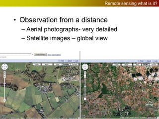
  • 1. Remote sensing what is it? • Observation from a distance – Aerial photographs- very detailed – Satellite images – global view
  • 2. Oblique aerial photograph • Viewed from an oblique angle: looking sideways • Looks natural, easy to understand, useless for measurement purposes
  • 3. Vertical aerial photograph • Viewed straight down giving a “map view” • Difficult to understand at first. Can be used as a basis of mapping, after image has been rectified
  • 5. Map derived form aerial photographs • Visible features are “digitised” by tracing around them on a computer screen. • This creates the points lines and polygon symbols which build up into the map
  • 6. Stereo-photography 3-d visualisation • Overlapping aerial photographs can be used to build 3-d stereoscopic visual models. These can be used to map out contours and heights of features Photo 1 Photo 2 Plane travels at constant altitude above sea level. Height above ground varies with topography overlap 60% of image
  • 7. Stereoscopic reconstruction of overlapping areas • A stereoscope is used to view the overlapping areas simultaneously and the brain builds a 3-d model of the landscape where the images overlap. Left eye Right eye Photo 1 Photo 2 overlap
  • 8. Digital manipulation of aerial photographs • 3-d models can also be built by “digitally draping” photographs over a digital elevation model of the landscape.
  • 9. Satellite Remote Sensing • Satellites give a higher viewpoint and give unrestricted coverage of the whole globe Link to Gateway Remote sensing video http://gateway.rac.ac.uk/mod/resource/view.php?id=3937
  • 10. Satellite orbits • Geostationary orbit: above the equator, 35,000 km height, orbital period 24 hours. Satellites appear fixed in sky • Low Earth orbit, usually polar, orbital period can be less than 1 hour. Satellites seen to move across sky
  • 11. Geo-stationary meteorological satellite: Meteosat • Geostationary orbits, approx 33,000 km elevation over the equator. Satellite takes 24hours for one orbit, the earth rotates once in that time, so the satellite appears stationary in the sky Infra-red image from 0600 March 8, 2000 “Ground” position of satellite
  • 12. Polar orbiting meteorological satellites • Polar orbiting satellites cover the whole globe, but move, so there are long time intervals between one image and the satellites next return
  • 13. Earth observation satellites: Landsat 7 image (30m resolution) • Earth observation satellites are designed to view the surface of the globe. Some are designed for view the oceans, others, like the Landsat series, observe the land
  • 14. 2004 tsunami: Aceh province, Sumatra
  • 15.
  • 16. Land classification; spectral signatures: Using SPOT images • Simultaneous Multi-spectral images can be used to classify landcover. • The reflectance of certain landcover types are measured on each image to build up a signature of that type of cover. This is then searched for over the whole image
  • 17. Land classification; spectral signatures: Using SPOT images • Simultaneous Multi-spectral images can be used to classify landcover. • The reflectance of certain landcover types are measured on each image to build up a signature of that type of cover. This is then searched for over the whole image
  • 18. Land classification; spectral signatures: Using SPOT images • Simultaneous Multi-spectral images can be used to classify landcover. • The reflectance of certain landcover types are measured on each image to build up a signature of that type of cover. This is then searched for over the whole image
  • 19. Land classification; spectral signatures: Using SPOT images • Simultaneous Multi-spectral images can be used to classify landcover. • The reflectance of certain landcover types are measured on each image to build up a signature of that type of cover. This is then searched for over the whole image
  • 21. Aerial photograph, 2011 Spatial resolution approx. 0.2m
  • 22. GoogleMaps aerial photo, Spatial resolution approx. 1.5m
  • 23. Scanned Aerial photograph, 1995 Spatial resolution approx. 2.0m
  • 24. Landsat 5 image, circa 2001 Spatial resolution approx. 30m
  • 25. LIDAR image, 2011 Spatial resolution approx. 1.0m Vertical resolution approx. 0.001m
  • 26. Landsat 5: 30m resolution • Landsat 5 image of Gloucestershire (Landsat 6 crashed on take off. Landsat 7 is current satellite, Landsat 8 has just been launched) Cheltenham Gloucester Harnhill Swindon
  • 27. Ikonos: 1m resolution • Commercial panchromatic image at 1m resolution. On the original image people can be seen walking in Horse Guards Parade and the spokes of the London Eye are visible
  • 28. Ikonos agricultural image 1m resolution • Another Ikonos image showing the detail available in an agricultural image, here form Montana • How useful is this for farmers?
  • 29. RADARSAT classified image of Flevoland, NL • Radar, “active remote sensing”, sees through clouds and in the dark. This addresses some of the major problems with “Passive remote sensing” which measures reflected sunlight. • The images are very difficult to interpret
  • 30. RADARSAT-Mozambique floods • Shuttle borne radar image of the Mozambique floods • Radar is good at detecting the edge of water bodies, which it can “see” through cloud cover
  • 31. Remote sensing summary • Aerial photography gives us a controllable, highly detailed view of the Earth • Satellite imagery gives global, unrestricted views which are repeated a frequent intervals • The references to actions such as “interpretation” and “classification” lead on to things we can do with a geographic information system (GIS) using remote sensing as a source of data