Enviar búsqueda
Cargar
Asia map study
•
Descargar como PPT, PDF
•
10 recomendaciones
•
20,756 vistas
L
lschmidt1170
Seguir
Denunciar
Compartir
Denunciar
Compartir
1 de 42
Descargar ahora
Recomendados
Today we explored the amazing cultures of Asia. Asia is the largest and most populated continent. We tasted the food that over 4 billion people eat each and every day.
Asia
Asia
guest591783
Report in Geography: ASIA
Geography: ASIA
Geography: ASIA
JamesChadric98
This is the list of important rivers in the world. This could help you while studying geography.If you like, share your ideas. you can also follow me::- rituparn (@rituparndreamz) | Twitter
World’s important rivers
Rituparn Masram
Geography of Asia
Geography of Asia
Geography of Asia
university of gujrat
A Informative ppt on Asia. there is information regarding physical and political divisions of asia.
Asia
Asia
Shobha Hassan
18.1 East Asia Physical Geography
mshyland
Asia, sub continents of asia, climate, physical division, location, climate, general geographic features, flora, fauna
ITFT- asia physical division
Aruna Poddar
Coastal plains
Coastal plains
abhishek1931jadhav
South Asia
South Asia
Donald Johnson
Antarctica introduction ppt
Kati W
Grade - 6 Geography Ch.6. continents and oceans The surface of the earth is covered with huge landmasses, known as continents, and large water bodies, known as oceans. While continents are part of lithosphere, oceans form the hydrosphere.
Grade - 6 Geography Ch.6. continents and oceans
Navya Rai
Physical features of asia
mrgupton1
north america
North america
North america
iqbal muhammed
Asia ~ Sir Bobby Ray Atmosfera
Asia
Asia
Alice Herman
Asia
Asia
AmritaArora48
Here is another creative presentation by your slide maker on the topic “Geography Of India". Hope you like it. If you like it then please, *like*, *Download* and *Share*. By- Slide_maker4u (Abhishek Sharma) *******For presentation Orders, contact me on the Email addresses Written below******** Email- Sharmaabhishek576@gmail.com or Sharmacomputers87@gmail.com *******THANK YOU***************
Geography of india
Geography of india
Abhishek Sharma
South america
South america
iambestbebs
The following presentation is on India's drainage or river system. It includes information about some of the major river systems in India. All comments are welcomed. Please LIKE this presentation.
PPT on India's Drainage System (River System)
Rohan Karmakar
Asia and its countries' descriptive names, culture, economy and history.
Asia
Asia
MamWamar_SHS Teacher/College Instructor at ESTI
“Continents are understood to be large, continuous, discrete masses of land, ideally separated by expanses of water.
Continents of the world
Moocs Engine
This is a Powerpoint Presentation on Arunachal Pradesh - The Land of Rising ... By Siddharth Kori
Arunachal Pradesh - The Land of Rising Sun.pptx
Siddharth Kori
Presentation on North America...........
North america
North america
saad shaikh
IN THIS SLIDE YOU WILL LEARN ABOUT INDIA'S SIZE, LOCATION, INDIA'S NEIGHBORHOOD AND INDIA IN THE WORLD.
INDIA - SIZE AND LOCATION
ADITYAAM1
pptx
Presentation on world
awaisbinsaeeed
summer vacation holiday Topic
Physical features of india
Bhumika Katyal
The coastal plains g
Jnana Prabodhini Educational Resource Center
The introductory PowerPoint for South America.
South America - Intro PPT
Matthew Lawhead
THE GREAT PLAINS, THE INDUS VALLEY PLAINS, INDO-GANGETIC PLAIN and THE NORTH CHINA PLAIN. BEST FOR 4TH GRADE STUDENTS.
Major plains of the world
Daniel Sam
Map of Asia Worksheet
BW Education & Innovation
S.N. J.M. J.D. Period 4
South East Asia (Global Presentation)
guest66ded8
Más contenido relacionado
La actualidad más candente
South Asia
South Asia
Donald Johnson
Antarctica introduction ppt
Kati W
Grade - 6 Geography Ch.6. continents and oceans The surface of the earth is covered with huge landmasses, known as continents, and large water bodies, known as oceans. While continents are part of lithosphere, oceans form the hydrosphere.
Grade - 6 Geography Ch.6. continents and oceans
Navya Rai
Physical features of asia
mrgupton1
north america
North america
North america
iqbal muhammed
Asia ~ Sir Bobby Ray Atmosfera
Asia
Asia
Alice Herman
Asia
Asia
AmritaArora48
Here is another creative presentation by your slide maker on the topic “Geography Of India". Hope you like it. If you like it then please, *like*, *Download* and *Share*. By- Slide_maker4u (Abhishek Sharma) *******For presentation Orders, contact me on the Email addresses Written below******** Email- Sharmaabhishek576@gmail.com or Sharmacomputers87@gmail.com *******THANK YOU***************
Geography of india
Geography of india
Abhishek Sharma
South america
South america
iambestbebs
The following presentation is on India's drainage or river system. It includes information about some of the major river systems in India. All comments are welcomed. Please LIKE this presentation.
PPT on India's Drainage System (River System)
Rohan Karmakar
Asia and its countries' descriptive names, culture, economy and history.
Asia
Asia
MamWamar_SHS Teacher/College Instructor at ESTI
“Continents are understood to be large, continuous, discrete masses of land, ideally separated by expanses of water.
Continents of the world
Moocs Engine
This is a Powerpoint Presentation on Arunachal Pradesh - The Land of Rising ... By Siddharth Kori
Arunachal Pradesh - The Land of Rising Sun.pptx
Siddharth Kori
Presentation on North America...........
North america
North america
saad shaikh
IN THIS SLIDE YOU WILL LEARN ABOUT INDIA'S SIZE, LOCATION, INDIA'S NEIGHBORHOOD AND INDIA IN THE WORLD.
INDIA - SIZE AND LOCATION
ADITYAAM1
pptx
Presentation on world
awaisbinsaeeed
summer vacation holiday Topic
Physical features of india
Bhumika Katyal
The coastal plains g
Jnana Prabodhini Educational Resource Center
The introductory PowerPoint for South America.
South America - Intro PPT
Matthew Lawhead
THE GREAT PLAINS, THE INDUS VALLEY PLAINS, INDO-GANGETIC PLAIN and THE NORTH CHINA PLAIN. BEST FOR 4TH GRADE STUDENTS.
Major plains of the world
Daniel Sam
La actualidad más candente
(20)
South Asia
South Asia
Antarctica introduction ppt
Grade - 6 Geography Ch.6. continents and oceans
Physical features of asia
North america
North america
Asia
Asia
Asia
Asia
Geography of india
Geography of india
South america
South america
PPT on India's Drainage System (River System)
Asia
Asia
Continents of the world
Arunachal Pradesh - The Land of Rising Sun.pptx
North america
North america
INDIA - SIZE AND LOCATION
Presentation on world
Physical features of india
The coastal plains g
South America - Intro PPT
Major plains of the world
Destacado
Map of Asia Worksheet
BW Education & Innovation
S.N. J.M. J.D. Period 4
South East Asia (Global Presentation)
guest66ded8
A comprehensive powerpoint on the geography of the Southeast Asian region. This was completed for a masters level course and is intended for community college or high school students. Includes many case studies from throughout Southeas Asia.
Southeast Asia Geography
Chris Calvert
Southeast asia updated
hmoulds
政治大學-社會科學學院-經濟政策研究中心:關於兩岸服務貿易協議的導讀與效益評估
兩岸服務貿易協議導讀與效益評估 (Cross-Strait Agreement on Trade in Service)
Timothy Tan
미국 NEH의 디지털인문학 프로젝트에 대한 상세리뷰
20140819 미국neh의디지털인문학 김바로
Baro Kim
sub saharan africa
Sub saharan africa
Sub saharan africa
Lisa Schmidt
Asia maps
Asia maps
Asia maps
Lisa Schmidt
Megalopolis map study
lschmidt1170
Of all systems, political organizations are the messiest and most complex. Tools such as the traditional Organizational Chart, Organigraph, and Business Model Canvas are grossly inadequate for mapping political organizations. The traditional Organizational Chart shows internal hierarchical relationships but does not show external customers or other stakeholders. An Organigraph is complex to draw and read primarily due to its freeform nature. The template of Business Model Canvas focuses on for-profit organizations and cannot capture the complexity of political organizations which are mainly platforms. This presentation presents two types of Organization Maps for political organizations: a Politics Periodic Table (PPT) and an Instant Organization Map (IOM). The former presents a comprehensive overview of political systems while the latter zooms in on particular political organization. Both types of Organization Maps are featured in this presentation with examples on the Government of the USA as well as Sierra Leone.
POLITICS PERIODIC TABLE (PPT): Instantly Map Every Political Organization in ...
Rod King, Ph.D.
Setting up a Growth Triangle between Timor-Leste, eastern Indonesia and northern Australia
Tia gt 2014-05_upld
Tia gt 2014-05_upld
Paulo Vieira
Recorded on January 23, 2013 - This webinar in the Family Law Education for Women (FLEW) series covers the basics of how the Children's Aid Society (CAS) system works, to give service providers and families an understanding of how they may take part in the process. For this discussion, METRAC's Legal Director, Tamar Witelson, is joined by Vicky Lowrey, a Senior Service Manager at the Children's Aid Society of Peel Region. Watch the webinar at: http://yourlegalrights.on.ca/webinar/understanding-childrens-aid-society-process-inside
Understanding the Children's Aid Society Process - From the Inside
Community Legal Education Ontario (CLEO)
Presentation contains up dated world map from continent wise to country wise at a glance (for beginners).along with Pakistan provincial and cities map. Data taken from world atlas.
Presenting world map at a glance
Lubna Arbi
Memorandum of Understanding on ASEAN Power Grid being established to strengthen and widen the mutual cooperation on electricity interconnection and trading between ASEAN countries with the purpose of region energy sector security and sustainability. This paper was presented for The President Republic of Indonesia as an academic background for Presidential Decree on Ratification of MOU on ASEAN Power Grid
ASEAN Power Grid
ASEAN Power Grid
Noezran Azwar
FTAs in South-east Asia: Towards the next generation is the second in a series of reports sponsored by HSBC that examines Asian businesses’ attitude towards free trade agreements (FTAs) and usage of their provisions. The report is based in part on the findings of a survey conducted in the first quarter of 2014 that included 400 exporters from four countries in the Association of South-East Asian Nations (ASEAN)—Indonesia, Malaysia, Singapore and Vietnam—representing a range of industries. Among its key findings, the report examines how the low usage rate of FTAs among ASEAN exporters is connected to the issue that many existing FTAs are “unambitious”—that is, they rarely go beyond simple tariff cutting to address issues such as trade in services, e-commerce, intellectual property rights, customs cooperation and other regulations that hinder trade—which means companies see limited upside in using them. Consequently many ASEAN businesses have high hopes for the next generation of “mega-regional” pacts now under negotiation, including the Trans-Pacific Partnership (TPP), and the formation of the ASEAN Economic Community in 2015. The report also finds that the liberalisation of trade in services is crucial to economic growth in the region. As supply chain fragmentation across ASEAN increases, trade becomes increasingly dependent on logistical, legal, financial and other services, which account for an increasingly large proportion of the value of goods shipped across borders. Better access to quality services would also help businesses expand into other markets.
FTAs in South-east Asia: Towards the next generation
The Economist Media Businesses
Political maps of countries
Malisa Gilbert
These are slides for Sec One students learning the history of Singapore. The focus is on 14th century maritime trade routes in Southeast Asia. Who travelled on them? What were the religious, trade and cultural ideas which influenced Southeast Asia. It also focused on the concept of exports. What is the historical evidence and archaeological evidence of the kind of goods that Singapore exported?
Southeast asian maritime trade
LLoyd Yeo
Diverse traditions of southeast asia
South High
Download Colorful Geographical World Map Powerpoint Templates- http://goo.gl/JKSnXA
Online Colorful Geographical World Map Powerpoint
Allyster Campbell
Introduction to world geography
World geography
World geography
MrO97
Destacado
(20)
Map of Asia Worksheet
South East Asia (Global Presentation)
Southeast Asia Geography
Southeast asia updated
兩岸服務貿易協議導讀與效益評估 (Cross-Strait Agreement on Trade in Service)
20140819 미국neh의디지털인문학 김바로
Sub saharan africa
Sub saharan africa
Asia maps
Asia maps
Megalopolis map study
POLITICS PERIODIC TABLE (PPT): Instantly Map Every Political Organization in ...
Tia gt 2014-05_upld
Tia gt 2014-05_upld
Understanding the Children's Aid Society Process - From the Inside
Presenting world map at a glance
ASEAN Power Grid
ASEAN Power Grid
FTAs in South-east Asia: Towards the next generation
Political maps of countries
Southeast asian maritime trade
Diverse traditions of southeast asia
Online Colorful Geographical World Map Powerpoint
World geography
World geography
Similar a Asia map study
Geography Of Asia
Geography Of Asia
North Gwinnett MA
Geography of asia
Geography of asia
North Gwinnett Middle School
Geographyof asia
Geographyof asia
Tammyperez20
Ss7 g9 landforms of southern and eastern asia
bhabyamy
Physical Geography of East Asia
1.geo eastasia
1.geo eastasia
Pinecrest Academy Nevada
Geogeaphy of eastern asia[1]
klgriffin
Chapter 27
Chapter 27
John Hext
Geography of china
Geography of china
Sanjeev Kumar
Unit One Of Asia Reg.
North Gwinnett MA
East Asia
East Asia
Mandy Rusch
(c) Maam Yanga
Asia
Asia
Karisse Ramoso
There are three majors of landform in Asia. Let see its discussion.
Asian landscapes
Asian landscapes
Thai Chamroeun
explanation of southeast Asia
SOUTH East Asia
SOUTH East Asia
Raja Haider
Chapter 30
Chapter 30
Ekart's World Geography
Year 9 Nelson Key Geography - Connections
China
China
helenachai
Asia
Asia
Asia
Jason Hauck
Chapter 27
Chapter 27
Ekart's World Geography
Let understand about ASIA'S description
Introducing asia
Introducing asia
Thai Chamroeun
From the largest region in china
Sinkiang or Xinjiang
Jen Gregana
Geography of china
Geography of china
UUM
Similar a Asia map study
(20)
Geography Of Asia
Geography Of Asia
Geography of asia
Geography of asia
Geographyof asia
Geographyof asia
Ss7 g9 landforms of southern and eastern asia
1.geo eastasia
1.geo eastasia
Geogeaphy of eastern asia[1]
Chapter 27
Chapter 27
Geography of china
Geography of china
Unit One Of Asia Reg.
East Asia
East Asia
Asia
Asia
Asian landscapes
Asian landscapes
SOUTH East Asia
SOUTH East Asia
Chapter 30
Chapter 30
China
China
Asia
Asia
Chapter 27
Chapter 27
Introducing asia
Introducing asia
Sinkiang or Xinjiang
Geography of china
Geography of china
Más de lschmidt1170
How did the magna carta influence the united states bill of rights
lschmidt1170
Sustainable development goals
lschmidt1170
Magna cartas lessons for the me
lschmidt1170
What is the magna carta and why there is a google doodle telegraph
lschmidt1170
Universal declaration of human rights
lschmidt1170
Magna carta and the law of nature
lschmidt1170
King john the most evil monarch in britain's history telegraph
lschmidt1170
How did the magna carta influence the united states bill of rights
lschmidt1170
Constitution bill of rights facts
Constitution billofrightsfacts
lschmidt1170
Feudal strength! henry ii and the struggle for royal control in
lschmidt1170
Constitution
Constitution
Constitution
lschmidt1170
Bill of rights
Bill of rights
Bill of rights
lschmidt1170
A magna carta for the earth
A magna carta for the earth oecd observer
lschmidt1170
Family History
Denis haley catherine douglas geneaology 1793 to 1989
lschmidt1170
North America Map One
Na map 1 with terms
Na map 1 with terms
lschmidt1170
intro
Introfall 2016 14week
lschmidt1170
syllabus
Fall 2016 syllabus geog 110 71
lschmidt1170
intro
Intro fall 2016 geog lab
lschmidt1170
intro
Fall 2016 intro wed
Fall 2016 intro wed
lschmidt1170
intro
Fall 2016 intro mon
Fall 2016 intro mon
lschmidt1170
Más de lschmidt1170
(20)
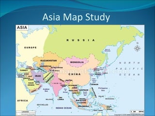
How did the magna carta influence the united states bill of rights
Sustainable development goals
Magna cartas lessons for the me
What is the magna carta and why there is a google doodle telegraph
Universal declaration of human rights
Magna carta and the law of nature
King john the most evil monarch in britain's history telegraph
How did the magna carta influence the united states bill of rights
Constitution billofrightsfacts
Feudal strength! henry ii and the struggle for royal control in
Constitution
Constitution
Bill of rights
Bill of rights
A magna carta for the earth oecd observer
Denis haley catherine douglas geneaology 1793 to 1989
Na map 1 with terms
Na map 1 with terms
Introfall 2016 14week
Fall 2016 syllabus geog 110 71
Intro fall 2016 geog lab
Fall 2016 intro wed
Fall 2016 intro wed
Fall 2016 intro mon
Fall 2016 intro mon
Asia map study
1.
Asia Map Study
2.
China Japan South
Korea Indonesia India Vietnam North Korea
3.
4.
5.
6.
7.
8.
9.
Indian Ocean
10.
11.
Bay of Bengal
12.
13.
Yellow Sea
14.
15.
SOUTH CHINA SEA
16.
17.
18.
19.
20.
21.
22.
Taklimakan Desert
23.
24.
Gobi Desert
25.
26.
27.
Korean Peninsula
28.
29.
30.
31.
32.
33.
34.
35.
36.
37.
38.
39.
40.
41.
42.
Descargar ahora