SlideShare una empresa de Scribd logo
1 de 33
Geography used to be associated with memorizing mind-numbing facts. Not any more!


                  Objectives and tools of
                  world regional geography
                  Chapter 1
1.1 Welcome to World Regional
Geography

   What is “Geography”?
       Term was first used by the Greek scholar
        Eratosthenes in the 3rd Century B.C.E.
       Literally means “Description of the Earth”
       Best summed up as “the study of the Earth as
        the home of humankind”
       Branches of the Discipline
           Physical Geography
           Human Geography
Subfields of Geography
1.1.1a 6 Essential Elements of Geography


   The World in Spatial Terms
   Places and Regions
   Physical Systems
   Human Systems
   Environment and Society
   Uses of Geography
1.1.1b Five Themes of Geography (NCGE)


   Location
   Place
   Human-Environment Interaction
   Movement
   Region
Ground Zero
  LOCATION:
  Lower Manhattan, New York                                               MOVEMENT:
  City                                           Before 9/11, daily comings and goings
  40°42’43” N 74°00’49” W                             of office workers in WTC; on 9/11,
                                                      diversion of airplanes to target the
                                                 buildings; after 9/11, flow of mourners,
                                                     tourists, construction crews to site.
 PLACE:
 Formerly, office buildings at heart
 of one of world’s great financial
 centers; now, a place of historical
 significance and collective grief                                            REGION:
 for Americans.                                         Situated in region of U.S. known
                                                            as the Northeast, in a humid
                                                              continental climate region.


HUMAN-ENVIRONMENT INTERACTION:
Lower Manhattan occupies low-lying ground that was once
marshy swampland. Construction of the twin towers of the
World Trade Center required special foundations to keep
the Hudson River’s water from pouring in.
1.1.2 Human-Environment Interaction


   So many of Earth’s most pressing problems (climate
    change, population growth, hunger, etc.) involve the
    coupling of human and environmental systems
   Important early geographers
       Alexander von Humboldt (German)
       Carl Sauer (American)
           Founded landscape perspective in American geography
           Study the transformation through time of a natural
            landscape to a cultural landscape
   Landscape
       Physical and human features on the Earth’s surface
   Culture underlies decisions about use of landscape
       System of values, beliefs, and attitudes that shapes and
        influences perception and behavior
1.1.3 The World Regional Approach


   This text divides the earth into 8 world regions
   People create and draw boundaries around regions that
    share relatively similar characteristics. A region is
    simply a convenience and a generalization.
   Types of Regions Used by Geographers
       Formal Region (uniform / homogeneous)
           Population shares a defining trait(s)
       Functional Region (nodal)
           Spatial unit characterized by a
            central focus on some activity
       Vernacular Region (perceptual)
           Exists in the minds of many people
  Various interpretations of the
American South as a vernacular
                         region
World Regions
Profile of the World Regions
1.1.4 Objectives of This Book


   To understand Earth’s problems and
    potential solutions for these problems
   To develop a habit of synthesizing
    information to understand the world
   To understand current events
   To develop the ability to interpret places
    and “read” landscapes
Reading the Landscape

Where is this place?

What clues on the landscape or in the
man’s appearance might tell you where
you are?
1.2 The Language of Maps


   A map is a representation of various phenomena
    over all or a part of the Earth’s surface, usually
    rendered on a flat surface such as paper or a
    computer monitor.
   Maps are essential tools of geographers
       Help in understanding the spatial context of things
   Cartography
       Art and Science of Making Maps
   Map Elements
       Scale
       Coordinate Systems
       Projections
       Symbolization
1.2.1 Scale


   Scale
       The size ratio represented by a map
   Representative Fraction
       A map with a scale of 1:10,000 means that 1 linear
        unit (e.g., inch or cm) on the map represents 10,000
        such real-world units on the ground
       Large Scale
           Large Representative Fraction (ex: 1:10,000 or 1:100)
           Small Area Shown in More Detail
       Small Scale
           Small Representative Fraction (ex: 1:1,000,000)
           Large Area Shown in More Generalized Terms
Comparison of Map Scales


    Small-Scale Map                 Large-Scale Map
Small Representative Fraction   Large Representative Fraction
    Portrays Large Area              Portrays Small Area
1.2.2 Coordinate Systems


   Location
       Relative   Defines a place in relationship to other places
       Absolute   Provides a unique address for each place
   Coordinate System
       Grids of horizontal and vertical lines covering the globe
       Intersections of these lines create the addresses
       Latitude and Longitude most commonly used
       Measured in Degrees (°), Minutes (’), and Seconds (”)
         1 Degree is made up of 60 Minutes
         1 Minute is made up of 60 Seconds
1.2.2 Coordinate Systems - Latitude


   Equator has a latitude of 0°
       The equator and all other latitudinal lines are parallel to
        each other, which is why they are called parallels
       Divides Northern and Southern Hemispheres
   Important Latitudes
       North Pole                      90.00° North
       Arctic Circle                   66.56° North
       Tropic of Cancer                23.44° North
       Equator                          0.00°
       Tropic of Capricorn             23.44° South
       Antarctic Circle                66.56° South
       South Pole                      90.00° South
1.2.2 Coordinate Systems - Longitude


   Meridians of Longitude
       Straight lines connecting the poles
       Converge at the poles; farthest apart at Equator
   Prime Meridian has a longitude of 0°
       Runs through the Royal Astronomical Observatory in
        Greenwich, England
       Divides Western and Eastern Hemispheres
   International Date Line has a longitude of 180°
       Halfway around the world from the Prime Meridian
       Separates two consecutive calendar days
Latitude vs. Longitude


Parallels of Latitude       Meridians of Longitude
Range from 90°N to 90°S      Range from 180°W to 180°E
    Equator at 0°               Prime Meridian at 0°
Hemispheres: Half Worlds Apart


   Land Hemisphere                 Water Hemisphere
80% of the World’s Land Area    20% of the World’s Land Area
90% of the World’s Population   10% of the World’s Population
What are the approximate
  latitude & longitude
  coordinates for these
    European cities?
1.2.3 Projections


   Map Projection
       Way of depicting the curved surface of the earth on a flat
        surface, such as a piece of paper
   Metric Relationships on the Globe
       Area, Shape, Distance, Direction
       A flat map cannot replicate all of these simultaneously
       Most projections can preserve only one of these
       Inevitably, there will be distortion on a flat map
   Common Map Projection Families:
       Azimuthal       Plane, Polar Regions
       Cylindrical     Cylinder, Areas around the Equator
       Conic           Cone, Middle Latitudes
Common Map Projections
1.2.4 Symbolization


   Maps and Symbolization
       Cartographic Abstraction
           No map is a complete record of an area
           Symbols used to represent a selection of certain important details
           All maps must “lie” to some degree to inform their readers
   Reference Maps
       Concerned with locations of various
        features of the earth’s surface and
        their relationships with each other
   Thematic Maps
       Show the distribution of a
        particular phenomenon
Reference Map
Thematic Map                Choropleth Map


  Each country is filled in with a distinguishing color
       representing its Per Capita GNI PPP.
Thematic Map                     Isarithmic Map


Instead of using political boundaries, shading is applied to areas having similar
     amounts of the variable being mapped, in this case population density.
Thematic Map                Graduated Symbol Map


          Symbols can be scaled proportionally to the quantity
           of the data being mapped. In the cartogram above
   (a specific type of graduated symbol map), the countries have been
                    resized based on relative population.
1.3 Geographic Technologies and Careers

   Recent technological advances in geography have been
    dubbed “The Geospatial Revolution”
   Geographic Information Systems (GIS)
       Computer-based tool that allows people to create, view,
        manipulate, analyze, and store geospatial data
       Spatial data stored in “Layers”
           Soils, Hydrology, Road Networks, Demographics, etc.
   Global Positioning Systems (GPS)
   Remote Sensing (Earth Observation)
       Science of acquiring information about the Earth’s surface
        without being in direct contact with it
       Data Sources
           Aerial Photography
           Radar
           LIDAR
Geographic Information Systems at Work
1.3.1 Careers in Geography


   US Department of Labor identified geospatial
    technology as one of the most important
    emerging and evolving fields in the
    technology industry
   Anticipated 20% job growth through 2018 in
    jobs for geographers, geoscientists,
    cartographers, urban and regional planners,
    and other geographic professionals
               “We are living in the era of the
                                 geographer.”
Transportation
   Planner
                      USGS Water
                       Specialist


  GIS Analyst        Natural Science
                        Teacher


Nature Conservancy     Geospatial
 Preserve Manager       Engineer


                      Cartographer
   Geography
    Professor
Google Earth
http://www.earth.google.com/

Más contenido relacionado

La actualidad más candente

AP Human Geography: Unit 1 - Introduction to Geography
AP Human Geography: Unit 1 - Introduction to GeographyAP Human Geography: Unit 1 - Introduction to Geography
AP Human Geography: Unit 1 - Introduction to GeographyDaniel Eiland
 
Intro to world geography skills
Intro to world geography skillsIntro to world geography skills
Intro to world geography skillskarrinem
 
Geo: Unit 1, Chapter 1 Powerpoint
Geo: Unit 1, Chapter 1 PowerpointGeo: Unit 1, Chapter 1 Powerpoint
Geo: Unit 1, Chapter 1 PowerpointMr. Philen
 
World geography
World geographyWorld geography
World geographyMrO97
 
Lecture ch01a geography matters
Lecture ch01a geography mattersLecture ch01a geography matters
Lecture ch01a geography mattersSusan White
 
Ch 1 outline terms - Location and Spatial Analysis
Ch 1 outline terms - Location and Spatial AnalysisCh 1 outline terms - Location and Spatial Analysis
Ch 1 outline terms - Location and Spatial AnalysisSusan White
 
Exploring our geographic world by tessie calimag bb.
Exploring our geographic world by tessie calimag bb.Exploring our geographic world by tessie calimag bb.
Exploring our geographic world by tessie calimag bb.Tessie Calimag
 
The Geographer's Toolbox
The Geographer's ToolboxThe Geographer's Toolbox
The Geographer's ToolboxSandy Anthony
 
Surveying II ajith sir class 1
Surveying II ajith sir class 1Surveying II ajith sir class 1
Surveying II ajith sir class 1SHAMJITH KM
 

La actualidad más candente (20)

Map Projections
Map ProjectionsMap Projections
Map Projections
 
Map & globes
Map & globesMap & globes
Map & globes
 
AP Human Geography: Unit 1 - Introduction to Geography
AP Human Geography: Unit 1 - Introduction to GeographyAP Human Geography: Unit 1 - Introduction to Geography
AP Human Geography: Unit 1 - Introduction to Geography
 
Intro to world geography skills
Intro to world geography skillsIntro to world geography skills
Intro to world geography skills
 
Geo: Unit 1, Chapter 1 Powerpoint
Geo: Unit 1, Chapter 1 PowerpointGeo: Unit 1, Chapter 1 Powerpoint
Geo: Unit 1, Chapter 1 Powerpoint
 
Ch02
Ch02Ch02
Ch02
 
World geography
World geographyWorld geography
World geography
 
Class1b
Class1bClass1b
Class1b
 
Map projections
Map projectionsMap projections
Map projections
 
Lecture ch01a geography matters
Lecture ch01a geography mattersLecture ch01a geography matters
Lecture ch01a geography matters
 
Ch 1 outline terms - Location and Spatial Analysis
Ch 1 outline terms - Location and Spatial AnalysisCh 1 outline terms - Location and Spatial Analysis
Ch 1 outline terms - Location and Spatial Analysis
 
Chapter two
Chapter twoChapter two
Chapter two
 
Map projections
Map projectionsMap projections
Map projections
 
Maps Ppt
Maps PptMaps Ppt
Maps Ppt
 
Exploring our geographic world by tessie calimag bb.
Exploring our geographic world by tessie calimag bb.Exploring our geographic world by tessie calimag bb.
Exploring our geographic world by tessie calimag bb.
 
Map Projection
Map ProjectionMap Projection
Map Projection
 
The Geographer's Toolbox
The Geographer's ToolboxThe Geographer's Toolbox
The Geographer's Toolbox
 
Datum
DatumDatum
Datum
 
Surveying II ajith sir class 1
Surveying II ajith sir class 1Surveying II ajith sir class 1
Surveying II ajith sir class 1
 
Chapter 1 rubenstein
Chapter 1 rubensteinChapter 1 rubenstein
Chapter 1 rubenstein
 

Destacado (20)

Ch 1 worksheet
Ch 1 worksheetCh 1 worksheet
Ch 1 worksheet
 
Thenationalgeographystandards
ThenationalgeographystandardsThenationalgeographystandards
Thenationalgeographystandards
 
Carl sauer
Carl sauerCarl sauer
Carl sauer
 
Geography basics
Geography basicsGeography basics
Geography basics
 
Lab three map scale
Lab three map scaleLab three map scale
Lab three map scale
 
Ch15
Ch15Ch15
Ch15
 
Intro fall 2016 geog lab
Intro fall 2016 geog labIntro fall 2016 geog lab
Intro fall 2016 geog lab
 
Ch18
Ch18Ch18
Ch18
 
Cheffey geog 4 intro spr 2013
Cheffey geog 4 intro spr 2013Cheffey geog 4 intro spr 2013
Cheffey geog 4 intro spr 2013
 
Geog 110 sp 2013 intro
Geog 110 sp 2013 introGeog 110 sp 2013 intro
Geog 110 sp 2013 intro
 
Ch01
Ch01Ch01
Ch01
 
Geog 4 summer 2013
Geog 4 summer 2013Geog 4 summer 2013
Geog 4 summer 2013
 
Ch05
Ch05Ch05
Ch05
 
Intro geog 110 online fall 2016
Intro geog 110 online fall 2016Intro geog 110 online fall 2016
Intro geog 110 online fall 2016
 
Sbvc intro geog 120 sp 2013
Sbvc intro geog 120 sp 2013Sbvc intro geog 120 sp 2013
Sbvc intro geog 120 sp 2013
 
Ch20
Ch20Ch20
Ch20
 
Measuring scale on OS Maps
Measuring scale on OS MapsMeasuring scale on OS Maps
Measuring scale on OS Maps
 
Human geography10
Human geography10Human geography10
Human geography10
 
Ch 5
Ch 5Ch 5
Ch 5
 
Human geography11
Human geography11Human geography11
Human geography11
 

Similar a Ch 1

Practical work in geography
Practical work in geographyPractical work in geography
Practical work in geographyShivam Kapri
 
RebekahHannonMapSkillsTutorial
RebekahHannonMapSkillsTutorialRebekahHannonMapSkillsTutorial
RebekahHannonMapSkillsTutoriallanderbraves
 
Chapter 1, Section 2
Chapter 1, Section 2Chapter 1, Section 2
Chapter 1, Section 2Mr. Philen
 
Exploring our geographic world by tessie calimag bb.
Exploring our geographic world by tessie calimag bb.Exploring our geographic world by tessie calimag bb.
Exploring our geographic world by tessie calimag bb.Tessie Calimag
 
5 themes and map skills
5 themes and map skills 5 themes and map skills
5 themes and map skills Úcar Marian
 
Maps as Models of Earth
Maps as Models of EarthMaps as Models of Earth
Maps as Models of Earthmlong24
 
Maps as Models of Earth
Maps as Models of EarthMaps as Models of Earth
Maps as Models of Earthmlong24
 
BOLTSS - Mapping Geography
BOLTSS - Mapping GeographyBOLTSS - Mapping Geography
BOLTSS - Mapping GeographyYaryalitsa
 
EssentialsGeographyCoakley
EssentialsGeographyCoakleyEssentialsGeographyCoakley
EssentialsGeographyCoakleyCorrineCoakley1
 
Ch. 1.2--Geographer's Tools
Ch. 1.2--Geographer's ToolsCh. 1.2--Geographer's Tools
Ch. 1.2--Geographer's ToolsJohn Hext
 
Graphic representation of the earth . maps and globe
Graphic representation of the earth . maps and globeGraphic representation of the earth . maps and globe
Graphic representation of the earth . maps and globeFerdinand Agdoro Jr.
 
gwg_chapter_01 (1).ppt
gwg_chapter_01 (1).pptgwg_chapter_01 (1).ppt
gwg_chapter_01 (1).pptChrisFuller66
 

Similar a Ch 1 (20)

Chapter1
Chapter1Chapter1
Chapter1
 
Exploring geography
Exploring geographyExploring geography
Exploring geography
 
Map reading
Map readingMap reading
Map reading
 
#2 Maps
#2 Maps#2 Maps
#2 Maps
 
Exploring geographic world
Exploring geographic worldExploring geographic world
Exploring geographic world
 
Practical work in geography
Practical work in geographyPractical work in geography
Practical work in geography
 
RebekahHannonMapSkillsTutorial
RebekahHannonMapSkillsTutorialRebekahHannonMapSkillsTutorial
RebekahHannonMapSkillsTutorial
 
Chapter 1, Section 2
Chapter 1, Section 2Chapter 1, Section 2
Chapter 1, Section 2
 
Exploring our geographic world by tessie calimag bb.
Exploring our geographic world by tessie calimag bb.Exploring our geographic world by tessie calimag bb.
Exploring our geographic world by tessie calimag bb.
 
5 themes and map skills
5 themes and map skills 5 themes and map skills
5 themes and map skills
 
Maps as Models of Earth
Maps as Models of EarthMaps as Models of Earth
Maps as Models of Earth
 
Maps as Models of Earth
Maps as Models of EarthMaps as Models of Earth
Maps as Models of Earth
 
BOLTSS - Mapping Geography
BOLTSS - Mapping GeographyBOLTSS - Mapping Geography
BOLTSS - Mapping Geography
 
EssentialsGeographyCoakley
EssentialsGeographyCoakleyEssentialsGeographyCoakley
EssentialsGeographyCoakley
 
Introduction of Season Oceanography
Introduction of Season OceanographyIntroduction of Season Oceanography
Introduction of Season Oceanography
 
Ch. 1.2--Geographer's Tools
Ch. 1.2--Geographer's ToolsCh. 1.2--Geographer's Tools
Ch. 1.2--Geographer's Tools
 
Graphic representation of the earth . maps and globe
Graphic representation of the earth . maps and globeGraphic representation of the earth . maps and globe
Graphic representation of the earth . maps and globe
 
Projection
ProjectionProjection
Projection
 
gwg_chapter_01 (1).ppt
gwg_chapter_01 (1).pptgwg_chapter_01 (1).ppt
gwg_chapter_01 (1).ppt
 
Geography Handbook
Geography HandbookGeography Handbook
Geography Handbook
 

Más de lschmidt1170

How did the magna carta influence the united states bill of rights
How did the magna carta influence the united states bill of rightsHow did the magna carta influence the united states bill of rights
How did the magna carta influence the united states bill of rightslschmidt1170
 
Sustainable development goals
Sustainable development goalsSustainable development goals
Sustainable development goalslschmidt1170
 
Magna cartas lessons for the me
Magna cartas lessons for the meMagna cartas lessons for the me
Magna cartas lessons for the melschmidt1170
 
What is the magna carta and why there is a google doodle telegraph
What is the magna carta and why there is a google doodle    telegraphWhat is the magna carta and why there is a google doodle    telegraph
What is the magna carta and why there is a google doodle telegraphlschmidt1170
 
Universal declaration of human rights
Universal declaration of human rightsUniversal declaration of human rights
Universal declaration of human rightslschmidt1170
 
Magna carta and the law of nature
Magna carta and the law of natureMagna carta and the law of nature
Magna carta and the law of naturelschmidt1170
 
King john the most evil monarch in britain's history telegraph
King john  the most evil monarch in britain's history   telegraphKing john  the most evil monarch in britain's history   telegraph
King john the most evil monarch in britain's history telegraphlschmidt1170
 
How did the magna carta influence the united states bill of rights
How did the magna carta influence the united states bill of rightsHow did the magna carta influence the united states bill of rights
How did the magna carta influence the united states bill of rightslschmidt1170
 
Constitution billofrightsfacts
Constitution billofrightsfactsConstitution billofrightsfacts
Constitution billofrightsfactslschmidt1170
 
Feudal strength! henry ii and the struggle for royal control in
Feudal strength!  henry ii and the struggle for royal control inFeudal strength!  henry ii and the struggle for royal control in
Feudal strength! henry ii and the struggle for royal control inlschmidt1170
 
A magna carta for the earth oecd observer
A magna carta for the earth    oecd observerA magna carta for the earth    oecd observer
A magna carta for the earth oecd observerlschmidt1170
 
Denis haley catherine douglas geneaology 1793 to 1989
Denis haley catherine douglas geneaology 1793 to 1989Denis haley catherine douglas geneaology 1793 to 1989
Denis haley catherine douglas geneaology 1793 to 1989lschmidt1170
 
Na map 1 with terms
Na map 1 with termsNa map 1 with terms
Na map 1 with termslschmidt1170
 
Introfall 2016 14week
Introfall 2016 14weekIntrofall 2016 14week
Introfall 2016 14weeklschmidt1170
 
Fall 2016 syllabus geog 110 71
Fall 2016 syllabus geog 110 71Fall 2016 syllabus geog 110 71
Fall 2016 syllabus geog 110 71lschmidt1170
 
Fall 2016 intro wed
Fall 2016 intro wedFall 2016 intro wed
Fall 2016 intro wedlschmidt1170
 
Fall 2016 intro mon
Fall 2016 intro monFall 2016 intro mon
Fall 2016 intro monlschmidt1170
 
Fall 2016 geog 101 l syllabus we
Fall 2016 geog 101 l syllabus weFall 2016 geog 101 l syllabus we
Fall 2016 geog 101 l syllabus welschmidt1170
 

Más de lschmidt1170 (20)

How did the magna carta influence the united states bill of rights
How did the magna carta influence the united states bill of rightsHow did the magna carta influence the united states bill of rights
How did the magna carta influence the united states bill of rights
 
Sustainable development goals
Sustainable development goalsSustainable development goals
Sustainable development goals
 
Magna cartas lessons for the me
Magna cartas lessons for the meMagna cartas lessons for the me
Magna cartas lessons for the me
 
What is the magna carta and why there is a google doodle telegraph
What is the magna carta and why there is a google doodle    telegraphWhat is the magna carta and why there is a google doodle    telegraph
What is the magna carta and why there is a google doodle telegraph
 
Universal declaration of human rights
Universal declaration of human rightsUniversal declaration of human rights
Universal declaration of human rights
 
Magna carta and the law of nature
Magna carta and the law of natureMagna carta and the law of nature
Magna carta and the law of nature
 
King john the most evil monarch in britain's history telegraph
King john  the most evil monarch in britain's history   telegraphKing john  the most evil monarch in britain's history   telegraph
King john the most evil monarch in britain's history telegraph
 
How did the magna carta influence the united states bill of rights
How did the magna carta influence the united states bill of rightsHow did the magna carta influence the united states bill of rights
How did the magna carta influence the united states bill of rights
 
Constitution billofrightsfacts
Constitution billofrightsfactsConstitution billofrightsfacts
Constitution billofrightsfacts
 
Feudal strength! henry ii and the struggle for royal control in
Feudal strength!  henry ii and the struggle for royal control inFeudal strength!  henry ii and the struggle for royal control in
Feudal strength! henry ii and the struggle for royal control in
 
Constitution
ConstitutionConstitution
Constitution
 
Bill of rights
Bill of rightsBill of rights
Bill of rights
 
A magna carta for the earth oecd observer
A magna carta for the earth    oecd observerA magna carta for the earth    oecd observer
A magna carta for the earth oecd observer
 
Denis haley catherine douglas geneaology 1793 to 1989
Denis haley catherine douglas geneaology 1793 to 1989Denis haley catherine douglas geneaology 1793 to 1989
Denis haley catherine douglas geneaology 1793 to 1989
 
Na map 1 with terms
Na map 1 with termsNa map 1 with terms
Na map 1 with terms
 
Introfall 2016 14week
Introfall 2016 14weekIntrofall 2016 14week
Introfall 2016 14week
 
Fall 2016 syllabus geog 110 71
Fall 2016 syllabus geog 110 71Fall 2016 syllabus geog 110 71
Fall 2016 syllabus geog 110 71
 
Fall 2016 intro wed
Fall 2016 intro wedFall 2016 intro wed
Fall 2016 intro wed
 
Fall 2016 intro mon
Fall 2016 intro monFall 2016 intro mon
Fall 2016 intro mon
 
Fall 2016 geog 101 l syllabus we
Fall 2016 geog 101 l syllabus weFall 2016 geog 101 l syllabus we
Fall 2016 geog 101 l syllabus we
 

Ch 1

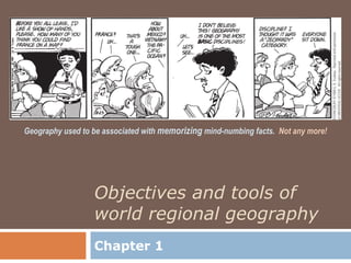
  • 1. Geography used to be associated with memorizing mind-numbing facts. Not any more! Objectives and tools of world regional geography Chapter 1
  • 2. 1.1 Welcome to World Regional Geography  What is “Geography”?  Term was first used by the Greek scholar Eratosthenes in the 3rd Century B.C.E.  Literally means “Description of the Earth”  Best summed up as “the study of the Earth as the home of humankind”  Branches of the Discipline  Physical Geography  Human Geography
  • 4. 1.1.1a 6 Essential Elements of Geography  The World in Spatial Terms  Places and Regions  Physical Systems  Human Systems  Environment and Society  Uses of Geography
  • 5. 1.1.1b Five Themes of Geography (NCGE)  Location  Place  Human-Environment Interaction  Movement  Region
  • 6. Ground Zero LOCATION: Lower Manhattan, New York MOVEMENT: City Before 9/11, daily comings and goings 40°42’43” N 74°00’49” W of office workers in WTC; on 9/11, diversion of airplanes to target the buildings; after 9/11, flow of mourners, tourists, construction crews to site. PLACE: Formerly, office buildings at heart of one of world’s great financial centers; now, a place of historical significance and collective grief REGION: for Americans. Situated in region of U.S. known as the Northeast, in a humid continental climate region. HUMAN-ENVIRONMENT INTERACTION: Lower Manhattan occupies low-lying ground that was once marshy swampland. Construction of the twin towers of the World Trade Center required special foundations to keep the Hudson River’s water from pouring in.
  • 7. 1.1.2 Human-Environment Interaction  So many of Earth’s most pressing problems (climate change, population growth, hunger, etc.) involve the coupling of human and environmental systems  Important early geographers  Alexander von Humboldt (German)  Carl Sauer (American)  Founded landscape perspective in American geography  Study the transformation through time of a natural landscape to a cultural landscape  Landscape  Physical and human features on the Earth’s surface  Culture underlies decisions about use of landscape  System of values, beliefs, and attitudes that shapes and influences perception and behavior
  • 8. 1.1.3 The World Regional Approach  This text divides the earth into 8 world regions  People create and draw boundaries around regions that share relatively similar characteristics. A region is simply a convenience and a generalization.  Types of Regions Used by Geographers  Formal Region (uniform / homogeneous)  Population shares a defining trait(s)  Functional Region (nodal)  Spatial unit characterized by a central focus on some activity  Vernacular Region (perceptual)  Exists in the minds of many people Various interpretations of the American South as a vernacular region
  • 10. Profile of the World Regions
  • 11. 1.1.4 Objectives of This Book  To understand Earth’s problems and potential solutions for these problems  To develop a habit of synthesizing information to understand the world  To understand current events  To develop the ability to interpret places and “read” landscapes
  • 12. Reading the Landscape Where is this place? What clues on the landscape or in the man’s appearance might tell you where you are?
  • 13. 1.2 The Language of Maps  A map is a representation of various phenomena over all or a part of the Earth’s surface, usually rendered on a flat surface such as paper or a computer monitor.  Maps are essential tools of geographers  Help in understanding the spatial context of things  Cartography  Art and Science of Making Maps  Map Elements  Scale  Coordinate Systems  Projections  Symbolization
  • 14. 1.2.1 Scale  Scale  The size ratio represented by a map  Representative Fraction  A map with a scale of 1:10,000 means that 1 linear unit (e.g., inch or cm) on the map represents 10,000 such real-world units on the ground  Large Scale  Large Representative Fraction (ex: 1:10,000 or 1:100)  Small Area Shown in More Detail  Small Scale  Small Representative Fraction (ex: 1:1,000,000)  Large Area Shown in More Generalized Terms
  • 15. Comparison of Map Scales Small-Scale Map Large-Scale Map Small Representative Fraction Large Representative Fraction Portrays Large Area Portrays Small Area
  • 16. 1.2.2 Coordinate Systems  Location  Relative Defines a place in relationship to other places  Absolute Provides a unique address for each place  Coordinate System  Grids of horizontal and vertical lines covering the globe  Intersections of these lines create the addresses  Latitude and Longitude most commonly used  Measured in Degrees (°), Minutes (’), and Seconds (”)  1 Degree is made up of 60 Minutes  1 Minute is made up of 60 Seconds
  • 17. 1.2.2 Coordinate Systems - Latitude  Equator has a latitude of 0°  The equator and all other latitudinal lines are parallel to each other, which is why they are called parallels  Divides Northern and Southern Hemispheres  Important Latitudes  North Pole 90.00° North  Arctic Circle 66.56° North  Tropic of Cancer 23.44° North  Equator 0.00°  Tropic of Capricorn 23.44° South  Antarctic Circle 66.56° South  South Pole 90.00° South
  • 18. 1.2.2 Coordinate Systems - Longitude  Meridians of Longitude  Straight lines connecting the poles  Converge at the poles; farthest apart at Equator  Prime Meridian has a longitude of 0°  Runs through the Royal Astronomical Observatory in Greenwich, England  Divides Western and Eastern Hemispheres  International Date Line has a longitude of 180°  Halfway around the world from the Prime Meridian  Separates two consecutive calendar days
  • 19. Latitude vs. Longitude Parallels of Latitude Meridians of Longitude Range from 90°N to 90°S Range from 180°W to 180°E Equator at 0° Prime Meridian at 0°
  • 20. Hemispheres: Half Worlds Apart Land Hemisphere Water Hemisphere 80% of the World’s Land Area 20% of the World’s Land Area 90% of the World’s Population 10% of the World’s Population
  • 21. What are the approximate latitude & longitude coordinates for these European cities?
  • 22. 1.2.3 Projections  Map Projection  Way of depicting the curved surface of the earth on a flat surface, such as a piece of paper  Metric Relationships on the Globe  Area, Shape, Distance, Direction  A flat map cannot replicate all of these simultaneously  Most projections can preserve only one of these  Inevitably, there will be distortion on a flat map  Common Map Projection Families:  Azimuthal Plane, Polar Regions  Cylindrical Cylinder, Areas around the Equator  Conic Cone, Middle Latitudes
  • 24. 1.2.4 Symbolization  Maps and Symbolization  Cartographic Abstraction  No map is a complete record of an area  Symbols used to represent a selection of certain important details  All maps must “lie” to some degree to inform their readers  Reference Maps  Concerned with locations of various features of the earth’s surface and their relationships with each other  Thematic Maps  Show the distribution of a particular phenomenon
  • 26. Thematic Map Choropleth Map Each country is filled in with a distinguishing color representing its Per Capita GNI PPP.
  • 27. Thematic Map Isarithmic Map Instead of using political boundaries, shading is applied to areas having similar amounts of the variable being mapped, in this case population density.
  • 28. Thematic Map Graduated Symbol Map Symbols can be scaled proportionally to the quantity of the data being mapped. In the cartogram above (a specific type of graduated symbol map), the countries have been resized based on relative population.
  • 29. 1.3 Geographic Technologies and Careers  Recent technological advances in geography have been dubbed “The Geospatial Revolution”  Geographic Information Systems (GIS)  Computer-based tool that allows people to create, view, manipulate, analyze, and store geospatial data  Spatial data stored in “Layers”  Soils, Hydrology, Road Networks, Demographics, etc.  Global Positioning Systems (GPS)  Remote Sensing (Earth Observation)  Science of acquiring information about the Earth’s surface without being in direct contact with it  Data Sources  Aerial Photography  Radar  LIDAR
  • 31. 1.3.1 Careers in Geography  US Department of Labor identified geospatial technology as one of the most important emerging and evolving fields in the technology industry  Anticipated 20% job growth through 2018 in jobs for geographers, geoscientists, cartographers, urban and regional planners, and other geographic professionals “We are living in the era of the geographer.”
  • 32. Transportation Planner USGS Water Specialist GIS Analyst Natural Science Teacher Nature Conservancy Geospatial Preserve Manager Engineer Cartographer Geography Professor