Faröe Islands: Scenic Archipelago Between Scotland and Iceland
•Descargar como PPT, PDF•
6 recomendaciones•1,811 vistas


Recomendados
Más contenido relacionado
La actualidad más candente
La actualidad más candente (12)
Destacado
Similar a Faröe Islands: Scenic Archipelago Between Scotland and Iceland
Similar a Faröe Islands: Scenic Archipelago Between Scotland and Iceland (20)
Más de Mario Ricca
Más de Mario Ricca (20)
Último
Último (20)
Faröe Islands: Scenic Archipelago Between Scotland and Iceland
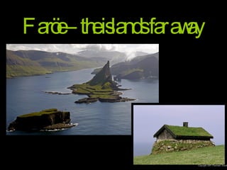
- 1. Faröe – the islands far away
- 2. Situated half way between Scotland and Iceland in the Northeast Atlantic, the Faröe Islands ( Føroyar , meaning “Sheep Islands”) are an archipelago of 18 mountainous islands, with a total land area of some 1400 Km 2 and a population of just over 47 000. The language of the Faröe Islands, Faroese, is a Nordic language derived from the language of the Norsemen who settled the islands 1200 years ago.
- 3. These include the living marine resources, trade, fiscal, industrial and environmental policies, transport, communications, culture, education and research. As a self-governing territory under the sovereignty of Denmark, the Faröe Islands legislate and govern a wide range of areas.
- 7. Tinganes is the historic location of the Faroese løgting (parliament), and is now part of Tórshavn. The name means "parliament point" in Faroese .
- 8. Tinganes is now an area consisting of government offices and residental dwellings . http://www.rgu.ac.uk/sss/research/page.cfm?pge=32685
- 19. Tórshavn's dome church, the Havnar Kirkja.
- 22. Torshavn’s west harbour Vestaravág
- 24. The east harbour Eystaravág
- 27. The east port at dawn
- 29. Café Natur is an unexpensive pub with very good beer and decent food. Very good for breakfast.
- 31. The national park at Tórshavn, one of the few places where you can find trees
- 35. The village of Nólsoy (pop 40) 20 minutes from Tórshavn by ferry
- 37. In recent years many young families have moved from Tórshavn to Nólsoy where the houses are cheaper
- 39. Sheep at Nólsoy island
- 40. Nólsoy - church
- 43. Eysturoy farm
- 44. Eiði pop. 652
- 45. House in Eiði , on the n orth-west tip of Eysturoy island.
- 46. THIS is green!
- 48. ‘ Risin og Kellingin’ , the giant and the witch, near Eiði in Esturoy island.
- 50. Faröe sheep in Esturoy
- 53. The church in Gjógv is from 1929
- 55. Gjógv
- 61. Cliff near Gjógv
- 62. Leirvik (pop. 870) in Esturoy east coast
- 65. Husavik
- 67. A farm house near Husavik
- 69. Houses at Sandur
- 71. Church at Sandur
- 74. … dunes and beach grass.
- 77. An island of unbelievable scenary.
- 78. Gásadalur
- 81. Gásadalur (pop. 14 – endangered village) is located on the west-side of Vágar island. In 1940 a stairway was built from the beach up to the village, that is located high on the cliff.
- 87. This is one of the oldest villages in the Faröes.
- 94. Red-painted door of Roykstovan
- 95. The Roykstovan Farmhouse at night
- 96. This old timber house is partly turned into a private museum by it's owners.
- 99. The ‘Olavskirkjan’ is the oldest of the three churches in Kirkjubøur. It was built in the 12th century and is the only church from the middle ages still in use in the Islands.
- 106. Some trees in Kvivik ! .
- 111. Hvalvik (pop. 210) is a village on a valley on Streymoy’s east Coast.
- 113. The church is built with wood bought from a ship that ran aground in Saksun.
- 115. One of the biggest attractions in Northern Streymoy is between Hvalvík and Haldarsvík, the highest waterfall in the Faroes. The river cascades some 140 metres over several rocky ledges into the sea. This mountain river is fed by several smaller streams and connects to a lake on top of the mountain. Fossá waterfall
- 119. Saksun is a picturesque village in the bottom of what was once an inlet surrounded by high mountains.
- 121. The local farm and tipical grass rooftops.
- 122. Dúvugarðar farm museum (stone church just below) The old turf-roofed farm house is now a museum, a well-preserved example of a Faroese farmhouse of the 19th century. On display here are many old domestic utensils and household objects and furniture, which displayed in their original context help to give a lively impression of traditional life in the Faroes.
- 129. Church in Saksun
- 130. The church in Saksun was built in 1858
- 134. Holiday cottages in Saksun : Summer
- 135. Same holiday cottages in Saksun : Winter
- 142. Klaksvik in winter
- 147. Turfed roof covering house in Mykines
- 148. Church of Mykines
- 149. Traditional faroese boat in the small port of Mykines
- 152. Koltur island This small island in front of Kirkjubøur has no harbor because of the coastline. The only way on and off is by helicopter from Mykines .
- 156. Koltur has a peculiar shape
- 159. Its shore is cliffs all around, preventing any boat from landing there.
- 161. Puffins (Lindú ) ( Fratercula arctica )
- 163. Gannet (Súla) ( Morus serrator )
- 166. Driving on Faröe roads
- 169. The Faröe Islands have good roads and many tunnels. The roads are mainly asphalted dual track carriageways and bridges connect some islands. Inter-islands ferries operate on all major routes.