1. Geospatial Engineering Laser Scanning Sonar Ranging Topographical Surveys
Geotechnical Engineering 3D Modelling
Subsurface Laser Scanning Ltd
Capability Statement
Subsurface Laser Scanning Ltd was founded in 2010, which came into being after the
recognition of a service which is lacking in geotechnical and underground surveying
industries today. Founded on a core principle of strong civil engineering, geotechnical
engineering and engineering survey, Subsurface Laser Scanning Ltd bring technical
expertise and experience to mining, tunnelling, geotechnical engineering and utilities
sectors.
Subsurface Laser Scanning Ltd is at the forefront of survey technology today. We have
made an investment in state of the art instrumentation, frontline software and highly
experienced staff. Our aim is to provide a highly valuable professional service to our
clients.
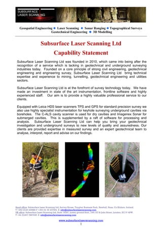
Equipped with Leica HDS laser scanners TPS and GPS for standard precision survey we
also use highly specialist instrumentation for keyhole surveying underground cavities via
boreholes. The C-ALS cavity scanner is used for dry cavities and Imagenex Sonar for
submerged cavities. This is supplemented by a raft of software for processing and
analysis. Subsurface Laser Scanning Ltd can help you bring your geotechnical
investigation and underground surveys to new levels of quality and assuredness. Our
clients are provided expertise in measured survey and an expert geotechnical team to
analyse, interpret, report and advise on our findings.
Head office: Subsurface Laser Scanning Ltd, Survey House, Tougher Business Park, Newhall, Naas, Co Kildare, Ireland.
T +353 (0)45 435880 F +353 (0) 45 437594. E: info@subsurfacelaserscanning.com
UK office: Subsurface Laser Scanning Ltd, Suite 16297, Lower ground floor, 145-157 St John Street, London, EC1V 4PW.
T +44 (0)207 7887928 E: info@subsurfacelaserscanning.com
www.subsurfacelaserscanning.com
1
2. Geospatial Engineering Laser Scanning Sonar Ranging Topographical Surveys
Geotechnical Engineering 3D Modelling
Professional Services
Subsurface Laser Scanning Ltd is the first geospatial and geotechnical engineering
company in Ireland to purchase the MDL Cavity Auto Laser Scanning System. We provide
a global consultancy service based from our offices in Ireland and the U.K.
Our staff have years of experience in precise measurement with terrestrial laser scanners,
geophysics and geotechnical engineering. Our aim is to provide an accurate
measurement service for previously unexplored and inaccessible locations. We will
analyze and interpret the data and advise you on the results.
Our services include:
Laser scanning
Sonar scanning
Measurement of abandoned mine workings
Measurement of underground voids via borehole
Utility chamber condition surveys
Stope and ore pass surveys
Karst void surveys
Geotechnical interpretation and reports
Ground penetrating radar
Determine pipe sizes and runs without entering confined spaces.
Structural monitoring
Full tunnel & shaft as-built surveys
Cavities behind tunnel lining surveyed
Measurement of stone bridge structure voids
Measurement of underground tanks – oil, gas, septic, interceptors
Measurement of inaccessible basements, cellars, hidden rooms
Measurement of inaccessible attics, lofts and large wall cavities
Geo-referenced topographic, structural & building surveying
Complete above and below ground data capture for comparison
As-constructed surveys
3d modelling and visualisation
Fly-through and walk-through movies
Head office: Subsurface Laser Scanning Ltd, Survey House, Tougher Business Park, Newhall, Naas, Co Kildare, Ireland.
T +353 (0)45 435880 F +353 (0) 45 437594. E: info@subsurfacelaserscanning.com
UK office: Subsurface Laser Scanning Ltd, Suite 16297, Lower ground floor, 145-157 St John Street, London, EC1V 4PW.
T +44 (0)207 7887928 E: info@subsurfacelaserscanning.com
www.subsurfacelaserscanning.com
2
3. Geospatial Engineering Laser Scanning Sonar Ranging Topographical Surveys
Geotechnical Engineering 3D Modelling
Profile of Mark Hudson FCInstCES MRICS ASCS ACIArb MIIS, Managing Director
32 years professional geospatial engineering experience on major civil
engineering and mining projects around the world.
Chief Surveyor on Dublin Port Tunnel & LUAS Light Rail Project.
Chief Circuit Engineering Surveyor for Formula One Administration (FOA & FIA)
on existing & proposed Grand Prix Circuits around the world.
Senior Surveyor on Jubilee Line Extension for London Underground.
Senior Surveyor on Channel Tunnel for Trans-Manche Link, Tarmac
Construction.
Ten years working for British Coal as a senior mining surveyor involved with
several collieries & major projects.
Mark is currently the vice chairman of the Institution of Civil Engineering
Surveyors International Affairs committee and a Fellow member of ICES Council
of Management.
Mark is a Chartered Surveyor with the RICS and SCS, an Associate member of
the Chartered Institute of Arbitrators & also a member of the Irish Institution of
Surveyors. Mark acts as expert witness on global litigation and arbitration cases.
Profile of Enda Nolan BSc MICE MIEI, Director
25 years experience in the construction industry working on a variety of railway,
civil & building projects, his experience has been gained in the UK, Ireland and
Spain.
Project management roles on major civil & railway infrastructure projects
including: Jubilee Line Extension and Docklands Light Rail Projects for London
Underground. Construction of Tower Block, Canary Wharf London.
Supervision and management role for LUAS Light Rail Project, Dublin.
Management role for Du Pont on a major power station construction project in
Northern Spain.
Enda is an active member of ICES, ICE & Engineers Ireland.
Liam Murphy Dip. Geo-Surveying MIS, Senior Laser Scanning Surveyor
Liam has 12 years of experience in multi-disciplinary surveying roles in Ireland
and the U.K. these include Project Manager, Laser Scanning Manager and
CAD manager
His primary role within Subsurface Laser Scanning is the management of our
surveying and laser scanning teams.
He has vast experience in laser scanning and as a Survey Project Manager,
over the years he has worked on projects ranging from industrial and domestic
infrastructure to private development and cultural heritage.
Liam has a passion for new technology and is continually seeking to add new
skills to broaden his knowledge base.
Head office: Subsurface Laser Scanning Ltd, Survey House, Tougher Business Park, Newhall, Naas, Co Kildare, Ireland.
T +353 (0)45 435880 F +353 (0) 45 437594. E: info@subsurfacelaserscanning.com
UK office: Subsurface Laser Scanning Ltd, Suite 16297, Lower ground floor, 145-157 St John Street, London, EC1V 4PW.
T +44 (0)207 7887928 E: info@subsurfacelaserscanning.com
www.subsurfacelaserscanning.com
3
4. Geospatial Engineering Laser Scanning Sonar Ranging Topographical Surveys
Geotechnical Engineering 3D Modelling
Partnerships
Coastway
Founded in 1999, Coastway is the largest chartered geospatial engineering survey
company in Ireland. Built on the core principle of a strong civil engineering and
engineering survey background they have become one of the most progressive and multi-
disciplined companies in the construction, civil engineering, tunnelling, mining and
architectural sectors. They provide professional services on a global platform.
AGEC
Founded in 2001, Applied Geotechnical Engineering Consultants was established to
provide specialist geotechnical consultancy and engineering advice to the engineering
industry. AGEC has worked throughout Europe on a wide range of projects incorporating
all areas of geotechnical engineering consultancy.
Clients (Selected)
Coal Authority
Network Rail
Tarmac
White Young Green
Donaldson & Associates
Atkins Global
T&L Excavations
Memberships and Affiliations
Subsurface Laser Scanning Ltd senior are professional members of the Chartered
Institution of Civil Engineering Surveyors, Royal Institution of Chartered Surveyors, Society
of Chartered Surveyors, Chartered Institute of Arbitrators, Institute of Civil Engineers,
Engineers Ireland, Irish Institute of Surveyors, British Tunnelling Society, Irish Mines &
Quarries Society, BGA and The Geological Society.
Subsurface Laser Scanning Ltd staff is required to maintain a professional ethos across all
divisions of the company. All Subsurface Laser Scanning staff has considerable
experience in their respective fields and are encouraged to undergo additional training at
every opportunity to ensure a continual development of skills both individually and as a
group. We have sufficient resources to cope with any survey no matter how large or small.
We pride ourselves on our ability to provide a friendly, personal and professional service at
all times.
Head office: Subsurface Laser Scanning Ltd, Survey House, Tougher Business Park, Newhall, Naas, Co Kildare, Ireland.
T +353 (0)45 435880 F +353 (0) 45 437594. E: info@subsurfacelaserscanning.com
UK office: Subsurface Laser Scanning Ltd, Suite 16297, Lower ground floor, 145-157 St John Street, London, EC1V 4PW.
T +44 (0)207 7887928 E: info@subsurfacelaserscanning.com
www.subsurfacelaserscanning.com
4