SlideShare una empresa de Scribd logo
1 de 15
Air Attack IR+GIS Low cost – Easy to Use 1 Infrared turns on with the plane 2 Daily fire map...moving 3 Intelligence to the ground By: Mark Zaller  www.AerialFireTech.org
Moving-Map Topos ,[object Object],[object Object],[object Object],[object Object],[object Object],[object Object],[object Object],[object Object],[object Object]
GIS overlays 90 missions in 2010, lots of success ,[object Object],[object Object],[object Object],[object Object],[object Object],[object Object],[object Object]
Fire Perimeters ,[object Object],[object Object],[object Object],[object Object],[object Object]
S ide  L ooking  I nf R ared SLIR ,[object Object],[object Object],[object Object],[object Object],[object Object],[object Object],Request IR
Request IR
[object Object],[object Object],[object Object],[object Object],[object Object],[object Object],[object Object],[object Object],Moving Maps on SmartPhones & Pads
[object Object],[object Object],[object Object],[object Object],[object Object],[object Object],[object Object],[object Object],[object Object],[object Object],Tactical GIS  on SmartPhones & Pads  For Air & Ground Firefighters in 2011
Intervalometer Photos or HD Video ,[object Object],[object Object],[object Object],[object Object],[object Object],[object Object]
Live Video in 2011 ,[object Object],[object Object],[object Object],[object Object],[object Object],[object Object]
End By: Mark Zaller  www.AerialFireTech.org   [email_address]
[object Object],[object Object],[object Object]
Type 1+  Air Attack Planes ,[object Object],[object Object],[object Object],[object Object],[object Object],[object Object],[object Object],[object Object],[object Object],[object Object],[object Object]
Courtney Aviation standard extras ,[object Object],[object Object],[object Object],[object Object],[object Object],[object Object],[object Object],[object Object],[object Object],[object Object],[object Object],[object Object],[object Object],[object Object],[object Object],[object Object],[object Object],[object Object],[object Object]
Courtney Aviation  Type 1+ Fire Attack Aircraft ,[object Object],[object Object]

Más contenido relacionado

La actualidad más candente

Keeping a Sentinel Eye on the Volcanoes – from Space!
Keeping a Sentinel Eye on the Volcanoes – from Space!Keeping a Sentinel Eye on the Volcanoes – from Space!
Keeping a Sentinel Eye on the Volcanoes – from Space!Advanced-Concepts-Team
 
UAV/Drone survey and its methodology and applications
UAV/Drone survey and its methodology and applicationsUAV/Drone survey and its methodology and applications
UAV/Drone survey and its methodology and applicationsUpendra Oli
 
UAS Applications for Civil Engineering
UAS Applications for Civil EngineeringUAS Applications for Civil Engineering
UAS Applications for Civil EngineeringUAS Colorado
 
Dare to Change - Geographic Intelligence - 2002
Dare to Change - Geographic Intelligence - 2002Dare to Change - Geographic Intelligence - 2002
Dare to Change - Geographic Intelligence - 2002Robert (Bob) Williams
 
UAV MAPPING, LIDAR MAPPING, LAND AND MINING AND ENGINEERING SURVEY - TES
UAV MAPPING, LIDAR MAPPING, LAND AND MINING AND ENGINEERING SURVEY - TESUAV MAPPING, LIDAR MAPPING, LAND AND MINING AND ENGINEERING SURVEY - TES
UAV MAPPING, LIDAR MAPPING, LAND AND MINING AND ENGINEERING SURVEY - TESBrett Johnson
 
Unmanned Aerial Systems for Precision Mapping
Unmanned Aerial Systems for Precision MappingUnmanned Aerial Systems for Precision Mapping
Unmanned Aerial Systems for Precision MappingUAS Colorado
 
TechBrief_LIDARvsUAV_050416_FNL
TechBrief_LIDARvsUAV_050416_FNLTechBrief_LIDARvsUAV_050416_FNL
TechBrief_LIDARvsUAV_050416_FNLdkinpdx
 
Unmanned Aerial Systems (UAS) Data Quality and Accuracy Realities
Unmanned Aerial Systems (UAS) Data Quality and Accuracy RealitiesUnmanned Aerial Systems (UAS) Data Quality and Accuracy Realities
Unmanned Aerial Systems (UAS) Data Quality and Accuracy RealitiesUAS Colorado
 
WE4.L09 - RECENT ADVANCES IN THE DEVELOPMENT OF THE OPEN SOURCE TOOLBOX FOR P...
WE4.L09 - RECENT ADVANCES IN THE DEVELOPMENT OF THE OPEN SOURCE TOOLBOX FOR P...WE4.L09 - RECENT ADVANCES IN THE DEVELOPMENT OF THE OPEN SOURCE TOOLBOX FOR P...
WE4.L09 - RECENT ADVANCES IN THE DEVELOPMENT OF THE OPEN SOURCE TOOLBOX FOR P...grssieee
 
DISPATCH Situational Awareness Software
DISPATCH Situational Awareness SoftwareDISPATCH Situational Awareness Software
DISPATCH Situational Awareness Softwareguestf48423
 
Multi Limn Leica Hds Conference 2009
Multi Limn   Leica Hds Conference 2009Multi Limn   Leica Hds Conference 2009
Multi Limn Leica Hds Conference 2009timbeach
 

La actualidad más candente (17)

UAVs: Understanding Unmanned Aerial Systems (UAS) and Potential Applications
UAVs: Understanding Unmanned Aerial Systems (UAS) and Potential ApplicationsUAVs: Understanding Unmanned Aerial Systems (UAS) and Potential Applications
UAVs: Understanding Unmanned Aerial Systems (UAS) and Potential Applications
 
Keeping a Sentinel Eye on the Volcanoes – from Space!
Keeping a Sentinel Eye on the Volcanoes – from Space!Keeping a Sentinel Eye on the Volcanoes – from Space!
Keeping a Sentinel Eye on the Volcanoes – from Space!
 
UAV/Drone survey and its methodology and applications
UAV/Drone survey and its methodology and applicationsUAV/Drone survey and its methodology and applications
UAV/Drone survey and its methodology and applications
 
UAS Applications for Civil Engineering
UAS Applications for Civil EngineeringUAS Applications for Civil Engineering
UAS Applications for Civil Engineering
 
Dare to Change - Geographic Intelligence - 2002
Dare to Change - Geographic Intelligence - 2002Dare to Change - Geographic Intelligence - 2002
Dare to Change - Geographic Intelligence - 2002
 
EsriMF_senseFly_Gervaix
EsriMF_senseFly_GervaixEsriMF_senseFly_Gervaix
EsriMF_senseFly_Gervaix
 
UAV MAPPING, LIDAR MAPPING, LAND AND MINING AND ENGINEERING SURVEY - TES
UAV MAPPING, LIDAR MAPPING, LAND AND MINING AND ENGINEERING SURVEY - TESUAV MAPPING, LIDAR MAPPING, LAND AND MINING AND ENGINEERING SURVEY - TES
UAV MAPPING, LIDAR MAPPING, LAND AND MINING AND ENGINEERING SURVEY - TES
 
Unmanned Aerial Systems for Precision Mapping
Unmanned Aerial Systems for Precision MappingUnmanned Aerial Systems for Precision Mapping
Unmanned Aerial Systems for Precision Mapping
 
TechBrief_LIDARvsUAV_050416_FNL
TechBrief_LIDARvsUAV_050416_FNLTechBrief_LIDARvsUAV_050416_FNL
TechBrief_LIDARvsUAV_050416_FNL
 
Spec00389
Spec00389Spec00389
Spec00389
 
Unmanned Aerial Systems (UAS) Data Quality and Accuracy Realities
Unmanned Aerial Systems (UAS) Data Quality and Accuracy RealitiesUnmanned Aerial Systems (UAS) Data Quality and Accuracy Realities
Unmanned Aerial Systems (UAS) Data Quality and Accuracy Realities
 
WE4.L09 - RECENT ADVANCES IN THE DEVELOPMENT OF THE OPEN SOURCE TOOLBOX FOR P...
WE4.L09 - RECENT ADVANCES IN THE DEVELOPMENT OF THE OPEN SOURCE TOOLBOX FOR P...WE4.L09 - RECENT ADVANCES IN THE DEVELOPMENT OF THE OPEN SOURCE TOOLBOX FOR P...
WE4.L09 - RECENT ADVANCES IN THE DEVELOPMENT OF THE OPEN SOURCE TOOLBOX FOR P...
 
Caldwell uas
Caldwell uasCaldwell uas
Caldwell uas
 
Drones Usage in AEC
Drones Usage in AECDrones Usage in AEC
Drones Usage in AEC
 
Ugcs
UgcsUgcs
Ugcs
 
DISPATCH Situational Awareness Software
DISPATCH Situational Awareness SoftwareDISPATCH Situational Awareness Software
DISPATCH Situational Awareness Software
 
Multi Limn Leica Hds Conference 2009
Multi Limn   Leica Hds Conference 2009Multi Limn   Leica Hds Conference 2009
Multi Limn Leica Hds Conference 2009
 

Similar a Geo meetup

Utilizing drone in land development
Utilizing drone  in land developmentUtilizing drone  in land development
Utilizing drone in land developmentKosygin Leishangthem
 
Droning On! Navajo Nation _ Darling Geomatics
Droning On! Navajo Nation _ Darling GeomaticsDroning On! Navajo Nation _ Darling Geomatics
Droning On! Navajo Nation _ Darling GeomaticsKatinaJohnson11
 
Spy vs SPI: Hacking the Stratus ADS-B Transponder
  Spy vs SPI: Hacking the Stratus ADS-B Transponder  Spy vs SPI: Hacking the Stratus ADS-B Transponder
Spy vs SPI: Hacking the Stratus ADS-B TransponderMayank Dhiman
 
Swisstrack GPS - What Are The Various Types Of Tracking Devices
Swisstrack GPS - What Are The Various Types Of Tracking DevicesSwisstrack GPS - What Are The Various Types Of Tracking Devices
Swisstrack GPS - What Are The Various Types Of Tracking DevicesSwisstrack GPS Erfahrungen
 
Frank van diggelen keynote, android gnss measurements update
Frank van diggelen keynote, android gnss measurements updateFrank van diggelen keynote, android gnss measurements update
Frank van diggelen keynote, android gnss measurements updateThe European GNSS Agency (GSA)
 
202209 QSO Today Virtual Ham Introduction to Software Defined Radio with emph...
202209 QSO Today Virtual Ham Introduction to Software Defined Radio with emph...202209 QSO Today Virtual Ham Introduction to Software Defined Radio with emph...
202209 QSO Today Virtual Ham Introduction to Software Defined Radio with emph...dhorvath
 
New Sensors for the Sensor Web
New Sensors for the Sensor WebNew Sensors for the Sensor Web
New Sensors for the Sensor WebTheodor Foerster
 
1st Technical Meeting - WP2
1st Technical Meeting - WP21st Technical Meeting - WP2
1st Technical Meeting - WP2SLOPE Project
 
TT Product Guide small
TT Product Guide smallTT Product Guide small
TT Product Guide smallShane Post
 
iPad pilot proficiency check: How to fly like a pro with your iPad
iPad pilot proficiency check: How to fly like a pro with your iPadiPad pilot proficiency check: How to fly like a pro with your iPad
iPad pilot proficiency check: How to fly like a pro with your iPadSporty's Pilot Shop
 
Aemp-14 use with rtk gps system
Aemp-14  use with rtk gps systemAemp-14  use with rtk gps system
Aemp-14 use with rtk gps systemLandviser LLC
 
FME User Stories from Around the World
FME User Stories from Around the WorldFME User Stories from Around the World
FME User Stories from Around the WorldSafe Software
 
FME Around the World (FME Trek Part 1): Ken Bragg - Safe Software FME World T...
FME Around the World (FME Trek Part 1): Ken Bragg - Safe Software FME World T...FME Around the World (FME Trek Part 1): Ken Bragg - Safe Software FME World T...
FME Around the World (FME Trek Part 1): Ken Bragg - Safe Software FME World T...IMGS
 

Similar a Geo meetup (20)

Utilizing drone in land development
Utilizing drone  in land developmentUtilizing drone  in land development
Utilizing drone in land development
 
Droning On! Navajo Nation _ Darling Geomatics
Droning On! Navajo Nation _ Darling GeomaticsDroning On! Navajo Nation _ Darling Geomatics
Droning On! Navajo Nation _ Darling Geomatics
 
Spy vs SPI: Hacking the Stratus ADS-B Transponder
  Spy vs SPI: Hacking the Stratus ADS-B Transponder  Spy vs SPI: Hacking the Stratus ADS-B Transponder
Spy vs SPI: Hacking the Stratus ADS-B Transponder
 
Swisstrack GPS - What Are The Various Types Of Tracking Devices
Swisstrack GPS - What Are The Various Types Of Tracking DevicesSwisstrack GPS - What Are The Various Types Of Tracking Devices
Swisstrack GPS - What Are The Various Types Of Tracking Devices
 
Frank van diggelen keynote, android gnss measurements update
Frank van diggelen keynote, android gnss measurements updateFrank van diggelen keynote, android gnss measurements update
Frank van diggelen keynote, android gnss measurements update
 
Mobile Options for ArcGIS – Selecting Your Solution
Mobile Options for ArcGIS – Selecting Your SolutionMobile Options for ArcGIS – Selecting Your Solution
Mobile Options for ArcGIS – Selecting Your Solution
 
GPS Vehicle Tracking Technology
GPS Vehicle Tracking Technology GPS Vehicle Tracking Technology
GPS Vehicle Tracking Technology
 
202209 QSO Today Virtual Ham Introduction to Software Defined Radio with emph...
202209 QSO Today Virtual Ham Introduction to Software Defined Radio with emph...202209 QSO Today Virtual Ham Introduction to Software Defined Radio with emph...
202209 QSO Today Virtual Ham Introduction to Software Defined Radio with emph...
 
GPS
GPS GPS
GPS
 
New Sensors for the Sensor Web
New Sensors for the Sensor WebNew Sensors for the Sensor Web
New Sensors for the Sensor Web
 
1st Technical Meeting - WP2
1st Technical Meeting - WP21st Technical Meeting - WP2
1st Technical Meeting - WP2
 
Ampio Smart Geolocation Drones
Ampio Smart Geolocation DronesAmpio Smart Geolocation Drones
Ampio Smart Geolocation Drones
 
LinkedinResume033015
LinkedinResume033015LinkedinResume033015
LinkedinResume033015
 
TT Product Guide small
TT Product Guide smallTT Product Guide small
TT Product Guide small
 
iPad pilot proficiency check: How to fly like a pro with your iPad
iPad pilot proficiency check: How to fly like a pro with your iPadiPad pilot proficiency check: How to fly like a pro with your iPad
iPad pilot proficiency check: How to fly like a pro with your iPad
 
Aemp-14 use with rtk gps system
Aemp-14  use with rtk gps systemAemp-14  use with rtk gps system
Aemp-14 use with rtk gps system
 
FME User Stories from Around the World
FME User Stories from Around the WorldFME User Stories from Around the World
FME User Stories from Around the World
 
FME Around the World (FME Trek Part 1): Ken Bragg - Safe Software FME World T...
FME Around the World (FME Trek Part 1): Ken Bragg - Safe Software FME World T...FME Around the World (FME Trek Part 1): Ken Bragg - Safe Software FME World T...
FME Around the World (FME Trek Part 1): Ken Bragg - Safe Software FME World T...
 
drone
dronedrone
drone
 
Aerial Services, Inc
Aerial Services, IncAerial Services, Inc
Aerial Services, Inc
 

Geo meetup

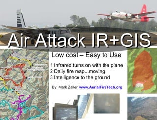
  • 1. Air Attack IR+GIS Low cost – Easy to Use 1 Infrared turns on with the plane 2 Daily fire map...moving 3 Intelligence to the ground By: Mark Zaller www.AerialFireTech.org
  • 2.
  • 3.
  • 4.
  • 5.
  • 7.
  • 8.
  • 9.
  • 10.
  • 11. End By: Mark Zaller www.AerialFireTech.org [email_address]
  • 12.
  • 13.
  • 14.
  • 15.