1. TERRESTRIAL MEASUREMENT OF RIVER CROSS-SECTION UPPER NISHAVA
RIVER BASIN
Terrestrial measurement in Republic of Bulgaria
Geodesic shooting of the cross sections of Nishava River in the part Godech Town –
Tuden Village
The object, subject of the current geodesic shooting, is located in Western Bulgaria
and is part of the territory of Godech Town and Tuden Village, Municipality of
Godech. Nishava River flows through the agricultural and urban lands of Godech
Town and Tuden Village. The shooting of the profiles along the river flow and the
river coasts of Nishava River is linearly long 9.3 km. The river coasts are eroded and
overgrown with bushes and partially trees. Generally, this river part is almost straight
but with numerous meanders along the river flow and varying slopes, which goes
down in direction from Godech Town towards Tuden Village.
The shooting was executed in Coordination System 1970 and Baltic Height System.
As a shooting basis are used spots of the RGO and TT39, TT2477 and TT1802,
available on spot during the shooting. For determination of the spots of the RGO are
used cinematic measurements in real time – RTK with differential corrections. Local
transformation parameters are derived for the area, and by them the coordinates of
the spots from RGO in Coordination System 1970 and the elevations in the Baltic
Height System were received.
During the geodesic shooting of the territories of the river flow and the river coasts
was used the method of the profiles, perpendicular to the river flow. The cross-
sections were measured as for a beginning was chosen the section one kilometer
above the urbanized area of Godech Town, above the bridge of Nishava at Ginska
River, and the final (end) section was measured about five hundred meters after the
urbanized area of Tuden Village. The distance between the single sections is about
500 m. The location of the spots of each section was determined by angle-length
geodesic measurements. 17 cross-sections in total were measured of Nishava River
in the section Godech Town – Tuden Village.
All hydro-technical equipment along the river was shot. These equipment involves: 6
bridges, thresholds of the rivers, retaining walls and fortifications of the shores of
Nishava River, built in the flow at the central urban part of Godech Town, between
two of the bridges.
The measurements for the determination of the coordinates for 37 spots of the
RGO were done by Global Positioning System (GPS). Two-frequency receptors
Topcon Hayper+ were used. The exact spots were determined in coordination
systems 1970 and Baltic Height System. A register of the coordinates of all spots is
applied. The measurements of the detailed spots are done by total station TOPCON
GPT 3005N and total station TOPCON GTS 7005 and were processed by
programming product for calculation of polar picture TPLAN. The data from the
measurements and its procession are digitally presented and burned on a CD and
graphically resented by printed bodies – 3 forders
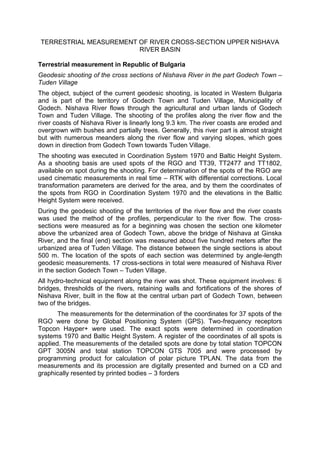
2. Scheme 1. Situational analysis of Nishava River from profile 1 to profile 23
Pictures 1, 2, 3, 4: Bridges of Nishava river on Bulgarian territory
Terrestrial measurement in Republic of Serbia
For cadastral municipalities in which the recording is made, used and maintained
survey, which was conducted aerial method of Gauss - Kruger projection, and to
sedamdeseth during the last century and at the same shall record the change - ie
mapping. Maintenance of measurement, monitoring state compliance with the state
of Teran in cadastral work and the original plan.
Recording Profile river at the Municipality of Dimitrovgrad was performed kinematic
GPS (Global Positioning System) method of processing data in real time (RTK) under
the Regulation for the application of global positioning system technology in the
survey property (Official Gazette of the Republic of Serbia no. 69/2002). GPS
3. receivers were used during filming are: "Topcon Legacy E" and "Topcon HiPer
GGD."
Start recording cross sections directly from the border with the Republic of Bulgaria
(profile # 1), and the final profile is the ultimate point downstream river at the border
municipality of Pirot and Dimitrovgrad (Profile br.48 ). In the area of the territory of the
Municipality of Dimitrovgrad on the river Nišava snimnjeno and 7 bridges, retaining
walls and the coastal fortifications of the same.
Table 1. Characteristics of profiles 1 and 2
Table 2. Characteristics of Bridge 1
5. Pictures 5, 6, 7, 8, 9, 10: Bridges of Nishava River on Serbian territory
Cheme 3. Profile of a bridge with codes
Nishava river is partially regulated in the town of Dimitrovgrad and the rest is natural,
partially the river banks are covered by crashed stones. The weather conditions
during the recording of the profiles were favourable. The vegetation in Nishava
riverbed was in a stage of growth, so it had to be cut in some parts in order to
measure the riverbed. Geodesic measurement of the cross section of the bridges
were executed in analogue and digital format and therefore they can be used in
further proceedings.