Euclid's Green Creek Ravine Preserve
•Descargar como PPTX, PDF•
1 recomendación•910 vistas

The document proposes the Green Creek Ravine Preserve, which would protect 6,700 linear feet of Green Creek and create an 8,000 linear foot recreation trail through 19 acres of forested ravines. The preserve would be a collaboration between Euclid, Cleveland, South Euclid, and Cuyahoga County Metroparks to showcase the creek, historic bluestone quarries, and connect to the Euclid Creek Reservation. The proposed budget is $85,800 with $19,800 matched by Euclid City funds and services.

Recomendados
Recomendados
Más contenido relacionado
Similar a Euclid's Green Creek Ravine Preserve
Similar a Euclid's Green Creek Ravine Preserve (20)
Más de Bluestone Heights
Más de Bluestone Heights (20)
Último
Último (20)
Euclid's Green Creek Ravine Preserve
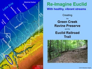
- 1. Gilchrist Harbor With healthy, vibrant streams Creating the Green Creek Ravine Preserve and the Euclid Railroad Trail Google Earth USGS LiDAR railsandtrails.com © 2013 Bluestone Heights
- 2. Gilchrist Harbor With healthy, vibrant streams Creating the Green Creek Ravine Preserve and the Euclid Railroad Trail Among our escarpment ravines, Green Creek stands out as a test case for creating a Portage Escarpment Ravine Preserve. Google Earth USGS LiDAR railsandtrails.com © 2013 Bluestone Heights
- 3. Green Creek overview Grovewood Collinwood Google Earth USGS LiDAR railsandtrails.com Green Creek length: 6,400 yd (3.63 mi) © 2013 Bluestone Heights
- 4. Green Creek overview Grovewood Collinwood Source: N of Glenridge & Green Roads On top of the Euclid bluestone Google Earth USGS LiDAR railsandtrails.com Green Creek length: 6,400 yd (3.63 mi) © 2013 Bluestone Heights
- 5. Green Creek overview Grovewood Collinwood Flows NW across the bluestone terrace Source: N of Glenridge & Green Roads On top of the Euclid bluestone Google Earth USGS LiDAR railsandtrails.com Green Creek length: 6,400 yd (3.63 mi) © 2013 Bluestone Heights
- 6. Green Creek overview Grovewood Collinwood Descends the escarpment face through the Euclid Moraine Flows NW across the bluestone terrace Source: N of Glenridge & Green Roads On top of the Euclid bluestone Google Earth USGS LiDAR railsandtrails.com Green Creek length: 6,400 yd (3.63 mi) © 2013 Bluestone Heights
- 7. Green Creek overview Grovewood Collinwood Flows NW across the St. Clair Terrace Descends the escarpment face through the Euclid Moraine Flows NW across the bluestone terrace Source: N of Glenridge & Green Roads On top of the Euclid bluestone Google Earth USGS LiDAR railsandtrails.com Green Creek length: 6,400 yd (3.63 mi) © 2013 Bluestone Heights
- 8. Mouth: E 156th, W of Euclid Beach Park Green Creek overview Grovewood Collinwood Flows NW across the St. Clair Terrace Descends the escarpment face through the Euclid Moraine Flows NW across the bluestone terrace Source: N of Glenridge & Green Roads On top of the Euclid bluestone Google Earth USGS LiDAR railsandtrails.com Green Creek length: 6,400 yd (3.63 mi) © 2013 Bluestone Heights
- 9. Green Creek Ravine Preserve organization City of Euclid in coordination with the cities of Cleveland and South Euclid, and with Cuyahoga County Metroparks Google Earth USGS LiDAR railsandtrails.com © 2013 Bluestone Heights
- 10. Green Creek Ravine Preserve organization City of Euclid in coordination with the cities of Cleveland and South Euclid, and with Cuyahoga County Metroparks To implement a new section of the County’s East Side Greenway plan Google Earth USGS LiDAR railsandtrails.com © 2013 Bluestone Heights
- 11. Green Creek Ravine Preserve organization City of Euclid in coordination with the cities of Cleveland and South Euclid, and with Cuyahoga County Metroparks To implement a new section of the County’s East Side Greenway plan To protect a significant riparian corridor Google Earth USGS LiDAR railsandtrails.com © 2013 Bluestone Heights
- 12. Green Creek Ravine Preserve organization City of Euclid in coordination with the cities of Cleveland and South Euclid, and with Cuyahoga County Metroparks To implement a new section of the County’s East Side Greenway plan To protect a significant riparian corridor To establish public access for a recreational trail to connect the Metroparks Euclid Creek Reservation. Google Earth USGS LiDAR railsandtrails.com © 2013 Bluestone Heights
- 13. Green Creek Ravine Preserve organization City of Euclid in coordination with the cities of Cleveland and South Euclid, and with Cuyahoga County Metroparks To implement a new section of the County’s East Side Greenway plan To protect a significant riparian corridor To establish public access for a recreational trail to connect the Metroparks Euclid Creek Reservation. Proposed Budget (land acquisition, implementation and design, construction and contingency) • $85,800.00 Google Earth USGS LiDAR railsandtrails.com © 2013 Bluestone Heights
- 14. Green Creek Ravine Preserve organization City of Euclid in coordination with the cities of Cleveland and South Euclid, and with Cuyahoga County Metroparks To implement a new section of the County’s East Side Greenway plan To protect a significant riparian corridor To establish public access for a recreational trail to connect the Metroparks Euclid Creek Reservation. Proposed Budget (land acquisition, implementation and design, construction and contingency) • $85,800.00 Google Earth USGS LiDAR railsandtrails.com City of Euclid • 30% match of $19,800.00 • Funds and in kind services © 2013 Bluestone Heights
- 15. Green Creek Ravine Preserve goals To protect 6,700 linear feet of riparian corridor Google Earth USGS LiDAR railsandtrails.com © 2013 Bluestone Heights
- 16. Green Creek Ravine Preserve goals To protect 6,700 linear feet of riparian corridor To create 8,000 linear feet of recreation trail Google Earth USGS LiDAR railsandtrails.com © 2013 Bluestone Heights
- 17. Green Creek Ravine Preserve goals To protect 6,700 linear feet of riparian corridor To create 8,000 linear feet of recreation trail To give public access to 19 acres of forested ravine terrain Google Earth USGS LiDAR railsandtrails.com © 2013 Bluestone Heights
- 18. Green Creek Ravine Preserve goals To protect 6,700 linear feet of riparian corridor To create 8,000 linear feet of recreation trail To give public access to 19 acres of forested ravine terrain To provide for interpretive displays related to historic bluestone quarries Google Earth USGS LiDAR railsandtrails.com © 2013 Bluestone Heights
- 19. Green Creek Ravine Preserve goals To protect 6,700 linear feet of riparian corridor To create 8,000 linear feet of recreation trail To give public access to 19 acres of forested ravine terrain To provide for interpretive displays related to historic bluestone quarries To showcase existing storm-water controls Google Earth USGS LiDAR railsandtrails.com © 2013 Bluestone Heights
- 20. Green Creek Ravine Preserve goals To protect 6,700 linear feet of riparian corridor To create 8,000 linear feet of recreation trail To give public access to 19 acres of forested ravine terrain To provide for interpretive displays related to historic bluestone quarries To showcase existing storm-water controls Google Earth USGS LiDAR railsandtrails.com To highlight long term human impact on nature © 2013 Bluestone Heights
- 21. Green Creek Ravine Preserve details Green Creek streambed Euclid Railroad rail bed Google Earth USGS LiDAR railsandtrails.com © 2013 Bluestone Heights
- 22. With healthy, vibrant streams In conclusion: Escarpment Ravines + Vacant parcels = Portage Escarpment Ravine Preserves The Green Creek Ravine Preserve is the first building block in our must-have series of Portage Escarpment Ravine Preserves With it, we may begin to: Restore places & eco-functions Enhance cultural richness Prepare for a better future © 2013 Bluestone Heights