

Recomendados
Recomendados
Más contenido relacionado
Destacado
Destacado (6)
Similar a Goswami_AGU2008_Spectral_Library_Poster
Similar a Goswami_AGU2008_Spectral_Library_Poster (20)
Goswami_AGU2008_Spectral_Library_Poster
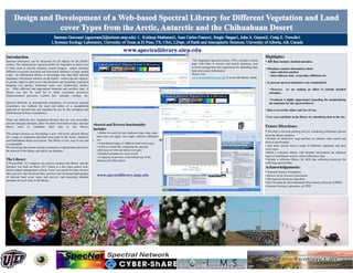
- 1. Introduction Highlights: Spectral reflectance can be measured for all objects on the Earth’s The Vegetation Spectral Library (VSL) includes a home • All data includes detailed metadata surface. The characteristic spectral profile for vegetation or land cover page with links to browse and search functions, user Section Title is often used to classify remotely sensed imagery and/or calculate account management and registration for uploading data, Section text here. Section text here. Section text here. Section • Metadata contains information about different ecosystem structural and functional attributes at large spatial help and contact information. text here. Section text here. Section text here. Section text • data collection method scales. An information library or knowledge base that links spectral Please visit: here. Section text here. • data collector, data ownership, affiliation etc. signatures with known surfaces on the Earth’s surface has the capacity www.spectrallibrary.utep.edu to access the library online. to greatly improve land cover classifications and including vegetation • At present spectral metadata is not standardized mapping (via species, functional types, etc), biodiversity studies, etc. With sufficient and appropriate metadata and ancillary data. A • However, we are making an effort to include detailed library can also be used for to study ecosystem processes, metadata . biogeochemical processes (carbon flux, nitrogen cycling), etc. • Feedback is highly appreciated regarding the standardizing Spectral Network, an international community of ecosystem spectral the metadata for the spectral library. researchers, has outlined the need and utility of a standardized approach to spectral data and metadata for use by the ecological and • Data is accessible online and free of cost. Earth System Science communities. • User can contribute to the library by submitting data to the site. There are relatively few vegetation libraries that are web accessible, provide adequate metadata, allow for direct download of data, and also •Search and Browse functionality Future Directions: allows users to contribute their data to the library. includes • Ability to search by site, landcover type, date, time, • Develop a real time plotting tool for visualizing reflectance spectra This project focuses on developing a new web-based spectral library time zone, sun angle, view angle, collector, affiliation from the library database. for a range of vegetation and land cover types in the Arctic, Antarctic • Include an interactive map interface to enhance data search and and Chihuahuan desert ecosystems. The library is free, easy to use and •. etc. browse functionality. is expandable. • A thumbnail image of different land cover types • A link to a Data file containing the spectral • Add more spectra from a range of different vegetation and land We encourage the remote sensing community to upload data relevant to reflectance of relevant land cover types cover types. the mission of the library and add to our database. • Detailed metadata for each record • Build a reference library with detailed information for different • A capacity to preview or download any of the types of instruments used to collect reflectance data. The Library features described above. • Include a reference library for field data collection protocols for A PostgreSQL v.8.1 database was used to construct the library and the collecting spectral data. interface was built on Plone 3.0.7 which is a free open source web- Acknowledgements: based content management system. Users can search for data, browse data, preview and download data, preview and download photographs • National Science Foundation of relevant land cover types and preview and download detailed • Barrow Arctic Science Consortium metadata for each entry in the library. • The Spectral Network (SpecNet) •The Circumarctic Environmental Observatories Network (CEON) • Systems Ecology Laboratory at UTEP
- 2. Issues & Questions – John Gamon • What is the URL? (missing from the poster). • Problematic text in red: What are “interpolations of ecosystem structure and functonal attributes”? Something missing from the phrase: “This study a new web-based spectral library” • Text in blue: how do we “encourage the remote sensing community to upload data relevant to the mission of the library and add to our database.”? Just how is this to be done? What is the URL, the portal & user interface, etc? • What are the links to SpecNet, NASA, Oak Ridge, GeoChronos and other efforts?