1. THE DYNAMIC-EARTH AND CONSEQUENCE
THEORIES
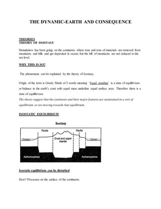
THEORY OF ISOSTASY
Denudation has been going on the continents where tons and tons of materials are removed from
mountains and hills and get deposited in ocean; but the hill of mountains are not reduced to the
sea level.
WHY THIS IS SO?
The phenomena can be explained by the theory of Isostasy.
Origin of the term is Greek; Made of 2 words meaning ‘Equal standing’ is a state of equilibrium
or balance in the earth’s crust with equal mass underline equal surface area. Therefore there is a
state of equilibrium.
The theory suggest that the continents and their major features are maintained in a sort of
equilibrium or are moving towards that equilibrium.
ISOSTATIC EQUILIBRIUM
Isostatic equilibrium can be disturbed
How? Processes on the surface of the continents.
2. 1) Denudation
-Weathering/mass wasting, transportation, and erosion.e.g removal of material which lower the
surface.
2) Deposition -Building up process (rising of the land)
3) Accumulation of ice masses and melting of ice masses.
For example
When denudation removes the material from mountains there is pressure released, uplift occurs
where the material is removed and there is no Isostatic balance.
If the material is deposited on the sea bed there is compression which result in sinking (vertical
movements) these vertical movements causes horizontal movements of simatic material from
there is compression has taken place to where there was pressure release
In such process a state of equilibrium is restored.
EFFECT OF DISTURBANCE AT SURFACE AND READJUSTMENT OF ISOSTATIC
EQUILIBRIUM
3. EFFECTS OF DISTURBANCE OF ISOSTATIC EQUILIBRIUM
1. Earth quakes- Earth movements (gradual)
2. Subsidence +uplift (submerged coast /raised beaches)
3. Faulting -Result to rift valleys or block mountains, lift blocks
4. Fold- Fold Mountains
5. Volcanic eruptions forming different volcanic feature (volcano)
6. Displacement of lithosphere leading to plate tectonic
Evidences of Isostatic movements
1. The depression of the crust in the northern part of America and Europe was due to the weight of
ice sheets of vast thickness during the ice age.
2. After the melting these ice sheets, the crust has been rising.
4. Slowly for example, there are numerous former beaches that occur around the coast of
Scandinavia. They now lie between 8m-30m above the present day beaches. These old beaches
have been raised because of the uplift of the land.
3. The continental shelf around Antarctica is covered with water to a depth of about 750m
compared with 180m around other continents.
4. The presence of Rias and Estuaries between the coast lands of Gambia and Sierra Leone.
5. The submergence of forests on the shores of Britain.
IMPORTANCE OF THE THEORY
1) It provides the knowledge on the dynamic state of the earth’s crust that is the earth’s crust is not
static but it is always dynamic as it tends to balance itself after some disturbances with the
influence of the gravitational force.
2) The analogy that the crust floats on the mantle, just like the iceberg floats on and the ocean or
sea water, is so crucial in the understanding of the theories of plate tectonics and continental
drift.
3) The theory also helps in deciphering (understanding) how different landforms were formed.
4) It also gives the basic for predicting the future of the crustal state at any particular place on the
earth’s surface.
5) It can also help human being in taking some precautions depending on the nature of the
phenomena that might have been observed in the course of time, like the occurrence of ice sheets
and melting of ice.
2 THEORY OF CONTINENTAL DRIFT
There are 7 continents
Origin of these continents
Propounders
- Francis Bacon (1620) Expanded earth
- F .B Taylor
- Alfred Wegener 1912.
5. According to his theory ,about 280 million years,the present day continents were united in a
single block called Pangaea and sorrounded by ocean called Panthalassa.He believed that
Pangaea was located near the South pole.Later Pangaea split into two (2)Super-continental i.e
Gondwanaland(south Pole) and Laurasia(along the equator in the northern hemisphere).
These two Super-Continents were separated by a narrow water body i.e Tethys sea.He assert that
Laurasia split to form present day N.America,Asia,Europe,and numerous landmasses found in
northern Hemisphere-Greenland,Iceland and United Kingdom.
Gondwanaland split to give present day Africa,S.America,Australia and Indian sub-
continent,Antarctica and other islands in the southern Hemisphere.
Drift:
Since that time the continents have been drifting apart to occupy their present positions. And the
drifting is a very slow one about 2cm per year. The drifting is still in progress.
Evidence to support Wegeners theory of Continental Drift
1. Structural evidence ( Jig saw fit)
If the continents were to be brought together it will form one single landmass called
Pangaea. Hence proves that all the continents come from one land mass. For example S.
America could fit into Africa, N. America into Europe, Antarctica, Australia, India and
Malagarasy formed in a single landmass with S. America.
2. Geological evidence :
Similar rock types in the coastal margin of the continents for example if you take the rocks of
west Africa coastal margin and those of Eastern coast Brazil coastal margin the rocks will be the
same (similar ) These rocks where one before the split. (Similar type, age, structure, formation)
3. Biological evidence :
The study of earlier life in sedimentary rocks. That reveals life similar fossils of different time
where found in different places. Similar animals, plants and e.g. .These fossils are found in all
continents hence prove that they all come from one landmass
4. Geomorphologic evidence:
Structure of mountains ( fold mountains) e.g. The Alps and Atlas have similar features and
where also formed under similar conditions, type of rocks the mountain case, structure,
alignment and were formed when Africa moved north wards ending up colliding
with the European continent. This gives evidence that the drifting movement took place.
5. Pale-climatic evidence:
6. The discovery of ancient is in the Congo basin where the climate is warm is used as evidence
that the Africa continent drifted from parts which were cold to the current warm parts. For
example, Africa has been shifting north wards from the south likewise coal deposit found
beneath Antarctic ice caps and Greenland show that they were deposit when the continents had
not drifted led to those places when the climate coast warm. This is because the organisms that
led to the formation of those deposits cannot east in areas where there is very low temp.
6. Paleo magnetism (palae-magnetic evidence).
This is the most conclusive proof of the continental drift which was done through pale magnetic
dating. When the rocks cooled they were magnetized in the same direction (magnetic North) but
pale magnetic dating shows that rocks older than 200,000 years ago from different parts of the
earth, have shifted their relative positions magnetic fields show new paths representing relative
migration of the earth’s materials
This is evidence that the continents have drifted or have been drifting.
7. Ocean floor spreading.
7. Weakness of Wegener / critiques of the theory
1) He did not explain how the movement has occurred / the continental drift processes.
2) He was not a geologist but meteorologist hence he was criticized to have involved in the field
where he was probably less informed.
3) Not all continents are able to fit exactly as argued in the jig-saw fit theory, but the theory does
not account for this aspect.
4) Other scientists argue that the plant remains might have been spread by aspects like wind,
blowing from one continent to another.
5) Wegner failed to explain the development of glacier in the hot arid Australia.
4.2 PLATE TECTONIC THEORY (Unifying theory)
It takes the combination of theory of theory of isostacy, continental drift and ocean floor
spreading.
According to this theory,the earth has an outer shell(lithosphere) made up of several rigid
piece called tectonic plates.
I) Geometrical part - The crust is made up of segment called plates, which are of various sizes,
Large and small plates. pacific, N. American, Nazca, S. American, Africa, Indian, Antarctica
plates
II) Moments- Movement of the plates. The plates are in motion. Either they are diverging or
converging cause of movement – Convectional currents from the interior of the earth’s especially
aesthnosphere.
The movements can cause plates to collide or slide past one another. The rate of motion is very
slow of the plates relative to one another 1cm to 2cm per year.
TYPES OF PLATE BOUNDARIES:
1) Divergent boundary - Is a boundary which is created when the plates are moving
away from each other. This normally occurs in the ocean, where there are mid-
oceanic ridges.
Example
- Mid Atlantic ridges
8. - Island Arcs ( volcanoes)
- Rift. valley Graben
2) Convergent boundary - Is boundary where by the plates are moving towards one
another
3) Neutral / trans current boundary- This occurs when plates are sliding past one another.
Normally occur on the Transform faults. (No uplift or submerge of the land (crust)
9. MECHANISMS OF THE PLATE MOVEMENTS AND THE PLATE BOUNDARIES:
Plates are either continental or oceanic.
Oceanic plates are simatic (denser).
Continental Plates are Sialic (light).
CONVERGENT PLATE BOUNDARY
i) Continental and continental - Both will go uplifted and result to folds and faults
ii) Oceanic and continental -The denser will down lift and lighter will uplift and may result
to volcanic eruption and subduction result to trenches for the denser plate.
iii) Oceanic and oceanic - Convergent boundary ( subduction result to trenches both will
move down)
Plate Tectonic Theory states that “The lithosphere is made up of rigid segments called
the plates and the plates are in constant state of motion relative to one another”
CAUSES OF MOVEMENTS:
I) Convectional current - During mantle convection some materials rise due to the influence
of radioactive heat generation and later moves laterally below the lithosphere. The lateral
movements
drag the lithosphere leading to the plate tectonic movements. On cooling the materials sink
down to the lower level of the mantle where they melt again due to the constant motion of the
plates
II )Upwelling of magma in the lines of weakness for example in the mid-oceanic ridges
where by the magma is pushed out of the surface through the weak lines of the crust, in order to
form a
new crust. This may result to the cause of movements
10. III) Isostatic adjustment - May cause slight movement when trying to create balance.
IV) Cooling and heating of the crustal rocks -Expansion and contraction of rocks. The heat
in the interior of the earth (mantle) causes rocks inside to expand and when the heat reduces, the
rocks
cool. This process causes the rocks to crack hence leads to the disturbance of the crust and
causes movements.
EFFECTS OF PLATE MOVEMENT:
Changes on the plate boundaries which are lines of weakness and on these boundaries, major
landforms of the earth’s surface are going to be formed.
a) Diverging plates
I) Oceanic
- Mid oceanic ridges
- Oceanic Islands
- Rifts e.g. Red sea
II)Continental
-Volcanic mountain
- Block mountains
-Rift valley
b) Convergent plate boundary- Collision may lead to subduction and uplift.
i) Oceanic - oceanic trends (Marianna trenches, Japan trenches )
ii) Oceanic and continental-Volcanic mountains on the coastal boundaries and also result into
trenches.
iii) ( Continental )- Formation of Fold Mountains. Himalayas ( Indian and Russian plate formed)
11. c) Neutral / Trans current boundary - There is neither uplift nor seduction. There is lateral
displacement of the plates. N. America, San Francisco - San Andrea’s faults displacement of
features of about 1000km.
The plate tectonic areas are areas of instabilities which results to earth quake, volcanoes.
The theory of plate tectonic can help to explain almost all of the landforms on the surface
of the earth.
I. Deep sea Trenches: A sea trench is a long deep valley along an ocean floor.they form along a
convergent destructive term of depth.the Mariana in the western Pacific with a depth of more
than 36000ft.
II.Mid Oceanic Ridge: It refer to a giant undersea mountain range made up mostly basalt.It may
be more than 80000km long and 1500 to 2500km wide and it may rise to 2.3km above the ocean
floor.The feature is associated with a divergent plate boundary.As plate diverge,magma rises
repeated and eventually cools to form the mid oceanic ridge.
Example: East Pacific as Nazea and Pacific diverges North Atlantic as North America diverges
the Eurasian.
III.Island Arcs:Sometimes basalt eruption along the ridge or near may build up volcanoes that
protrude above sea level to become Oceanic Island.They may vary in
size.Example:Iceland,Japan,Hawaiian is lands, Mauna Loa,Easter Islands near the East Pacific
ridge,west Indies.
IV. Magmatic Arc:It refers to island arcs at sea and belts of igneous activity on the edges of
continents such as batholiths in mountain belts. Example:Aleutian Island.cascade volcanoes of
the pacific North West,along Andes.
V. Mountain Belts:At a convergent collision boundary,the sea floor is denser and will be
subducted making the ocean thinner and narrower hence collision of the continents.Eventually
the oceanic lithosphere breaks off leaving the continental crumple to form mountain ranges.
The thick sequences of sedimentary rocks that had built upon both continental margins are
intensively.Example The Himalayas as India collided lided, Alps as African and Europe ,Atlas
in Northern Africa.In addition to that at a convergent destructive boundary,young mountain like
the Andes form due to the folding of the young sediments.
VI.Rifting and associated features:At a passive divergent plate boundary ,the continental crust is
stretched and thinned producing faulty landforms like the great East Africa Rift Valley.The faults
12. may be path associated volcanic landforms.This may explain the volcanic landforms in the rifted
areas of East Africa.
Due to thermal expansion emanating from rising mantle plume,it causes uplift of landscape.
VII.New Oceanic Crust:This is associated with a divergent plate margin where the would be gap
is filled with the up welled magma to form a new oceanic crust.
4.3 MATERIALS OF THE EARTH’S
CRUST
What is an element?
A substance which cannot be split into simple substances by physical or chemical means.
Elements are made up of atoms. Atoms are made up of protons which are positive (+ve) charges,
electron which have negative (-ve) charge and neutrons which do not have any charge
-Elements are about over 100 elements known so far
-About 90 elements exist naturally some elements exist naturally but they do not exist
themselves they combine to form a compound (some exist independently which others are
compound of more than one element.)
13. -Of the 90 element, 8 element are the most a bund and in the crystal rocks.
These are:
Element
1 .oxygen
2. Silicon
3. Aluminium
4. Iron
5. Calcium
6. Sodium
7. Potasium
8. Magnesium
What is a mineral?
-Is composed of atoms arranged in a specific order which is 3 dimensional (crystalline) in
structure.
OR
-Are naturally occurring inorganic substance made up of elements or compounds which is 3
dimensional (crystalline) in structure.
Properties of Minerals
14. - Definite shape (crystalline)
- Is inorganic (naturally occurring substance)
- Minerals must be solid
- Made up of element or compound
N.B: Only minerals which are inorganic are minerals. Coal is not a mineral because it is
not inorganic.
IDENTIFICATION OF MINERALS
In the field:
1) Its colour-Minerals have different colours
2) Luster -How a rock reflects the light. (Metallic luster they glitter and non-metallic luster are
dull)
3) Streak -Powder which is obtained by rubbing the rock with a harder substance
For example: Iron will remove a darker streak than the colour of the iron .But if it is not a non-
mineral, the streak will be lighter than the substance.
4) Cleavage -If break the rock it will split into definite shape (definite pattern) e.g. mica break
into sheet pattern.
5) Crystalline - In 3 dimensional
6) Specific gravity- All mineral have higher specific gravity than water. H2O is 1g/cm3
7) Hardness -Minerals differ in hardness obtained through scratch test; there is a soft test &
hardest test (Moh’s scale hardness; 10 minerals starting from softest of hardest.)
WHAT IS A ROCK?
15. - Is a more or less uniform mass made up of grains of one or more mineral which is found
naturally on the earth crust.
- Are aggregates of minerals.
ROCK CLASSIFICATION
They can be classified according to :-
(a)Mode of formation
(b)Geological Age
(c)Structure
A. ROCK CLASSIFICATION ACCORDING TO MODE OF FORMATION
According to mode of formation/origin , rock can be classified as Igneous, Sedimentary and
Metamorphic.
1. IGNEOUS ROCKS:
These are crustal rocks formed by cooling either within or outside of the earth’s crust. (Formed
by cooling and solidification of molten materials from the interior of the earth)molten materials
can solidify intrusively or extrusive (endogenically or exogenically)when molten material are
still within the earth crust they are referred as magma, and when reach the surface they are called
lava. Examples; basalt granite, Quartzite, Gabbro cools and solidifies to form volcanic rock
Igneous rock Is referred to as mother rock, due to the following reasons.
1) It is the rock from which other rock owes their origin. This means that other rocks are formed
after some forces have operated on the igneous rock. Such forces are like weathering process
which led to the formation of sedimentary rocks and metamorphic.
16. 2) It forms the base for soil formation (pedogenesis) whose minerals composition, structure,
texture and depth depend on the nature of the igneous rocks. E.g. soft igneous rocks, soil
becomes deep and if a rock is hard the soil shallow.
3) The igneous rocks constitute the large proportion of the earth crust i.e.: 99%
CLASSIFICATION OF IGNEOUS ROCKS
1.) Extrusive rocks (volcanic) :
These are formed when the molten materials (lava) solidifies on the surface.
These rocks have small crystals because they cool fast due to exposure. Examples include
Basalt, Andesite, rhyolite, obsidian and etc.
2.) Intrusive rocks-
These are formed when the molten magma solidifies within the earth crust. They can be
classified as hypabyssal igneous rocks, when they are formed near the earth’s surface and
plutonic igneous rocks when they are formed deep inside the crust.
Categories of intrusive igneous rocks
2(i) Hypabyssal igneous rocks-:
These are the rocks which are formed when magma cools and Solidifies inside but near the
surface of the earth. They have medium size and examples are like granophyres, Porphyries,
and dolerite. These can be exposed after erosion has taken place to form some rock masses like
lopoliths and laccoliths which are usually hypabyssal. Basalt also quartz.
2(ii) Plutonic igneous rocks:
These have solidified deep in the crust and they are seen on the surface only after being
exposed by prolonged erosion. Example granite, gabbro, pumice and peridotite.
17. CLASSIFICATION OF IGNEOUS ROCKS BY THEIR CHEMICAL COMPOSITION
Felsic (acidic)igneous rocks:
Consist great amount of silica and feldspar with very little or no iron or any other metallic
minerals examples are granite, granophyres, rhyolite, and obsidian. They are acidic in nature.
Mafic (basic) igneous rocks:
Consist of large amount of magnesium iron and other mineral like aluminium. They are basic in
nature because of presence of metallic minerals e.g. gabbro, basalt
Ultra-mafic(ultra basic):
Consist of very large amount of metallic minerals like iron, magnesium and a little amount of
silica less than 45% e.g. peridotite.
Intermediate Igneous rocks - With silica content between basic and acidic degree. That is, both
acidic and basic oxides are in equal proportions. E.g. Diorite, Andesite.
CHARACTERISTICS OF IGNEOUS ROCKS:
1) They are hard, they are semi precious.
2) They are formed by cooling and solidification of molten materials i.e. Magma or lava.
3) They differ in chemical composition depending on the amount of silica contained in them.
4) They are crystalline in nature (made of crystal)
5) They may undergo metamorphism to form metamorphic rocks.
18. 6) They may undergo weathering process and sedimentation to form sedimentary rocks.
7) They contain minerals like iron, magnesium etc.
8) They don’t have fossils; therefore they do not contain the remains of skeletons’ of animals.
Because they are made from the interior of the earth.
2.SEDIMENTARY ROCK:
Are rocks formed from sediments deposited either by water or by wind or by ice. These rocks are
formed by the process of the sedimentation. (Deposition of accumulation and lithification of
some weathered particles and other materials). The sediment were laid down in layers or strata,
one on top of the other and in time these layers turned into rocks as they became hardened by
compression. These are called stratified rock.
-The plane between two layers is called the bedding plane.
-The angle of the titled strata to the horizontals called the dip
All sedimentary rocks are non-crystalline and many contain fossils. Some sedimentary rocks are
formed in water .e.g. Inorganic-Sandstone and mud stone; Organic-Chalk, limestone and coral,
and peat and coal (formed in swamps). Some are formed on land e.g. boulder cay, moraines and
loess (all inorganic).
Those formed in water developed from inorganic sediments some sedimentary rocks are formed
chemically and not from sediments.
There are three (3) types of sedimentary rocks;
1) Mechanically formed;
19. These are the rocks which have been formed by compaction and these are also referred as
classic rocks because they consist of fragments of rocks and rocks materials. Examples; clay,
gravels and alluviums (all deposited by water), moraines, boulder clay and gravels (deposited by
ice), and loess (deposited by wind).
2) Organically formed;
These rocks have been formed by the accumulation, consolidation and cementation of the
remains of died organisms. They include calcareous rocks like limestone and chalks formed from
the shells and skeletons. Coral reefs are so common along the East African coast. These are also
carbonaceous rocks formed from plant and remains buried a thousand of years ago under heat
and the overlying pressure, the plant remains turned into rocks. Example Coal.
Also there are siliceous rocks formed as the result of the remains of organisms like
Diatoms and radiolarians, whose skeletons are rich in silica, Example diatomite rocks.
Example; Chalk and Coral (formed from animals), and peat, coal and lignite (formed from
Plants). Rocks formed from organic sediments which are plants and animals remains which
accumulate, compact and cement.
3) Chemically formed; these are the rocks which formed by chemical process. They include the
following:-
a) Carbonates. Like travertine found in the form of stalagmites and stalactites due to the
precipitation of calcium bicarbonate, trona due to the hydration of sodium carbonate solution
after the evaporation of water.
b) Sulphate. As the result of desiccation and evaporation. Rocks like gypsum, which are
hydrated calcium sulphate, may be formed as result of rapid evaporation.
c) Chlorides. Which include rocks salt is formed due to evaporation.
20. d) Silicates. Which include flint, sinter and cherty are formed due to the accumulation of silica
followed by its compaction.
e) Iron stones. Are formed when iron oxide is deposited under a water body and compressed.
Examples of such rocks include limonite and haematite (red ferric oxide).
MECHANICALLY
FORMED
ORGANICALLY
FORMED
CHEMICALLY
FORMED
Shale Lignite coal Gypsum
Mudstone Bituminous coal Rock salt
Siltstone Anthracite coal Potash
Grit Coral reef Flint
Limestone Trona
Chalk Ironstone
CHARACTERISTICS OF SEDIMENTARY ROCKS
1. They are stratified and young rock layers overlying the old rock layers.
2. They are non- crystalline.
3. They contain fossils as the result of the accumulation of skeletons and shells of once living
organisms.
4. They may undergo changes to form metamorphic rocks, when they are influenced by pressure
and or temperature.
5. They consist of some fragments, which were deposited and then cemented to form the rocks.
6. They are soft (not hard).
21. 3.METAMORPHIC ROCKS
These are rocks which are formed when one type of rock changes form after having been
subjected to either intense heat, pressure or both. Any rock may undergo changes to form
metamorphic rocks e.g.
Sedimentary rocks to metamorphic rocks are:-
1. Sandstone to Quartzite
2. Limestone to Marble
3. Coal to Graphite
4. Shale or Clay to Slate.
5. Mudstone to Slate.
Metamorphic to Metamorphic rocks
1. Slate to Schist
Igneous rock to metamorphic rock
1. Augite to hornblende
2. Granite to gneiss.
Causes of Metamorphism
1. Great heat -High temp. Acting on the existing rock. E.g. Bricks there from mud, also the
intrusive igneous rocks can change to metamorphism.
22. 2. Pressure- Rock can be compressed to form other rock resulting from earth movements.
3. Chemical reaction.
4. Pressure + Temperature can form sedimentary rocks to change to metamorphic.
Metamorphism The process of changing the rock from either Igneous, Sedimentary or
Metamorphic rock to metamorphic rock.
Types of Metamorphism
1) Contact metamorphism -Rock change by contact, e.g. Intrusive magma will affect other rock
and form metamorphic rocks Localized because it is not extensive it only affects the rocks which
surround it.
2) Regional/ Dynamic Metamorphism - Result from pressure of internal movement which will
compress the rocks to change their form. They cover a large area.
3) Thermal/dynamic Metamorphism - Combination of heat and pressure which can
combine and change the form of the rock.
TYPES OF IGNEOUS ROCKS
TYPE FORMED A
T
RATE OF
COOLIN
G
CRYSTALLIN
E NATURE
EXAMPLE
S
VOLCANIC The surface Fast Small Crystals Basalt
Rhyolite
Trachyte
Andesite
23. Shallow Medium Medium Quartz
HYPABYSSA
L
Depth size Crystals Porphyry
Dolerite
Great Slow Large Granite
PLUTONIC depth Crystals Syenite
Gabbro,
diorite
Diorite
TYPES OF METAMORPHIC ROCK
Original rock Metamorphic rock
Granite becomes Gneiss
Sandstone Quartzite
Clay Slate
Shale Schist
Limestone Marble
24. ROCK FORMING MINERALS
These are common minerals which make up large percentage of the rock of the earth’s crust.
These rocks are silicates.
1) Feldspar - Most abundant of all minerals in rocks. There are 2 varieties
i. Orthoclase feldspar of complex chemical formula KALSi3O8 a compound of Potassium,
Aluminum, and Silicate.
ii. Plagioclause feldspar which contains sodium or calcium instead of potassium as in
orthoclase.
: . you have NaALSi3O8 or CaAL2Si2O8 (plagioclase feldspar) e.g. Basic rock, basalt, gabbro
Feldspar have S.G (specific gravity) of 2.5g/cm3
25. 2. Quartz -Second most abundant
- Chemical formulate (SiO2) Silicon dioxide
- Hardest common mineral
- S.G 2.7
- Has no cleavage
- Used for making concrete glass and as a semi precious stone.
3. Mica. Can be composed of many elements .e.g. aluminum, silicon, oxygen, iron, magnesium,
hydrogen, or potassium.
-It is flat shiny rock most found in rocks like granite, gneiss or schist.
4. Carbonates: e.g. CaCo3 found in limestone and marble (Dolomite) Camg (co3)2
5. Horn blend: Common rock forming mineral dark crystalline mass associated with igneous
+
metamorphic rocks.
- composed on calcium, iron and magnesium silicate.
6) Magnetite: (magnetic iron oxide) Fe3O4
ROCK CYCLE:
Is the relationship in which rocks tend to change from one type of rock. For example, a rock can
change from igneous rock to sedimentary or to metamorphic and then go back to igneous rock
again.
26. Processes in the rock cycle
1. At first, the igneous rocks may be formed due to cooling and solidification of
magma or lava.
2. Then igneous rock can be attacked by the weathering agents to form sediments
which on being deposited and compacted may form sedimentary rocks.
3. Either igneous rocks or sedimentary rocks may undergo metamorphism due to the
influence of either pressure or temperature or both to form metamorphic rocks.
4. Metamorphic rocks may undergo weathering and sedimentation to form
sedimentary rocks.
5. Likewise, metamorphic rocks may undergo further metamorphism to form other
more consolidated metamorphic rocks, like the change from slate to schist.
6. Lastly, rocks that are either sedimentary or metamorphic when subjected to very
high temperature, they melt and on cooling form igneous rocks.
This process goes on repeatedly and is an endless process. No types of rock remain unchanged
for a very long time.
27. IMPORTANCE OF ROCK
1. Rocks are important in the formation of soil which is essential for agriculture and plants growth.
2. Storing underground water. Water is stored in the water the water holding stratum of
impermeable rocks and can come out as spring.
3. Some rocks are used as fuel like coal and mineral oil.
4. Rocks are also used for building and construction. Rocks like limestone, sandstone e.t.c are used
for building houses and roads construction. Limestone is used for manufacturing of cement.
28. 5. Salt extraction. Various Salts are obtained from rocks occurring in some places. E.g. in Tunisia,
Morocco there is large deposited.
6. Manufacturing of chemicals, some rocks have salts such as nitrates or phosphates while others
have potash. These Salts are used for making dyes fertilizers and medicines. Gypsum is used for
making the plaster of Paris and Sand is used for making glass.
7. Mineral deposits. Mineral ores occur in veins of some rocks such as rocks. These ores were
formed when magma cooled, valuable mineral extracted from rocks include gold, lead, copper,
tin silver, zinc, aluminium calcium and manganese.
8. Some rocks are so impressive such that they attract some tourists to come and view them. In
doing so the country gets foreign currency. E.g. Coral reefs.
9. Some rocks such as marble are used in decorating floors of some important buildings such as
banks e.t.c.
How does metamorphism manifest (Shows) itself in rocks
1) By foliation - where by the rock has a distinct grain shown by the alignment of mineral particles,
usually resembling stratifications but often in wavy lines.
2) By cleavage – Which resembles foliation although the direction of cleavage may be quit
independent of stratification
3) By the development of new materials which were not present in the unaltered rock; precious
stones and valuable ores may be produced by metamorphism.
4) By the development of a crystalline structure- in rocks which were originally amorphous rocks.
29. 5) By the change of rocks which had originally a crystalline structure in to amorphous rock; e.g.
marble (metamorphosed limestone and chalk). Slate metamorphosed shales.
B. CLASSIFICATION OF ROCKS BY GEOLOGICAL AGE
Rocks can also be classified according to age
I. Relative age.
II.Absolute age
1) RELATIVE AGE
Sedimentary rocks only where by the age of rock is done through the deposition.
a)Stratigraphy- stratigraphical sequences
- Arrangement of rock layers (Law of superposition). The rocks which are below are the oldest
and the above are the youngest (the new ones)
DIAGRAM Assume that the entire layer has deposit at the same time.
30. - This is only true where earth movement have not distorted the rock layers
b) Palaeontology -The study of earlier life as evident in sedimentary rocks. (Fossils)
- By studying with the earlier life brought about a GEOLOGICAL TIME SCALE
What is a geological time scale?
- Is a table dating in a chronological order the past events of the earth’s
history?
32. There a four ERA, Cainozoic, Mesozoic, Palaeozoic and Pre –Cambrian
Each era ends with a geological evolution which is seen in rocks and conformists
recognized through different rock formation and change in type of life as evidence in
fossils.
The eras are divided in periods and periods are subdivided into epoch and this is divided
into series and formation.
In ERA,PERIOD and EPOCH process occur at some time and way across the world
Processes occurred before splitting of the continents started from series.
Each ERA varies from another there is variation in time where by pre –Cambrian takes
70% of the GTS.
Major geological event are affecting Africa continent mountains, building ,volcanism ,
glaciations and e.t.c
GTS gives relative age of rock but do not give the exact years of the rock.
2) ABSOLUTE AGE OF ROCKS.
Modern method of determining age of rocks radio metric dating
This method is based on radioactive element which when they produce heat and another
new substance which we call daughter element.
When the daughter element is produced the reaction of decaying stops.
The rate of decomposition disintegration from parent element two daughter element is
constant
The new substance produced is used to calculate the age of the rock.
The time taken for parent element to disintegrate to form daughter element is called half
life
33. 142 disintegration
-10 protons 82 protons
-22 neutrons 124 neutrons
(Half life)
- How is it used to find the age of rock.
It has been taken that 1gm of uranium yields 1 ∕ 760,000,000 of lead a
year.
. : A rock containing burn in it e.g. igneous rock and the weight of lead derived from it is found
then age rock = (weight of lead ∕ weight of uranium) x 7,600,000,000.
Example: lead – Uranium ratio in urinite crystal form pegmatite rock is 0.10
The age of that rock will be
0.10 x 7,600,000,000 = 760,000,000
Other elements used to determine the age of rocks.
Isotope Half life Daughter element
1. K – 40 1.3 billion years Ar – 40
34. 2. U 238 4.5 billion years Pb – 206
3. Rb 87 49 billion of years Sr – 87
4. C14 5730 billions of years N – 14
- This method provide the absolute age of the rock.
- Give a critique on the geological time scale.
Importance of the Geological Time Scale
1. It depits the age of the rocks by showing the time when certain types of the rocks were formed
and how were formed e.g. some were formed by glacial deposition while others were formed by
volcanic eruption.
2. It also helps in understanding when and how different land forms were formed e.g. the
mountains of different types like volcanic and Fold Mountains have been accounted for.
3. By studying the geological Time scale one is able to predict the occurrence of crystals
deformation that are likely to take place e.g. by knowing that certain areas have old rocks one
may conclude that faulting is likely to occurs in case any disturbance or stress.
4. Geological Time Scale also revel the life record for the plant and animals. This records help in
understanding the relationship that exists between living things and the geological time scale
process. Plants emerged when the soil had developed and animals came into existence when
plants had already existed to provide food take on man emerged.
Weaknesses
1.The methods that were used in determining the age of the rocks were largely based on
estimate due to the limited power of the instruments which were used
2. Another problem pertaining to age determination has been caused by crustal
deformation like over folding, gaps caused by denudation (unconformities) and
the intrusions of magma.
35. 3. There are some modifications made locally in the geological time chart. For example
unlike the former geological time chart the current shows that Cainozoic era include the
quaternary period. Also some other authorities do not indicate the Paleocene period in
their geological time chart.
C. ROCK CLASSIFICATION ACCORDING TO STRUCTURE
It is the 3rd approach of rock classification.This involve the description of the rock.It may
involve colour,size,hardness etc.However in order to classify rocks under this
category,we use the term Permeability.
Permeability refers to the rate at which rocks can store water or the ability for water to
pass through.Permeability can be divided into;
Primary Permeability or Porosity:
This involves rocks which have pore spaces.The size,alignment determine how much
water can be absorbed.Porosity is greatest in Coarse-grained such as
gravels,sands,sandstone and lowest in fine grained such as clays,granite.
When all pores are filled with water,the rock is saturated.Permeable rocks which store
water are called Aquifers.
Secondary Permeability or Pervious:
These are rocks which have joints and fis-sures along which water can flow.The most
pervious rocks are those whose joints have been widened.E.g
Carboniferous limestone o by cooling E.g Basalt.
Where rocks are porous or pervious,water,leaving the surface dry and without evident
drainage e.g Chalk and Limestone regions.Impermeable rocks .E.g Granite,neither absorb
nor allow it to pass through them.
GEOMORPHOLOGY
Is the science which deals with development of land forms, (relief features).
MAJOR PROCESS WHICH SCULPTURE THE EARTHS CRUST
There are two major forces;
i. Endogenetic /internal processes
ii. Exogenetic /external processes
i. ENDOGENETIC PROCESS.
36. These are force which takes place beneath under the surface of the earth, and they are
categorized as;
a. Earth movement:
b. vulcanism
ii. EXOGENETIC PROCESS
These are external force taking place on the earth surface.
These are force of gradation;
i. Destructive process(denudation)
(Degradation)
ii. Aggradations (constructive process.
(Deposition)
A. INTERNAL FORCE.
Earth movements;
a) Lateral and Vertical movements
Diastrophism: Is the movement of the solid crust (lithosphere which is made up of upper mantle
and crust).The movement can be gradual or rapid. Gradual is the slow movements like what
happens in the isocracy.
Can be rapid or sudden as it occurs during earthquakes.
37. Effects of diastrophism
a. Tension
b. Compression
c. Shear
a) Tension: When two forces move /act away from each other, the result strain is called
tension which involves the extension of the surface of
the crust to produce joints and normal fault
b) Compression: When two force moves toward one another, it result into compression
which involve contraction of the crustal rocks to produce fold and thrust fault.
d) Shear: When two forces acting parallel to each other through in opposite direction
the result is called shear.
38. Causes of diastrophism
1) Conventional current- in the aesthnosphere
2) Isostasy -maintenance of equilibrium
3) Expansion and contraction of rocks due to heating (intrusion of magma
between crustal rocks )
A) FAULTING
What is a fault?
Is a fracture or a crack on the crustal rocks caused by tensional or compression forces.
Compressional will lead to bending and breaking of the rocks
Faulting is the process whereby will result into vertical or horizontal displacement of the
crustal rock. Either shear, normal fault.
Types of faults
1. Normal fault - is caused by tensional forces in such a case; Foot-wall – Is the upper rock face
on the lower side on the fault, it is marked by a low angle (less than 900).
- Caused by tensional forces.
There is an up throw and down thrown which bring the displacement of the hanging wall relative
to the foot wall, hanging wall is brought down while foot wall is brought up.
Hanging wall - Is the upper rock face on the upper side on the fault wall. It comes out with a
very high angle. Any angle more than 900.
Foot wall hanging wall
Foot wall-Is the upper rock face of the lower side the upper rock. Marked by low angle.
39. NORMAL FAULT
2. Thrust/Reversed fault
Is the reverse of the normal fault. /is the opposite of normal fault.
This is caused by compression forces.
Hanging wall is displaced upward relative to the foot wall. (Low angle of dip)
3. Tear / strike / Trans current faults.
40. This is a vertical structure. The fault plain is vertical or almost vertical. It is caused by
shear forces. There is lateral displacement of the crustal rocks. (Parallel but opposite
directions).
- Caused by shear forces
41. Terminologies which are associatedwith faulting
1. Shift – Is the total movement of the rock along the fault line.
It involves both slip (the movement along the fault) and throws (the vertical change on the level
of the strata).
2. Heave is the lateral rock block displacement.
3. Hade is the angle of inclination of the fault plane from the vertical.
4. Hanging wall is the rock face on the upper side of the fault.
5. Foot wall is rock face on the lower side of the fault.
6. Up throw is the mass of rock which has moved upward along the fault.
7. Down throw is the mass of rock which has moved downward along the fault.
Landforms resulting from faulting
1. Rift Valley.
2. Block mountains
3. Plateau and basins
4. Fault scarps
5. Tilt blocks
6. Depressions
42. 1. RIFT VALLEY – An elongated trough bounded by in facing fault scarps along more or less
parallel faults
Formation of a rift valley
Theories on formation of the rift valley; There are Many theories but popular ones are 3;
i. Rift valley by tension
ii. Rift valley by compression
iii. Place tectonics
i. Rift valley by tension
-Rock layers are subjected by tension
- Faults develop / development of faults
43. ii. Rift valley by compression
- Rock layer are subjected by compression
- The side blocks are unstable whereby there is upthrust
over the middle block / masses on either side the faults
were thrust up higher than the central block (side
blocks slide upwards and leave behind the central
block)
- A rift valley is formed where by the sharp edges are
attacked by erosion.
44. iii. Rift valley by plate tectonic
Rift valley from a single fault. This is from 2 blocks which have a gap in between
where by the plates are diverging and magma will well up and attach itself with the
diverging plates and the gap the remains will form a rift valley.
45. Examples of Rift valley
1. The great African Rift valley
2. Rhine rift valley (it is between block mountains, Vosges and black forest block mountains)
3. Mid-Atlantic rift valley
4. Red sea rift valley
5. Jordan rift valley
Great African rift valley
- One of the most outstanding physical graphic features on the continent.
- Extension: starts from the middle east (Jordan – river Jordan)
It extends south wards to River Zambezi (Mozambique). (Beira) its length is 7200km of which
5000km are in Africa.
- In East Africa the Rift Valley breaks / splits into 2 branches; Eastern branch it is marked by
some lakes; lake Turkana, Lake Magadi, Lake Victoria, Lake Natron, Lake Manyara, Lake
Nyasa.
The Western branch is marked by lakes; Lake Tanganyika, Lake Albert, Lake Edward.
- The Western branch disappears in Uganda and not noticed in Sudan.
Characteristics of Great Africa Rift Valley
46. 1. It is bounded by series of fault scarps which are evident in parts of Kenya and N. Tanzania
(Manyara)
2. The floor is almost flat but there are some features which are higher above the sea level like
Ruwenzori Mountain which are about 500m above the sea level. And also deep depression likes
Lake Tanganyika which is 650m below sea level and the second deepest lake in the world.
3. The lakes in the rift valley are narrow and deep because they follow the shape of the fault.
4. The width of the floor of the rift valley varies from place to place from 50 km to 100 km. .
5. The sides the great R.V have the highlands like mountain adjusted on the sides volcanic
mountains.
A MAP OF EAST AFRICA SHOWING THE GREAT AFRICAN VALLEY
47. 2. BLOCK MOUNTAIN (HORSTS).
These are local / isolated landforms which have been elevated above / raised above the
general level of the land. They stand high above the ground like blocks which are flat topped
with steep sides. These landforms are common in areas of faults.
Formation
There are two theories;
i. By tension
ii. By Compression
48. i.By Tension
a) Rock layers are subjected to tension
b) Development of parallel faults
c) The side blocks will subside and leaving the middle block higher than the others by
compression.
a) Rock layers are subjected to compression
b) Development of parallel fault
c) The middle block is unstable and is squeezed up.
49. Example of Block Mountains
1. Uluguru mountain
2. Usambara mountain
3. Rwenzori mountain
4. Black forest and Vosges mountain
5. Sinai mountain
3. FAULT SCARPS (Escarpment)
Are steep slopes where the land falls abruptly from higher levels to lower levels caused by
vertical movements of the crust along the fault line. Can be caused by tension or compression
but can be modified by denudation.
Example: Chunya - Tanzania
50. A fault scarp which occurs across a river result into waterfalls.
4. TILT BLOCKS
The landscape of angular ridges and depressions formed by series of tilt fault blocks.
Example.
1. U.S.A Rocky mountain
2. Somali
51. Dominated by faults raised
4. PLATEAU- extensive raised land with sleep sides (table land) e.g. East Africa
generally is a plateau / Africa is a plateau in general
5. BASINS – are the down warping (sagging). Intermountain basins.
52. A basin examples: L. VICTORIA, L. KYOGA, GREAT BASIN IN NEVADA, ZAIRE
BASIN.
Study Question.
With examples discuss the effects of faulting in East Africa.
Fault is a fracture or a crack on the crustal rock caused by tensional or compression
forces. Faulting is the process whereby will result into vertical.
Positive effects
1. i Formation of rift valleys e.g. East Africa rift valley
ii Formation of block mountains i.e. Uluguru
iii Formation block of plateau and basins. Lake Victoria
53. iv. Formation of escarpments. Chunya/ kalambo fall in Zambia
1. Formation of the H20 falls where fault scraps occur across the river course lakes from basins of
lakes rift valley lakes / river Kagera has change.
2. River reverse direct due to faulting / the direct due to basins which were formerly flowing west
ward and forced flow east ward.
3. Faulting caused the development of rectangular patterns as tributaries forces to flow through the
broken rocks and gets converge to the main river.
4. Occurrence of hot springs. Spring is the natural outflow of water from the ground in an areas
there is weakness i.e. in mbeya Tanzania
5. Displacement of features e.g. San Andreas fault
6. Leads to earthquake
b) FOLDING
Compression forces and folding
compression forces can cause folds of the rock layers (strata)
The degree of folding will depend on the intensity of operating forces and the nature of
rock.
There are several degrees of fold / types of folds
i Simple fold – is a symmetrical fold resulting into upthrow called anticline and a down
throw called syncline.
This type of fold has more or less equal limbs, where we have the axis which divided the fold
into more or less equal limbs. (Limbs are the sides of a fold) (Symmetrical fold).
54. Compression force
ii Asymmetrical fold – Is a greater degree. One limb of the fold is longer than the other.
(And gentler) unequal limb. The other is shorter and steeper.
iii Over fold – One limb / asymmetrical limb is pushed over the other limb.
55. iv. Recumbent fold – This is a complex fold where one limb on the fold is almost inverted over
the other limb, to greater degree. Almost horizontal to the surface.
v. Over thrust (napped) fold – When the pressure is very great a fracture can occur in the fold
(along the crust plain) and one limb is pushed forward over the other limbs. NW highlands
of Scotland.
56. Effect of folding on the earth’s crust
The major effects is the formation of Fold Mountains where three are anticlines and depressions
(geosynclines) where there is down fold (syncline).
Fold Mountains
Are categories into old fold mountains and young fold mountains.
Formed during per-Cambrian era e.g. Appalachian, cape ranges, Europe Mountains Ural.
Young Fold Mountains – Recently formed, examples the Rocky, Andes, Atlas, Alps,
Himalayas and etc. They form highest peaks over the earth surface e.g. Mount Everest highest
peak point, on the Himalayas (over 8000mts).
57. Global distribution of Fold Mountains
AFRICA: 1. Atlas – N.W Africa
2. Cape ranges – S.A
N. AMERICA: 3. Rocky Mountain – western part
4. Appalachian – Eastern Part of USA
S. AMERICA: 5. Andes Mountain – Western side
EUROPE: 6. Alps Mountain – Central Europe
7. Ural Mountain – Separates Asia and Europe
ASIA: 8. Himalayas – Central Asia
AUSTRALIA: 9. Great Dividing Ranges
Characteristics of Fold Mountains
1. They are very extensive – covering thousands of kilometers over continents, they are not
isolative.
2. They are high (height) especially young fold mountains make the highest peak e.g. Mount
Everest.
3. Age some are young (narrow and long) and some are old fold mountain.
4. Some have undergone complex processes that is or genesis like volcanism, denudation (effects
of geomorphic processes)
Economic importance of fold mountain positive and negative aspects
1. They are climatic modifiers in terms of temperature and rainfall. By forming high peaks where
by the peaks have snow although they lie on tropics.
58. 2. Have dense forests of the world like Asia, North America. They produce hard and soft woods
which are used for various uses. (timber-lumbering)
3. Tourism – tourist attraction
4. Source of the major rivers of the world. Rockies and Appalachian (Mississippi river) River
Ganges, Indus, Irrawaddy in the Himalayas’, Australia River, China – {R.Sikiang, river Hwang
Ito, Yangtze Kiang.}
5. They are source of minerals especially in the Rockies like copper, gold etc. South America also
6. Barrier to communication
7. Topography of some mountains discourages settlement.
DISTRIBUTION OF FOLD MOUNTAINS AND MOUNTAIN ROOTS
Fold Mountains are not uniformly distributed in the continents. They are distributed along the
margins of the continents where plates collided. The young fold mountains form their own belts
and the old fold mountains also form their own belts as well.
Distribution of Young Fold Mountains
Young fold mountains from the alpine chains. The Alpine chain are the active mountain making
belts and they constitute the narrow zones most of which lie along the continental margins. The
mountains in these belts were formed during the Cainozoic era. They are curved and each curve
is called an alpine arc. These arcs are linked in sequence to form two principal mountain belts as
follows:
a) Circum – Pacific Belt: This rings the Pacific Ocean. In the North and South America, this belt
is largely on the continents and includes Andes and Cordilleran ranges. In the western part of the
Pacific Ocean, they take form of Island arcs running through Aleutians, Japan and the
Philippines.
59. b) Eurasian – Indonesian Belt: This starts from the west at Atlas Mountains in North Africa,
through the near East and Iran to join Himalayas. Then it continue to South Eastern Asia into
4.4 THE IMPACT OF EARTH QUAKES
Is the shaking of the ground due to the sudden vibrations.
Are vibrations of the earth crust caused by volcanic eruptions.
Sudden vibration of the earth caused by rupture and sudden movements
of rocks that have been strained beyond their elastic limit.
It takes a short time, hardly reaches 5 minutes.
Causes of earth quakes;
1} Diastrophic movement
Movement of plates one tectonic plate sliding over or past another plate
2} Volcanism
Intrusion between crustal rocks can cause sudden vibrations intrusion or
extraction causes vibration
60. 3} Human activities
E.g. explosion of bombs for example atomic nuclear bombs which can
cause shaking in a very large area.
A transportation large airplane trains.
Dynamites
Major causes are diastrophic movement:
This can be explained by the theory of elastic rebound.
There are compressions forces which make the crustal rocks bend.
The forces build up strain when the strain is so great it will result into
breakage of the crustal rocks to release energy. The energy will cause
seismic waves. The seismic waves will cause the shaking vibration of the
earth.
The place where earth quake occurs /origin of earth quake the point
where the breaking occurs is called focus.
This breakage only occurs in the solid part of the earth (earth crust)
between 8-100km beneath the surface of the earth.
From the focus, seismic waves are sent to all directions and the point
vertically above the focus is called epicenter (on the earth crust) point of
the surface of the earth vertically above the focus .Epicenter refers to the
point where the effect of the earth quake is the greatest
Types of seismic waves
Two main types of seismic waves;
i) Body waves
ii) Surface waves
i) Body waves
Travel through the crust. There of two types
a) Primary (p) waves
61. These are compression waves. These can be transmitted through
solids, liquid s and gasses. They are transmitted to all.
Can be pass on the center of the earth and be felt on the other
They are fastest can travel 8km/sec
Crustal rocks move back and forth in the direction of wave movements
b) Secondary (s) waves
These are shear waves. These can only pass through solids. They are
slower, when they reach the mantle there reflect (bend). They speed is
4km, sec.
The crustal rock to move from side to side perpendicular, at right angle
to the direction of wave movement.
Produces shadow zone to the area which the secondary waves do not
pass
ii) Surface waves
These travel through the surface rocks and are of two types,
a) Love (L)waves (b)Rayleigh (R)waves
a) Love (L)wave
Move from side to side at right angles to the direction of wave
movement.
b) Ray Light ® waves
– Have a vertical circular movement very similar to that of water in sea wave. They move
Up and down.
The energy moves form one point to the next.
THE STRUCTURE OF THE EARTH SHOWING THE PATHS OF EARTH QUAKE
WAVES BASED ON VARIOUS GEOPHYSICAL MEMOIRS.
62. MEASUREMENT OF SEISMIC WAVES
i. Magnitude: - The size of quake is measured on Richter scale (size of magnitude is
measured on Richter scale) ranges 0 – 8.9
Total energy released which is transmitted to all direction is measured on Richter
scale.
ii. Intensity – The effect / damage experienced on the surface or on the ground /
destruction. Measure on Mercalli scale which ranges from 1-12.
1 is the smallest effect detected by seismograph
12 is the most catastrophic effect.
Global distributions of earth quakes
MAP OF THE WORLD SHOWING THE ZONES OF E.Q
63. The majority of E.Q occurs in narrow belts which mark the boundaries of tectonic plates. The
main types of regions where they occur are:
1. The mid-ocean ridges
2. The ocean deeps and volcanic islands
3. Regions of crustal compression
Major E.Q are caused by the movement of tectonic plates e.g. the North American and
Pacific Plates result in Horizontal movements along San Andreas Fault in California.
The only parts of Africa which have E.Q are located in the Great Rift Valley Region of
East Africa and in parts of North – West Africa. Most of the E.Q occurring in Africa is
relatively mild. However, serious earthquakes occurred in El Asnam in 1954 and in
Agadir in 1960.
THE MAJOR EARTH QUAKE AND VOLCANIC BELTS ON THE WORLD
64. Effects of Earth quakes
1. Destruction of life. For example in Iran, 20 thousand people died, In Morocco.
Chile.
2. Destruction of property, breaking of buildings example in Morocco where building
and transportation system collapse.
3. Can cause faulting / joints e.g. San Andreas in California.
4. Displacement of crustal rocks can be vertical or lateral. (Land can be uplifted) e.g.
San Andreas.
5. Can cause land slide which can cause some blockage on transport system or
rivers. Also open up deep cracks in the surface rocks eg. The El Asnam E.Q in
Algeria.
6. Devastation especially in cities.
7. Tsunami. Great seismic waves which are caused on the ocean flow due to earth
quakes.
Precautions against Earthquake
Natural disaster, how to reduce its negative impact.
i. Discourage settlement on those areas which are frequently prone to earth quake.
ii. Run to open space
iii. Build houses which are shock absolve.
iv. Do not build tall buildings on areas prone to Earthquake.
v. Avoid using explosives especially exploding atomic bombs, nuclear bombs.
vi. Seismologist(seismographers) should detect the Earthquake and inform the people
B. EXOGENETIC FORCES WHICH SCULPTURE THE SURFACE OF THE EARTH.
These are external forces. They operate on the surface of the earth.
a) Denudation:
These are destructive forces which lower the earth’s surface
i. Weathering / mass wasting
ii. Erosion
65. iii. Transportation
b) Deposition – Constructive process which raise the eland
4.5 VULCANICITY
(VULCANISM)
Is a process whereby molten (magma) material from the interior of the earth is injected
into between the crustal layers the earth crust rocks or ejected on the earth surface.
This material can be inform of gases where gaseous material or in liquid or solid.
Material which is injected between rock layers form intrusive igneous rock while that
which is ejected out in the surface form extrusive igneous rock.
Intrusive magma form intrusive features of Vulcanism while extrusive magma form
extrusive features of Volcanism (lava). The shape of the features form depends on the
nature and weakness or strength of the bedrock.
VULCANICITY
Vulcanicity includes extrusive and intrusive while volcanicity is a subset / part of vulcanicity
(surface manifestation of vulcanicity).
Causes of Volcanism
1. Intensive Pressure: –
This pressure is so high and it finds the line of weakness where it can come out. The line of
weakness is found on the boundaries of tectonic plates. Pressure causes high temperature and
hence it tends to release with molten material and this causes.
Intrusive features of vulcanism;
1.Dykes 2.Sill 3.Lacolith 4.Batholith 5.Lopolith 6.Phacolith 7.Minor features.
-The shape of the intrusive features depends on nature and strength or weakness of the bedrock.
Fluidity which is very fluid it will move very far and form linear features.
Thick, accumulate (viscous) and solidify and form features.
1. Dykes: Intrusion of magma which solidify vertically across bedding rock strata or can be
inclined magma.
66. They are pillar like structures.
These dykes can be exposed by denudation. It depends if the rocks of the dyke is more
resistance (harder) than the surrounding rocks, the surrounding rocks will be eroded and
form a rigid.
And if the dyke is soften than the surround rock it will be eroded and form a depression.
Example: The dyke which give rise to waterfalls or rapids such as Howick falls on the
River Mgeni in S.A, Dyke ridges on the S W side of the Kaap Valley S.A, West of Lake
Turkana (Rudolf) where dyke form trenches in sedimentary Turkana grits.
2. Sill: Is a horizontal sheet of intrusive rocks where magma has solidified between rock
layers / bedding layers.
The magma is very fluid and moves very far
If it cuts across a river, it can cause a water fall. Due to erosion the river erodes the
surface but when crossing the dyke or sill the rocks are hard to erode but after crossing
the rock it will erode faster and after many years will form H2O fall.
Examples: In Cape Province of S.A are buttes which have a sill capping, Kinkon falls
in Guinea.
67. 3. Lacolith: is a dome shaped of intrusive magma (caused by accumulation of viscous magma
which pushes the overlying rock layers to bend upward.
Laccoliths are near the surface
Examples: Fonjay massif and Ambereny massif in Madagascar, Henry Mountains in
southern Utah to the west of the Colorado River.
4. Batholiths: Are very large masses of igneous rock which are formed deep in the crust
(plutonic).
Examples are granites which are made up of large crystals because cooling has taken a
very long time.
They normally form roots for mountains.
Batholiths’ can be exposed by denudation.
68. Examples: Granite batholiths in S.w peninsula of England and in beuttany,Tanzania
batholith in Mwanza and Iringa,sinda batholith, East Zambia, Cape coast batholith in
Ghana and Sinso batholiths in Uganda.
5. Lopolith: They are saucer like feature formed by sagging.
Very large saucer shaped intrusion shape may be due to increased weight causing
sinking. After denudation the upturned edges sometimes form out facing scarps.
Examples: the bushveld basin in the Transvaal in S.A, sierra lione peninsula.
6. Phacolith: These are intrusive solidification of magma on the anticlines and synclines of
rock strata.
69. Extrusive features of volcanism:
Magma which reaches the surface is called lava
LAVA: Can come out in two ways;
(i) Through fissure eruption/linear
Magma wells up and pours out into the surface through a crack or a whole
(Explosion) quietly
(ii) Vent eruption: Magma is forced out through a vent or central opening violently.
Types of materials given out during eruption
i) Gaseous Materials – Gases are emitted during the course of an eruption include gaseous
compound of sulphur, hydrogen, carbon dioxide.
ii) Liquid – There is lava which can be mobile (flow faster) or viscous tephra (accumulate and
flows).
- Acidic Lava
-Basic Lava
70. iii) Solid – Solid materials are ejected, some are fragment of the country rock; e.g. Scoria,
pumice, cinder (lapilli), volcanic bombs.
Those which come out explosively will spread out far. But will fall and cool and build
landforms.
Some of these materials will cool and accumulate and build landforms. Those which come out
slowly build up a volcano.
VOLCANO - Is a mould or a cone like features or a circular in shape build up through volcanic
activity (is a result from volcanic activities)
Types of Volcano
Active Volcano
Domant Volcano
Extint Volcano
Volcanic Landforms
Ash and Cinder cone (scoria cones).
- These cones are building up by pryroclastic material solidifying around the vent.
- Formed by vent eruption cinder are small round particles either from the interior of the earth or
have solidity after being exposed out of the crust. Examples: South of L. Turkana in Kenya,
Likaiyu and Teleke (both under cinder cone) and Nabuyatom (ash cone)
The structure of an ash and cinder cone
71. 1. Lava Cones – A hill or type of a cone which is formed by lava (cumulo dome)
(a) Acidic Lava – This is viscous and will not flow very far from the vent but accumulates around
the vent to form sleep sided cones. Viscous lava can form a spine (is a steep hill) has more
silica.
72. Example: Mount Pelee Martinique West Indies.
(b) Basic Lava Cone – Is very fluid, mobile. It spread far from the vent and it builds up gentle
sloping cones.
Example: Mauna Loa – Hawaii.
73. iii. Composite cone – This is formed by alternating layers of ash and lava
Note: These composite cones forms high composite peaks – (give highest peaks on the surface of
the earth) e.g. Mountain Cameroon, Mount Kilimanjaro, Mount Vesuvius.
Iv. Plug Volcano (Volcanic neck) – They are cylinder like shaped it occupies the vent of a
dormant or extinct volcano. It solidifies on the vest, and blocks the mountain forming dormant
volcano.
74. Caldera (Basal Wreck) – Is a large shallow cavity (depression) on the top of the volcano.
How formed
Formed by violent eruptions which remove the former top of the volcano.
NB: Water can accumulate in the caldera and form Caldera lakes e.g. Lake Toba in Sumatra
(Indonesia) and Crater Lake in USA and Bosumtwi in Ghana
Caldera; Ngorongoro in Tanzania, Mount Meru in Tanzania, Longonot in the Eastern Rift S.W
of Kenya.
Stages in the formation of a caldera
75.
76. v) Lava Plateau – Result from fissure eruption. When lava is up welled then spreads to a wide
area and when it solidifies forms lava plateau. (fairly high level lava plateau) (Basalt plateau
which is acidic in nature). E.g. In Sahara, Algeria, Morocco and in S.S – Drakensberg Plateau,
North America – Snake plateau, Deccan plateau in India.
vi) Other minor features associatedwith volcanism.
a) Hot spring – Natural outflow of hot H2O from the ground. E.g. In Mbeya, Arusha, Mara –
Majimoto.
78. a) Geysers – Superheated H2O and steam is drawn out with great force and sometimes
explosively in comes periodically.
b) Solfatara – Is a volcano which releases only steam and gas. The large % of gas is sulphur.
c) Fumaroles – Emission of steam
d) Mofatte– Emission of carbon dioxide.
Stages / life cycle of Volcano.
1. Active volcano – One which is definite / takes place periodically in recent time. Example
oldonyo in Tanzania, Mufungiro in Uganda, Italy Vesuvius.
2. Dormant Volcano (sleeping) – Has erupted before but has stayed dormant for a long
while and not sure if it will erupt again or not. E.g. Mount Kilimanjaro, Mount Meru, it
has signs of eruption
79. 3. Extinct (dead) Volcano – A volcano which has remained dormant and doesn’t have any
signs of eruption.
Global Distribution of Volcanoes and lava Plateau
Vulcanicity occurs in areas where the earth’s crust disturbed. These are the areas where
weaknesses in the crustal rocks provide an easy passage for volcanic materials to escape into the
earth’s crust or onto the surface of the earth. For this reason volcanic features and active
volcanicity are associated with weaker parts of the crust. These include;
They are common along the zones of plate tectonic convergence mainly to oceanic and
continental plate where the oceanic place subjected into aesthnosphere and get heated
producing magma then rises through the line of weakness.
A long the zones of divergence where the crust spread apart giving to a line of
weakness through which magma pass.
In regions of faulting like along the great East African rift valley.
In regions where folding as fractured the crustal rocks.
WORLD DISTRIBUTION OF VOLCANOES AND LAVE PLATEAUS
80. Economic importance of Vulcanicity
Positive importance:
1. Some lava out – Pouring have weathered to give fertile soils. These regions are of
important agriculture value. E.g. Deccan plateau in India.
2. Volcanic activity sometimes results in the formation of precious stones and
minerals. These occur in some igneous and metamorphic rocks e.g. Diamonds of
Kimberley, Copper deposits of U.S.A.
3. Some hot springs are utilized for heating and supplying hot water to building in New
Zealand and Iceland.
4. Volcanic eruptions also provide geothermal power, which can be utilized for electric
generation. Geothermal power is used in Kenya and Ethiopia
5. Volcanic eruption can attract tourists and lead to the development of tourist industry in
the country.
6. The calderas resulting into lakes can be useful for fishing, irrigation.
7. Volcanic activities result into the formation of different volcanic land forms such as
Volcanic Mountains, which are attractive to tourists.
Negative significance
1. Volcanism leads to migration of people from areas of volcanic activity.
2. Leads to great loss of life
3. Leads to destruction of property.
4. Volcanic eruption causes environmental degradation
5. Occurrence of earthquakes due to the movement of magma through the lines of weakness (fault
lines)
6. Some volcanic features create barriers, making construction of communication lines difficult
and expensive e.g. In the Yalta Plateau.
7. The rugged nature of some volcanic landscape discourages economic activities such as
agriculture and the establishment of settlement.
4.6 DENUDATION
AND DEPOSITION
Denudation refers to all processes that involve the breaking, wearing away and lowering of the
surface of the earth. Denudation involves several process such as weathering, Mass wasting,
Erosion and Transport of materials.
81. Deposition:This is the laying down or release of the rock particles on the surface,It can be by:
1.Water producing features like flood plains.Natural Levees , alluvials fans,beaches etc.
2.By ice producing features like out wash plains ,clay plains,moraines ,eskers drumlins and
kames.
3. By living organisms producing features like coral reefs.
4.By wind producing feature like loess plains and sand dunes(barchans and seifs)
5. By evaporation and precipitation producing features like salt deposits.
I. WEATHERING
– Is the physical disintegration and chemical decomposition/decay of rocks in situ /
when exposed to weather.
Weathering does not involve transport, in weathering there is no large scale
movement thus weathering doesn’t involve transport.
In situ in the original or appropriate position.
Types of weathering
There are two types of weathering
i. Mechanical / Physical weathering
Is the breaking down of rocks into small particles / fragments without involving
(undergoing) any chemical means / changes
Mechanism (How does it take place)
i) Temperature change: This is best noticed / occurs mostly in hot deserts /
tropical deserts. (Dominant) where there is large diurnal range of temperature
during the day, temperature is very high (450c). The rock surfaces are
intensively heated which causes rapid expansion which causes cracks on the
surface of the rock (Parallel cracks).
During the night, temperature falls rapidly (20C). Range is 430C. Rapid
contraction on the rock surface which will increase cracks which are vertical /
perpendicular to the surface.
82. - This process takes a long time (100years) and results to the peeling of
rocks on the surface “Onion Peeling”
The process is called EXFOLIATION.
- A smooth mould which is called exfoliation dome remains after
exfoliation has taken place
- Exfoliation particles are called Screes. These are particles which collect
on the foot of a hill / rock mass This happens on daily bases.
Why do we have diurnal range of temperature?
Because of absence of cloud cover. The incoming solar radiations reach at
maximum and causes high temperature. And there is rapid cooling
because the heat is not retained hence it removes.
83. ii. Frost Action : - This is a process which is dominant in temperate regions and in high
mountains (mountainous regions)
The process occurs during summer where there melting and during winter
there is freezing. It is a process which occurs seasonally.
When freezes it expands by 9% of its original volume this develops a
crack. When the melts it will fill the crack and when the next winter
reaches the water will freeze and will expand the crack. This is continuous
action which happens seasonally and eventually will lead to the
disintegration of the rock.
iii. Action of living organisms: (biotic / biological).
a) Plants action – Root Penetration. As the plant grows the roots grow also and
penetrate in the surface which causes cracks on the ground.
84. b. Animal action.
a) Micro-organism (barrowing animals i.e. roddents,rats):
These animals make some holes on the soil whereby their activities in the soil
allow weathering to reach the bedrock. This makes the soil loose hence the
rocks break down.
b) Macro-organism (trampling animals and man i.e. cows, elephants) :
These animals encourage soil erosion also poor agricultural methods used by
man and deforestation expose bed rock to weather.
iv. Alternating / alternate wetting and drying: -
This can be dominant in coastal areas. During high tides the rock is exposed to water
which causes contraction to the rock and during low tides the rock expands because it
is not exposed to water. This happens daily as a result it weakens the rock and hence
it breaks (it is exposed to weathering).
v. Salt Crystallization:
When salt water is in the rock, during dry time the water will evaporate and salt
crystals will remain, these crystals are solid they will occupy space
85. by expanding the rock and when the salt water returns the rock will contract. This
continues and will hence develop a crack.
vi. Pressure release or unloading
It always occurs in large scale than other processes discussed it resulted from the
unloading rocks during exhumation. As the overlying materials are removed the
consolidating pressure are released and the rock tends to rebound. The stresses
created open up joints and bedding planes. Rarely the process result to direct
disintegration but is seems to be a wide spread means by which rocks are weakened
and make more susceptible to other weathering processes.
86. ii) Chemical weathering
This is a process of decaying or decomposition of the rock when exposed to weather. In such
process there is chemical change which weakens the rock, and makes it easily to break down by
other forces / weathering agents.
Chemical weathering occurs under the following processes:
i. Oxidation
ii. Carbonation
iii. Hydration
iv. Hydrolysis
v. Solution
i. OXIDATION:
Is the addition of Oxygen to the rock mineral. A process whereby certain mineral
compounds takes additional oxygen. In that process it becomes weak and easily
broken down. This is common in clay which contains iron compound when iron rusts
it is oxidation.
87. ii. CARBONATION – This process takes place where there is plenty of carbon
dioxide and moisture.
Is a chemical process where weak carbonic acid reacts with calcium carbonate to
form calcium bi carbonate which is soluble compound which is readily removed in
solution by ground water.
Carbon dioxide will dissolve in rain O which will form weak carbonic acid,
when reaches on the ground will react with lime stone in the rock to form calcium
bicarbonate. The solution will come out of the rock and make the rock weak.
iii. HYDRATION
Some rocks take in additional water molecules which causes stress to the rock /
expansion and that expansion causes internal stress and fracture. In this case the rock
becomes weak and easily broken down by other processes.
88. iv. HYDROLYSIS:
This process involves hydrogen (in the water) combining with certain metal ions (in a
mineral) that is the water and the mineral react chemically which gives rise to the
formation of different chemical compounds.
H2O reacts with minerals rocks and carbon dioxide to form clay minerals, silica and
potassium carbonate which is soluble and leaches out leaving the rock weak.
v. SOLUTION – Nacl + H2O = salt solution.
Where rock comes into contact with water and salt it disintegrates.
vi. BIOTIC WEATHERING –Associated by plant roots, where by root tips are secretes
acid which react with rocks and they disintegrate
Decaying organs produce organic acids which when come into contact with rocks
it disintegrates.
Organic acid of decaying vegetation – weathering of rock
FACTORS WHICH INFLUENCE THE RATE OF WEATHERING
1. 1.THE NATURE OF THE ROCK – soft or hard
a) Mineral composition. - This varies from one rock to another and hence affects its
resistance some rocks tend to be stable, while others are unstable depending on their
mineral composition. For example, rocks like granite with quartz are stable and
89. very resistant to weathering hence weathering process will be slow which rocks
which are unstable like basalt which have lower silica undergo weathering very
fast. Iron minerals undergo oxidation very fast; rocky salt (sodium chloride) rocks
dissolve quickly in water.
b) Plane of weakness or rock structure – Through joints, weathering takes place very
fast, since acids can penetrate easily into the rock and cause the rock to decay during
chemical weathering. And frost action tends to be fast in the areas where the rocks
have some cracks.
c) Color- rocks with dark minerals (olivine) heat faster than rocks with light
minerals. Thus, the rate of weathering by temperature change is higher to rocks with
dark minerals.
2. 2. CLIMATE
Variation of climate cause differences in the rate and type of weathering. The main climatic
controls are of temperature and humidity. However the role of climate in weathering is
extremely varied region to regions depending in temperature and rainfall patterns. Hence type of
climate determines the rate and type of weathering.
a) Equatorial regions – These are characterized by high temperature and rainfall
throughout the year. Chemical composition of rocks is very active in these latitudes
due to high temperature and high rainfalls totals.
b) Tropical (Savannah) regions – These are characterized by the seasonal variation of
rainfall and temperature i.e. there is dry and wet seasons. Due to the presence of
both seasons, both chemical weathering and mechanical weathering takes place.
Chemical weathering during wet seasons and mechanical weathering during dry
seasons.
c) Hot Deserts – These are characterized by large diurnal temperature range i.e. day
temperatures are extremely high while night temperature fall more rapidly. There is
90. low amount of rainfall and excessive evaporation. Both mechanical and chemical
weathering take place mechanical by the process of exfoliation and (frost action) and
chemical by salt crystallization due to excessive evaporation.
d) Mountain regions – These are characterized by high humidity and low
temperature. Hence, frost action is active in tropical regions where there is an
existence of mountains with height above 430m like Elgon and Ruwenzori, frost
action is also common.
3. 3. RELIEF (Slopes).
At steep slopes the rate of physical weathering will be fast but chemical weathering is retarded
because H2O moves (no penetration of water).
On lowland, physical weathering will be slow because weathering is protected by weathered
materials and chemical weathering will be faster because water is there and will influence
weathering.
Under relief there is aspect -is the position of a place in relation to sun rays. North facing slopes
do not face sunlight hence it is less developed and weathering takes place slowly but in the south
facing slope, weathering takes place fast and well developed soil and good vegetation.
In the tropical regions there is no aspects
In mountainous regions frost action takes place actively.
4. 4. ROCK AGE.
Old rocks are more susceptible to weathering as they had enough time been much subjected to
different weather forces compared to young rocks. It is thus, the rate of weathering is higher to
old rocks compared to young rocks.
5. 5. BIOTIC ACTIVITIES
Biotic activities contribute a lot to weathering in varied ways and include;
91. Penetration of plant roots causes physical destruction of rocks.
Some plants and animals secrets acid from their bodies leading to decomposition
of rocks.
Burrowing of animals also cause mechanical weathering
When the living organisms in the soil respire, give out carbon dioxide gas. The
gas dissolves in water to form carbonic acid, which cause decomposition of rocks.
In other way round, thick vegetation cover, such as tropical forests acts as a
protection against physical weathering and also helps to slow down the removal
of weathered materials.
Human activities, poor methods of agriculture expose the bed rock to
weathering.
Study Questions
1. 1. Discuss exhaustively the role of water in the weathering process.
2. 2. Where and for what reasons mechanical weathering is a dominant process.
3. 3. “Mechanical weathering and chemical weathering processes are interdependent and
complementary” Discuss.
4. Weathering is not influenced by force of gravity but mass movement is influenced by
force of gravity.justify
II. MASS WASTING (Mass Movement)
Is the down slope movement of weathered materials under the influence of gravity. In this
movement, there is no transporting agent.H2O is involved as a lubricant and not a transporting
agent. Water helps to reduce friction of particles within weathered materials. And also water
adds to bulkiness, this will facilitate the process of mass wasting.
92. Types of mass wasting
Two types according to the speedof movement
a) Slow mass movement
1. Soil creep
2. Solifluction
3. Talus creep
4. Mudflow
b) Rapid movement
1. Slump
2. Rock slide or sometimes both slump and rock slide are called "land slide".
3. Rock fall
1. SOIL CREEP
Is a steady downward movement of soil on all sloping land. Rain water lubricates soil particles
and enables them to slide over each other.
Is the slowest and imperceptible movement of weathered material, mainly fine soil down a gentle
slope.
Soil creep can be manifested through mounds of soil behind the walls, tilting and cracking of
walls, bending of trees, fences and telegraph poles as well as cracking of the road.
93. In equatorial regions creep is often disguised by dense vegetation cover.
2. SOLIFLUCTION
Movement of weathered materials under frost areas. It is limited to mountain and cold climate
areas where thawing causes a saturated surface layer to creep as a mass over underlying frozen
ground. (Saturated soil, gravels and weathered rock).
94. 3. TALUS CREEP
This is also a very slow movement of angular waste rock of all sizes (talus or scree) down a
slope. It is common on the sides of the mountains, hills and scraps. It takes place where free-
thaw action is common especially in the highlands and high latitude regions.
Large talus sheets move mass especially in mountains where freeze – thaw is
frequent. Talus moving down a valley in a long stream is a rock glacier.
95. 4. MUD FLOW.
Movement of large volumes of unconsolidated materials which are super-saturated with water,
the materials flow as semi-liquid mud (as slurry) with boulders and gravel embedded in mud.
Large volumes of unconsolidated material, super-saturated after heavy rain, become
plastic and flow common in acid and semi arid region.
5. SLUMP.
Massive rocks overlying weak rocks saturated by heavy rain common on over steepened
slopes. Large masses of rock and debris.
96. 6. ROCK SLIDE.
Is sliding movement of the slab of rock down the steep slope, no rotation is involved. It can be
triggered off by earth quake or human activities like mining or cultivation.
Surface rocks sliding over a slip surface formed by bedding or fault planes dipping
sharply down slope.
7. ROCK FALL
97. Is a falling movement of individual rock blocks with boulders along a precipitous (steep) slope
of a mountain or along road cuttings or cliffs.
Precipitous slopes in mountains where well jointed rocks may be loosened by freeze
– thaw.
Rocks accumulate as a talus slope along valley sides.
FACTORS WHICH AFFECT THE NATURE AND SPEED OF MASS WASTING
1. a). The degree of saturation and nature of weathered material
The more saturated the weathered material is the faster the rate of movement.
Because there is more friction between particles.
Depth of weathered materials, weakly bedded and steep dipping the faster the rate of
movement.
2. b). Gradient.
Steeper the slope, the faster the rate of movement and vice versa.
98. 3. c). Climate.
Amount of rainfall, nature of rainfall , the annual and day temperature ranges.
Heavy rain or alternative freezing and thawing encourage movement.
Heating and cooling.
4. d). Vegetation cover.
Absence of vegetation cover to hold the materials will increase the speed of mass
wasting.
5. e). Human activities.
Mining, overgrazing and keeping of animals are among the ways in which man has
affected the stability of the surface and facilitates the rate of move.
6. f). Earth movement
Especially earth quake which can disturb the rocks and encourage mass wasting.
Effect of mass wasting
i. 1. Loss of life.
Example, for those who build their settlement down the hills, rock fall many
occur for mountain climbers the avalanche may fall.
ii. 2. Destruction of property.
Example, those farms which are on the foot of the hill or on a slope may be
destructed by mass wasting (soil creep, land slide, rock fall) buildings, roads,
railway lines, river all these become blocked by mass wasting and land slide.
iii. 3. Attract tourism.
The resulting feature after mass wasting has occurred can arrange the rocks in such a
way that is attractive to the human eye. Also human beings like to see the effects
of a disaster first hand.
iv. 4. Land degradation.
Removal of fertile soil from the land. It leaves scars which is less value than the
before land.
99. v. 5. Formation of fertile soil on the foot of the hill where weathered materials have
accumulated.
vi. 6. Can dam a river to form temporary lakes. But the weathered materials are loose hence
water will remove the weathered materials and the river will continue to flow.
PRECAUTIONS:
- Afforestation and reforestation on slope lands. This will help to the stability of weathered
material, will reduce rate of move.
- Control human activities. Especially poor methods of agriculture (contour cultivation will
stabilize the farm).
- Avoid establishing settlement in areas which are prone to mass wasting.
- Making of terraces across of slopes.
Study questions.
Carefully distinguish mass wasting from
weathering.
Mass wasting weathering
1. Influenced by gravity 1. Disintegration and decomposition of rock.
2. Movement of weathered materials 2. Types include physical and chemical
3. Types include slow mass movement and
rapid.
3.Generally restricted to material breakdown in
place
4. Processes range considerably in rate 4. Is a surface phenomenon
EROSION
Is the detachment and removal of weathered materials from the surface of the earth surface by
agents of erosion.
OR Is the process of breaking up and wearing away of exposed rocks by moving water,wind and
moving ice.
Agent of erosion;-
100. There are four agents of erosion
i. Running water
ii. Wind
iii. Glaciers (moving ice)
iv. Waves and tidal currents.
EROSION BY RUNNING WATER
What is running water?
Is any water which falls on the ground and flows down slope under the influence of gravity.
When water in running on the surface performs three functions ,that is Erosion,Transportation
and Deposition.
What happens when water fall on the surface of the earth?
Percolation – When H20 is absorbed in the ground.
Evaporation-Rain
Surface run off- Is most effective agent of erosion over the earth surface
Surface run off cause’s soil erosion
101. Types of erosion
1. Sheet erosion.
Uniformly removal of upper soil without well defined channels.
Removal over a large area of a top layer of soil and other fine materials by a thin
sheet of H20 flowing over a fairly smooth surface.
2. Rills erosion
Removal of upper soil from surface with well defined channels called rills. The
impact of rills is more effective than sheet erosion.
3. Gully erosion.
If rills are not checked they will collide and come larger and to form big channels
called gullies. Removal of soil by these gullies is what is called gully erosion.
Gullies are also grooves or depression of v-shaped.
4. Splash erosion.
Is the rain drop impact on the surface. Particles are displaced by rain drops (loose
dry materials).
Impact (result).
i. Formation of small channels which will leads to formation of badlands. ( smooth
land – bad land which is less useful)
a) Bad land
b) Gullies
c) Rills.
EROSION RIVER, WIND, GLACIER AND WAVES
RIVER
Mass of water flowing in a natural channel over the earth surface from the high land to
low land under the influence of gravity.
102. TYPES OF RIVER
1. Perennial River:-These are rivers which flow throughout the year .The source of these rivers
is the region with a abundant and well distributed rainfall throughout the year. E.g Nile
River(Africa),The Congo river(Africa) and the Amazon in South America.
2.Intermittent Rivers:-These are the rivers which flow only during the wet season in the
regions which receive seasonal rainfall.
3. Ephemeral Rivers:-These are the rivers which appear during the rainy season in the areas
which experience very little rainfall especially the desert.They tend to disappear immediately
after the rain season has stopped.
River vs stream
- River and stream are used interchangeably.(used the same way)
Terminologies associatedwith rivers.
1. Rivers head. (River source).
Is a point where the river or stream begins. It makes its first appearance on the surface / it
is the highest point on a river system.
Possible river sources
a) Lakes - R. Nile in Lake Victoria.
b) Mountains with plenty rainfall e.g. Rockies and Appalachian ( Mississippi river ) R.
Ganges, Indus (Himalayas)
c) Springs.i.e. Thames River in England.
d) Melting ice i.e. Rhine river in France.
2. River mouth.
Is a point where the river ends. The lowest point / base level of the river.
Possible river mouth
a. Oceans - River Rufiji - Indian ocean.
- River Nile - Mediterranean Sea.
b. Lakes - River Kagera - Lake Victoria
103. -River Malagarasy – Lake Tanganyika.
c. Swamps
d. Others rivers - (Blue Nile meets with White Nile)
3. Water shed/ catchment area/River basin.
Is a collecting ground of single river system. Where a river collects its water.
Tributary:Is a branch of river pouring its water into a main river.
Distributary: Is a branch of a river which collect its water from the main river.This is more
prominent in the lower stage as is associated to delta formation.
4. Divide:
Is a highland separating two adjacent river systems.
5. River system:
The main river and its tributaries ( distributes)
6. River valley:
Lowland between two hills of drainage basin where at the bottom the river flows. (At the lowest
point a river flows)
7. River bed:
Is the actual part of the river which is covered by water (flowing water).
8. River load:
Is the materials carried by running water.
104. WORK OF RIVERS
Works of a river includes three processes.
a) Erosion
b) Transport
c) Deposition
1. RIVER EROSION.
Is the progressive removal of materials from the floor and side of the river /
progressive removal of materials from the river bed.
Vertical erosion. - Deepens the river channel.
Section across a river channel.
Lateral erosion – Widens the stream.
Head ward erosion - Takes place on the upper course which lengthens the stream.
The process of river erosion is accomplished through four interaction process.
i. Hydraulic action
Refers to the force of moving water which is able to remove loose materials such as
gravel, sand and silt and which is able to weaken solid rock by surging into cracks in
the rock [from the sides and the floor of the river]
ii. Corrosion
105. Is solvent action of water (solution). Process of removing soluble materials by
moving water e.g. Limestone or Calcium carbonate.
iii. Corrasion
Wearing away of the river bed by the load of the river.
iv. Attrition
Impact of the load of the river upon itself, this takes place because the rock fragment
which made up the load are in constant collision with each other.
2. RIVER TRANSPORTATION
Movement of materials from one place to another by the river.
Mechanisms:
i. Suspension.
A lite material whose specific gravity is less than one is carried above
the floor as suspended load.
ii. Saltation
Those particles which are large are transported in series of hops
(bounces from one point to another, touches the floor at given
interval).
iii. Traction.
Transportation of the load by dragging on the floor. Continuously
touches the floor.
iv. Solution.
If river passes through soluble rocks, the materials dissolve in water
and become soluble and cannot be seen.
- Transportation of the load depends on the energy and power of the river.
Power – ability to do work but power depends on energy to be able to perform a certain
work.
Energy of the river
106. Depends on
i Volume
ii Velocity.
Volume + Velocity = Discharge.
i.The volume of the river is how large the river is (size)
ii.The velocity - How fast the river flows.
- Large volume will have more energy than a slow flowing river also the larger the velocity the
greater the energy.
- Volume and velocity of a river is what is called river discharge ( is the number of cubic
meters per second passing through a particular section river ) (m3/sec)
- This discharge is measured by a current meter which is placed in the river which has a dialogue
(current meter) which automatically records the energy of the river at any point.
-The velocity of a river varies from one place to another across the channel, Due to ;
i.The middle part of the river has maximum velocity.(maximum energy ) because
the friction is less.
ii.Velocity of the river varies with gradient. A river with steep gradient has high
energy compared to a river.
iii.The shape of the channel also has great influence on the energy of the river.
107. - A shallow and wide channel has less energy because friction is less
compared to a wide channel.
A.Channel B losses more energy through friction than channel A but channel C has the
greatest available energy due to the channel.
B. Due to the large size of the channel.
C. It is important to note the difference between the river channel and the river valley.
THE HEIGHT OF A RIVER ABOVE THE BASE LEVEL OF THE RIVER.
Base level of the river.
Is the lowest level of a river can erode. When a river ends on the lakes or oceans is the base the
river.
-The height of a river above its base level gives it what called potential energy (P.E). (Energy
due to position.)
-When water flows, potential energy is converted into kinetic energy which does the work of the
river.
A river uses its potential energy to.
i. To overcome friction in the river bed.
ii. To erode
iii. To transport the materials /load.
108. - The rate of erosion along the river channel depends on;
i. Volume of the river.
The larger the volume of the river the higher the rate of erosion.
ii. Velocity.
The higher the velocity the greater the rate of erosion (greater the rate of
distraction)
iii The type of rocks over which a river flows:
A river can flow over soft rocks, erosion will be more and rate of distraction will be
high but if flows over hard rocks, erosion will be low.
iv Type of cutting tools (type of load the river carries).
To do corrosion if it takes large load the rate of erosion will be high compared to a
river which carries small load the rate of erosion will be low.
RIVER COMPETENCE AND RIVER CAPACITY
RIVER COMPETENCE
Is the ability of a river to carry large load in term of size individual particles.
- At particular places and particular velocity.
- A river competence is high where a river is narrow because the energy is higher compared to
large slow moving water because energy is slow.
River capacity
Is the ability of a river to carry a large load in terms of the volume.
- A large slow moving river has high capacity but low competence and vice versa.
- A fast flowing moving river has high competence but low capacity.
- The ultimate goals of a river are to being the land above the sea level to its base level. But this
cannot be achieved because there is adjustment.
3. RIVER DEPOSITION.
What is river deposition?
109. Lay down /dropping of the load transported by a river.
Why deposition.
- It deposits its load when the energy of the river is insufficient to carry the load further.
When does this occur?
i. When the volume of the river decreases.
When the does the volume of the river decrease and force deposition?. When it enters
arid and semi-arid regions (dry land /hot desert) because evaporation increases and
percolation increases (more reduction of water in the channel as it Wets the ground)
or when it enters regions of porous rock and limestone regions or in the dry seasons
(droughts) because no addition of water from rainfall.
ii. When its velocity decreases (speed).
When does the speed decrease? When the gradient falls velocity decreases and
energy decreases
iii. When a river enters a lake or swamps the speed decrease because it meets with another
force.
iv. When a river enter ocean/sea. Because it encounters some waves and tidal currents
(encounter forces).
The stronger the encounter force.
v. When the river channel widens. Friction increase where by the energy decrease and leads
to deposition.
DEVELOPMENT OF THE RIVER VALLEY
Long profile and cross profile of a river.
Long profile of a river:
Is the whole length of a river from its source to its mouths.
Cross profile of a river:
Is the width across the river from bank to bank.
110. - River erosion leads to development of varies features along the valley as erodes from sources to
mouth. These features are studies acquired to stages of the river.
THREE STAGES OF A RIVER
Upper / torrential / youthful stage
Middle / mature
Lower / old /plain
LONG PROFILE OF A RIVER FROM ITS SOURCE TO ITS MOUTH
CROSS SECTIONS
111. CHARACTERISTIC FEATURE OF YOUTHFUL STAGE /UPPER
1) Deep, narrow valley (v-shape) because vertical erosion is dominant. Therefore it
deepens the valley.
2) Valley has step gradient –The speed of the river is very high
3) Presence of pot-hole
4) Presence of interlocking spurs
5) Presence of water fall and rapids.
POT –HOLES
–These are circular depression on the river bed.
-H20 swirl when it passing on that depression
- Formed where the rock is softer than the surrounding rocks due to uneven river bed. Erosion
of fast flowing water swirls in the depression deepening and widening it.
112. -A. pothole can be much wider and deeper
depression
Form at the base of a water fall and form a plunge pools.
Presence of inter locking spurs.
What are spurs?-is a high land projecting into a lower land. A river at the upper course cannot
overcome obstacle it will swirl around the obstacles.
-Spurs alternating on either side of the river interlock/overlap
113. Waterfalls -A sharp breaks on the river channel where the water falls from higher level to a
lower level.
Causes of water falls
1. Difference in rock hardness
2. Uplift of land (tectonic forces ) (earth movement)
3. Glaciated valleys.
4. At a cliff.
5. River rejuvenation.
Waterfalls formed by difference in rock hardness
a) Inclination of the hard rock. Rock layer is horizontal
b) Rock layer dips up stream
c) Rock layer is vertical. (vertical dyke
114.
115. Example of water falls
1) Gersoppa falls India
2) Victoria falls Zambia
3) Niagara falls between lake Erie and Ontario
4) Living stone falls Zaire river
Rapid -: Is a part of stream where there is sudden increase of speed/velocity of water in a
stream/river.
Causes of Rapids/when do they occur
i. When the hard rock dips gently down stream
Rapid.
116. ii. During recession of water fall (Retreats)
Gorges - An elongated steep sided trough/hollow (deep) always occur where waterfall retreats.
(Waterfall migrate up to river)
Canyons - Formed by H2O recession or uplift of the land (areas of up lifting) e.g. the grand
canyon.