Tampa Neighborhoods Information Facility

This innovative facility provides up-to-date information on Tampa’s neighborhoods along with city-wide issues of interest. Web visitors can select a specific neighborhood by clicking on a neighborhood from a map, entering an address, selecting a name from a menu of organized associations, or merely entering a neighborhood name. The service provides comprehensive coverage of the 100+ organized neighborhoods within the City of Tampa. Access to community information includes neighborhood association contacts, neighborhood and city-wide news postings, neighborhood meeting calendars and schedules, photographs covering all neighborhoods, area demographics (household characteristics, per capita income, population, racial and ethnic diversity, etc.), land use (residential, commercial, industrial, recreational, wetlands, etc.), and printable maps. The facility also highlights and provide access to unique neighborhood characteristics such as Tampa City Council districts, evacuation and flood zones, hospitals, libraries, parks and schools. The information delivered to the public incorporates data sources (via mash-ups) from various City departments along with external agencies such as Hillsborough County and U.S. Census Bureau. Printer ready renderings are provided for personal use (i.e. letter size), small meeting/committee use (i.e. ledger size), and large public forum use, such as the Planning Commission (i.e. plotter size). The service was introduced on May 8, 2007.

Recomendados
Más contenido relacionado
Más de Steven Cantler
Más de Steven Cantler (20)
Último
Último (20)
Tampa Neighborhoods Information Facility
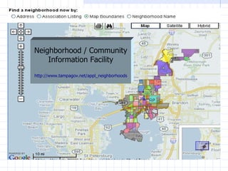
- 1. Neighborhood / Community Information Facility http://www.tampagov.net/appl_neighborhoods
- 2. Neighborhoods can be accessed by name, by address, or by selecting on a map.
- 3. Neighborhood association and general description information.
- 5. Characteristics within the City of Tampa.
- 8. Maps identifying neighborhood boundaries.
- 9. A catalog of all neighborhoods.
- 10. Printer Friendly (PDF) reports are producible for all information including aerial maps.
- 11. PDF’s are generated real-time to ensure current information.
Notas del editor
- The City of Tampa’s Technology and Innovation Department, along with the Neighborhood and Community Relations Department, developed and implemented an innovative interactive service featuring information on Tampa’s organized neighborhoods via the City of Tampa’s website -- www.tampagov.net. This innovative facility provides up-to-date information on Tampa’s neighborhoods along with city-wide issues of interest. Web visitors can select a specific neighborhood by clicking on a neighborhood from a map, entering an address, selecting a name from a menu of organized associations, or merely entering a neighborhood name. The service provides comprehensive coverage of the 100+ organized neighborhoods within the City of Tampa. Access to community information includes neighborhood association contacts, neighborhood and city-wide news postings, neighborhood meeting calendars and schedules, photographs covering all neighborhoods, area demographics (household characteristics, per capita income, population, racial and ethnic diversity, etc.), land use (residential, commercial, industrial, recreational, wetlands, etc.), and printable maps. The facility also highlights and provide access to unique neighborhood characteristics such as Tampa City Council districts, evacuation and flood zones, hospitals, libraries, parks and schools. The information delivered to the public incorporates data sources (via mash-ups) from various City departments along with external agencies such as Hillsborough County and U.S. Census Bureau. Printer ready renderings are provided for personal use (i.e. letter size), small meeting/committee use (i.e. ledger size), and large public forum use, such as the Planning Commission (i.e. plotter size). The service was introduced on May 8, 2007.