SlideShare una empresa de Scribd logo
1 de 5
‘Miniaturizing’ Cities!
In an era of mega-projects, can we look at our cities with the mind and skill of the traditional miniature artists? It might not
only be innovative, but also beneficial. Can we look at ‘walk-able cities’, where most of our life can be met through short,
healthy walks though green environs and public transport? Can we simply focus on the needs of different pockets of people
rather than on large scale public interventions? Can our present system of governance help see this through? Ahmedabad
can be a demonstrative example.

India accounts for 2.4 percent of the world’s land area, and yet holds about 16 percent of the world’s population, and only 1.7 percent of the
world’s forest stock. These are telling figures. Environmental experts recommend that at least a third of India’s geographical area should
have forest cover for sustainable environmental & economic development. Yet this is fast disappearing in the very name of economic de-
velopment. The situation in fact, is more drastic if we consider our urban centres, where the above figures clearly get further skewed, and
are deteriorating more rapidly due to growth pressures. This paper necessarily focuses on urban centres and what we can, and must do,
therein.
There are some thought-provoking cases to start with. The Sanjay Gandhi National Park is spread over 104 sq. km. in the middle of Greater
Mumbai, and Bangalore has the Bannerghatta Park spread over 100 sq. km. These are among the largest protected urban ‘forests’ in the
world today, located in some of the fastest growing mega-cities. Instead, Bangalore is fast becoming a desert! A 2010 Indian Institute of
Science (IISC) study reported that the city is becoming an ‘urban heat island’. The study found an incredible 632 per cent growth in the area
of Greater Bangalore during 1973-2009, leading to a 76% decline in vegetation and 79% decline in water bodies. IISC ecology professor
T.V. Ramachandra quantifies the impact: the city temperature has risen between two and four degrees due to shrinking water bodies and
green cover. The situation is worse in other Indian cities with much lesser ‘protected’ forest cover.
But this thermal change that causes physical & mental discomfort (with related cost issues) is not the only problem. These forest areas
also play a big role in maintaining the sources of water. According to a study done by Equilibrium Consultants, Bristol, one third (33 out of
105) of the world’s largest cities receive a significant proportion of their drinking water directly from nearby forest areas. This study in fact
quotes the Sanjay Gandhi National Park as a case in point, as two of the city’s main sources of drinking water, the Vihar and Tulsi lakes
are actually situated within the park. At least five other cities obtain water from sources that originate in distant watersheds that include
protected areas; and eight more obtain water from forests that are managed in a way that recognizes and gives priority to providing wa-
ter. Many cities today are suffering problems of irregular water supply due to depleting ground water. This has clear roots in disappearing
watersheds due to rapid deforestation and urbanization. This now becomes a calamitous double warning – for water and health.
Governments are just beginning to put an economic ‘price’ to resources, as they realize that economic growth is directly proportional to
the quality of life and its ecological resources. There is a related aspect that many city governments are spending heavily in, and that is,
infrastructure for public transport. But even the best designed public transport system needs feeder networks that link it at both ends to
the final destinations of users. Without these, one would not have effectively eliminated private transport. 31% of people walk to work in
Indian cities, says a 2008 study by the Ministry of Urban Development. A comparable population in our cities still use bicycles. But clearly
our planning neglects such users, whether it is in the design of streets or the provision of pavements, parks and gardens for pedestrians
to traverse the Indian city on foot.

This gives us our idea of ‘linking the greens’, which can address all the above issues. Let us start thinking of “walk-able cities”, where all
the essential aspects of one’s life, from living to working to access to basic amenities for daily needs, health, education & recreation, can be
covered through a half-hour walk. This can be achieved by linking these ‘walking routes’ along the network of existing green areas, to the
public transport routes and nodes. So, within a 1.5 km (20 minute) walk, one should be able to find basic amenities and also connect to a
public transport point, for access to the rest of the city. But one also has the option of walking further along the ‘greens’ or cycling longer,
to reach the same amenities or places of work. The routes can then be planted more intensively to increase the overall green cover. If we
start thinking like this, we can start planning, and taking the necessary decisions to make it happen.

If we make it possible for citizens to walk to public transport or cycle (as so many of them presently do), to their destinations, this will lead
to a decreased dependency on private motorised transport. Imagine the fall in numbers of vehicles on our streets, the consequent drop in
air pollution levels, and people being able to divert the time saved from commuting, waiting for transport or stalled in traffic, towards pro-
ductive or recreational activities! The economy improves by such integrated planning, but citizen health improves by 3 times, due to the
physical exercise of walking, pollution free air and lowered stress levels with reduced traffic hazards, noise and road rage.
Several gated colonies limit the motor able areas and clearly define the pedestrian portions amenable for children and elders. A little patch
of green in the Asiad Colony in Chennai, which was a barren sprawl a few years ago, is now celebrated by the World Health Organization.
Within seven years, doctors recorded a remarkable improvement in the fitness, blood sugar and cholesterol levels of over 500 neighbours
– all earlier in poor shape – who reinvented their lifestyles by walking in and around it. This is only proof of a long established link between
physical activity, fresh air and health.

There can be local regulations to ensure that these green areas are protected, and they along with the walk-able routes can see heavy
plantation drives. This would remarkably increase green cover, and have two added benefits. It would firstly, go a long way in increasing
rain water absorption, and secondly, allow the excess water to run-off clearly, into recharging tanks and further, into drains. These same
walking networks, hence can get combined with decentralized systems of water supply and sewage treatment, and allow us the possibility
of far more efficiently managed infrastructure networks than the presently struggling systems in our cities. This idea is taken ahead and
illustrated in the case of Ahmedabad, a rapidly growing urban centre.
One starts with different maps of the entire city. First, one showing the open areas (small and big, public and presently, even those pri-
vately owned), including the water bodies. These alone are revealing in terms of total size represented and also form interesting linkable
patterns. On this map, one can add the main road networks, and the main public transport networks. Here, the BRTS (Bus Rapid Transit
System) and the Ahmedabad Metro, as planned are shown. One can then work out informal pedestrian paths that can either avoid or run
parallel to the main roads and yet meet these routes at some touch points, which maybe commercial nodes or bus stations. As cycle-able
routes, these can in fact continue and link much further.
Another overlay on this can be one which shows the slum / squatter settlement pockets, as these are (and should be), our target clientele.
These are the large numbers of people who either walk, or use cycles or shared / public transport to their work. These are also the people
who are most affected by both the cost and health issues related to such travel. If we were to draw circles of 750 mt radius (20 minute
walk) along these routes, (presently shown here along the transport routes), one can see the reach of this idea. The same circles can be
drawn along the walking routes or around the main settlements. In fact, it is possible to connect the entire city through such linkages. The
western part of Ahmedabad has the erstwhile ‘green belt’, a planning idea developed in the ‘60’s, which sought to form a natural limit for
the outward growth and also to introduce / ensure a large breathing space for the city. This lends itself immediately to this idea. The east-
ern part of the town, has the erstwhile textile-mills, which now defunct, form large tracts of vacant ‘mill-lands’. By law, a portion of these
lands are to be diverted to public purposes, and our idea fits in perfectly for this. Similarly, there can be rules for protection of these areas
and intensive plantation. The water supply and sewage aspects can follow.
With such civic aspects entering, it is only natural to try and see these ‘circles / routes’ with the existing electoral units or wards. If we
started looking at each ward as the primary reference point, the local citizens and ward representatives / councillors would start relating
to such an idea, and through active public participation, this idea can be fine-tuned to maximise benefits. Further, the 74th Constitutional
Amendment seeks to devolve various responsibilities to ward level, thereby de-centralising traditional decision making powers; hence the
councillors can actually take ownership and responsibility of the idea, and this can ensure that it actually gets implemented. If we were to
even start with 2-3 wards that are adjacent, we have the beginnings of our ‘ideal’ network. The beauty of the idea is also that, even within
one ward, there will be benefits, albeit for local residents. Over time, as further wards adopt the idea, there can be a much larger benefit
to the overall health of the citizens & quality of life that the city provides.

Our traditional cities were often illustrated through picturesque miniature paintings, with many trees, water, flora and fauna, in addition to
people, buildings and activities. In addition to being idyllic, I think, they hold a great ‘ideal’ for our cities. As planners, we need to under-
stand this hidden message, much as our art historians & aestheticians have understood their larger spiritual message. A good way to think
about our growing mega-cities is to ‘miniaturize’ them. Think small, within a well defined scope and for clear tangible benefits to needs and
linkages. All this at no extra cost, but only by locating clearly what exists, linking them, and maximising their worth. Unlike present day
planning that largely focuses on the newer areas, it is necessary that we realize the potentials of our existing ‘old’ cities, and establish a
more direct co-relation to the happiness and well being of our citizens. We may have a solution to many of our problems, and the begin-
nings of a new happier urban reality.


Rajeev Kathpalia
Architect & Urban Designer, Ahmedabad

Más contenido relacionado

Más de www.theurbanvision.com

Leaders Study Program, Vancouver 2018-Pfs studio
Leaders Study Program, Vancouver 2018-Pfs studioLeaders Study Program, Vancouver 2018-Pfs studio
Leaders Study Program, Vancouver 2018-Pfs studiowww.theurbanvision.com
 
Leaders Study Program, Vancouver 2018- Pfs studio
Leaders Study Program, Vancouver 2018- Pfs studioLeaders Study Program, Vancouver 2018- Pfs studio
Leaders Study Program, Vancouver 2018- Pfs studiowww.theurbanvision.com
 
Leaders Study Program, Vancouver 2018- dvbia presentation
Leaders Study Program, Vancouver 2018- dvbia presentation   Leaders Study Program, Vancouver 2018- dvbia presentation
Leaders Study Program, Vancouver 2018- dvbia presentation www.theurbanvision.com
 
Leaders Study Program, Paris 2019- Great paris
Leaders Study Program, Paris 2019- Great parisLeaders Study Program, Paris 2019- Great paris
Leaders Study Program, Paris 2019- Great pariswww.theurbanvision.com
 
Leaders Study Program, Paris 2019- Movin'on lab presentation
Leaders Study Program, Paris 2019- Movin'on lab presentationLeaders Study Program, Paris 2019- Movin'on lab presentation
Leaders Study Program, Paris 2019- Movin'on lab presentationwww.theurbanvision.com
 
Leaders Study Program, Paris 2019 -Nanterre en_v2
Leaders Study Program, Paris 2019 -Nanterre en_v2Leaders Study Program, Paris 2019 -Nanterre en_v2
Leaders Study Program, Paris 2019 -Nanterre en_v2www.theurbanvision.com
 
Leaders Study Program, Paris 2019- BNP Paribas
Leaders Study Program, Paris 2019- BNP ParibasLeaders Study Program, Paris 2019- BNP Paribas
Leaders Study Program, Paris 2019- BNP Paribaswww.theurbanvision.com
 
Leaders Study Program, Paris 2019 - BNP Paribas
Leaders Study Program, Paris 2019 - BNP ParibasLeaders Study Program, Paris 2019 - BNP Paribas
Leaders Study Program, Paris 2019 - BNP Paribaswww.theurbanvision.com
 
Leaders Study Program, Paris 2019- APUR
Leaders Study Program, Paris 2019- APURLeaders Study Program, Paris 2019- APUR
Leaders Study Program, Paris 2019- APURwww.theurbanvision.com
 
Leaders Study Program, Paris 2019- City hall
Leaders Study Program, Paris 2019- City hall Leaders Study Program, Paris 2019- City hall
Leaders Study Program, Paris 2019- City hall www.theurbanvision.com
 
LSP : Copenhagen & Malmo: Tredje Natur
LSP : Copenhagen & Malmo: Tredje NaturLSP : Copenhagen & Malmo: Tredje Natur
LSP : Copenhagen & Malmo: Tredje Naturwww.theurbanvision.com
 
LSP : Copenhagen & Malmo: Ramboll - New urban experiments
LSP : Copenhagen & Malmo: Ramboll - New urban experimentsLSP : Copenhagen & Malmo: Ramboll - New urban experiments
LSP : Copenhagen & Malmo: Ramboll - New urban experimentswww.theurbanvision.com
 
LSP : Copenhagen & Malmo- Revival of Malmo
LSP : Copenhagen & Malmo-  Revival of MalmoLSP : Copenhagen & Malmo-  Revival of Malmo
LSP : Copenhagen & Malmo- Revival of Malmowww.theurbanvision.com
 
LSP : Copenhagen & Malmo- Architecture Creates Value
LSP : Copenhagen & Malmo- Architecture Creates ValueLSP : Copenhagen & Malmo- Architecture Creates Value
LSP : Copenhagen & Malmo- Architecture Creates Valuewww.theurbanvision.com
 
LSP : Copenhagen & Malmo- Bicycle infrastructure
LSP : Copenhagen & Malmo- Bicycle infrastructureLSP : Copenhagen & Malmo- Bicycle infrastructure
LSP : Copenhagen & Malmo- Bicycle infrastructurewww.theurbanvision.com
 
LSP : Copenhagen & Malmo- Gehl Architects
LSP : Copenhagen & Malmo- Gehl ArchitectsLSP : Copenhagen & Malmo- Gehl Architects
LSP : Copenhagen & Malmo- Gehl Architectswww.theurbanvision.com
 
LSP : Copenhagen & Malmo-COBE -Paper Island & Kroyers Platz
LSP : Copenhagen & Malmo-COBE -Paper Island & Kroyers PlatzLSP : Copenhagen & Malmo-COBE -Paper Island & Kroyers Platz
LSP : Copenhagen & Malmo-COBE -Paper Island & Kroyers Platzwww.theurbanvision.com
 

Más de www.theurbanvision.com (20)

Leaders Study Program, Vancouver 2018-Pfs studio
Leaders Study Program, Vancouver 2018-Pfs studioLeaders Study Program, Vancouver 2018-Pfs studio
Leaders Study Program, Vancouver 2018-Pfs studio
 
Leaders Study Program, Vancouver 2018- Pfs studio
Leaders Study Program, Vancouver 2018- Pfs studioLeaders Study Program, Vancouver 2018- Pfs studio
Leaders Study Program, Vancouver 2018- Pfs studio
 
Leaders Study Program, Vancouver 2018- dvbia presentation
Leaders Study Program, Vancouver 2018- dvbia presentation   Leaders Study Program, Vancouver 2018- dvbia presentation
Leaders Study Program, Vancouver 2018- dvbia presentation
 
Leaders Study Program, Paris 2019- Great paris
Leaders Study Program, Paris 2019- Great parisLeaders Study Program, Paris 2019- Great paris
Leaders Study Program, Paris 2019- Great paris
 
Leaders Study Program, Paris 2019- Movin'on lab presentation
Leaders Study Program, Paris 2019- Movin'on lab presentationLeaders Study Program, Paris 2019- Movin'on lab presentation
Leaders Study Program, Paris 2019- Movin'on lab presentation
 
Leaders Study Program, Paris 2019 -Nanterre en_v2
Leaders Study Program, Paris 2019 -Nanterre en_v2Leaders Study Program, Paris 2019 -Nanterre en_v2
Leaders Study Program, Paris 2019 -Nanterre en_v2
 
Leaders Study Program, Paris 2019- BNP Paribas
Leaders Study Program, Paris 2019- BNP ParibasLeaders Study Program, Paris 2019- BNP Paribas
Leaders Study Program, Paris 2019- BNP Paribas
 
Leaders Study Program, Paris 2019 - BNP Paribas
Leaders Study Program, Paris 2019 - BNP ParibasLeaders Study Program, Paris 2019 - BNP Paribas
Leaders Study Program, Paris 2019 - BNP Paribas
 
Leaders Study Program, Vancouver 2018
Leaders Study Program, Vancouver 2018Leaders Study Program, Vancouver 2018
Leaders Study Program, Vancouver 2018
 
Leaders Study Program, Paris 2019- APUR
Leaders Study Program, Paris 2019- APURLeaders Study Program, Paris 2019- APUR
Leaders Study Program, Paris 2019- APUR
 
Leaders Study Program, Paris 2019- City hall
Leaders Study Program, Paris 2019- City hall Leaders Study Program, Paris 2019- City hall
Leaders Study Program, Paris 2019- City hall
 
Women Friendly Cities : A Primer
Women Friendly Cities : A PrimerWomen Friendly Cities : A Primer
Women Friendly Cities : A Primer
 
LSP : Copenhagen & Malmo:SLA
LSP : Copenhagen & Malmo:SLALSP : Copenhagen & Malmo:SLA
LSP : Copenhagen & Malmo:SLA
 
LSP : Copenhagen & Malmo: Tredje Natur
LSP : Copenhagen & Malmo: Tredje NaturLSP : Copenhagen & Malmo: Tredje Natur
LSP : Copenhagen & Malmo: Tredje Natur
 
LSP : Copenhagen & Malmo: Ramboll - New urban experiments
LSP : Copenhagen & Malmo: Ramboll - New urban experimentsLSP : Copenhagen & Malmo: Ramboll - New urban experiments
LSP : Copenhagen & Malmo: Ramboll - New urban experiments
 
LSP : Copenhagen & Malmo- Revival of Malmo
LSP : Copenhagen & Malmo-  Revival of MalmoLSP : Copenhagen & Malmo-  Revival of Malmo
LSP : Copenhagen & Malmo- Revival of Malmo
 
LSP : Copenhagen & Malmo- Architecture Creates Value
LSP : Copenhagen & Malmo- Architecture Creates ValueLSP : Copenhagen & Malmo- Architecture Creates Value
LSP : Copenhagen & Malmo- Architecture Creates Value
 
LSP : Copenhagen & Malmo- Bicycle infrastructure
LSP : Copenhagen & Malmo- Bicycle infrastructureLSP : Copenhagen & Malmo- Bicycle infrastructure
LSP : Copenhagen & Malmo- Bicycle infrastructure
 
LSP : Copenhagen & Malmo- Gehl Architects
LSP : Copenhagen & Malmo- Gehl ArchitectsLSP : Copenhagen & Malmo- Gehl Architects
LSP : Copenhagen & Malmo- Gehl Architects
 
LSP : Copenhagen & Malmo-COBE -Paper Island & Kroyers Platz
LSP : Copenhagen & Malmo-COBE -Paper Island & Kroyers PlatzLSP : Copenhagen & Malmo-COBE -Paper Island & Kroyers Platz
LSP : Copenhagen & Malmo-COBE -Paper Island & Kroyers Platz
 

Rajeev Kathpalia: Blueprint – Vision for future Cities

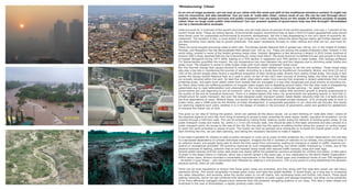
  • 1. ‘Miniaturizing’ Cities! In an era of mega-projects, can we look at our cities with the mind and skill of the traditional miniature artists? It might not only be innovative, but also beneficial. Can we look at ‘walk-able cities’, where most of our life can be met through short, healthy walks though green environs and public transport? Can we simply focus on the needs of different pockets of people rather than on large scale public interventions? Can our present system of governance help see this through? Ahmedabad can be a demonstrative example. India accounts for 2.4 percent of the world’s land area, and yet holds about 16 percent of the world’s population, and only 1.7 percent of the world’s forest stock. These are telling figures. Environmental experts recommend that at least a third of India’s geographical area should have forest cover for sustainable environmental & economic development. Yet this is fast disappearing in the very name of economic de- velopment. The situation in fact, is more drastic if we consider our urban centres, where the above figures clearly get further skewed, and are deteriorating more rapidly due to growth pressures. This paper necessarily focuses on urban centres and what we can, and must do, therein. There are some thought-provoking cases to start with. The Sanjay Gandhi National Park is spread over 104 sq. km. in the middle of Greater Mumbai, and Bangalore has the Bannerghatta Park spread over 100 sq. km. These are among the largest protected urban ‘forests’ in the world today, located in some of the fastest growing mega-cities. Instead, Bangalore is fast becoming a desert! A 2010 Indian Institute of Science (IISC) study reported that the city is becoming an ‘urban heat island’. The study found an incredible 632 per cent growth in the area of Greater Bangalore during 1973-2009, leading to a 76% decline in vegetation and 79% decline in water bodies. IISC ecology professor T.V. Ramachandra quantifies the impact: the city temperature has risen between two and four degrees due to shrinking water bodies and green cover. The situation is worse in other Indian cities with much lesser ‘protected’ forest cover. But this thermal change that causes physical & mental discomfort (with related cost issues) is not the only problem. These forest areas also play a big role in maintaining the sources of water. According to a study done by Equilibrium Consultants, Bristol, one third (33 out of 105) of the world’s largest cities receive a significant proportion of their drinking water directly from nearby forest areas. This study in fact quotes the Sanjay Gandhi National Park as a case in point, as two of the city’s main sources of drinking water, the Vihar and Tulsi lakes are actually situated within the park. At least five other cities obtain water from sources that originate in distant watersheds that include protected areas; and eight more obtain water from forests that are managed in a way that recognizes and gives priority to providing wa- ter. Many cities today are suffering problems of irregular water supply due to depleting ground water. This has clear roots in disappearing watersheds due to rapid deforestation and urbanization. This now becomes a calamitous double warning – for water and health. Governments are just beginning to put an economic ‘price’ to resources, as they realize that economic growth is directly proportional to the quality of life and its ecological resources. There is a related aspect that many city governments are spending heavily in, and that is, infrastructure for public transport. But even the best designed public transport system needs feeder networks that link it at both ends to the final destinations of users. Without these, one would not have effectively eliminated private transport. 31% of people walk to work in Indian cities, says a 2008 study by the Ministry of Urban Development. A comparable population in our cities still use bicycles. But clearly our planning neglects such users, whether it is in the design of streets or the provision of pavements, parks and gardens for pedestrians to traverse the Indian city on foot. This gives us our idea of ‘linking the greens’, which can address all the above issues. Let us start thinking of “walk-able cities”, where all the essential aspects of one’s life, from living to working to access to basic amenities for daily needs, health, education & recreation, can be covered through a half-hour walk. This can be achieved by linking these ‘walking routes’ along the network of existing green areas, to the public transport routes and nodes. So, within a 1.5 km (20 minute) walk, one should be able to find basic amenities and also connect to a public transport point, for access to the rest of the city. But one also has the option of walking further along the ‘greens’ or cycling longer, to reach the same amenities or places of work. The routes can then be planted more intensively to increase the overall green cover. If we start thinking like this, we can start planning, and taking the necessary decisions to make it happen. If we make it possible for citizens to walk to public transport or cycle (as so many of them presently do), to their destinations, this will lead to a decreased dependency on private motorised transport. Imagine the fall in numbers of vehicles on our streets, the consequent drop in air pollution levels, and people being able to divert the time saved from commuting, waiting for transport or stalled in traffic, towards pro- ductive or recreational activities! The economy improves by such integrated planning, but citizen health improves by 3 times, due to the physical exercise of walking, pollution free air and lowered stress levels with reduced traffic hazards, noise and road rage. Several gated colonies limit the motor able areas and clearly define the pedestrian portions amenable for children and elders. A little patch of green in the Asiad Colony in Chennai, which was a barren sprawl a few years ago, is now celebrated by the World Health Organization. Within seven years, doctors recorded a remarkable improvement in the fitness, blood sugar and cholesterol levels of over 500 neighbours – all earlier in poor shape – who reinvented their lifestyles by walking in and around it. This is only proof of a long established link between physical activity, fresh air and health. There can be local regulations to ensure that these green areas are protected, and they along with the walk-able routes can see heavy plantation drives. This would remarkably increase green cover, and have two added benefits. It would firstly, go a long way in increasing rain water absorption, and secondly, allow the excess water to run-off clearly, into recharging tanks and further, into drains. These same walking networks, hence can get combined with decentralized systems of water supply and sewage treatment, and allow us the possibility of far more efficiently managed infrastructure networks than the presently struggling systems in our cities. This idea is taken ahead and illustrated in the case of Ahmedabad, a rapidly growing urban centre.
  • 2.
  • 3.
  • 4.
  • 5. One starts with different maps of the entire city. First, one showing the open areas (small and big, public and presently, even those pri- vately owned), including the water bodies. These alone are revealing in terms of total size represented and also form interesting linkable patterns. On this map, one can add the main road networks, and the main public transport networks. Here, the BRTS (Bus Rapid Transit System) and the Ahmedabad Metro, as planned are shown. One can then work out informal pedestrian paths that can either avoid or run parallel to the main roads and yet meet these routes at some touch points, which maybe commercial nodes or bus stations. As cycle-able routes, these can in fact continue and link much further. Another overlay on this can be one which shows the slum / squatter settlement pockets, as these are (and should be), our target clientele. These are the large numbers of people who either walk, or use cycles or shared / public transport to their work. These are also the people who are most affected by both the cost and health issues related to such travel. If we were to draw circles of 750 mt radius (20 minute walk) along these routes, (presently shown here along the transport routes), one can see the reach of this idea. The same circles can be drawn along the walking routes or around the main settlements. In fact, it is possible to connect the entire city through such linkages. The western part of Ahmedabad has the erstwhile ‘green belt’, a planning idea developed in the ‘60’s, which sought to form a natural limit for the outward growth and also to introduce / ensure a large breathing space for the city. This lends itself immediately to this idea. The east- ern part of the town, has the erstwhile textile-mills, which now defunct, form large tracts of vacant ‘mill-lands’. By law, a portion of these lands are to be diverted to public purposes, and our idea fits in perfectly for this. Similarly, there can be rules for protection of these areas and intensive plantation. The water supply and sewage aspects can follow. With such civic aspects entering, it is only natural to try and see these ‘circles / routes’ with the existing electoral units or wards. If we started looking at each ward as the primary reference point, the local citizens and ward representatives / councillors would start relating to such an idea, and through active public participation, this idea can be fine-tuned to maximise benefits. Further, the 74th Constitutional Amendment seeks to devolve various responsibilities to ward level, thereby de-centralising traditional decision making powers; hence the councillors can actually take ownership and responsibility of the idea, and this can ensure that it actually gets implemented. If we were to even start with 2-3 wards that are adjacent, we have the beginnings of our ‘ideal’ network. The beauty of the idea is also that, even within one ward, there will be benefits, albeit for local residents. Over time, as further wards adopt the idea, there can be a much larger benefit to the overall health of the citizens & quality of life that the city provides. Our traditional cities were often illustrated through picturesque miniature paintings, with many trees, water, flora and fauna, in addition to people, buildings and activities. In addition to being idyllic, I think, they hold a great ‘ideal’ for our cities. As planners, we need to under- stand this hidden message, much as our art historians & aestheticians have understood their larger spiritual message. A good way to think about our growing mega-cities is to ‘miniaturize’ them. Think small, within a well defined scope and for clear tangible benefits to needs and linkages. All this at no extra cost, but only by locating clearly what exists, linking them, and maximising their worth. Unlike present day planning that largely focuses on the newer areas, it is necessary that we realize the potentials of our existing ‘old’ cities, and establish a more direct co-relation to the happiness and well being of our citizens. We may have a solution to many of our problems, and the begin- nings of a new happier urban reality. Rajeev Kathpalia Architect & Urban Designer, Ahmedabad