abortion pills in Riyadh+966572737505 Cytotec Riyadh
Aaaaaaaaaa
1. Recent Surveys in Sinai and Palestine
Author(s): C. W. Wilson
Reviewed work(s):
Source: Journal of the Royal Geographical Society of London, Vol. 43 (1873), pp. 206-240
Published by: Blackwell Publishing on behalf of The Royal Geographical Society (with the Institute of
British Geographers)
Stable URL: http://www.jstor.org/stable/1798627 .
Accessed: 20/03/2012 15:56
Your use of the JSTOR archive indicates your acceptance of the Terms & Conditions of Use, available at .
http://www.jstor.org/page/info/about/policies/terms.jsp
JSTOR is a not-for-profit service that helps scholars, researchers, and students discover, use, and build upon a wide range of
content in a trusted digital archive. We use information technology and tools to increase productivity and facilitate new forms
of scholarship. For more information about JSTOR, please contact support@jstor.org.
Blackwell Publishing and The Royal Geographical Society (with the Institute of British Geographers) are
collaborating with JSTOR to digitize, preserve and extend access to Journal of the Royal Geographical Society
of London.
http://www.jstor.org
2. 206 WILSON'S Surueys Sinai andPalestine.
Becent in
Now the questionmaybe asked: Cfxiborl,o this toil of
all
analysis research
and devoted a docume:xltunimportant
to so in
sizeandof suchlimited contents The facts mayanswerfor
?
themselves.
1. If the realities whichllave been hele laid barehad been
detected timednring lastthreecenturies a quarterS
ally the and
so that the site of the lost East Colony Greenland been
of had
proved demonstration
to instead beinga matterof opinion,*
of
the liings of Denmark would havebeenspared necessity
the of
sending a greatnumber unsuccessful
out of expeditions: and
2. A nuinber learneddisquisitions some of the mosk
of by
illustrious literaZi in Europewouldhave been re:ndered super
fluous.
3. The Zenodocument nowsllown be the latest in exist-
is to
ence as faras we know,givingdetailsrespecting important
the
lost East Colony Greenland,
of which has been so ansiously
sought for.
4. It is the tatest document existence, far as mre
in as knowy
giving details respecting the Europeansettlers in North
America-although centurya be.fore Columbus's great voyage
acrossthe Atlantic-and showinffl they still survivedat
that
thatperiod.
5. Thehonour a distinguished
of man,whoseonlyfaultsas
regards this ancientstoryn fruitfulill mischiefas they have
been,^Tere he did not possess geographical
that the knowledge
of to-day, that he indulged the glowing
and in fancies diction
and
of his sunnycountry, beenvindicated:
has and
6. The bookwhichhasbeendeclared be "one of the most
to
puzzling the wholecircleof literature will henceforth no
in ' be
puzzleat al].
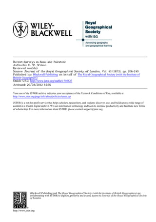
Sxrveys StnatanZPatestine. By Major w.
IX. RecenG tn a.
WIL8QN,R.E.
[Read, June 23rd, 1873.]
THEBWEfew countries the world
are in which, withinthe same
area,present manyfeatures generalinterestas Sinaiand
so of
* There can be no better proof of the correctness of th;s statement than the^
fact that while the true site was correctly believed iIl by Eggers in 1794,
Captain Graah was sent out ill 1828 to learn, if possible, whether the site were
on the east or the west coast- and even thoufflh he himself correctly helieved in
the true site, his pleas, on behalf of his convictions, were so inconclusive, that
the learned author of ' Iceland, Greenland, and the Faroe Isltds,' in 1840, after
well weighing the argtlments, says: "For these reasons we are disposed to
regard thist point not only as still undecided, but one on which without moro
endence it would be premature to come to any conclusion."
4. iN
.>>;;
t ) A )xt "I,'l'w';
_>_ii <s^zvat-*rrz
.... r 'S - 3{)' +r X
. .
ta face miwe 2D7
36?30' 3S7340
'
Hd*eNiS
E
t ' / 2 /<9' 3a'
> i 3'' C
h,,,,2'"5" < t >,
X %& . - aN-
< -"S g
> &; A 4 53?
| ,,j.t .
: '
e
gk
X, D
30'
v
46>
W
t
M[.%,>
>$a'5S
. . .
32
- s a
A -e,,
a i.^j:!v
_ r v
r
iAkiMi5
)R
rffl,e"
5. x!N',ih!St > X -<4 OY e o r b eb w
P F
$ S +W W !4 --
7 eAS
A1!,,elul,l<iS?J
t 9[:|-
J 4 ov C >9 , - v i,,s,
i; !. i.% ' u
9-7xt"v< t->- f-
Scde
;,4sX ii'|
w"" w She fieres Ze
2
.} <.;.
as? 3o?30 36?
-
Bubushedvffr zie.To7trna,oft77sRogyaGjSJcogrv17QMSocmy,ty Jo7Mttrray,X7ba?Lor1X5treet,Lonuors,1873.
6. xove
b or 20
beLow the 7>e?vet
S0 of Bera>w , , ,! 1 ^ tiT n 1
MAP
PHYSICAL 30#
of
EALE$TENE
b,y
to aW7mpc<ythe:Paper
Major C.W.MllsonR.E.
Scale of b?sh Stae ffiles
40 so
I,e 75pres Snote t7Le aZe or kressorlJ
"3oo
36?p0'
En3raved by ZdwWWeller
73.
7. WILSON'S Recezt
Stlrveys Sinai andPalestixae. 207
in
Palestine, it is oulymrithin lastfewyearsthatanyattempt
yet the
hasbeenmaUle submit
to themto that thorough systematic
arld
examination whichis alike demanded the geographer,
by the
geologist,the arGhseologist, the Biblical studellt. This
and
workhas beenundertaken tlle PalestineExploration
by Fund,
andotherkindredsocieties,and the following pape.r been
has
prepared with a vielv of drawingattentionto what may be-
called the geographical results of their labours,and more
especially the progress the Trigorlometrical
to of Surveylvhich
wascommenced 1871.in
The field of operations be said to e:ttendfromMount
may
Hermon, lat. 33?26' 10"s., on the north,to Ras Muhammed
in
in lat. 27? 43' 20t' N. on the south, andfromthe Mediterranean
on the west to the longitudeof Damascus36? 18' 24t'E., 0I1
the east-an areaof 40,000 square miles.
For the present, however, various considerations,principally
thosearisingfromwantof funds,haveinducedthe societies to
confine their attentionto Palestineproper, whichincludesan
areaof about12,000square miles.
At RasMuhammed greatfissure the Red Seabranchess
the of
off to the rightandleft, onearmforming Gulf of Suez,the
the
other,underthe severalnamesof the Gulf of 'Akabah,the
Arabah, Ghor,and the Buleaa,
the stretching llorthwards to
the vicinityof Antioch. At the southernestretnityof the
peninsula Sinairise the SinaiticMountairls, vast crystal-
of a
line mass.similarin character the adjoining
to mountains of
Africa and Arabia;on the eastthey descendabruptlyto the
Gulf of 'Akabah, whilst on the west they are flankedby an
arid plain,vhich es:tends almostwithoutinterruption theto
Mediterranean, forsomedistance
alld, northof Tur is separated
fromthe Gulf of ?bues a loxv
by rangeof hills of tertXiary
sand-
stone. Northward, broken sandstonedistrict,sornetimes
a
known the Debbeter Ramleh,
as separates Sinaitic
the Moun
tains fromthe liinestone plateauof the Till, a drearydesert
that falls gradually towards north,alld is chieflydrailled
the
by the great NVady Arish, the River of Egypt of the
el
Bible.
To the plateauof the Tih succeed,on the north-east, the
limestonehills of Judeea, rising near :Etebron a height of
to
2840 feet. Thismountain range,whichhas been aptlycalled
the "backbone of Palestine,runs north to Esdraelon,
" with
slightlyvarvingaltitucleand then,after throwing a spllr
out
westwarA Carmel, linkedto the Lebanon the Hills of
to is by
Galilee,which attai:rl their culminating point in Jebel Jer-
muk,4000 high. West of this centralrangees;tend
feet with
varying breadth maritime
the plainsof Philistiaand Phcenicia,
8. 208 ILSON'S Sleruysin
Rccewlt Si?lai and Pa7estile.
vhilston the eastlies the deplession the Joldan,formin a
of
llatural separation betweenPalestineand the great eastern
3?1ateall, stretclles
which awayalmostto tlle Euphrates.
The peninsula Sinai has beenn7ell
of described a ';desert
as
of roch,gravel,anflboulder, gauntpeahs,dreary
of ridges, and
aridvalleys; * it is extremely wild and ruggecl, is inter-
and
sectedby oneof tlle lnost conaplicated systemsof drainage ill
the wolld. The greatcrvstalline nlasswhichformsa it were,
as
the "core' of the pe:iinsula, split up into irlnunilerable
is
peaks,that attaill a collsiderable altitude Jf3bel Zetir, So51
feet; J. Waterin, Sa36 feet; J. Umm Shomern 8449 feet; J.
Musa, 7375feet; andJ. Serbal, 6734feet-and present viewsof
the mostgrandand impressive character Tlle sandstone dis-
trict,richill alltiquities mineral
and wealth, broken illto
is up
quaintforms,whicll,combined ^7ith riclocovering,
the give a
peculiar chartnto the seenery;in tlle cretaceous tertiary
and
Elistricts, the otherhalld,the features devoidof interest,
on are
andthe scellery monotonous,
is e2ccept when lightedup by the
riGh glowof therisingorsettingsun. Thewadies, salleysn or are
deeply cut, and descend rapidlyto the sea; thev frequently
take theirrisein openplains, "fershs,"
oz tllat lie at the foot
of the peaks,and forinone of the most interesting topogra-
phicalfeatures the interior. valleysappear havebeen
of The to
formed the actionof water,andin manyplacesalongtlleir
by
sides are loft.ybanksof alluvium,lvllich,according some to
vriters,markthe existence, a lemoteperiod, inland
at of lakes;.
The +^rater supplyis lllore abundallt than llas generally bee
supposed,and in the mountaindistricts,especiallvin tile
icinityof JebelAlusa, tllereareseveral smallperenlwial streanls,
andnumerous springs good
of water.'l'he sandstone limestone
and
districts badly
are supluliecl tlle waterfound the latteris
and in
rbrackish laasa purgative
and effect. Thereis onehot Spl'ilNg
t
at the foot of Jebel HammalaFal'tlu; the temperature is
157?.
Thevegetationls sparse, there are llot +sTanting
but indica-
tionstllatit wasformerly mc)re plentiful;es-ellllOW thereis, at
certainseasolls the rearfa considerable
of aluount lregetatioll
of
on the upland pla;nsn in addition the well-knowll of
and to oasis
Beiran there are severalothersscattered over the peninsula.
The climateis verylTariable; in the higherdistricts coldin
the
vinteris severe,and the peaksare fiequentlycoxrered lvitl
snoxv;in the lowerdistrictsthe heat is illtense, and,lvllenthe
* Capt.Palmer,in; Ordnance Surveyof Sinai' sol. i. p. 17
t This arisesfromthe lart,equantities carbonate sodaand othersalis 11e111
of of
in solution.
9. 'ILSON'S Recent
Surveys StnaiandPcllestine. 209
iwl
khamsill blows, almostunbearable.The air is dry,clear,and
bracing,alld there i8 alsvas a great diSerellcebetweenthe
niglat day temperature; averagerainfallis small but
and the
the country subjectto localstormsof greatviolence,
is which
produce "seils,"or floods, muclldreaded the Bedawill.
the so by
Oneof these11as been grapllically
described an eye-witness,
by
AIr.Holland it will suffice mentionhere that on this oc-
;* to
casionthe bed of the great M;adyFeiranwas at one platfe
washed to a depthof 8 feet; andtllatin the gorgeof Wady
out
Sigilliyehthe waterroseto a heightof 30 feet,and then,aftel
running nearly milesoverthe dryslesert E1Ga'ah,
20 of entered
the sea nearTura broad riverfrom3 to t feet deep.
Oneof the most strikingfeatures Palestineproperis its
of
natural divisioninto four parallelstrips-the CoastlUlain,
the
Hill Country, Jordan
the Valley,andthe Eastern Plateau.The
CoastPlain,from10 to 20 mileswide,extends without brealv
a
fiomthe deserton the south to hIountCarmel the north;
on
beyond Calmel the Plainof Acre,about20 mileslongand
lies
4 to 6 wide,andthis againis separated fromthe narrow Plain
of Phoeniciaby Ras en Nakurah,better known as the Ladder
of Tyre. The greaterportionof the plain is fertile and culti-
sated, but north of the Nahr Aujell there are low hills of tel-
tiary sandstone,which check the drainagefrom the mountains,
and give rise to several larre swamps; these vere formerly
dlained by tunnels or drifts cut through the hills, which are
nowchoked withrubbish. TheHill Countrycommencesabout
50 milessoutllof the BIediterranean, interrupted
and, oulyby
the PlaiIIof Esdraelola, traverses countryfronlsouth to
tlle
north. The hills are broad-backed, there is no marked
and
grandeur their physicalfeatures, everyhere and there
in but
rounded summits abovethe generalSevel tlle range,
rise of and
aSordstrikingpanoramas the surrounding
of country. The
averagealtitudemaybe gathered fromthe following heights:-
Hebron, 2840 feet; Mount Olives,
of 2665 feet; Neby Samwil,
2900 feet; Jebel Hazur,3165 feet; MountEbal, 3029 feet;
Jebel Fukua,1716feet; Neby Ismail (Nazareth), 1790 feet;
JebelJermuk, 40()0feet.
The main road from Jerusalem Nablus,Nazareth,
to and
Baniasfollomrs line of water-parting, in close prosi-
the and
mity to it were the most importantcities of Judah and Israel.
Onthe east the hills descendrapidly the Jordan,and are
to
furrowed cleft by deep, wild torrentbeds; whiIston the
and
west they fall, at first abruptly, then pass,by a seriesof
and
low,1lndulating hills, the " Shephelah," " low country of
or "
* ' RoyalGeo,,raphical
Society's
Journal,' s2Zviii. p. 148.
sol.
VOL. XLIII. p
10. 210 WILSON'S Surveys Sinai andPalestine.
Recent i?l
Scripture,to the AtaritimePlain. The valleys for the most
part take their rise in small upla:nd plains,and,preservinffl gene-
rally an east andwestdirection, debouch, after an infinitevariety
of windings,on the Coast Plaill and the JordallValley.
Tlle JordanValley runs nearly parallel to the coast from the
baseof MountHermon the Dead Sea,whichoccupiesits deepest
to
portion. South of the Dead Sea the valley rises graduallyfor
about 68 Iniles to the water-parting which, at all altitude of
7814 feet, separatesthe sraters of the Dead Sea from those
of the GLulf XAkabah. This water-parting,
of which links the
Tih to Arabia, is, according to M. Lartet,a cretaceousbarrier
separatingin the lnost completemannerthe two slopesof the
district. The cretaceous strata are covered with their own
(lebris,and sllowno trace of any water-coursein the direction
of the Red Sea.
The Eastern Plateau attains its greatestaltitude at FJS Salt,
2771 feet; it is tolerably uniform in its characteristics, and
naintains, as far north as Banias, a general altitude of about
2000 feet. At this point the grand peak of l]:ermonrises to a
lleight of 8700 feet, and formsthe commencement the range
of
of Arlti Lebanon. Orl the north the great plateau is covered
by the basaltsof the Jaulan, and east of them lie the volcanic
hills of the Hallranand Ledja.
The one great liver of the countrv Jordan, a river
is tlle
whicll, as Ritter justly obselvesS wholly unique: " There is
is
no other like it on tlle whole face of the earth; a purely inland
river, having no embouchure the sea, and closing its course
on
at the very deepest part of the Old Vorld,and far below the
level of the ocean.7 After the Junctionof the three strealns,
whichrise respectivelyat HaslDeiya., el liady, and Banias,
Tell
tlle Jordan spreads out into the lake E1 Huleh, and thence
descends rapidly to the Sea of Galilee; from tllis lake it
fO11OWS 66 miTeS tOrtUOUS
fOr a COUrSe, W11011Y the 1eVe1
be1OW
Of the MediteRranUan, the Dead Sea. FrOE Te11e1 WadY
tO
to E1 Huleh theie is a fall of 328 feet in 11@9 miles, fron El
Huleh to the Sea of Galilee a fall of 898 75 in 111 miles, and
froznthe Sea of Galilee to the Dead Sea a fall of 665a75feet in
65 9 miles. From the Dead Sea to the water-parting there is &
rise of 2()73feet in 67)9 lmiles,and from the water-parting to
the Gulf of 'Akaball there is a fall of 781 feet in 40 7
miles. The Jordan has severaltributaries,of which the most
important are the Yarmuk al3d Zerka on the east and the
streams in MTadies Jalud and Ferla on the west; in addition
to these, Wadies :Rubadiyeh and lIammaln discharge their
watersinto the Sea of Galilee, and WVadies ZerkaMain, Zlojib,
Rerak, a:ndAhsi into the Dead Sea. There are also several
11. WILSON'S Recent
Surveys Sinai andPalestine.
in 211
streams runnillg westward thecoast,as the Litany(Leontes)
to
Naman (Bellls), and the :Kishon, northof Carmel;and the
Belka, Zerka,Aklldar, and Aujeh,to the south. Tlaere are
;numerous sprilags good freshwater,
of and severalhot springs,
of whichthe principal thosenearTiberias
are (132-2? 142l2?),
to
thosenearUmmReis (Gadara), 110?; andthose at Callirrhoe,
in W. Zerka Alain, 120?.
Palestine was evidentlyat one time thiclily coveredwitll
forests,but they have elltirelydisappeared, except in a few
placesOllthe mountains alongthe sea coast,and tlle only
and
existing tracesare tlle roots,that forln one of tlle plincipal
sourcesfromwhich charcoal firewood obtained. The
and ale
plainsand rockyhills are,in spring, carpeted with herbaceous
plants,but they soondisappear underthe burningSUll of sum-
mer,andtlle coUntly thenassumes dreary,
a monotonous aspect.
Thoughmostof the country wasteat present, wasat one
lies it
timehiglllycultivated, the art of " terracecultule" seems
and
to havebeenbrought a state of great perfection. Onevery
to
hill, remains the ancientterraces be tracedrisingone
of can
.above other, evenfarto the south Beersheba,
the and of Protessor
Paltnerfound long swathes ,stones the hill-side,marking
of on
the presellce former
of xrineyards.
Frolnthe peculiar formation the country,
of thereis a great
sarietyof climate;thatof the Lebanon be compared
rnay with
that of the Alps; that of the B:illCountry Italy, andthat
with
of the Jordan Valley+vith tropics. In summer,
the from local
causes,the towns and villages are subjectto fever, but the
elimateis generally healthy, the bracing of the Lebanon
and air
is alwayswithin easy reach. The mostunhealthy periodsof
the yearare Mayand October, vvhen country visitedby
the is
the khamsin winds, whichfrequently forseveraldays at a
last
time. In connection with this wind,Dr. Chaplinhas noticed
the factthatit is entirelydestit,ute ozolle. rlnhe
of rainyseason
commences the end of Octoberor beginningof November
at
and lasts till March;it is not a continuous rain, but a suc-
cession of heavy showers, with interveningpeliods of fine
weatller. The average rainfall Jerusalem
at duringthe seven
yearsfrom1860to 1867was19 62 inches,the maxilnum being
22s9 inchesin lS60-61, and the minimum14-8 ill 1864-5.
There are occasional falls of snow,and one at Jerusalem ill
April 1870 was 2 inches to 5 inches deep, and lay on the
gloundfor three days. The countryis still subjectto those
sudden storms which sofrequently
are alluded in theBible,and
to
tbey areacconlpanied a sudden in tlle telBperature;
by fall on
one occasion temperature in a few minutesfrom about
the fell
75? to belonv fieezin^,-poillt.In summerthe dexvs very are
P2
12. 212 Ml'ILSON's in Sialai PcGlestine.
Surve?ys
Becent d?Zds
heavy penetrating tentSandwettingeverything
the witllinit.
Theredoes not appearto have been any great chanye;11tlle
temperatulle, thatx tlle dateof the kingdolns Judalland
to at of
Israel; therelnayhave beena slit,^ht decrease the rainillS
in
but the existenceof the co:nduits, pools, arldcisternsfor tlle
watersuloply Jerusalean, tlle llumerous
of and aqueducts tIIld
cisterns irrigation, thattheremustalway3 llavebeen a
for show
deficiency water,anc1 fact that the fruitsgrownat the
of the
presentday,are tllose rnentiolled the Bible wouldseemto
m
confirm it.
Such are the principal features tlle country whichthe
of in
operations the British alld Aluericansocietiesare being
of
carriedon. :3efore,however,alludi:n", their labourss
to it
will be well to give a brief account the results
of obtained by
previous travellers.
The publication, 1835, of Bergllaus's
ill map ('; Warteson
Syrien withan acconlpanying
"), rnemoir greatsalue,mas be
of
said to nlalk the commenceme}wt a new era ill the geo-
of
grapllicalinvestigation Palestine, it lvasthe first serious
of fol
attetnptto classifyand portrayin & carefuland sstemat;e
mannerthe lesults obtainecl the earliertravellersof the
by
presellt century.$
Tllewintelof 1836-7is marked VonSchubert's
loy travelsaand
his account themcontains
of lauchthatis new,relatingto the
natural history the country, wellas some
of as vividdescriptiolls
of the scenery.
In 1838Russegger travelled through country, collected
the and
a massof i:nformatioll, especia.lly regardto the geologicaT
with
character the districts passed
of he thllough.
Tn 1838also,Robinson Eli Smithmadetheirfirstjourney
and
tilrough SinaiandPalestine, the foriner
and published lesult
the
of their latOUl'S iN a work,' BiblicalResearches Palestine,>
in
wvhich fortns test-book all students Scriptule
still tlle of of geo-
graphy. Robinson was the first traxTeller conceived
who the
ideaof writingsucha bookfrornpersonal observatiorl tlle
on
grounditself. He prepared himselffor 1lisworkby a coulsse
of arduous studxr,extending over a period fifteell
of yearsn and
leapedh;s rewardin a seriesof important discoveries, +xhicl
at once placedilim in the foremost rallkof travellers tlle
in
Holy Land. Provided ollly witha large compass, nume-his
rous and careful bearings,a.7nd strikillgly accuratemeasule--
his
ments and topographical descriptions, aSordedsuch voluininous
data that ProfessorKiepert, of Berlill, was enabledto construct
* Clarke7 Bey, Seetsen, Burokhardt,
A1; Richter,Irby and Manles, LeCh,
Richardson,Buckingham, HoC,g, Catherwood,Blarmont,Laborde, Ruppell,
&c.
Wellsted,Moresby,
13. Wecent
NVILSON'S Suwreys Sinai andPulestine.
in
213
a llev reap,wllichalmost entirely superseded of Berghaus.*
that
(:ommencing Sillai, Dr. Robinson
at travellednorthwards to
Damascus, collectinO information everystep,and lieepinga
at
minuteitineraryof his route,whilst his companion, Eli Dr.
Smith,suppliedlists of Arabic names, whichhavebeenof the
greatest service Biblicalstudents.
to
In 1852 Dr. Ptobinson a second
paici visit to Palestine,ancl
lYaS ac,ain accompanied Dr. Eli SInith.Landing Beyrout,
by at
they passed thronnh Galileeto Acre,andthence throughGalilee
andSamaria Jerusaletn;
to fromJerusalem turnednorth-
they
wards :Beisan, Sea of Galilee,
to the Hasbeiya, DamasetSn
and
whence they crossed Letanonto Beyrout. Tlleirroute on
the
this occasiorl passed through thosedistricts whichhad not been
previously exainined, anaccount their jourlley pub-
and of was
Jished the ' I.aterBiblicalVEtesearches
in il] Palestine,'xvhichcon-
taineda newmapby Pro?I(iepert.
In 1841Lieut.Symonds, wasenabled makea triangll-
R.E., to
lationof the country between JaSa and Jerusalem, thenee
arld
to the l1ead the Dead Sea, on the south; and fron1Cape
of
Blancoto Said and the Sea of Galilee on the l:lorth; thes.e
two lnainseriesof trianbles being connected intermediate
by
triangles. By thistriant,ulation level of the I)eadSea was
the
Sisedat 13122 feet, arldthat of the Sea of Galilee at 32889
feet below the Mediterranean.The triangulation mad was
otithan 8-inchtheodolite frombaseslneasured neal Acre anel
JaCa,but therewereno astronomica1 observatio1ls. Somepor-
tiOll of the detailsof thejnortherz1 sheetwas f11edin, butthe
mThole in too fragmentary stateforpublication. For this
vas a
serviceLieut.Svmonds received Patrorks' Aledal the
the Gold of
lloyal Geographical Society 1842.
in
Fromsketches madein 184041 by Scott,Robe,NVilbraharn
andSymonds, Major Scottprepared map in three sheets; in
a
tllis,however, Symonds' triangulation underwent much modifi-
cation, instead being used, as it shouldhave been, as the
of
leasis the construction the map.
br of
In 1846 Lepsiusvisited the peninsulaof Sinai, and in
additio:n his archtolot,ical lesearches, colle(
to ted much
valuableinformation the topography Jebels Musaand
on of
aSerbal.
In Ig47 Lieut. Molyneux, R.N., made an adx7enturous
cleseent tlle Seaof Galileeto the DeadSea, whichunfoltu-
from
xwately terminated his prernature
in deathfromexposure the to
fierceraysof an autumnal sun.
* Prof. Kiepert's map +vas accompallied by an excellent anernoir,wllich is
pulJlished in vol iii. of the ' Biblical Ilesearches.'
14. 214 RecentSurveysin Sinai and Palestine.
WILSON'S
In 1848Lynchdescended Jordan the fromthe Sea of Galilee
to the DeadSea in two boats,and spent fifteendays on the
latterlake. The resultsof his expeditioll ^ere,a sketchof the
courseof the Jordan,which,consiclering manner avhich
the in
it was esecuted,is of great accuracy, and has never been
superseded a verye2cact
;* chartof the Dead Sea,with sound--
ings,andthe cleterminationits depression, a line of levels
of by
carriedup Wady en Nal to Jerusalem, and thence by the
ordinary to JaSa. The sketchof the Jordanshowedthat
road
in a directdistance 60 miles,the lent,thof the riverwas200
of
miles, whilstthe soundings gave the Dead Sea a maximum
clepth 13()S
of feet,andthe levelsfixedl surface 1317 feet
its at
belowthe Mediterrarlean. instrument
The used in levellint,
wasone of Troughton Sims'spiritlevels.
and
In 1850-51 MvI. SaulcyviKsited westernand southern
cle the
shoresof tlle DeadSea,Kerak,andMoab, travelled and north-
wardthrout,ll Palestine, collecting material which embodiecl
was
in a mappub]ished illustrate travels.
to his
In a second journey, madein 1863-4.tI. de Saulcywas ac-
companied Capt.Gelis of the :ttat BIajor, the route
by and
slietchesmade by this officerfrom JaSa to Jerusalem and
H:ebron, and frola Jerusalemnorthwaldby Jifna, Mozare,
'fibnela,Nablus,and Jenin to Nazaretll form a valuablecon-
tribution Palestine
to topoOraphy. account the jour:ney
Tlle of
wasalsoaccompaolied specialplans madeby Capt.Gelis, of
by
Ebal and Gerizim, Jericho, AInman, Hesban,Arak el Emir,
&c.
Iu 1851-2Vande Velcle thlougllPalestine, the
travellecl a:nd
resultwashis filst mappublished a scale of 1 ,100o Van
on
cle Velde used a 7-inch compass with two levels, a cross-
threadedplungingtelescope,and verticalsemicircle; hacl he
aneroids othermeansof deterininillg
or altitudes. Themap
was based on Symoncls' triangulation, and compiledfrom
his OlVll observations, the compass
with bearings,itinerariese
and astronomical observations others;it vvasaccompaniecl
of
by a memoir,colltaining rich store of authentic well-
a and
arranged data.
Aftera second visit to the country 1861-2,Vande Velde
in
published neweditionof his excellentmap,which,
a until the
recentpublication Mr.hfurray's
of Atlas,was the best map of
Palestine.
In 1853,andagain in 1862,Dean StanlevvisitedPalestiney
* The acctlracyof Lynch's work ljas sometimesbeen questioned,but the
point,the embouchure Wzidy
positionof one important of Zerka,whichVall d(;
Velde considered be in error, foundto be quite accurate Lieut.AndersolJ.
to was by
and myself.
15. WILSON'S RecentSurveysiz Sinai and Palestine. 215
and published resultof llis travelsin a bool; ' Sinai and
the
Palesti:ne,>
which has perhaps created greater interest in
Biblicalgeographythall any worlK has appeared tlle
that on
subJect.
1850-55.- In his work ' Five Years in Damascus,' BIr.
Portergivesa mapeinlsodying resultsof observations
the made
during fiveyears'stay in the colmtry. The map contains
his
muchnew and intelestinginformation the Ledja,
on E[auran,
the Lebanon, the watersystemof the Plain of Damascus,
and
butunfortunatelyzmistake rnade the application the
a +as in of
variation, that the relative
so positionsof placesare somewhat
distorted. Bearings weretakenwith a compass, altitudes
and
vithall aneroid.*
1855.-In a paper readbefore RoyalGLeographical
tlle Society,
Mr. Poole communicated resultsof an examination the
the of
westernand southern shoresof the Dead Sea alld the Lisan.
lIe madethe depression aneroid
by 1313h5feet.t
1857.-In a paper read before the Royal Geot,raphical
Society,AIr.Cyril Graham gave an accountof his travelsin
the Hauranand the districtof E1 Harah, whichhad not pre-
viouslybeen visited. EIispapervas accompanied a route by
map co:ntallling large numberof new namesof townsancl
a
vlllages.;
1858.-An ilnportant journey the Hauranand Ledjawas
in
madeby tlle Prussian Consul Dfamascus, Wetzstein,
at lIerr wllo
published account it in 1860,whichwas accolupallied
an of bv
a mapby Kiepert. Theinstruments by MJetzsteirl a
used were
7-inch sextantnboxchronometer, a Schmalkalder's
a and compass;
his latitudes fromobservations the pole-star circum-
are of and
meridians the sun; and the map contains
of much authentic
information the districtsthat he visited, which werepre-
of
viouslylittle known.
In 1860-61advantage takenof the presenceof Frencl
was
troopsill Syria to make severalrecormaissances, were which
afterwards embodied the ;'Cartedu Liban,:' beautifully
in a
esecutedmap,published a scale Ofgoolooo The detailed
on
features of the countryare correctlygiven, but the lati-
tudes of manyof the placesare in error, the mrork
and bears
the appearance being a series of militaryreconnaissances
of
fitted together;unfortunately meinoirwas published
no with
tlle map,from whichits claimto accuracy mightbe judged. To
the same periodbelongsZI.Renan'sexpedition Phaenic,ia,
to
the account whiehis accompanied solnebeautiful
of by topo-
* ' Royal Geographical
Society'sJournal,' sz;vi
vol.
$ Ibid.,vol. x;viii. t Ibid.,sol. sssi.
16. 216 Surveys SinazandPalestiwze.
Recent
WILSONSS in
graphical maps and plans by CaptainGelis and other Frencl
officers.
In 1860-62 an Admiraltv Survey of the coast of Palestine
and Sylia ^-as made by Captain Mansel, R.N., assisted lDy
AItlsters Hul] and Christian,and a trian^,ulation was carried
over a portiorlof the country. Drinlr the prot,ress of the
Survey, Alexalldriawas connectedxvitllMaltafor longitude bv
electlic telegraph,and by 8 or 9 meridian distances by 1.'S
ehrononle.ters carried roundfrom Malta to 13eyrout, JaWa, and
Alexandria, the restllts bein,, most satisfactory. An astro-
nomical base was measured betxveenHassall Cove, Beylout,
and tlle south point of Jezileh Island, Saida. The longitude of
Beyrout vas fixeci from 3 chronometricmeridian distallces
between Alexandria and Beyrout, and that of Saida fiom 4
hronometricIlleridiandistallces between Beyrout a:ndSaida.
'llhe latitude was in each case fixed with the sextant by nume-
rous observationsof stars northalld south of the zenith. Tlle
llorthernmiIlalet of the Great AIosqueat Damascuswas con-
nected xvith Hassarl Cove, Beyrout,for longitude,by electric
telegrapll, and tlle latitude of tlle millaret fised with the
.sextant. This placed the minaret in lat. 33? 30' 30" N. and
long. 36?1S' 24t'E. In additionto the accuratedelineation of
the coast line, and the preparationof charts on a lalger scale
of the harbours, large number of points in the iaterior ere
a
fised by astronomicalobservations an(l triangulation; the
variationof the compasssvascarefullyobserved,and numerous
altitudeswere detelmined by barometerand angles of elevation
and depression.
In 1863-4 Dr. Tristramvisitetl Palestine, and published tlle
results of llis travels in tlle ' LaIldof Israel,' whieh was accom-
panied by a general map of the country,and a special map of
the Dead Sea, that adds much to our knowledge of the topo-
graphy of its zvesterllshores. II1 1872 Dr. Tristram again
visited Palestille, arld spent some time in an examinationof
SIoab; his account of his journeY is noNY in tlle press,and the
map lvhich is to accompanyit will give Inanyne+sdetails of
the topographyof that district.$ Dr. Tristram was fortunate
enough duling his visit to discolterthe remainsof a renaarkable
palace at Umm Shittah, not far from tl-e Darnascus Haj
route.
In 1863-4 the Duc de Luynes conducted an expedition to
Palestine, the entire cost of whichwas defrayed from lais Osx
private means. He was accompanied LientenantVignes of
by
tlle Frencll Navy, and an accomplished geologist, Monsieur
* This work has since l)een pululislled ullcleI the title of ' The Land of tIoal).'
17. Surveys Sinai andPabstine.
WILSONES Recent in
Lartet. Theset^vogentlemenspent a month 8th BIarcll to 217
7th April1864 in examining DeadSea, withthe aidof a
the
boat carriedin sections from Jerusalem. They afterwards
passed the Jordall
up valleyto Jisrl)amieh,andthealce passed
by way of Amman, Hesban, Moab, a:ndPetra,to the 'Arabah,
whichwascarefully examined. Owingto the lamented death
of the Duc de Lllynes full account the expedition not
a of has
yet beenpublished, we already
but bave an excellentmap by
Lieutenant Vignes,of the Dead Sea and its vicinity, including
the 'Arabah, a scale ?f 2+0l00(); M. Lartethas pub-
on and
lished a workon the geology of Palestinewhich is of the
llighestvallle. Eis paperon the Dead Sea treats the whole
questioll its origin? the geological
of and formation its basin,
of
ill the most able manner, his examination the water-
ar1d of
parti3ag the 'Arabah sholvnthat there is no groundfor
in has
supposing tlle wateLs the Jordaneverenteredtlle Gulf
that of
of eAkabah.
In 1867 {;heRev F. W. Hollalld spent some time in
exploring pen;nsula Sinal,andcommunieated accoullt
the of an
of hisjourney, well as of a former in 1861,to the Royal
as one
Geographical Socif3ty a paper
in published Vol. s:xxviii.
in oi
the 'Journal.' Mr.Holland's journeywas performed foot on
andaloneandhe wasenabled fromhis itineraries numerous
and
compass-bearings the pealzs,
from with barometrical hypso-
alld
metricalobservations their altitudes, construct mapof
of to a
the entirepeninsula, whichis insertedin Vol. xxxis. of the
Society's' Journal.' This map, when tested afterwards by
the closere;xamination the Survey 1868-69,wasfoundto
of of
be veryaceurate, ua.sof great use to the expedition;
and it
wasthe first map uponwhichany attempthad been madeto
sllow irkdetail the peculiartopographical features of the
peninsula, is remarkable the workof a single,unaided
and as
e:plorer.
In 1870Captains SIieuletandDerrien, tlle iFlench
of Etat-
Major, proceeded Palestinewitloa viexrof coz}structing
to a
mapof the country;they commencad operations tlle 10th
on
Mayandworledtill the 10thAugust whenthey wererecalled
to France. A base lille vas measured the plain of Acre,
on
and from this, 21 stations were fixed by triangulationvith a
theodolite; altitudes 500 saparate
the of pointswerefised,and
n:lorethan 1000 squaremiles surveyed. The field sketches
weremadeon a scale?f -0-oloo andcontain towns,
all houses,
woods,&e.; the hill featuresare
tombs,ruins,wells, springs,
6hown contourlines,and the namesare writtenin French
by
andArabic. Themapis at presentbeing prepared fromthe
fieldsketches.
18. 218 Surveys Sinaiand
Wecent
WILSON'S in Palestine.
In 1871Captain Burton Mr.Drakema(lean exploration
and
of the Tululel Safa,the volcaIlic regioneast of Damascus,alld
an accountof theirjourney Captain
by Burton been pub-
has
lished in No. 2 of Vol. svi. of the 'Proceedinos'of the Royal
Geographical Society. A fuller account was published under
Syria,'witha mapby Mr.Drake,which
the title ' Urlexplored
addsmuchto OU1' knowledge the Trachonitis.
of
In 1871-2 an Admiralty Surveyof the Gulf of Suez was
made by CaptainNarfes, R.N.X H.M.S.
in Newporg, the
and
firstsheet,estending fromTurto Bas Muhammed, already
has
k)een published.*In addition the hydrographical
to features
the charts show rnany new and importanttopographical
details,especiallywith regard to the coast range running
worthwards Tur, and the hills in the vicinityof WVady
fiom
Gharalldel.
Thepresent yearhasbeenmarkecl the publication the
by of
northern sheetof Mr.Murray's mapof Palestine.
new whichis
beautifully esecuted, contains
and information derived fromthe
mostrecentsurveys expeditions.
and
This portionof the subjectcan hardlybe closed without
alludingto the worksof ;Tllomson, Tobler, Ritter,as svell
and
as to the articlesby Mr. Grovein the sDictionary tlle of
Bible,' all of svhichhavelargelycontributed ourknowledge
to
of the physical features SinaiandPalestine.
of
I nowpassto the moreaccurate surveyswhich haverecently
beenmade,commencing that of Jerusalem,
with whichmayill
some measulebe said to have given rise to the subsequent
operations.Early in 1864 the sanitarystate of Jerusalem
attracted considerable attention, severalschemes
and were pro-
posedfor its improvement providing adequate
by an supplyof
puremrater the inhabitants.The Baroness
for BurdettCoutts,
havingbeeninformed it wasnecessary the firstplaceto
that in
obtainall accurate plan of the city,at once placeda sum of
5001. the handsof a committee gentlemen
in of interestedin
the subject,for that purpose. The committeerequestedLord
de Grey,then Secretary StateforTar, to allowa survey
of to
be made by a partyof Royal Engineersfromtlle Ordnance
Surveyunderthe direction Sir HenryJames,andobtained
of a
favourableanswer. It was,houever, stipulatedthat Govern-
mentshouldbe put to no es:pense, that an officershould
and
accompany party at his own cost,as the fundswere not
the
sufficient detrayhis e2zpenses.
to The surveywas madeby
officers the BoyalEngi-
myself and five non-commissioned of
neers, on ourreturn England costof publication
and to the was
* The remaining charts of thc PteclSea llave since beeIl issuecl.
19. Recent
WILSON'S Surveys Sinai andPalestine.
in 219
defrayed a grantfrom the Treasury,
by whiehhas been more
than repaidby the sale of the plans, photographs, The &e.
plansarenowsowellknown it will be suffieient zmention
that to
herethat they weremadeon the samesealeandwiththe same
aeeuraey the ParishPlans of the Ordnanee
as Survey,2-5100D
Before partyleft England,
the somedoubt entertained to
was as
the possibility leakinga elose-eontoured
of survey,
whiehneees-
sitatedeonstant trespass private
on property, a toxvn ^hieh
of in
therewassueha largeMoslem population but witha little eare
*
andmanagement diffieulties disappeared.
the soon
The groulldeoveredby the surveywas triangulated a with
7-ineh theodolite, a ehain survey
and then madeof the whole,
a 5-inehtheodolite beillgusedto lay out the longerand nwore
cliffieult
lines. The base was measuredthree times with a
stanclardehain,andthe meanof the threemeasurements, whiell
hada rangeof halfa link,wasusedforealelllation.A traverse
survey made of the eity andHaram
was Area with a 5-ineh
tlleodolite. The ehaill surveyxvasplotted at Jerusalem, ancl
traeesmadeof the work, whiehwereearefully examined theon
ground, inaeeuraeies omissions
any or being at onee eorreeteclO
The ground was eontoured 10-footintervals,
at with the es-
eeption the eityitself,in whiehthe streets
of werelevelled,and
benehmarks wereeut at frequent intervals. The llill features
were thensketehed on the ground, plans of the most
in and
important buildings made. Suehof the subterranean passages
as wereaeeessible wereexalnined, a fewexeavations
and made
at importantpoints. The plans were brought home in a
Snished state,andeonsisted of
25100 of Jerusalem vicinity,with 10-foot
plan and contours
ditto withhill features.
500 planof Earam Area.
200 and 500 plansof Chllrch HolySepulchre other
of and buildinrs.
V7hilst Jerusalem wasrequested earrya line of levels
at I to
fromthe Mediterranean the Dead Sea,and froulJerusalem
to
to Solomon's Pools, fundsin one easebeingprovided the
the by
Royal,andRoyalGeographieal, Soeieties, in the other by
and
the Syrian Improvement Soeiety. After a eareful reeon-
naissanee the intervening
of eountry, line seleeted,as that
the
whieh+A7ould the bestresults,wasonefollo+ving eamel
give the
roadup WadySuleimanto Jerusalem, and theneethe usual
roadto Jericho the DeadSea. As the expellseof running
and
twoindependent lines of levelswouldhavebeenverygreat it
wasdecided runa singleline withtwo ihstruments two
to and
observers.The back and forward staveswere read twice by
eachobserver, the resultscompared the spot; if they
and on
lay xvithina certain limit, the instrulnents meremovedto
20. Ordnancebalometel ................... 1377- .... Russet,ffer, .. ............. ....1316
Lieut.Survey,
DeBertotl, by
bymonds, bybarometer
Vignes, levellincr
bytrianCulation
..............
..................... 1312-2....Schllbert, .. .............. 1430
.................... 1292-13 barometer
1286-15 Bridaes,
Poole,
.... barometer
barometer
barometer
. ............. 1367
638
220 Revent
WILSON'S Pcllestine.
Surveys Sinai and:
in
anotherstation,if not, tlaereadingswere taken again. From a
comparison the two sets of levels, it is certain that the limit
of
of errorin the ascertaineddepression the Dead Sea does not
of
exceed 4 inches. Tlle rate of levellinOvaried accordirlgto the
natureof the glound; the averagenumberof stationsin a day
was 89, and the greatest interval between the staves lvas
8 chains, 4 on each side of the instrument. 35 bench nlarks
+verecut betweenJaSa and the AIountof Olives, alld 18 be-
taveentlle latter place and the Dead Sea, ^rherea stone was
sunk in the sand. Tllese bench marks llave been conrlected
with the trianrulationof the survey nosvin course of progress,
and have enabledthe surveyorsto checlQ altitudes of many
the
of their trigonometrical points. The partysuffered considerably
flom the intellse lleat and the bad +s-ater.Tlle depressionof
the Dead Sea was foundto be 129213 feet on the 12th Mareh
1865, but it was ascertailleclthat in early summer the level of
the sea is at least 6 feet lower; this wouidmalzethe depression
1298 feet, and it is probably never greatel than 1.300 feet.
An examinatioll of the drift-woocl the shole of the lake
on
showed that the watel had stood 22 feet higher durirlgthe
winter,or at 1289 6 feet; there is thus a range of 1Q4 feet, bllt
vllether it is an annualvariation, or notSwe had no means of
ascertaining. Tllis represents an ellormousamount of evapo-
ation, and it is to be hoped that aclvalata,:,e be taken of
may
tlle present survey, to establish a gauge by which we mafr
arrive at the annualrise and fall. 'The Jordan is subjectto
two annualfiseshets, duringthe rainyseasorl, other when
one the
the Lebanon snows melt, and at this time the suppltrfar
exceeds the evaporation;the highest level of the lake would
probablybe in Jallualy, the lowest toxvards end of October.
the
It Inaynot be ullinterestint, here to give tlle resultsobtained
by previoustravellels:-
Feet, Feet.
Lynch, by levellina* .. 1316 7 Von Wildenbruch,barometer1441
The success which attended the Jerllsalem Survey showed
that the time had arrivedwhen it would be possible to carry
out a systematic examinationof the whole country,and at a
meeting held on the 221adJune 1865, an associatiorlwas
* Lynch'sline of levels was run in May,and from indicationsin his mapthe
water appe:rs to have been at that time vely low. A small tollue of land
sllowllhy him as collnected fiom
with tlle shole was in 1865an island separated
tlle sholely water6 ol 7 feet deep.
21. ILSON'S Recent
Surveys Sinai andPalestine.
in
221
formedfor this purposeunder the name of tlle Palestine
ExplorationFund. Her BIajeKsty graciouslyconsentedto
becomethe Patron,anda committee appointed arrange
was to
matters detail. A prospectus prepaledby Mr. George
of was
Grove, inclefati
the ,ableIIonorary Secretary, wllose
to unceasing
exertions much the success the Fundis due,andin this,the
of of
objectwas said to be the esamination the arclseology,
of the
manners custozns, topographv, geology, wellasthe.
and tlle the as
botany, zoology, meteorology, of the HolyLand. The com-
Ac.,
mitteedecided that,in the firstplace,an expedition shouldbe
sentout " withthe viewof making suclla general surveyof the
country xvould
as enablethe promoters the Fund to fis on
of
particular forfurther
spots examination, alsoto collectsuch
and
specialinformation +^7asas coonpatible the larger
with purposes of
the Expedition, would
and throw lighton anyof the pointsmelz-
tionedin the proOrammethe Exploration
of Fund." Thecom-
mittee did me the honourto oWer the command the
me of
XExpedition; accompanied Lieutenant,now C&ptain7
and, by
Anderson, andonesergeant I left England Novembel
R.E., R.E., in
1865. Landing Beyrout proceeded Damascus, after-
at we to and
determining position the lakes to the east,proceeded
the of to
Banias; thencewe travelled southwards Hebron, afterwarcls
to and
made excursion
an alongtlle Maritime Plainto Athlit. In some
excursions whichI hadmadefromJerusalem 1864-651had in
been muchstruckby the claaracter the countryas affectinC
of
its survey; the clearness the atmosphere extensive
of and views
flom manypointsoSer great facilitiesto tlle surveyor,whilst
on the otherhandthe deeptransverse valleys prevented free
movement the country, the absenceof spiresor pro-
over and
minentpointsill the villat,es,combined with the uncertain
charactel the population,
of madeit difficultto establish fixecT
trigonometrical stations. As underthe circumstances the of
Es:pedition was impossilule calryout a satisfactory
it to trian-
gulation, determined makea reconnaissance the coulltry
I to of
passed through, observing the principal
at stations timeand
for
latitude,and connecting them by aziinuthlines with some
known point. The resultsof the Expedition, whichremained
in the country about6 months, were briefly fo]lows:Obser-
as
vations time andlcltitude 49 diCerent
for at stations;a line of
azimuths fromBaniasto Jerusalem giving independent deter-
millations longitude the pointsused,Mansel's
of br positionfor
the Domeof the Rockat Jerusalem being adoptedas a fised
point; a reconnaissance a scale of 1 ineh to a mile of a
on
districte2ztending Baniasto Hebron, embracing
from and the
+^rhole backbone the country;a recoIlnaissance a large.
of of
portionof the hIaritime Plain; specialsurveysof the Sea of
22. 222 WILSONSS Surveys SinaiandPalestine.
Recent in
Galileea:ndvicinity,Salnaria, Beisan,and MountsEbal and
Gerizim;an examination the Frenchtnapof the Lebanon,
of
in whichanany errors werefound;morethan50 plansof syna-
gogues,churchesn temples, tombs,&c.; anda numbel: tenta-
of
tive excavations variouspoirkts
at whichyieldedgood results.
A largenumber photographs taken,and two questions
of were
of some importa:nce the geography the countrywere
to of
settled: one the point at whichthe streamfromWadyZerka
entersthe Jordan, otherthe correctcourse WadySurar.
the of
Thereis not spaceto enterinto the detailsof these a:lld other
resultswhichhave been published frola time to time by the
Bund. Themethodof conductiIlg recounaissance be
tlle will
bestunderstood a shortdescription its commecement;
from of
the latitude of Baniasvas carefullyfised by astronomical
observationsn a similar determination lnade of the
and was
junctionof the Jordanand Banias streams, about5 miles
distant. Thesetwoplaceshavingbeen connected compass by
bearings, base was obtainedon which to framethe trian-
a
gulation the mountains bothsides of the valley. Explo-
to on
rationson horseback madein different
were directions the
over
valley,and the position all the important
of pointsfised by
compassbearingsto points previouslydetermined. From
Baniasan azimuthlille was obser^TedS with a 5-inchaltitude
alld azilnuthinstrument, a prominent
to peakabout10 miles
distanton the west side of the valley,and the latitudeof our
camp,pitchedclose to this peak at the village of Hunin, was
determined astronomica11y, the connection
alld accurately made
withthe diCerent placesvisitedduringthe exploration the in
valley,includingthe last campat Banias. At Huninwe were
on the water-parting, which explored
was about8 milesfurther
orth, tc)the great bend of tlle Leontes. From Hurlinthe
water-parting follo-ed to Jerusalem,
was and this aSorded
greatfacilities topographical
for reconnaissance a clearview
as
was alwaysobtained great distances
to botll on the east and
west,andall important placesvisiblesvithin or 10 lnilesfi:ecl
8
by triangulation. Froln Hunin the line of azimuthswas
carriedto Jerusalem, principal
the points used beingBanias,
Eunin,Alma,Sasa,Safed,Wazareth, Jebel Duhy,Mount Ebal,
Mount Gelsizim, Jebel Easur,Jerusalem. At everycalnpthe
chronometers carefully
were rated and compared; latitude
for
10 observatiolls a northand10 of a southstarwerelalade,
of
andfortime5 observations an eastand5 of a weststar; the
of
sun was rarelvused, as we were generallyreconnoitring o
e:xcavating duringthe day; the azimuthlines xvere with run
a 5-inch alt. azimuthiustrnment, the principal
ancl tria.ngu-
lation made with the same. LEIeights determined
wele by
23. WILSON'S RecentSurveysin Sinai and Palestine.
223
aneroid.* The observations Baniasaregivenas an example
at
forlatitude time,t andarl examplefromthe Sitlai Survey
and
is given for tlle method of reducingthe azimuths.t Tlle
reconnaissance carriedout by CaptainAnderson. The
was
tonstantday and night workwasverytrying,buta shortrest
at Jerusalem lestoredthe partyto perfbet
soon llealth.
Onourreturn England submitted schelue a regular
to I a for
surves of the country,but the committee,taking into con-
sideratio:n extreme
the interestfelt by everyonein Jerusalern
determined devotetheir attention, the time being, to
to for
te:xcavationsthe Holy City. In accordance this decision
in with
an expedition sent out in January1867, under Captai:n
was
XVarren, neither
R.E., Captain Anderson myselfbeing
nor ableat
the timeto return Palestine. Thedifficulties
to whichCaptai:n
MTarren to encounter the retnarkable
had and resultswhichlle
obtainedby his excavations well knowll, they hardly
are and
eomewithin scopeof the presentpaper. Ie was,however,
the
able whilstin Palestine carryoutsome ilnportant
to reconnais-
sances, whichhaveaddedmuchto ourknowledge the topo- of
graphyof the country.ThereconnaissancesCaptainof Warren
(since esnbodied Mr.Murray's of Palestine)weremade
in map
at intervals during excavations Jerusalem, werecon-
the at and
ductedin tlle samemanneras thoseof the Expedition the in
previous year.
They consisted about 650 squaremiles in the Plain of
of
Philistia,about 300 squarenliles on the west bank of the
Jordanto the northof the Dead Sea, and about 1050 square
milesto the eastof tlle Jordan,as far as the Hajroutein the
desert. In addition, sketchof the hills aboutthe Jordan
a
Valley was madeas far as the Sea of Tiberias, including the
plain of Beisan, a geographical description the western
of
sideof the DeadSea,alsoan account Mou:nt
of Hernaon, together
with plans, c., of all the templesin Co3lo-Syria :lir as at
as
present known.
Capt.Warren usuallyaccolnpanied a photographer
was by
(Sergeant Phillips,R.E.), or by othernon-commissioned oflicers
of Royal Engineers, planswere:rnade all the anciellt
and of
buildings ruinsanet
and with; among othersNebo,Amman, alld
Jerash, together withphotographs archa3010gical geolo-
both and
gical,andillustrative the manners customs the people.
of and of
* The Expedition was but poorly furnished svith instrurnents,the only ones
supplied being 1 S-inch sextant; 1 5-inch alt. azimuth instrument- 1 large
azimuth compass; 1 prismatic compass; 4 pocket chronolneters; 2 chains, 1
eyphon barometer; 3 aneroids; 2 thermometers; 1 hygrorneter. Three of t-he
chronoxnetersproved to be reliable instruments, and were found to have accumu-
lated only errors of 2 and 3 minutes in 7 snonth.
t Appendis I. t Appendis II,
24. 224 Recent in Palestine.
NVILSONSS Surveys Sinai arzd
I may melltion pllotographs theruinsof Atarsada,
of Arnmars,
andJerash,also tl:lehill desertof Sachaandabolltthe Deacl
Sea. Advantage talienof Jacob-es-Shellaby's
was presenceoll
ZlountGerizimto pllotofflraph Samaritan
the colony,both in
campalldwhenassembled prayer the evening
for on beforethe
Passover. These are the only photographs the Samaritans
of
known exist.
to
Captain VN7arreIl to tlseconclusion taliingcostfor
came that,
costn resultsof reconnaissances a country the lIolv
the in like
Land(where everyru;n is of importance) llot to be colu
was
paredwith tlle resultsto be obtairled froma systematictrigo-
nometrlcalsurveyforrrling the veryleasta skeleton
at outliIaey
the substance whichcouldbe filledin at anyfutureperiod;
of
andhe urgeduponthe Comluittee llecessity the survey
the for
which llas now happily been commenced under such good
ausplces.
In Philistia, Ramleh beingtalen as a fized point,a triancru
lationby means truebearings latitudes carried
of and was down
to Gaza,and as far east as NebySamvil thus checliingthe
longitude Jerusalem.
of
The principal lleights and latitudeand lollgitude abou$
of
300 villages (mdluins ;n this plain xvere obtained, pub-
and
lishedin the papers the Palestine
of Exploration Fund. It was
observed thisfertileplainis bei:ng
that threatened vastsand-
by
llills,gradually advancing fromthe sea, put in motionby the
prevailing sllrice wind; wholevillageshaw-e been engulphed
andinstanceslla+Te been foundwheresome landowners, more
industrious the rest,havefromyear to year patiently
tllan car-
riedthe adxTancing awayfromtheir plotsof groundvlutil
sand
at the present theyaresituated belowthesurface the
tinle far of
sand, elltirely
and surroullded it. The only chance arrest-
by of
ing the advartcing enemyis unitedactionon the part of the
inhabitants, the planting pinetrees(asat iBeyrout).
and of
In makingtllis reconnaissarlce Philistia, the e:xisting
of
mapswere of no assistance, thoughexternally
for accurate ill
parts, with regardto the relat;X-e positionof certainancient
townsoneto another, general
the positions entirely
were mrong;
thusclearlyshowing necessityfor a correctoutlineof the
the
country which the ancientruinsfou:nd tinleto timeby
on from
travellers couldgladuallyle filledin.
Threeseparate expeditionswere madewhen filling in the
1350 squarelniles about the Jordan Valley. The lecon-
naissallces extend fromthe edgeof Captain Anderson's survey of
the water-pa1ting between Jerusalem Nablus the Jordan,
and to
andthenacross Gilead the elevated
to Plainof Arabia, faras
as
the lIaj route,leing from north to south30 miles,to eastof
25. TILSON S ReC8?lt SU?V8yS i?l Siwrai Pulestirle. '920
aZe!
ffordan miles, to west 15 miles. The greaterportionof
30
the countr)had llot been mapped the grolludbefore,
Oll tlle
ortion to eastof Jordan,showll Vande Velde's
in map,llaving
loeenconstructed him at Jerusalem
by frolllthe itineraries of
travellers information
and obtained fromnatives.
Thisworkwasperformed Captainby WNTarrerltime when
at a
the Beda+vin wassvlth,
lle xvere ill armsagainstan invadin3
up
Turkish army a pricebeinyplacedon the headof tlle Sheilih
wlloaccolxlpanied llim. Tlaey wereoluligecl retreat
to suddenly
fromJerash,the Turkislltroopsoccupying tllat rtlin ontlle
follo+^Tingday.
The ruinedtoxvn Nebbeh,closeto the Sprin;,s hIo?es,
of of
wasdiscovered; is nearthe moulltain tlle samename,and
it of
thushelpsto settlethe site of Nebo, discovered independent.ly a
yeal or twopreviously threedistinguished
by explorers.
The heights of severalhundred places have been obtainecl
andpublished, toetllel with a list of Arabicnalllesmet NVitll;
the latitudes longitudes
and havealso been snrol out,but it
ked
has not been considered necessary publishthem, as the
to
AmericanExpeditionis ill possession tlle leconnaissance
of
sheet,andwill beable to ^ork out the positions +vithmoreac-
curacy a trigonometrical
by survey, thantheycouldbe,obtained
astronomically the instruments
with used. Captain WATarren is
the firstlvho beellenabled examine describe vhole
has to and tlae
.Tordan VallevfromTiberias tlle Dead Sea (Lynch's
to survey,
llavingbeenof the river and its banks). In };ebruary 1868
he, witlla party, traversed lvestern
the side as far as the Jisr
SIejamia, returning the eastern
by side,andcontinning fal as
as
Callirhoe; uas arrested tlaejourney Werak the illness
he in to by
anddeathof olleof tlle party. 'Theoverflowing the banks of
of the Lower Joldan lvaswitnessed, lvhichoperation
by xvhole
tractsof cornwereirrigated the landfertilised.
and
Theexcursion AIalsada JebelUsdum made mid-
to and was in
summer, undera tropical heat,the tllermometer oneoccasio:n
on
egisterinOr after s:unset;
110? llevertllelesssonle good photo-
graphs lveretakell, the Serpents'
and Pathat DIarsada., described
by Josepllus, discovered scaled.
was and
In the Leloanon, old idea that 3IountHermoll the
the was
Kibleh to wllichall the templeswereturlled, disploved,
was it
being ascertained beyonddoubtthatthe entrances all tlle of
templeswere eastward.A plan was made of the sumlllits of
Hermon, together +w-ith sacellum ancient
the and rillt or towaf.
In 1868a fundwasraised, principally the exertions tlle
by of
late ZIr.PierceButler,for an exaluination the peninsula
of of
Sinai,andSir H. Jameswasrequested undertake direc-
to the
tion of the Survey. Theprelnature deatllof Mitr. Butlerwhen
YOL. XLIII. Q
26. 226 AVILsoN's Surveys Sinai andPalesti^ee.
Recent in
Onthe eve of starting the East,caused
for somedelay,bute-ely-
thing was arranged l;he24th October
by 1868,when-a party,
consistingof Captains Wilson and Palmer,R.E., Rev. F. AY.
liolland, and fi+Te non-comlaissioned officersRoyal Engineers
from the Ordnance Survey,sailed from Southalnpton. The
Expedition joined;n Egypt by Mr. E. H. PalmerandMr.
xvas
AVyatt, former accomplished
tlle an Arabic scholarthe latter at
naturalist. The E2mpedition actively empioyedin the
was
desertforfivemonths, xvith following
the results:
At 36 encampments there were 83 sets of observations for
determining time,3 forlongitude 201 forlatitude.The
the and
direction the true mericlian deterrnined 6 diSerent
of was at
stations, miscellaneous
alld observations azimuth mag-
for and
aeticvariation weretakenat 24 pointsof the survey.
Twospecial surveys, upona scale of 6 inchesto a mile,the
one of .1ebelSIusaand its vicinitV, other of Jebel Serleal
tlle
and its xicinity,alld respectively and 13 squalre
i7 miles in
extent,+ ere completed, tlie plans drawn. In the es:ecu-
and
tion of these survefrs, base lines weremeasured, the
two and
lelative positionsand altitudesof 68 trigonometrical stations
determined triangulation.The stations, of whichwere
by 55
observecl ranged to an altitudeof 2700feet above the
from, up
leaseline at Jebel Musa, 4800 feet abovethat at Jebel
and
Serbal.
The special surveys likewise comprised milesof traversing7
63
45 of levelling,and 4t of contouring, were completed
and by
llill sketches. They were connectedby a traversesurvey
29 ulileslong,andaccurate models havesincebeen madefrom
them.
The l1elative position altitudeof 56 mountain
and peakswere
detelmined triangulation 25 selectedpoints. A series
by from
of baroluetrical hypsometrical
and observations takell at
were
Suez,andat the campsof the Expedition, well as on ma.ny
as
of the peaks themselves, as to enabletheir levels to be
so
referred that of the Red Sea. Sevenhundred
to milesof route
survevsrere:rnade, extendingover many parts of a district
zvllich be roughly
may described bounded its fourextren:le
as at
points Suez,AinHudherah,
by JebelethThebt, Tur,andem-
and
bracing areaof 3600square
an miles abouttwicethatof :Kentv
'l'heinstruments in the specialsurveys
used werethe 5-illch
theodolite 8-inchspirit-level;tlle hill sketching filled
ancl was
ill with 2<S-inch prismatic compasses small aneroids.For
and
the general survey 8-inchand6-inchsextants, 6-illchaltitude
a
azilnuththeodolite, box and three pooLetchronometers,
one a
5-inchprisinatic compasson stand,5-illchtheodolites, pocket
compasses, barometers, :hypsoineters,&c.
27. ILSON's Recent
Surv(s in Si^Zai Palestine. 227
a^zd
The mapsrhich havebeenpublished, speciail ale, sulareysof
JebelsMusa Serbal, a scaleof 6 inchesto a lllile,in out-
ancl on
line, and withhill shadillg;a nlap of the general survey,on a
scaleof 2 milesto an inch; and a mapof t}le peninsula, a on
scaleof 10 milesto an inch.
The difficulties carrying a chainsur^7etTa countly
of out in
sllch as Sinai,with lofty mountains bare.rock,were of 1lo
of
ordinary clearacter; cairlls to be erectedon the summits
had of
peaksso difficult accessthat it was sometimes goodday's
of a.
workto get to andfroma singlestation, on a fessoceasions
ancl
the instruments to be hoistedup the steepleclgesby ropes.
had
Nor was tlle actualobselvingan easy matter,for often after
reaching cairn,in a violentperspiration tlle intellseheat
a from
of the sunin the sheltered xralleys, fingers
the became numbed
so
by the keenwindon the heights that theycould hardlyworL
the scremTsthe instruments.
of
OnreachingSuez it was at once apparent that the labour
andexpense connecting
of Suezwiththe SinaiticMountains by
triangulation would verygreat,andit was decidedto adopt
be
a similar plan of operations that followedin the Palestille
to
Survey 1865-6,viz.:-
of
1st. To establish position at least oneseriesof selectecl
the of
pealisbetss7een andJebel BIusaby observing latitude
Suez the
of the peaks, and their reciprocaltrue bearingsfiom one
another;this- Jebel Serbalbeingone of the peaksas well as
JebelAtusa-would the trueposition the special
give of surveys
alldof severalpointsbetween thereandSuez.
2nd. Fromthe pointsthus fised, andalsofromthe principal
tligonometrical stationsin the special surveys,to extencla
triangulation faras possible
as rightandleft of the mainline of
peaks.
3rd. To fill in the topographical details by route alld recon-
naissance surveys,checkedby bearingsto knownpoints, and
observations latitudeat the camps. This planwas adhered
for
to throu^,hout.
The modeof deterinining diflerellces longitude
the of betsveen
the pointsiIl the seriesletxveen SuezandJebel Musais given
in Appendis: II.
'The altitudes thetwopermanent
of camps JebelsMusa
at and
Serbal weredetermined a careful
by conzparison a long series
of
of observations made at them with a Gay-Lussac barometer
witha seriesmadeat Suez by Mr. Andrewsof the P. and O.
Company; andto thesealtitudes other observatiolls the
all in
peninsula^rere referred. Tlle instruments used in the field
sere 1 Gay-Lussac barometer, alleroids, 3 hypsometers;
8 and
and a comparison the 9 barometers made by myself
of was
Q2
28. 228 WILSON'S Surveys SinaiandPalestine.
Rece1lt in
every morning and evening wllen the regular meteorolot,ical
obseraTations made; the aneroidswere also comparedby
were
the officersUSillg them on leaving and returning to camp. As
I believe it to be one of the most complete series of barome-
trical readingslvhich has been made on an expedition of this
kind, I have given in Appendix III. a note on tlle subject bfr
CaptainPalmer, R.E., talQenfrom the published accouIltof the
survey, which is not lvithinevery one'sreach.
Meteorologicalobservationswere made at Suez, and at the
camps at Jebels 3!Tu>a Serbal,and the resultsare published
and
in the accountof the survey.
In addition to the survey, special plans were made of all
ruinsmet ith, the rlumerous cells and tombsexamined,impres-
sions and photographstaken of tlle Egyptian remains and in-
scriptions,and sevelal small excavations. Geological,botanical,
and laaturalhistory specimens were collected, and, thanlzs to
AIl. Palmer, the native llames and tladitionswere obtained in
the most authentic and complete manner. Mr. Palmer was
also able to set at rest for ever, the questionscollnectedxviththe
Sinaitic inscliptions,alld by the discoveryof several in bilingual
characters, form a complete alphabet. The inscriptionsthroxv
to
little light on the history of the peninsula,bllt are of great
+alue to philologists; they date from about the 1st century
l)eforeChristto the 3rd and 4th A.D.
On the retuln of tlle Expedition to E^,ypt,careful measure-
rnentsX7ere made of the Nilometer alld the base of the Gleat
Pyramid.
ln November1869 Atr.Palmer was sent out by the Fund to
explorethe Desert of the Tih and part of )Ioab, and he was
accompaniedon his journey by 3'1r.C. F. Tyrwhitt Drake.
Leaving Suez, BIr. Palmer proceeded,in the first instance,to
Jebel hIusa,and thence to Ain Hudherah; from this point he
proceededup &adyByar, and ascendingthe Tih by a pass not
previotlsly known crossed over to Nakhl. From Nakhl Atr.
Palmer traxelled northwards ]3eersheba
to and Hebron,xisiting
e)z route Aujeh, S'baita,ilihalasah,and other places of which
E1
little was previouslyknown; plans of these places were made,
photographs taken of the ruins,and a large amountof xaluable
infortnation collected. From Jerusalem AIr.Palmer travelled
southwards Hebron,and thence for the greater part of the
to
way by an entilely llew route throughthe Negeb to Petra; on
this occasionhe was fortunateenough to discover the ruins o
Abdeh, the ancient Eboda, and came upon several traces of the
old Ron:lan roadfrolll Gaza to Petra. From Petra, near which
a new rock-hewll toxvnwas found,he proceededup the sArabah
to the Dead Sea, and after an examination of the Lisan
29. WILSON'S Recent
Surveys Sinai andPalestine.
in 229
ascended by Shihan to )Ioal, here he spent some time
examining the countrywith a view of discoverinO inscriptions,
alld then crossedthe Jordan to Jerusalem. The whole of Mr.
Palmer'sjourney was accomplishedon foot in native costume,
and a careful sltetch of his route was made with a prismatic
compass, and by pacing; the accuracy of the work may be
judged fromthe fact that on closing on Eebron t,he amount of
error was ollly 4i Iniles. The geographical results of the
journey are very valuable, alld the discovery of traces of
extensis-e cultivation, prillcipallyvine culture,in former days
to the extreme southern limit of the Negeb is especially in-
teresting. Of great value also, is the collection of the correct
nornenclatureand native tra(litions, a work for which Mr.
Palmer was so elainently qualified; alld his account of llis
journey is one of the most interesting and valuable papers
which have been contributedto the quarterlypublicationof the
Fund.
Having failed to obtainpermission excavatein tlle Haram
to
Area at Jerusalem,tlle attention of the Committeewas turlled
to tlle survey; it was felt that Biblical researchhad reached a
point at which an accurate :rnapwas indispensablefor its
furtherprogress,and that the strong tide of Mtestern civilisation
+hicll had recently set in, would sweep avay for ever many old
names, traditions, and relics of the past, if they were not
rescuedby the speedycompleti()n an accurateand systematic
of
examination. A resolutionwas thereforepassedat the Annual
C;eneralMeeting of the Fund in June 1871, that irnmediate
steps should be taken to completethe stlrvey of Palestine.
At the same meeting it was announced that a Palestine
ExplorationFund had been formed in Amelica to co-operate
with the English Fund, and that an arrallgementhad loeen
made by hich the English party was to survey the country
west of Jordan,whilst tlle Americanstook the east.
CaptainStewart,R.E., was appointedto the commandof the
English party, and tro non-comrnissioned officers,good ob-
serversand surveyors fromthe Ordllance Survey, were selectecl
to accoinpany him. Mr. Tvrxvhitt l)rake, who was at the time
in Palestine,also consented the party and take chalge
to join
of the nomenclature, traditions,natulal llztory, &c.
The objects of the Expedition, as embodied in Captain
Stewart'sinstructions,+rere briefly:-
1. rl'o obtain an accurate map of the country,on which, in
additionto the topographical features,;should laid down the
be
sites of all towns, villages,roads,&c.
2. To collect, as far as possible,the native names and tradi-
tions connectedwith the variousplaces.
![206 WILSON'S Surueys Sinai andPalestine.
Becent in
Now the questionmaybe asked: Cfxiborl,o this toil of
all
analysis research
and devoted a docume:xltunimportant
to so in
sizeandof suchlimited contents The facts mayanswerfor
?
themselves.
1. If the realities whichllave been hele laid barehad been
detected timednring lastthreecenturies a quarterS
ally the and
so that the site of the lost East Colony Greenland been
of had
proved demonstration
to instead beinga matterof opinion,*
of
the liings of Denmark would havebeenspared necessity
the of
sending a greatnumber unsuccessful
out of expeditions: and
2. A nuinber learneddisquisitions some of the mosk
of by
illustrious literaZi in Europewouldhave been re:ndered super
fluous.
3. The Zenodocument nowsllown be the latest in exist-
is to
ence as faras we know,givingdetailsrespecting important
the
lost East Colony Greenland,
of which has been so ansiously
sought for.
4. It is the tatest document existence, far as mre
in as knowy
giving details respecting the Europeansettlers in North
America-although centurya be.fore Columbus's great voyage
acrossthe Atlantic-and showinffl they still survivedat
that
thatperiod.
5. Thehonour a distinguished
of man,whoseonlyfaultsas
regards this ancientstoryn fruitfulill mischiefas they have
been,^Tere he did not possess geographical
that the knowledge
of to-day, that he indulged the glowing
and in fancies diction
and
of his sunnycountry, beenvindicated:
has and
6. The bookwhichhasbeendeclared be "one of the most
to
puzzling the wholecircleof literature will henceforth no
in ' be
puzzleat al].
Sxrveys StnatanZPatestine. By Major w.
IX. RecenG tn a.
WIL8QN,R.E.
[Read, June 23rd, 1873.]
THEBWEfew countries the world
are in which, withinthe same
area,present manyfeatures generalinterestas Sinaiand
so of
* There can be no better proof of the correctness of th;s statement than the^
fact that while the true site was correctly believed iIl by Eggers in 1794,
Captain Graah was sent out ill 1828 to learn, if possible, whether the site were
on the east or the west coast- and even thoufflh he himself correctly helieved in
the true site, his pleas, on behalf of his convictions, were so inconclusive, that
the learned author of ' Iceland, Greenland, and the Faroe Isltds,' in 1840, after
well weighing the argtlments, says: "For these reasons we are disposed to
regard thist point not only as still undecided, but one on which without moro
endence it would be premature to come to any conclusion."](data:image/gif;base64,R0lGODlhAQABAIAAAAAAAP///yH5BAEAAAAALAAAAAABAAEAAAIBRAA7)