WindSight Validation (March 2011)
•
0 recomendaciones•285 vistas

Validation of mesoscale modelled wind data series for wind resource assessment
![WindSight™ - Validation White Paper, March 2011
page: 2/5
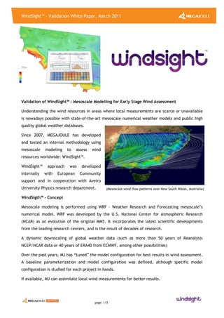
(Wind Map over Portugal in Google Earth kmz format)
(Example of Virtual Wind Index performance against other data sets for a site in Poland)
Why no Pre-Calculated Wind Data ?
Mesoscale weather numerical modeling is a complex science and in constant development.
Calculation domain and several model
parameterizations depend on the site’s
characteristics, latitude and general forcing
weather. The WRF model is also in continuous
development.
By not making use of pre-calculated wind maps or
data MJ ensures that our Clients get the best
modeling option available for each case and at
any given time
Typical application from WindSight™
Typically, mesoscale wind assessment is best suited for greenfield or early stage wind
assessments.
Traditional results are :
• Early stage Wind Resource Mapping (flexible output data – GIS, Google Earth, etc…)
• Early stage micrositing and energy estimates (coupling mesoscale results with WAsP or
CFD)
• Preliminary site assessment (detailed IEC wind conditions by coupling mesoscale results
with CFD)
• Virtual Long Term reference wind data (for Long Term extrapolation and MCP)
Other outputs include Extreme wind speed analysis, Cold Climate or Icing conditions, Hot
Climate conditions.
-100%
-50%
0%
50%
100%
Jan-06 Jul-06 Jan-07 Jul-07 Jan-08 Jul-08 Jan-09 Jul-09 Jan-10
MonthlyWindIndex[%]
NCEP NCAR(1000 mBar) Jasionka Airport(Poland) Local Mast#1 Local Mast#2 Virtual Wind Index](data:image/gif;base64,R0lGODlhAQABAIAAAAAAAP///yH5BAEAAAAALAAAAAABAAEAAAIBRAA7)
Recomendados
Recomendados
Más contenido relacionado
La actualidad más candente
La actualidad más candente (14)
Destacado
Destacado (14)
Similar a WindSight Validation (March 2011)
Similar a WindSight Validation (March 2011) (20)
Último
Último (20)
WindSight Validation (March 2011)
- 1. WindSight™ - Validation White Paper, March 2011 page: 1/5 (Mesoscale wind flow patterns over New South Wales, Australia) Validation of WindSight™ : Mesoscale Modelling for Early Stage Wind Assessment Understanding the wind resources in areas where local measurements are scarce or unavailable is nowadays possible with state-of-the-art mesoscale numerical weather models and public high quality global weather databases. Since 2007, MEGAJOULE has developed and tested an internal methodology using mesoscale modeling to assess wind resources worldwide: WindSight™. WindSight™ approach was developed internally with European Community support and in cooperation with Aveiro University Physics research department. WindSigth™ - Concept Mesoscale modeling is performed using WRF – Weather Research and Forecasting mesoscale’s numerical model. WRF was developed by the U.S. National Center for Atmospheric Research (NCAR) as an evolution of the original MM5. It incorporates the latest scientific developments from the leading research centers, and is the result of decades of research. A dynamic downscaling of global weather data (such as more than 50 years of Reanalysis NCEP/NCAR data or 40 years of ERA40 from ECMWF, among other possibilities) Over the past years, MJ has “tuned” the model configuration for best results in wind assessment. A baseline parameterization and model configuration was defined, although specific model configuration is studied for each project in hands. If available, MJ can assimilate local wind measurements for better results.
- 2. WindSight™ - Validation White Paper, March 2011 page: 2/5 (Wind Map over Portugal in Google Earth kmz format) (Example of Virtual Wind Index performance against other data sets for a site in Poland) Why no Pre-Calculated Wind Data ? Mesoscale weather numerical modeling is a complex science and in constant development. Calculation domain and several model parameterizations depend on the site’s characteristics, latitude and general forcing weather. The WRF model is also in continuous development. By not making use of pre-calculated wind maps or data MJ ensures that our Clients get the best modeling option available for each case and at any given time Typical application from WindSight™ Typically, mesoscale wind assessment is best suited for greenfield or early stage wind assessments. Traditional results are : • Early stage Wind Resource Mapping (flexible output data – GIS, Google Earth, etc…) • Early stage micrositing and energy estimates (coupling mesoscale results with WAsP or CFD) • Preliminary site assessment (detailed IEC wind conditions by coupling mesoscale results with CFD) • Virtual Long Term reference wind data (for Long Term extrapolation and MCP) Other outputs include Extreme wind speed analysis, Cold Climate or Icing conditions, Hot Climate conditions. -100% -50% 0% 50% 100% Jan-06 Jul-06 Jan-07 Jul-07 Jan-08 Jul-08 Jan-09 Jul-09 Jan-10 MonthlyWindIndex[%] NCEP NCAR(1000 mBar) Jasionka Airport(Poland) Local Mast#1 Local Mast#2 Virtual Wind Index
- 3. WindSight™ - Validation White Paper, March 2011 page: 3/5 (Example of Wind Rose and Histogram for a Complex/Inland site, WindSight (grey), Observed (blue))) Validation of Simulated Wind Data Series During 2010 MJ completed its first comprehensive validation programme for WindSight™ mesoscale modeling. The validation was based on the 3x3 km resolution simulated wind data series, based on input data from the global data from NCEP/NCAR Reanalysis I data set. No data assimilation or MOS was performed, to ensure an independent blind test. The simulated data was compared against local measurements for 34 sites in Europe (Portugal, Poland and Romania). The local measurements were taken at lattice masts used for wind assessment fully compliant with IEC/MEASNET requirements. The masts are operated by MJ and are not in anyway assimilated in the input global datasets or in the model runs, thus, ensuring fully independent blind tests. Measurement height ranges is 60 m above ground level for all site but one, with 49 m. The test sites range from flat terrain to complex sites and also from coastal (< 10 km to shoreline) to inland sites. Results showed a RMSE error in average wind speed of 0.76 m/s and a BIAS of - 0.14 m/s. The cumulative distribution of results (table 2) showed that for 80 % of cases, average wind speed difference was below 1.0 m/s and below 0.7 m/s for 50 % of cases. Global statistics for Average Wind Speed comparison MAE (m/s) RMSE (m/s) BIAS (m/s) 0.66 0.76 -0.14 0% 5% 10% 15% 20% N NNE ENE E ESE SSE S SSW WSW W WNW NNW
- 4. WindSight™ - Validation White Paper, March 2011 page: 4/5 Maximum Mean Absolute Error (MAE) for different frequency levels Frequency [%] Maximum MAE (m/s) 50% 0.7 80% 1.0 90% 1.2 Estimated Wind Rose were in good agreement with observations. For 87 % of cases at least one of the 2 predominant wind directions matched the simulated predominant wind directions. For 40 % of the cases, both most predominant wind directions were matched by the simulations. (figure below shows an example for one site). Conclusions The statistics above prove the usefulness of WindSight™ mesoscale wind assessment particularly for greenfield and early stage wind studies. For 3x3 resolution it can be assumed that there is a 80 % probability that real average wind speed will be within +/- 1.0 m/s of simulated average wind speed. Uncertainty in wind speed means that the WindSight™ approach is most applicable for a greenfield or early stage viability studies. At these stages, developers should more willing to take more risk, while benefiting from a pragmatic and comparable approach to wind assessment. Agreement in Wind Rose and Wind Speed Histogram was sufficiently good to provided a good base for early stage turbine micrositing and AEP estimates (coupling mesoscale wind data with micrositing tools and linear or CFD models). This is particularly interesting for projects were wind farm layout must be defined in very early stages and without any local data. Early stage wind assessment, while possible with mesoscale modeling, should never substitute on-site reliable wind measurements for more than 1 year, in order to ensure typical bankable uncertainty on AEP estimates. Further Info.: www.megajoule.pt www.facebook.com/MEGAJOULE www.youtube.com/MEGAJOULEConsultants www.linkedin.com/MEGAJOULE www.twitter.com/MEGAJOULE megajoule@megajoule.pt
- 5. WindSight™ - Validation White Paper, March 2011 page: 5/5 Annex - List of sample sites ID Complexity Elevation [m] Average Wind Speed [m/s] Deviation [m/s] Observed Simulated 1 Complex / Inland 698 5.86 6.45 0.59 2 Complex / Inland 777 6.56 7.30 0.74 3 Complex / Inland 890 7.47 7.93 0.46 4 Complex / Inland 892 7.87 7.85 -0.02 5 Complex / Inland 775 6.87 7.58 0.71 6 Complex / Inland 1067 8.97 8.20 -0.77 7 Complex / Inland 993 8.35 8.43 0.08 8 Complex / Inland 456 6.46 6.56 0.10 9 Complex / Coastal 990 8.50 9.05 0.55 10 Complex / Inland 397 8.08 7.16 -0.92 11 Complex / Inland 443 8.93 7.36 -1.57 12 Complex / Coastal 522 8.96 8.30 -0.66 13 Complex / Inland 410 8.00 8.91 0.91 14 Complex / Coastal 567 8.66 8.12 -0.54 15 Flat / Coastal 60 6.07 5.35 -0.72 16 Flat / Inland 67 6.19 5.43 -0.76 17 Flat / Inland 372 7.19 6.60 -0.59 18 Flat / Inland 3 5.40 5.30 -0.10 19 Flat / Coastal 112 6.41 5.68 -0.73 20 Flat / Coastal 204 7.00 5.75 -1.25 21 Flat / Inland 78 6.70 5.63 -1.07 22 Flat / Inland 119 6.01 5.52 -0.49 23 Flat / Coastal 70 6.15 5.88 -0.27 24 Flat / Inland 132 5.97 5.26 -0.71 25 Flat / Inland 273 6.60 6.21 -0.39 26 Flat / Inland 142 6.51 5.58 -0.93 27 Flat / Coastal 162 6.38 5.48 -0.90 28 Flat / Coastal 109 5.78 5.69 -0.09 29 Complex / Inland 393 5.78 7.07 1.29 30 Complex / Inland 445 6.17 7.32 1.15 31 Complex / Inland 435 6.59 7.02 0.43 32 Complex / Inland 575 7.16 6.98 -0.18 33 Flat / Inland 240 6.17 6.93 0.76 34 Complex / Inland 422 5.72 6.86 1.14