SlideShare una empresa de Scribd logo
1 de 11
Application of Structure-Index Technique to Detect Soil Degradation

           Mohamed Fahmy HUSSEIN* , Salah El-AMIR* and Essam RAMADAN* *

*      Cairo University, Faculty of Agric., Soil and Water Dept., Egypt
**     Ministry of Agriculture, Cairo, Egypt

                                                 Abstract
      Aggregate stability in fine-textured soils is a guarantee of good yield. A Structure-Index
technique was applied to 70 layers of 14 profiles in the Nile Delta Apex, north of Cairo, Egypt; in
an environment that was traditionally considered as one of the most precious soils of the country.
      The used index depends on three fluid treatments: 1- Alcohol followed by water, 2- Benzene
then water, and 3- Water alone. The pre-Alcohol treatment leads to increasing aggregate stability,
the pre-Benzene treatment puts an extra-explosive power to aggregate destruction, whereas the
Water alone treatment is somewhere between these two organic-fluid actions.
      Water regime, chemistry and water table depth closely relate to the structure of heavy-textured
flat irrigated-lands. The Nile Delta, prior to application of perennial irrigation 150years ago, was
historically under basin-irrigation thanks to the annual Nile flood and the endeavor of the Egyptian
farmers who well managed the extra-extensive basins in Upper and Lower Egypt for thousands of
years. The State has introduced tile drainage 20 years ago in the study area.
      We observed (through time-series model applied to Tritium data of the semi-confined Delta
aquifer) that recharge of 100mm.year-1 of the semi-confined aquifer has resulted in a piezometric-
level rise of 10m during the last century. The water table of the unconfined aquifer is ~1m below
soil-surface at present.
      SI data showed degradation of soil-structure in most bottom and some upper layers of half the
studied profiles. The data show that SI values are in the range 2–12 for the studied area. Linear
(EC–SI) and (ESP–SI) relationships are obtained. The slope of the (EC–SI) line is higher than that
of the (ESP–SI) indicating structure degradation with early salinity increase. Negative regression is
observed between SI and Ksat.
      The index is easily realizable and gives meaningful indication on soil structure when related to
other soil parameters. The assessed index is believed suitable for soil-conservation projects.

     Introduction
      The agricultural plant yield is largely affected by soil-structure, in particular in the heavy-
textured lands. Soil-structure is the outcome of the factors affecting soil status setup. Soil-structure
is a dynamic property that may be improved or degraded. It might be improved through good
management procedures (among which the irrigation application-rate and water-quality stand as the
most-important aspects in the irrigated-lands). Soil-structure can be studied in the field (by
morphologically describing the size, form, configuration and orientation of peds), in the lab (on
microscopic-scale in thin sections) and through physical techniques, including wet-sieving and
aggregate-size distribution methods. However, soil-structure might be represented by a single-
parameter that may be useful for quick assessment.
      A simple and rapid method for the evaluation of an easy-to-use “Structure-Index, SI” is needed
for recognizing structure change with depth in the same profile and matching-up several profiles in
a given landscape. No field-instrument is available for providing a structure-index value. Only lab
determinations are applicable. As long as the lab method is readily used, coherent results could be
obtained and interpreted. Tedious methods are not encouraging and may impose difficulties for the
treatment of large number of samples in short time. This work presents an appraisal of a new
structure-index as used for the evaluation of soil-structure in a large number of soil-materials
sampled from clayey soils in the south of the Nile Delta, Egypt.
Figure1. Location map

    Review of Literature
     Aggregation is the product of chemical interaction among organic and inorganic soils particles
(Edward and Bremner, 1967). Stable aggregates are internally held by chemical bonds that resist
disintegration in water. Harris et al. (1966) summarized theories explaining the chemical processes
involved in soil aggregation. The mechanisms include: (1) linkage of clay particles by water
dipoles, (2) cross-bridging and sharing of inter-crystalline forces (due to exchangeable cations)
between clay-particles, (3) envelopment of soil particles by precipitated and irreversibly-dehydrated
colloids (silicates, sesquioxides and humates), (4) presence of hydrophobic organic materials, and
5) inter-particle linkage by organic polymers that form bonds (through functional groups) with the
surface of two or more clay plates.
     The role of microbial activity on soil-aggregation has been studied by Gasperi-Mago and Troeh
(1979) and appears to affect soil-aggregation in three ways: (1) filaments of microbial tissue may
form a network within and around mineral particles, (2) certain soil microorganisms produce
polysaccharides that have a mucilaginous nature and may cement mineral particles, and (3)
microorganisms produce non-polysaccharide organic residues of various kinds that may help in
binding mineral particles (Gabriels and De Boodt, 1976). Soil-aggregation is influenced by agro-
technical practices such as tillage and can be improved by appropriate tillage at optimal moisture
content. Hussein (1975) observed that the Structure Factor (SF) decreases in saline clayey soils in
the north of the Nile Delta. The clay particles deflocculated in water were 5% in surface layers and
up to 46% at 100-150cm depth, and SF decreased with salinity increase mainly due to the sodium
ion impact.
     Oades (1984) showed that the stability of pores and particles is essential for optimum growth
of plants. Two categories of aggregates macro- (>250µm) and micro- (<250µm) depend on organic
matter for aggregate stability. Dispersion of clay particles from micro-aggregates is promoted by
adsorption of organic acids, which increase the negative charge on clays. However, the
dispensability of clay in micro-aggregates is offset by the binding action of polysaccharides, mainly
mucilage produced by bacteria, but also by plant roots and fungal hyphae. Micro-aggregates
                                                 2
stability is enhanced by multivalent cations, which act as bridges between organic colloids and
clays. Macro-aggregates are enmeshed by plant roots, both living and decomposing, are thus
sensitive to management, and increase in number when grasses are grown in the concerned fields.
     Diaz-Zoritaa, et al (2002) reported that soil structure is the arrangement of primary soil
particles into hierarchical units identified based on failure zones. The description and quantification
of soil structure is important since many agronomic and environmental processes are related to the
arrangement of secondary aggregates, peds or clods and their stability. The size of fragments is
inversely related to the mechanical stress applied. It is useful to characterize the fragment mass-size
distribution with parameters from a model, such as the lognormal distribution function. The fractal
theory provides a physically based link between the size distribution and stability of fragments.
Structural stability is based on the ratio of fragment mass-sizes measured before and after low and
high mechanical stresses, respectively.
     Denef, et al, (2003) illustrated that cultivation will result in reduced stability and amount of
macro-aggregates but does not affect micro-aggregate stability. Eynard, A., et al, (2004) illustrated
that structure stability often decreases with the intensity of cultivation. Marquez, C. O., et al (2004)
showed a theoretical and experimental framework that permits an accurate determination of
aggregate-size stability. The determination of aggregate-size stability distribution involves the
assumptions that soil aggregates can be categorized in terms of their size and water stability
(slaking resistance). The stable aggregates index (SAI) and the stable macro-aggregates index
(SMaI) were proposed for studying soil stability based on aggregate resistance to slaking. These
indices account for the total weighted average of stable aggregates and the total weighted average of
stable macro-aggregates, respectively. Both the SAI and the SMaI indices were shown to be
sensitive to the effect of vegetation on soil stability. These indices were higher in surface soils
under cool-season grass than any other treatment.

    Materials and Methods
     Fourteen soil profiles, as well as five surface-soil layers, irrigation-water, groundwater and
drainage- water samples were collected for an extensive environmental soil study of the Nile Delta
apex, Egypt. The study area (Figure 1) has clayey soils, moderately shallow profiles (down to the
piezometric surface of the unconfined aquifer) standing at about 1m below soil surface. That region
was historically known for having good soils, low salt-content, free of sodicity and producing fine
yields. However, serious changes have taken place during the last century due to water-regime
change related to the shift from basin-irrigation to perennial-irrigation and the consequent
development of shallow water table by over-recharge of Delta aquifer.

                        Table1 Maximum and minimum values for some data

                          ESP    ECaP EMgP             EKP      CEC Clay% K, cm/hr          S.I.
     MAX                   32.21  64.78 40.32            8.33    48.85 54.78  1.470          11.52
     MIN                    3.57  39.50 18.89            0.92    29.11 34.99  0.002           1.68
     ratio MAX/MIN          9.03   1.64  2.14            9.08     1.68  1.57 735.00           6.86

     ESP     =       Exchangeable Sodium%
     ECaP    =       Exchangeable Calcium%,
     EMgP    =       Exchangeable Magnesium%
     EKP     =       Exchangeable Potassium%
     CEC     =       Cation Exchange Capacity, meq/100 gram
     K               =      Hydraulic Conductivity (Saturated)
     SI      =       Structure Index


                                                   3
Reconstructed Tritium Content in Nile water

                        1000
                                                                 (425) an excluded
                                                                       value

                         100                                                                                                    Fahmy & R.Michel
                                                                                                                                Old model
                   TU
                                                                                                                                measured
                             10                                                                                                 precipitation


                             1
                              1950          1960            1970            1980              1990               2000
                                                                    Years

Figure2. Tritium prediction model and data for the Nile water in both its head-reaches and in Egypt

     1                                                                                1
     2                                              Profile 1                         2                                                Profile 1
     3                                                                                3
     4                                                                                4
     5                                                                                5
     6
     7
                                                    Profile 2                         6
                                                                                      7
                                                                                                                                       Profile 2
     8                                                                                8
     9                                                                                9
    10                                                                               10
    11                                              Profile 3                        11                                                Profile 3
    12                                                                               12
    13                                                                               13
    14                                                                               14
    15                                                                               15
    16                                              Profile 4                        16                                                Profile 4
    17                                                                               17                                                                 index
    18                                                               Alchol          18
    19                                                                               19                                                                 lowest
    20                                                               Water           20
    21                                              Profile 5                        21                                                Profile 5        highest
    22                                                               Benzine         22
    23                                                                               23                                                                 mean
    24                                                                               24
    25                                                                               25
    26                                              Profile 6                        26                                                Profile 6
    27                                                                               27
    28                                                                               28
    29                                                                               29
    30                                                                               30
    31                                              Profile 7                        31                                                Profile 7
    32                                                                               32
    33                                                                               33
    34                                                                               34
    35                                                                               35
    36                                              Profile 8                        36                                                Profile 8
    37                                                                               37
    38                                                                               38
    39                                                                               39
    40                                                                               40
    41                                              Profile 9                        41                                                Profile 9
                                                                               m


    42                                                                               42
                                                                               p
                                                                               b
                                                                               u
                                                                               n
                                                                               S
                                                                               o
                                                                               a
                                                                               r
                                                                               e
                                                                               s
                                                                               f
                                                                               l
                                                                               i
m


    43                                                                               43
p
b
u
n
S
o
a
r
e
s
f
l
i


    44                                                                               44
    45                                                                               45
    46                                            Profile 10                         46                                               Profile 10
    47                                                                               47
    48                                                                               48
    49                                                                               49
    50                                             Profile 11                        50                                               Profile 11
    51                                                                               51
    52                                                                               52
    53                                                                               53
    54                                                                               54
    55                                            Profile 12                         55                                               Profile 12
    56                                                                               56
    57                                                                               57
    58                                                                               58
    59                                                                               59
    60                                                                               60
    61                                            Profile 13                         61                                               Profile 13
    62                                                                               62
    63                                                                               63
    64                                                                               64
    65                                                                               65
    66                                            Profile 14                         66                                               Profile 14
    67                                                                               67
    68                                                                               68
    69                                                                               69
    70                                                                               70
         0    10        20        30   40    50       60    70                            0    1     2   3   4     5    6   7     8   9   10 11    12
                    Stable aggregates, %                                                                     Structure index
    (the data-points representing the 5 surfac-layer samples                                  (low = stable structure, high = poor stucture)
     are shown by triangle, orthogonal and squar symbols)
Figure3. (Left) The sampled-layers are arranged in a (1-70) series and the three treatments are compared
Figure4. (Right) The structure-index values are compared. The lowest, highest and mean values are shown. Four
profiles (#1, 2, 8 and 11) have low values (2-5) (fully-good structure), seven profiles (# 3, 4, 7, 10, 12, 13 and 14) have
moderate values (<8) (sensible-structure), and three profile (#5, 6 an 9) have high index-values (~12) (poor structure)


                                                                               4
It is suspected that 150years of perennial irrigation applied without adequate field drainage has
imposed negative impact on the soil environment of the studied area. Tile drainage has been
introduced 20years ago. The study area was functioning for thousands of years under the annual
rhythm of once-per-year basin-irrigation water administration. That ancient water-regime was the
direct result of the annual Nile flood into Egypt and the effort of Egyptian farmers who renewed
and maintained, for thousands of years, the large-scale irrigation basins before each flood-season.
     Using a Tritium time-series data-set and curve-fitness exponential and dispersion models
(Hussein, 1995) it is has been shown, Hussein et al, (1998) and Figure 2, that after the introduction
of the perennial irrigation system, by the mid of the 19th century, the Delta aquifer became victim of
over-recharge (up to 100mm/year) through non-point seepage from the cultivated fields (due to
excessive irrigation water-application) and point seepage from irrigation-canals. Perennial irrigation
allowed the cultivation of all the Nilotic land of Egypt the year-round. However, the water table
was ~10m below soil-surface (150 years ago) whereas it is about ~1m at present. This recharge has
increased aquifer storage by 200*109m3 under the Nile Delta (~22*103 km2 in area.)
     This sharp change in soil-water regime has accompanied the introduction of perennial
irrigation and resulted elsewhere in the Nilotic Egypt, Hussein et al, (1998), in soil degradation.
That degradation was mainly attributed to water-table rise (Hussein et al, 1998, 1999 and 2001 and
Mohamed Fahmy Hussein, 2001). To conserve soil and to prevent environmental degradation, a
huge tile-drainage project was initiated 20 years ago and should be accomplished by the year 2017.
However, the maintenance of the installed tile-network continually seems a difficult task.
     The present work is concerned with soil-structure and its relation to soil-behavior in the study
area. A host environmental study will be published elsewhere. A new technique, based on fluid
treatment, is applied on seventy soil samples, from14 profiles as well as five surface-soil samples,
in the Monofieyah Governorate at the Nile Delta apex north of Cairo, for the evaluation of the new
index. The results are shown in Figures 3-12. Three five air-dry gram masses of each soil sample
were treated as follows according to the “structure-index” of Mounier G., (1994): 1) Ethyl alcohol,
followed by water, 2) Benzene then water, and 3) Water alone. Three sets of stable aggregates are
obtained for each sample and a single parameter (structure-index, SI) is derived.
     The purpose of adding organic fluids (Ethyl Alcohol or Benzene) is to slow-down water-
imbibition into soil aggregates. Ethyl alcohol completely mixes with water; it does not decrease
cohesion; instead, it artificially increases aggregate-stability (due to air-escape without destroying
the aggregates, so when water is subsequently added the aggregates do not suddenly explode.
Consequently, the poor-structured soils may be compared). Benzene is, on the contrary, a non-polar
and uncompressible fluid that does not mix with water. When water is next added, it pressurizes the
Benzene entrapped into soil-pores, so the aggregates abruptly explode and only the very stable
aggregates persist. Benzene is used for soils poor in organic-matter in order to increase the
destructive power of water. In the case of organic-matter rich soils, Benzene will be fixed (on the
O.M.) and aggregate-stability will not be affected; rather a gradual distribution of the structure-
index will be obtained. Benzene application is usually used to study soils with O.M. of different
origins. Adding water without previous treatment decreases cohesion so air is entrapped and
aggregates readily explode. The formula used for the “structure index” (Mounier G., 1994) is:

                                               highest (silt+clay) ratio in 3 treatments
         Structure index =
                             mean (stable aggregates+coarse sand) ratio in 3 treatments - (0.9 * C.S. ratio)

     The C.S. ratio is the coarse sand percentage in soil sample (determined according to the regular
particle-size distribution lab procedure). The factor 0.9 is believed to slightly increasing the
denominator in order to approach soil structure status under field conditions. When this formula
produces a high value, this indicates soil structure deterioration.


    Observations and Interpretation
                                                     5
Figure 1 demonstrates the study area. Figure 3 is shows the lowest percentages of stable-
aggregates for the Benzene-treatment. These low percentages (min=0.8%, max=11% – with one
exception of 19.8% for the surface layer of profile 5, sample #21,) represent the highly stable
aggregates. The Alcohol-treatment has exaggerated the stable aggregates (min=16.4%,
max=64.2%). The water only treatment (min=3.8%, max=33.4%) is between the Benzene and the
Alcohol treatments. These observations show that the “three-fold-fluid treatment” is working fine.
      This single-parameter structure indicator is shown in Figures 3, 4 and 5 for the studied profiles.
Each time the sable aggregates (Figure 3) decreases the structure-index (Figure 4) increases. Three
profiles (# 2, 8 and 11) generally have low index-values (from ~2 to ~4) that reflect good structure.
Eight profiles (#1, 3, 4, 7, 10, 12, 13 and 14) have moderate index-values (from ~3 to ~6) in most
layers reflecting moderate to sensible structure, and three profiles (#5. 6 an 9) have moderate to
high index-values (from ~4 to ~12) reflecting a mixture of sensible and poor structure.
      Some profiles (# 1, 5, 10, 11 and 12), Figures 4 and 5, have high index-values in the bottom
layers, whereas other profiles (# 3, 7, 9 and 14) have high index-values also at the soil surface.
Profiles #2, 4, and 6, 8, 13 have index-values oscillating between relatively low to relatively high
throughout the sampled depths. Generally, it seems that soil degradation in the study area generally
starts at profile bottom through contact with the water table, reception of the leachate from the
upper layers and by the over-burden stresses.
      According to the obtained Structure-Index values, we introduce the following limits: (2-4%),
(4-6%), (6-8%) and (8-12%) for the following four categories: Good, Moderate, Sensible and Poor
structure, respectively.
      We used unpublished data, Hussein (1975), for soil structure evaluation of soils in the north of
the Nile Delta using the structure-factor (SF) method where only water was used to determine the
deflocculated clay percent. We calculated the term [(1/SF)*100]. A general trend of the increase of
this term with depth is observed (Figure 6) with some exceptions. The structure-factor has a
curvilinear relationship with the ESP (not shown) whereas the inverse term [(1/SF)*100] has a
linear relationship with ESP (Figure 8). It seems that the structure-index method is more reliable
and sensitive to show slight changes in soil structure than the structure-factor method; may be due
to the implication of three fluids in the structure-index technique and its improved formula.
      The relationship of the structure-index, SI, with the ESP, Figure 7, is showing a linear positive
trend (with the increase of the ESP, soil structure is degraded as shown by the increase of the SI
value). However, the scatter is high; may be because ESP is just a factor, among others, affecting
structure status. The scatter of data-points sharply increases when the ESP surpasses 15%. The
relationship of SI with EC, Figure 9, is showing that the SI value increases with salinity increase.
The scatter of data-points becomes high starting from EC of 4dS/m. When EC surpasses 16dS/m
(not shown) the SI value decreases (apparent amelioration of structure probably due to excessive
soluble salt-content that enhances cohesion of soil material). It is to be noticed that the very early
increase in soil salinity produces rapid structure degradation. Nonetheless, neither salinity (EC)
alone nor ESP alone, nor the two together, could be separately considered in data interpretation.
The effect of these two factors could be understood in the general context of the drying-wetting
cycles affecting soil moisture, irrigation intervals and chemical composition of soil-solution and all
the other factors that may affect soil aggregation, including the microbial activity, temperature
changes, degasing of soil air, O.M. content and composition, cultivation, management etc… since
all these factors are continuously acting on the destruction and/or the reconstruction of stable
aggregates, in the soil space- and time- continuum.
      The linear increase of the ln ESP with ln EC (Figure 10) is a common observation in the salt-
affected soils. In that diagram we used non-published data (Hussein, 1975) and the wide-range of
values is better appreciated through ln-transformation. The exchangeable (E”Ca+Mg”P), Figure 11,
has a very sharp slope in the linear relationship with ESP, whereas the other exchangeable cations
(ECaP, EMgP and EKP) have a less acute slope, a moderate slope and a very week slope,
respectively. It is obvious that exchangeable Ca is the cation preferentially replaced by Na in these
chemically deteriorated soils, followed by the exchangeable Mg. The CEC is weekly related to clay

                                                   6
content (not shown) probably due to the dominance of clay-mineral type over clay content. The
ESP is very weekly related to both clay percentage and CEC (not shown). Seemingly, this reflects
that the relationship of these variables with the ESP is more defined by clay mineralogy (affecting
the state of the diffuse electrical double-layer and the zeta potential) rather than by anything else.
     The log-transformation of (Ksat-ESP) data, Figure 12, resulted in improvement of the linear
relationship. In the (logKsat-logESP) plot, linearity is shown with a strong scatter. A negative linear
trend is obtained for the (logKsat-log SI) relationship, Figure 12. The high scatter says that the Ksat,
ESP and SI values are affected by several factors, so a single relationship is a part of a complicated
setup that cannot be defined by any single factor. Table 1 gives summary of the upper and lower
limits of data. The values of Ksat have the highest ratio of the upper/lower limits (700 times). The
ratio of the upper/lower limits for ESP and SI is comparable (nine and seven times, respectively.)


Figure5. (Upper) Fourteen profiles are compared according to the structure-index values
Figure6. (Lower) Five profiles are compared with respect to the inverse of the structure factor, (1/SF) *100

                        12
                        10       y = 0.124x + 2.696                                20
                                     R² = 0.243                                              y = 0.167x + 0.044
                        8                                                          15            R² = 0.401
            Structure   6                                                   (1/SF ) 10
              index                                                          *100 5
                        4
                        2                                                           0
                        0                                                                0      10    20    30    40   50
                             0       5     10    15     20   25   30   35
                                                                                                           ESP
                                                      ESP

Figure7. (Left) The relationship of structure-index with ESP; scatter increases when ESP surpasses 15%
Figure8. (Right) [(1/SF)*100] increases with ESP increase


                                                                       7
12                                                                       4.5
                                                                                               4.0          y = 0.482x + 1.921
                      10                    y = 0.295x + 3.250                                                  R² = 0.579
                                                R² = 0.233                                     3.5
                       8                                                                                                                this work
                                                                                               3.0
          Structure    6                                                              ln ESP   2.5
            index                                                                              2.0                                      unpublished
                       4
                                                                                               1.5                                      data
                       2                                                                       1.0                                      linear fit
                       0                                                                       0.5
                             0     2    4     6       8   10     12   14     16                      -0.5 0.0   0.5   1.0   1.5   2.0

                                             EC, dS.m-1                                                     ln EC, dS.m-1

Figure9. (Left) Relationship of the structure index with EC
Figure10. (Right) Relationship between ESP and EC is shown by ln-transformation

                                               100
                                                90
                                                80
                                                70                                               X = Ca+Mg
                                                60                                               regr. (ECa+MgP)-ESP
                                            EXP 50                                               X = Ca
                                                40                                               regr. ECaP-ESP
                                                30                                               X = Mg
                                                20                                               regr. EMgP-ESP
                                                                                                 X=K
                                                10
                                                                                                 regr. EKP-ESP
                                                 0
                                                          0      20 40 60 80 100
                                                                     ESP
Figure11. Regressions of exchangeable cations. The slope of (EMgP-ESP) is one-third of that of (ESP-ECaP). The
slope of (EKP-ESP) is 0.08 of that of (ESP-ECaP)

                   1.0                                                                         1.0
                   0.0                                                                      0.0
             log
                  -1.0                                                                log
             Ksat                                                                          -1.0
                  -2.0                                                                Ksat
                  -3.0                                                                     -2.0
                             0.5            1.0           1.5              2.0             -3.0
                                               log ESP                                                0.0             0.5        1.0
                 this work         unpublished data       all     Linear (all)
                                                                                                                log structure index

Figure12 Log-transformations show decrease of (log K sat) with both (log ESP) and (log structure-index) increase

     Conclusions
     A new single-parameter indicator (the structure index, SI) was applied on 70 soil materials and
proved informative and sensitive to soil structure status. The technique is simple, elegant and can be
used on a routine-basis for soil conservation purposes. Soil degradation has several reasons. One of
the most outstanding reasons for the alluvial soils in Egypt is related to water-table rise in the
unconfined aquifer during the last 150years of perennial irrigation practice without installation of
field-drainage network until 20years ago. Consequently, the over-recharge of the Delta semi-
confined aquifer has taken place and manifested in rise of piezometric level of the upper
(unconfined) aquifer. The present-day water-table level is below soil surface by ~1m (instead of
10m by the mid of the 19th century). The direct result of such situation is the increase of salt-content
and development of high ESP. So, soil became under increasing chemical stresses that lead to
deterioration of yield amount and quality. The obtained data show a positive linear relationship
between EC and the ESP. The values of that structure index also illustrate positive linear
relationships between the SI-values and both of the EC and the ESP. The SI surpasses the old
(structure-factor) parameter in sensitivity. It is recommended to use the SI as a lab routine as it is
successful for detecting soil structure degradation in its early and moderate stages.

                                                                                  8
References
Denef, K., J. Six, R. Merckx, and K. Paustian. 2003. Carbon sequestration in micro-aggregates of no-tillage soils with
   different clay mineralogy. Soil Sci. Soc. Am. J. 68:1935–1944
Diaz-Zoritaa,b, M., E. Perfect and J. H. Grove. 2002. Disruptive methods for assessing soil structure.
   Elsevier Science, 254-9
Edwards, A.P., and J.M. Bremner. 1967. Micro-aggregates in soils. J. Soil Sci. 18: 47-63.
Eynard, A., T. E. Schumacher, M. J. Lindstrom, and D. D. Malo. 2004. Aggregate sizes and stability in cultivated south
   Dakota prairie Ustolls and Usterts. Soil Sci. Soc. Am. J. 68:1360–1365
Gabriels, D., and M. De Boodt. 1976 Report on the use of petroleum products for soil structure modification and soil
   conservation. Soil Physics lab, Rijks Univ. Gent.
Gasperi-Mago, R.R., and F.R. Troeh. 1979. Microbial effects on soil erodibility. Soil Sci. Soc. Am. J. 43: 765-768.
Harris, R.F., 6. Chester, and O.N. Alien. 1966. Dynamics of soil aggregation. Adv. Agron. 18: 107-169.
Hussein, M. F, 1975.
   Morphological, physical and chemical changes associated with salinization process in Egyptian Alluvial Soils.
   M.Sc. Thesis, Cairo Univ., Fac. of Agric, Soil and Water Dept. 171p.
Hussein, M. F. 1995.
   ”RIETHM”: Radioisotope environmental tracer hydrology model using the exponential and dispersion methods. In:
   First International Symposium on “Application of Tracers in Arid Zone Hydrology”, IAEA-IHA, Vienna, 15-26
   August 1994. IAHS Publ. N. 232, 1995, Proceedings of the Vienna Symposium, August 1994, 211-224.
Hussein, M. Fahmy and Michel, R. L., Froehlich, K. 1998.
   Historical isotopic changes in the River Nile and their relation to the study of ground-water hydrology of the Nile
   Valley and Delta. In: Gambling with Groundwater: Physical, Chemical, and Biological Aspects of Aquifer-Stream
   Relationships. International Association of Hydro-geologists. XXVIII Congress and Annual Meeting of the
   American Institute of Hydrology, Las Vegas, Nevada, USA. September 27-October 2, 1998, 105-110.
Hussein, M. F., Frohlich, K., Nada, A., Atta, S.A. and Tanweer, A., 1998. Environmental isotopes and hydrochemistry
   of ground water in west El-Fashn and Maghagha regions, Isotope & Rad. Res., 30, 1-10.
Hussein, M. Fahmy, Michel, R. L., Nada A., Froehlich, K., Atta, S. and Tanweer, A. 1999.
    Use of isotope geochemistry to determine the effectiveness of water management strategies, Nile valley, Egypt. In:
    International Symposium on Isotope Techniques in Water Resources Development and Management. Book of
    Extended Synopses, IAEA-SM-361, Vienna, Austria, 10-14 May 1999, pp 63-69.
Hussein, M F, Fröehlich, K. and Nada A. 2001.
    Environmental isotope profiles and evaporation in shallow water-table soils. In: Isotope techniques in water
    resources investigations in arid and semi-arid regions, IAEA CRP 303-F3-Egy–7902/RB, IAEA-TECDOC-1207,
    March 2001, 27-31.
Marquez, C. O., V. J. Garcia, C. A. Cambardella, R. C. Schultz, and T. M. Isenhart. 2004. Aggregate-size stability
   distribution and soil stability. Soil Sci. Soc. Am. J. 68:725–735
Mohamed Fahmy Hussein, 2001. Monitoring land and water degradation: Environmental dimensions and restoration.
   Sym. Nat. Res. & Their Conservation in Egypt & Africa, Inst. African Res. & Stud., Cairo Univ., 19-21 November
   2001, 474-495
Monnier G. 1994. Assemblage et Organisation Physique des Particules.. In : Bonneua Maurice et Souchier Bernard
   (editors). Pédologie, Part 2. Constituants et Propriétés du sol, 2nd Edition, Masson, Paris, Milan and Barcelone,
   665p (la méthode analytique de l'indice structural, page 346).
Oades, J. M. 1984. Soil organic-matter and structural stability: mechanisms and implications for management. Plant and
   Soil 76, 319-337


                                                          9
‫فحص تقنية دليل بناء ‪Structure Index‬جديد لرصد تدهور الراضى‬
         ‫**‬
           ‫أ . د . محمد فهمى حسين* ، أ .د . صلح المير* ، م . عصام رمضان‬
                                               ‫جامعة القاهرة ، كلية الزراعة ، قسم الراضى والمياه ، القاهرة ، مصر‬       ‫*‬
                                                                                  ‫وزارة الزراعة ، القاهرة ، مصر‬       ‫**‬
                                                       ‫ملخص‬
     ‫تعتبر وفرة التجمعات البنائية الثابتة بالراضى ناعمة القوام ضمان ً أساسي ً لرفع جودة وانتاجية المحصولت‬
                                 ‫ة‬       ‫ة‬
‫الزراعية . استخدمنا تقنية "دليل بناء" جديد لتمحيصه كدليل يوضح حالة البناء فى أرا ٍ ُعتقد أنها تعرضت للتدهور بفعل‬
                            ‫ضي‬
     ‫تغيير نظامها المائى . أجرينا العمل على سبعين عينة تربة رسوبية نهرية طينية-القوام من أربعة عشر قطاع ً وخمسة‬
           ‫ا‬
‫عينات سطحية بجنوب دلتا النيل، 05كم شمال القاهرة، بالقرب من نيل دمياط ، بمحافظة المنوفية، مصر، بمنطقة كانت تعد -‬
                                                                         ‫لزمن ضارب فى ال ِدم - من أجود أراضى البلد .‬
                                                                                                   ‫ق‬
‫ُقدم هذا العمل نتائج الختبار المعملى لهذا المدليل . حصلنا على رقم الدليل بتنفيذ ثلث معاملت على كل عينة : )‬
                                                                                                         ‫ي‬
  ‫1- إضافة كحول ثم ماء ، 2- إضافة بنزين ثم ماء ، 3- المعاملة بالماء فقط( . تؤدى المعاملة المسبقة بالكحول إلى تعظيم‬
        ‫مصطنع لثبات التجمعات، فى حين تؤدى المعاملة بالبنزين دورً عكسي ً )هو التحطيم الجائر للبناء، فل يتبقى سوى‬
                                                ‫ا‬      ‫ا‬
‫التجمعات الشد ثبات ً (، وتقع المعالجة بالماء فقط بمكان ما بين المعالجتين بهذين السائلين العضويين . وكلما زاد رقم الدليل‬
                                                                                                   ‫ا‬
                                                                                              ‫دل ذلك على تدهور البناء .‬
 ‫أوضحت البيانات وجود تدهور ملحوظ بالبناء فى نحو نصف عدد القطاعات محل الدراسة، حتى بالطبقات العليا، ل‬
     ‫السفلى فقط . وظهر أن (دليل البناء) محل الدراسة ل يمتاز فقط بسهولة تنفيذه لمقارنة عدد كبير من العينات فى وقت‬
   ‫قصير، بل أنه يعطى دللة أوضح من التى يعطيها (معامل البناء) التقليدى، كما يمكننا ربط هذا المؤشر الجديد بغيره من‬
 ‫المتغيرات – كتملح وصودية التربة وتوصيلها الهيدروليكى المشبع – وهذا أمر هام، لما لتلك المتغيرات من علقة مباشرة‬
     ‫بتدهور البناء بفعل التغيرات البيئية،كما يتسنى ادخال رقم هذا المؤشر – كدليل منفرد – ضمن المعالجة رقمية لقواعد‬
 ‫بيانات الراضى، وربما يمكن استخدامه لحق ً فى النمذجة الفيزيائية والكيميائية وللمحاكاة الرياضية للراضى على الحاسب‬
                                                                        ‫ا‬
                                                                                                                   ‫اللى .‬
      ‫يرتبط بناء الراضى ثقيلة-القوام ارتباط ً وثيق ً بدينامية قطاع التربة )خصوص ً نظامه المائى وكيمياء المياه‬
                                  ‫ا‬                            ‫ا‬      ‫ا‬
‫السطحية والجوفية( . لقد كانت دلتا النيل، قبل تعميم الرى الدائم بالراضى الرسوبية النهرية بمصر – منذ نحو 0٥1عام ً –‬
  ‫ا‬
  ‫خاضعة طوال تاريخ الزراعة المصرية للف السنين للرى الحوضى، بفضل فيضان النيل ونشاط الفلح المصرى الذى كلن‬
  ‫يصون ويدعم جسور الحواض الضخمة كل عام . وللسف لم يتم تعميم الصرف الحقلى المغطى بالدلتا سوى مؤخرً )منذ‬
       ‫ا‬
                    ‫نحو 02 عام ً (، فى حين تبدل النطام المائى للتربة، بشدة بفعل الرى المستديم، منذ نحو قرن ونصف .‬
                                                                                                     ‫ا‬
    ‫لوحظ – بتطبيق مودبل مناسب على متسلسلة زمنية لبيانات التريتيوم كنظير بيئى طبيعى مشع بالمياه الجوفية‬
  ‫بدلتل النيل – أن الشحن الذى كان يتلقاه الخزان الجوفى السفلى )شبه-المحصور( قد ناهز 001مم/سنة )فى غيبة الصرف‬
‫الحقلى طوال 0٢1عام ً(، مما أدى لرتفاع منسوب المياه بنحو عشرة أمتار بالخزان الجوفى )حر-السطح( الذى يعلو الخزان‬
                                                                                         ‫ا‬
   ‫السفلى )شبه-المحصور(، عما كان عليه الحال قبل 0٥1عام ً )بمعنى أن الماء ربما كان على عمق عشرة أمتار فأصبح ل‬
                                                       ‫ا‬
    ‫يتجاوز نحو متر واحد تحت سطح التربة حالي ً (، وإذا كان ذلك الشحن الجائر قد استمر لكان قد نشأ عنه ارتفاع منسوب‬
                                                                       ‫ا‬
‫المياه الجوفية بنحو متر آخر خلل عشرة أعوام، مما كان سيعنى تحول دلتا النيل بالكامل إلى مستنقعات غدقة منذ نحو عقد‬
                                                                                                             ‫من الزمان .‬
      ‫لحظنا ارتباط قيم دليل البناء )‪ (SI‬بتملح الترية )‪ (EC‬والصودية )‪ (ESP‬خطي ً ، وإن كانت نقاط البيانات فى‬
                                  ‫ا‬
‫العلقتبن )‪ (SI-EC‬و)‪ (SI-ESP‬عالية التبعثر خصوص ً بالمراحل المتأخرة من تزايد التملح والصودية . وكان ميل الخط )‪SI‬‬
                                                               ‫ا‬
 ‫‪ (-EC‬أكبر من ميل الخط )‪ ،(SI-ESP‬مما يعنى أن تدهور التربة يظهر بمجرد بدء تملحها، أى قبل تحولها لر ٍ صودية ،‬
         ‫ض‬

                                                          ‫01‬
‫ولحظنا أن تزايد التملح عن 61‪ dS/m‬قد أدى لنخفاض رقم الدليل )وهذا مجرد تحسن وهمى يطرأ على البناء لتزايد‬
‫التماسك بفعل التملح المفرط( مما جعل الخط المستقيم يلتوى لسفل . لقد تراوحت قيمة رقم الدليل بين حوالى 2 ونحو 21 .‬
  ‫كما ظهرت علقات خطية موجبة بين التملح )‪ (EC‬والصودية )‪ ،(ESP‬وانخفض التوصيل الهيدروليكى المشبع بنزايد رقم‬
  ‫الدليل، ولحأنا لتحويل قيم التوصيل الهيدروليكى ودليل البناء والـ )‪ (ESP‬لوغاريتمي ً ليضاح النحدار خطى بينهما. وقارنا‬
                                   ‫ا‬
                         ‫ُعامل البناء ‪ structure-factor, SF‬بدليل البناء ‪ structure-index, SI‬فوجدنا الخير أفضل .‬
                                                                                                              ‫م‬
‫لحظنا نفع وسهولة هذا الدليل كمؤشر منفرد يترجم حالة بناء التربة، ونعتقد أن هذا الدليل يفيد مشروعات تحسين‬
       ‫وصيانة الراضى ثقيلة-القوام، خاصة المتأثرة منها بالملح، لن التعرف على مدى تدهور التربة هو العنصر الول‬
                                                                      ‫المطلوب قبل الشروع فى تنفيذ أعمال التحسين .‬


                                                        ‫11‬

Más contenido relacionado

La actualidad más candente

The global impact of soil
The global impact of soilThe global impact of soil
The global impact of soilLandDegradation
 
Effect of land use and land cover change on some soil chemical and physical p...
Effect of land use and land cover change on some soil chemical and physical p...Effect of land use and land cover change on some soil chemical and physical p...
Effect of land use and land cover change on some soil chemical and physical p...Alexander Decker
 
Impacts of Changing land cover and Climate on Hokersar wetland in Kashmir
Impacts of Changing land cover and Climate on Hokersar wetland in KashmirImpacts of Changing land cover and Climate on Hokersar wetland in Kashmir
Impacts of Changing land cover and Climate on Hokersar wetland in KashmirShakil Romshoo
 
Watson 2013
Watson 2013Watson 2013
Watson 2013econadin
 
Poster cfcc paris_2015
Poster cfcc paris_2015Poster cfcc paris_2015
Poster cfcc paris_2015Souleymane SY
 
No-Till Effect On Soil Erosion In Mid-Slope Cropping Through Soil Aggregates ...
No-Till Effect On Soil Erosion In Mid-Slope Cropping Through Soil Aggregates ...No-Till Effect On Soil Erosion In Mid-Slope Cropping Through Soil Aggregates ...
No-Till Effect On Soil Erosion In Mid-Slope Cropping Through Soil Aggregates ...ExternalEvents
 
GEOtop Sisef presentation
GEOtop Sisef presentationGEOtop Sisef presentation
GEOtop Sisef presentationRiccardo Rigon
 
Assessment of infiltration rate under different drylands types in unter iwes ...
Assessment of infiltration rate under different drylands types in unter iwes ...Assessment of infiltration rate under different drylands types in unter iwes ...
Assessment of infiltration rate under different drylands types in unter iwes ...Alexander Decker
 
Classification and Assessment of Soil Compaction Level in Amassoma, Bayelsa S...
Classification and Assessment of Soil Compaction Level in Amassoma, Bayelsa S...Classification and Assessment of Soil Compaction Level in Amassoma, Bayelsa S...
Classification and Assessment of Soil Compaction Level in Amassoma, Bayelsa S...Premier Publishers
 
Active role of plants in hydrologic processes
Active role of plants in hydrologic processesActive role of plants in hydrologic processes
Active role of plants in hydrologic processesMOHIT MAYOOR
 

La actualidad más candente (20)

Effects of Vegetation Change and Land Use/ Land Cover Change on Land Surface ...
Effects of Vegetation Change and Land Use/ Land Cover Change on Land Surface ...Effects of Vegetation Change and Land Use/ Land Cover Change on Land Surface ...
Effects of Vegetation Change and Land Use/ Land Cover Change on Land Surface ...
 
The global impact of soil
The global impact of soilThe global impact of soil
The global impact of soil
 
Nanowastes
NanowastesNanowastes
Nanowastes
 
Effect of land use and land cover change on some soil chemical and physical p...
Effect of land use and land cover change on some soil chemical and physical p...Effect of land use and land cover change on some soil chemical and physical p...
Effect of land use and land cover change on some soil chemical and physical p...
 
Petrides_Resume
Petrides_ResumePetrides_Resume
Petrides_Resume
 
Soil carbon saturation
Soil carbon saturationSoil carbon saturation
Soil carbon saturation
 
Impacts of Changing land cover and Climate on Hokersar wetland in Kashmir
Impacts of Changing land cover and Climate on Hokersar wetland in KashmirImpacts of Changing land cover and Climate on Hokersar wetland in Kashmir
Impacts of Changing land cover and Climate on Hokersar wetland in Kashmir
 
Watson 2013
Watson 2013Watson 2013
Watson 2013
 
Poster cfcc paris_2015
Poster cfcc paris_2015Poster cfcc paris_2015
Poster cfcc paris_2015
 
No-Till Effect On Soil Erosion In Mid-Slope Cropping Through Soil Aggregates ...
No-Till Effect On Soil Erosion In Mid-Slope Cropping Through Soil Aggregates ...No-Till Effect On Soil Erosion In Mid-Slope Cropping Through Soil Aggregates ...
No-Till Effect On Soil Erosion In Mid-Slope Cropping Through Soil Aggregates ...
 
Mallick_et_al_HESS_2016
Mallick_et_al_HESS_2016Mallick_et_al_HESS_2016
Mallick_et_al_HESS_2016
 
EWRI_2016_paper
EWRI_2016_paperEWRI_2016_paper
EWRI_2016_paper
 
GEOtop Sisef presentation
GEOtop Sisef presentationGEOtop Sisef presentation
GEOtop Sisef presentation
 
Edri et al 2016
Edri et al 2016Edri et al 2016
Edri et al 2016
 
Assessment of infiltration rate under different drylands types in unter iwes ...
Assessment of infiltration rate under different drylands types in unter iwes ...Assessment of infiltration rate under different drylands types in unter iwes ...
Assessment of infiltration rate under different drylands types in unter iwes ...
 
Classification and Assessment of Soil Compaction Level in Amassoma, Bayelsa S...
Classification and Assessment of Soil Compaction Level in Amassoma, Bayelsa S...Classification and Assessment of Soil Compaction Level in Amassoma, Bayelsa S...
Classification and Assessment of Soil Compaction Level in Amassoma, Bayelsa S...
 
AvalonPosterFinal
AvalonPosterFinalAvalonPosterFinal
AvalonPosterFinal
 
Active role of plants in hydrologic processes
Active role of plants in hydrologic processesActive role of plants in hydrologic processes
Active role of plants in hydrologic processes
 
Hp2002
Hp2002Hp2002
Hp2002
 
46062-188828-1-PB(1)
46062-188828-1-PB(1)46062-188828-1-PB(1)
46062-188828-1-PB(1)
 

Destacado (10)

Second Presentation B T C
Second  Presentation  B T CSecond  Presentation  B T C
Second Presentation B T C
 
My Home
My  HomeMy  Home
My Home
 
كهرومغنطيسية رطوبة الأراضى 1
كهرومغنطيسية رطوبة الأراضى 1كهرومغنطيسية رطوبة الأراضى 1
كهرومغنطيسية رطوبة الأراضى 1
 
Mountazah Palace Alexandria Egypt
Mountazah Palace Alexandria EgyptMountazah Palace Alexandria Egypt
Mountazah Palace Alexandria Egypt
 
Université Du Caire
Université Du CaireUniversité Du Caire
Université Du Caire
 
Isotope hydrogeochemistry of Bangui Urban-Zone GW
Isotope hydrogeochemistry of Bangui Urban-Zone GWIsotope hydrogeochemistry of Bangui Urban-Zone GW
Isotope hydrogeochemistry of Bangui Urban-Zone GW
 
BTC Parameters
BTC ParametersBTC Parameters
BTC Parameters
 
Third Presentation Structure Index
Third Presentation Structure IndexThird Presentation Structure Index
Third Presentation Structure Index
 
Calibration of FDR sensor for irrigation automation
Calibration of FDR sensor for irrigation automationCalibration of FDR sensor for irrigation automation
Calibration of FDR sensor for irrigation automation
 
สรุปสูตรคณิตศาสตร์ ม.3
สรุปสูตรคณิตศาสตร์ ม.3สรุปสูตรคณิตศาสตร์ ม.3
สรุปสูตรคณิตศาสตร์ ม.3
 

Similar a Structure Index

Welcome to International Journal of Engineering Research and Development (IJERD)
Welcome to International Journal of Engineering Research and Development (IJERD)Welcome to International Journal of Engineering Research and Development (IJERD)
Welcome to International Journal of Engineering Research and Development (IJERD)IJERD Editor
 
Bv31291295
Bv31291295Bv31291295
Bv31291295IJMER
 
Pedology: The Science of Soil Development
Pedology: The Science of Soil DevelopmentPedology: The Science of Soil Development
Pedology: The Science of Soil DevelopmentJuliana Fortunato
 
Surface soil moisturescaling
Surface soil moisturescalingSurface soil moisturescaling
Surface soil moisturescalingposterVienna
 
The International Journal of Engineering and Science (The IJES)
The International Journal of Engineering and Science (The IJES)The International Journal of Engineering and Science (The IJES)
The International Journal of Engineering and Science (The IJES)theijes
 
Spatial variation in surface runoff at catchment scale, the case study of adi...
Spatial variation in surface runoff at catchment scale, the case study of adi...Spatial variation in surface runoff at catchment scale, the case study of adi...
Spatial variation in surface runoff at catchment scale, the case study of adi...Alexander Decker
 
Geostatistical approach to the estimation of the uncertainty and spatial vari...
Geostatistical approach to the estimation of the uncertainty and spatial vari...Geostatistical approach to the estimation of the uncertainty and spatial vari...
Geostatistical approach to the estimation of the uncertainty and spatial vari...IOSR Journals
 
1.THE INFLUENCE OF THE PERLITE AS A SUBSTRATE FOR IMPROVING ON SOME WATER.pdf
1.THE INFLUENCE OF THE PERLITE AS A SUBSTRATE FOR IMPROVING ON SOME WATER.pdf1.THE INFLUENCE OF THE PERLITE AS A SUBSTRATE FOR IMPROVING ON SOME WATER.pdf
1.THE INFLUENCE OF THE PERLITE AS A SUBSTRATE FOR IMPROVING ON SOME WATER.pdfMaqsoodKhalid3
 
Influence of Different Soil Management Practices On Soil Properties and Its I...
Influence of Different Soil Management Practices On Soil Properties and Its I...Influence of Different Soil Management Practices On Soil Properties and Its I...
Influence of Different Soil Management Practices On Soil Properties and Its I...IOSR Journals
 
An investigation of the relationship between flow characteristics and soil er...
An investigation of the relationship between flow characteristics and soil er...An investigation of the relationship between flow characteristics and soil er...
An investigation of the relationship between flow characteristics and soil er...ExternalEvents
 
The integration of space born and ground remotely sensed data
The integration of space born and ground remotely sensed dataThe integration of space born and ground remotely sensed data
The integration of space born and ground remotely sensed dataoilandgas24
 
Hyperbolic constitutive model for tropical residual soils
Hyperbolic constitutive model for tropical residual soilsHyperbolic constitutive model for tropical residual soils
Hyperbolic constitutive model for tropical residual soilsIAEME Publication
 
Implementation of a Finite Element Model to Generate Synthetic data for Open ...
Implementation of a Finite Element Model to Generate Synthetic data for Open ...Implementation of a Finite Element Model to Generate Synthetic data for Open ...
Implementation of a Finite Element Model to Generate Synthetic data for Open ...IRJET Journal
 
An Example Emphasizing Mass Volume Relationships For Problem Solving In Soils
An Example Emphasizing Mass Volume Relationships For Problem Solving In SoilsAn Example Emphasizing Mass Volume Relationships For Problem Solving In Soils
An Example Emphasizing Mass Volume Relationships For Problem Solving In SoilsSandra Long
 
Paul Okon ICTP-SSSN workshop on Soil Physics ABU Zaria.pptx
Paul Okon ICTP-SSSN workshop on Soil Physics ABU Zaria.pptxPaul Okon ICTP-SSSN workshop on Soil Physics ABU Zaria.pptx
Paul Okon ICTP-SSSN workshop on Soil Physics ABU Zaria.pptxPaulBOkon
 
Validation of Passive Microwave Remotely Sensed Soil Moisture (Amsr-E) Produc...
Validation of Passive Microwave Remotely Sensed Soil Moisture (Amsr-E) Produc...Validation of Passive Microwave Remotely Sensed Soil Moisture (Amsr-E) Produc...
Validation of Passive Microwave Remotely Sensed Soil Moisture (Amsr-E) Produc...IJERA Editor
 

Similar a Structure Index (20)

Welcome to International Journal of Engineering Research and Development (IJERD)
Welcome to International Journal of Engineering Research and Development (IJERD)Welcome to International Journal of Engineering Research and Development (IJERD)
Welcome to International Journal of Engineering Research and Development (IJERD)
 
Bv31291295
Bv31291295Bv31291295
Bv31291295
 
Pedology: The Science of Soil Development
Pedology: The Science of Soil DevelopmentPedology: The Science of Soil Development
Pedology: The Science of Soil Development
 
Intercomparison
IntercomparisonIntercomparison
Intercomparison
 
Surface soil moisturescaling
Surface soil moisturescalingSurface soil moisturescaling
Surface soil moisturescaling
 
The International Journal of Engineering and Science (The IJES)
The International Journal of Engineering and Science (The IJES)The International Journal of Engineering and Science (The IJES)
The International Journal of Engineering and Science (The IJES)
 
Spatial variation in surface runoff at catchment scale, the case study of adi...
Spatial variation in surface runoff at catchment scale, the case study of adi...Spatial variation in surface runoff at catchment scale, the case study of adi...
Spatial variation in surface runoff at catchment scale, the case study of adi...
 
Geostatistical approach to the estimation of the uncertainty and spatial vari...
Geostatistical approach to the estimation of the uncertainty and spatial vari...Geostatistical approach to the estimation of the uncertainty and spatial vari...
Geostatistical approach to the estimation of the uncertainty and spatial vari...
 
1.THE INFLUENCE OF THE PERLITE AS A SUBSTRATE FOR IMPROVING ON SOME WATER.pdf
1.THE INFLUENCE OF THE PERLITE AS A SUBSTRATE FOR IMPROVING ON SOME WATER.pdf1.THE INFLUENCE OF THE PERLITE AS A SUBSTRATE FOR IMPROVING ON SOME WATER.pdf
1.THE INFLUENCE OF THE PERLITE AS A SUBSTRATE FOR IMPROVING ON SOME WATER.pdf
 
Influence of Different Soil Management Practices On Soil Properties and Its I...
Influence of Different Soil Management Practices On Soil Properties and Its I...Influence of Different Soil Management Practices On Soil Properties and Its I...
Influence of Different Soil Management Practices On Soil Properties and Its I...
 
Catena de-physicalproperties
Catena de-physicalpropertiesCatena de-physicalproperties
Catena de-physicalproperties
 
An investigation of the relationship between flow characteristics and soil er...
An investigation of the relationship between flow characteristics and soil er...An investigation of the relationship between flow characteristics and soil er...
An investigation of the relationship between flow characteristics and soil er...
 
Geophysical Investigation of Groundwater Potential in Ahmadu Bello University...
Geophysical Investigation of Groundwater Potential in Ahmadu Bello University...Geophysical Investigation of Groundwater Potential in Ahmadu Bello University...
Geophysical Investigation of Groundwater Potential in Ahmadu Bello University...
 
The integration of space born and ground remotely sensed data
The integration of space born and ground remotely sensed dataThe integration of space born and ground remotely sensed data
The integration of space born and ground remotely sensed data
 
Hyperbolic constitutive model for tropical residual soils
Hyperbolic constitutive model for tropical residual soilsHyperbolic constitutive model for tropical residual soils
Hyperbolic constitutive model for tropical residual soils
 
Ijetr042178
Ijetr042178Ijetr042178
Ijetr042178
 
Implementation of a Finite Element Model to Generate Synthetic data for Open ...
Implementation of a Finite Element Model to Generate Synthetic data for Open ...Implementation of a Finite Element Model to Generate Synthetic data for Open ...
Implementation of a Finite Element Model to Generate Synthetic data for Open ...
 
An Example Emphasizing Mass Volume Relationships For Problem Solving In Soils
An Example Emphasizing Mass Volume Relationships For Problem Solving In SoilsAn Example Emphasizing Mass Volume Relationships For Problem Solving In Soils
An Example Emphasizing Mass Volume Relationships For Problem Solving In Soils
 
Paul Okon ICTP-SSSN workshop on Soil Physics ABU Zaria.pptx
Paul Okon ICTP-SSSN workshop on Soil Physics ABU Zaria.pptxPaul Okon ICTP-SSSN workshop on Soil Physics ABU Zaria.pptx
Paul Okon ICTP-SSSN workshop on Soil Physics ABU Zaria.pptx
 
Validation of Passive Microwave Remotely Sensed Soil Moisture (Amsr-E) Produc...
Validation of Passive Microwave Remotely Sensed Soil Moisture (Amsr-E) Produc...Validation of Passive Microwave Remotely Sensed Soil Moisture (Amsr-E) Produc...
Validation of Passive Microwave Remotely Sensed Soil Moisture (Amsr-E) Produc...
 

Structure Index

  • 1. Application of Structure-Index Technique to Detect Soil Degradation Mohamed Fahmy HUSSEIN* , Salah El-AMIR* and Essam RAMADAN* * * Cairo University, Faculty of Agric., Soil and Water Dept., Egypt ** Ministry of Agriculture, Cairo, Egypt Abstract Aggregate stability in fine-textured soils is a guarantee of good yield. A Structure-Index technique was applied to 70 layers of 14 profiles in the Nile Delta Apex, north of Cairo, Egypt; in an environment that was traditionally considered as one of the most precious soils of the country. The used index depends on three fluid treatments: 1- Alcohol followed by water, 2- Benzene then water, and 3- Water alone. The pre-Alcohol treatment leads to increasing aggregate stability, the pre-Benzene treatment puts an extra-explosive power to aggregate destruction, whereas the Water alone treatment is somewhere between these two organic-fluid actions. Water regime, chemistry and water table depth closely relate to the structure of heavy-textured flat irrigated-lands. The Nile Delta, prior to application of perennial irrigation 150years ago, was historically under basin-irrigation thanks to the annual Nile flood and the endeavor of the Egyptian farmers who well managed the extra-extensive basins in Upper and Lower Egypt for thousands of years. The State has introduced tile drainage 20 years ago in the study area. We observed (through time-series model applied to Tritium data of the semi-confined Delta aquifer) that recharge of 100mm.year-1 of the semi-confined aquifer has resulted in a piezometric- level rise of 10m during the last century. The water table of the unconfined aquifer is ~1m below soil-surface at present. SI data showed degradation of soil-structure in most bottom and some upper layers of half the studied profiles. The data show that SI values are in the range 2–12 for the studied area. Linear (EC–SI) and (ESP–SI) relationships are obtained. The slope of the (EC–SI) line is higher than that of the (ESP–SI) indicating structure degradation with early salinity increase. Negative regression is observed between SI and Ksat. The index is easily realizable and gives meaningful indication on soil structure when related to other soil parameters. The assessed index is believed suitable for soil-conservation projects. Introduction The agricultural plant yield is largely affected by soil-structure, in particular in the heavy- textured lands. Soil-structure is the outcome of the factors affecting soil status setup. Soil-structure is a dynamic property that may be improved or degraded. It might be improved through good management procedures (among which the irrigation application-rate and water-quality stand as the most-important aspects in the irrigated-lands). Soil-structure can be studied in the field (by morphologically describing the size, form, configuration and orientation of peds), in the lab (on microscopic-scale in thin sections) and through physical techniques, including wet-sieving and aggregate-size distribution methods. However, soil-structure might be represented by a single- parameter that may be useful for quick assessment. A simple and rapid method for the evaluation of an easy-to-use “Structure-Index, SI” is needed for recognizing structure change with depth in the same profile and matching-up several profiles in a given landscape. No field-instrument is available for providing a structure-index value. Only lab determinations are applicable. As long as the lab method is readily used, coherent results could be obtained and interpreted. Tedious methods are not encouraging and may impose difficulties for the treatment of large number of samples in short time. This work presents an appraisal of a new structure-index as used for the evaluation of soil-structure in a large number of soil-materials sampled from clayey soils in the south of the Nile Delta, Egypt.
  • 2. Figure1. Location map Review of Literature Aggregation is the product of chemical interaction among organic and inorganic soils particles (Edward and Bremner, 1967). Stable aggregates are internally held by chemical bonds that resist disintegration in water. Harris et al. (1966) summarized theories explaining the chemical processes involved in soil aggregation. The mechanisms include: (1) linkage of clay particles by water dipoles, (2) cross-bridging and sharing of inter-crystalline forces (due to exchangeable cations) between clay-particles, (3) envelopment of soil particles by precipitated and irreversibly-dehydrated colloids (silicates, sesquioxides and humates), (4) presence of hydrophobic organic materials, and 5) inter-particle linkage by organic polymers that form bonds (through functional groups) with the surface of two or more clay plates. The role of microbial activity on soil-aggregation has been studied by Gasperi-Mago and Troeh (1979) and appears to affect soil-aggregation in three ways: (1) filaments of microbial tissue may form a network within and around mineral particles, (2) certain soil microorganisms produce polysaccharides that have a mucilaginous nature and may cement mineral particles, and (3) microorganisms produce non-polysaccharide organic residues of various kinds that may help in binding mineral particles (Gabriels and De Boodt, 1976). Soil-aggregation is influenced by agro- technical practices such as tillage and can be improved by appropriate tillage at optimal moisture content. Hussein (1975) observed that the Structure Factor (SF) decreases in saline clayey soils in the north of the Nile Delta. The clay particles deflocculated in water were 5% in surface layers and up to 46% at 100-150cm depth, and SF decreased with salinity increase mainly due to the sodium ion impact. Oades (1984) showed that the stability of pores and particles is essential for optimum growth of plants. Two categories of aggregates macro- (>250µm) and micro- (<250µm) depend on organic matter for aggregate stability. Dispersion of clay particles from micro-aggregates is promoted by adsorption of organic acids, which increase the negative charge on clays. However, the dispensability of clay in micro-aggregates is offset by the binding action of polysaccharides, mainly mucilage produced by bacteria, but also by plant roots and fungal hyphae. Micro-aggregates 2
  • 3. stability is enhanced by multivalent cations, which act as bridges between organic colloids and clays. Macro-aggregates are enmeshed by plant roots, both living and decomposing, are thus sensitive to management, and increase in number when grasses are grown in the concerned fields. Diaz-Zoritaa, et al (2002) reported that soil structure is the arrangement of primary soil particles into hierarchical units identified based on failure zones. The description and quantification of soil structure is important since many agronomic and environmental processes are related to the arrangement of secondary aggregates, peds or clods and their stability. The size of fragments is inversely related to the mechanical stress applied. It is useful to characterize the fragment mass-size distribution with parameters from a model, such as the lognormal distribution function. The fractal theory provides a physically based link between the size distribution and stability of fragments. Structural stability is based on the ratio of fragment mass-sizes measured before and after low and high mechanical stresses, respectively. Denef, et al, (2003) illustrated that cultivation will result in reduced stability and amount of macro-aggregates but does not affect micro-aggregate stability. Eynard, A., et al, (2004) illustrated that structure stability often decreases with the intensity of cultivation. Marquez, C. O., et al (2004) showed a theoretical and experimental framework that permits an accurate determination of aggregate-size stability. The determination of aggregate-size stability distribution involves the assumptions that soil aggregates can be categorized in terms of their size and water stability (slaking resistance). The stable aggregates index (SAI) and the stable macro-aggregates index (SMaI) were proposed for studying soil stability based on aggregate resistance to slaking. These indices account for the total weighted average of stable aggregates and the total weighted average of stable macro-aggregates, respectively. Both the SAI and the SMaI indices were shown to be sensitive to the effect of vegetation on soil stability. These indices were higher in surface soils under cool-season grass than any other treatment. Materials and Methods Fourteen soil profiles, as well as five surface-soil layers, irrigation-water, groundwater and drainage- water samples were collected for an extensive environmental soil study of the Nile Delta apex, Egypt. The study area (Figure 1) has clayey soils, moderately shallow profiles (down to the piezometric surface of the unconfined aquifer) standing at about 1m below soil surface. That region was historically known for having good soils, low salt-content, free of sodicity and producing fine yields. However, serious changes have taken place during the last century due to water-regime change related to the shift from basin-irrigation to perennial-irrigation and the consequent development of shallow water table by over-recharge of Delta aquifer. Table1 Maximum and minimum values for some data ESP ECaP EMgP EKP CEC Clay% K, cm/hr S.I. MAX 32.21 64.78 40.32 8.33 48.85 54.78 1.470 11.52 MIN 3.57 39.50 18.89 0.92 29.11 34.99 0.002 1.68 ratio MAX/MIN 9.03 1.64 2.14 9.08 1.68 1.57 735.00 6.86 ESP = Exchangeable Sodium% ECaP = Exchangeable Calcium%, EMgP = Exchangeable Magnesium% EKP = Exchangeable Potassium% CEC = Cation Exchange Capacity, meq/100 gram K = Hydraulic Conductivity (Saturated) SI = Structure Index 3
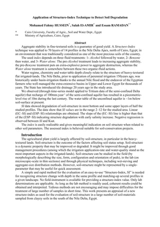
  • 4. Reconstructed Tritium Content in Nile water 1000 (425) an excluded value 100 Fahmy & R.Michel Old model TU measured 10 precipitation 1 1950 1960 1970 1980 1990 2000 Years Figure2. Tritium prediction model and data for the Nile water in both its head-reaches and in Egypt 1 1 2 Profile 1 2 Profile 1 3 3 4 4 5 5 6 7 Profile 2 6 7 Profile 2 8 8 9 9 10 10 11 Profile 3 11 Profile 3 12 12 13 13 14 14 15 15 16 Profile 4 16 Profile 4 17 17 index 18 Alchol 18 19 19 lowest 20 Water 20 21 Profile 5 21 Profile 5 highest 22 Benzine 22 23 23 mean 24 24 25 25 26 Profile 6 26 Profile 6 27 27 28 28 29 29 30 30 31 Profile 7 31 Profile 7 32 32 33 33 34 34 35 35 36 Profile 8 36 Profile 8 37 37 38 38 39 39 40 40 41 Profile 9 41 Profile 9 m 42 42 p b u n S o a r e s f l i m 43 43 p b u n S o a r e s f l i 44 44 45 45 46 Profile 10 46 Profile 10 47 47 48 48 49 49 50 Profile 11 50 Profile 11 51 51 52 52 53 53 54 54 55 Profile 12 55 Profile 12 56 56 57 57 58 58 59 59 60 60 61 Profile 13 61 Profile 13 62 62 63 63 64 64 65 65 66 Profile 14 66 Profile 14 67 67 68 68 69 69 70 70 0 10 20 30 40 50 60 70 0 1 2 3 4 5 6 7 8 9 10 11 12 Stable aggregates, % Structure index (the data-points representing the 5 surfac-layer samples (low = stable structure, high = poor stucture) are shown by triangle, orthogonal and squar symbols) Figure3. (Left) The sampled-layers are arranged in a (1-70) series and the three treatments are compared Figure4. (Right) The structure-index values are compared. The lowest, highest and mean values are shown. Four profiles (#1, 2, 8 and 11) have low values (2-5) (fully-good structure), seven profiles (# 3, 4, 7, 10, 12, 13 and 14) have moderate values (<8) (sensible-structure), and three profile (#5, 6 an 9) have high index-values (~12) (poor structure) 4
  • 5. It is suspected that 150years of perennial irrigation applied without adequate field drainage has imposed negative impact on the soil environment of the studied area. Tile drainage has been introduced 20years ago. The study area was functioning for thousands of years under the annual rhythm of once-per-year basin-irrigation water administration. That ancient water-regime was the direct result of the annual Nile flood into Egypt and the effort of Egyptian farmers who renewed and maintained, for thousands of years, the large-scale irrigation basins before each flood-season. Using a Tritium time-series data-set and curve-fitness exponential and dispersion models (Hussein, 1995) it is has been shown, Hussein et al, (1998) and Figure 2, that after the introduction of the perennial irrigation system, by the mid of the 19th century, the Delta aquifer became victim of over-recharge (up to 100mm/year) through non-point seepage from the cultivated fields (due to excessive irrigation water-application) and point seepage from irrigation-canals. Perennial irrigation allowed the cultivation of all the Nilotic land of Egypt the year-round. However, the water table was ~10m below soil-surface (150 years ago) whereas it is about ~1m at present. This recharge has increased aquifer storage by 200*109m3 under the Nile Delta (~22*103 km2 in area.) This sharp change in soil-water regime has accompanied the introduction of perennial irrigation and resulted elsewhere in the Nilotic Egypt, Hussein et al, (1998), in soil degradation. That degradation was mainly attributed to water-table rise (Hussein et al, 1998, 1999 and 2001 and Mohamed Fahmy Hussein, 2001). To conserve soil and to prevent environmental degradation, a huge tile-drainage project was initiated 20 years ago and should be accomplished by the year 2017. However, the maintenance of the installed tile-network continually seems a difficult task. The present work is concerned with soil-structure and its relation to soil-behavior in the study area. A host environmental study will be published elsewhere. A new technique, based on fluid treatment, is applied on seventy soil samples, from14 profiles as well as five surface-soil samples, in the Monofieyah Governorate at the Nile Delta apex north of Cairo, for the evaluation of the new index. The results are shown in Figures 3-12. Three five air-dry gram masses of each soil sample were treated as follows according to the “structure-index” of Mounier G., (1994): 1) Ethyl alcohol, followed by water, 2) Benzene then water, and 3) Water alone. Three sets of stable aggregates are obtained for each sample and a single parameter (structure-index, SI) is derived. The purpose of adding organic fluids (Ethyl Alcohol or Benzene) is to slow-down water- imbibition into soil aggregates. Ethyl alcohol completely mixes with water; it does not decrease cohesion; instead, it artificially increases aggregate-stability (due to air-escape without destroying the aggregates, so when water is subsequently added the aggregates do not suddenly explode. Consequently, the poor-structured soils may be compared). Benzene is, on the contrary, a non-polar and uncompressible fluid that does not mix with water. When water is next added, it pressurizes the Benzene entrapped into soil-pores, so the aggregates abruptly explode and only the very stable aggregates persist. Benzene is used for soils poor in organic-matter in order to increase the destructive power of water. In the case of organic-matter rich soils, Benzene will be fixed (on the O.M.) and aggregate-stability will not be affected; rather a gradual distribution of the structure- index will be obtained. Benzene application is usually used to study soils with O.M. of different origins. Adding water without previous treatment decreases cohesion so air is entrapped and aggregates readily explode. The formula used for the “structure index” (Mounier G., 1994) is: highest (silt+clay) ratio in 3 treatments Structure index = mean (stable aggregates+coarse sand) ratio in 3 treatments - (0.9 * C.S. ratio) The C.S. ratio is the coarse sand percentage in soil sample (determined according to the regular particle-size distribution lab procedure). The factor 0.9 is believed to slightly increasing the denominator in order to approach soil structure status under field conditions. When this formula produces a high value, this indicates soil structure deterioration. Observations and Interpretation 5
  • 6. Figure 1 demonstrates the study area. Figure 3 is shows the lowest percentages of stable- aggregates for the Benzene-treatment. These low percentages (min=0.8%, max=11% – with one exception of 19.8% for the surface layer of profile 5, sample #21,) represent the highly stable aggregates. The Alcohol-treatment has exaggerated the stable aggregates (min=16.4%, max=64.2%). The water only treatment (min=3.8%, max=33.4%) is between the Benzene and the Alcohol treatments. These observations show that the “three-fold-fluid treatment” is working fine. This single-parameter structure indicator is shown in Figures 3, 4 and 5 for the studied profiles. Each time the sable aggregates (Figure 3) decreases the structure-index (Figure 4) increases. Three profiles (# 2, 8 and 11) generally have low index-values (from ~2 to ~4) that reflect good structure. Eight profiles (#1, 3, 4, 7, 10, 12, 13 and 14) have moderate index-values (from ~3 to ~6) in most layers reflecting moderate to sensible structure, and three profiles (#5. 6 an 9) have moderate to high index-values (from ~4 to ~12) reflecting a mixture of sensible and poor structure. Some profiles (# 1, 5, 10, 11 and 12), Figures 4 and 5, have high index-values in the bottom layers, whereas other profiles (# 3, 7, 9 and 14) have high index-values also at the soil surface. Profiles #2, 4, and 6, 8, 13 have index-values oscillating between relatively low to relatively high throughout the sampled depths. Generally, it seems that soil degradation in the study area generally starts at profile bottom through contact with the water table, reception of the leachate from the upper layers and by the over-burden stresses. According to the obtained Structure-Index values, we introduce the following limits: (2-4%), (4-6%), (6-8%) and (8-12%) for the following four categories: Good, Moderate, Sensible and Poor structure, respectively. We used unpublished data, Hussein (1975), for soil structure evaluation of soils in the north of the Nile Delta using the structure-factor (SF) method where only water was used to determine the deflocculated clay percent. We calculated the term [(1/SF)*100]. A general trend of the increase of this term with depth is observed (Figure 6) with some exceptions. The structure-factor has a curvilinear relationship with the ESP (not shown) whereas the inverse term [(1/SF)*100] has a linear relationship with ESP (Figure 8). It seems that the structure-index method is more reliable and sensitive to show slight changes in soil structure than the structure-factor method; may be due to the implication of three fluids in the structure-index technique and its improved formula. The relationship of the structure-index, SI, with the ESP, Figure 7, is showing a linear positive trend (with the increase of the ESP, soil structure is degraded as shown by the increase of the SI value). However, the scatter is high; may be because ESP is just a factor, among others, affecting structure status. The scatter of data-points sharply increases when the ESP surpasses 15%. The relationship of SI with EC, Figure 9, is showing that the SI value increases with salinity increase. The scatter of data-points becomes high starting from EC of 4dS/m. When EC surpasses 16dS/m (not shown) the SI value decreases (apparent amelioration of structure probably due to excessive soluble salt-content that enhances cohesion of soil material). It is to be noticed that the very early increase in soil salinity produces rapid structure degradation. Nonetheless, neither salinity (EC) alone nor ESP alone, nor the two together, could be separately considered in data interpretation. The effect of these two factors could be understood in the general context of the drying-wetting cycles affecting soil moisture, irrigation intervals and chemical composition of soil-solution and all the other factors that may affect soil aggregation, including the microbial activity, temperature changes, degasing of soil air, O.M. content and composition, cultivation, management etc… since all these factors are continuously acting on the destruction and/or the reconstruction of stable aggregates, in the soil space- and time- continuum. The linear increase of the ln ESP with ln EC (Figure 10) is a common observation in the salt- affected soils. In that diagram we used non-published data (Hussein, 1975) and the wide-range of values is better appreciated through ln-transformation. The exchangeable (E”Ca+Mg”P), Figure 11, has a very sharp slope in the linear relationship with ESP, whereas the other exchangeable cations (ECaP, EMgP and EKP) have a less acute slope, a moderate slope and a very week slope, respectively. It is obvious that exchangeable Ca is the cation preferentially replaced by Na in these chemically deteriorated soils, followed by the exchangeable Mg. The CEC is weekly related to clay 6
  • 7. content (not shown) probably due to the dominance of clay-mineral type over clay content. The ESP is very weekly related to both clay percentage and CEC (not shown). Seemingly, this reflects that the relationship of these variables with the ESP is more defined by clay mineralogy (affecting the state of the diffuse electrical double-layer and the zeta potential) rather than by anything else. The log-transformation of (Ksat-ESP) data, Figure 12, resulted in improvement of the linear relationship. In the (logKsat-logESP) plot, linearity is shown with a strong scatter. A negative linear trend is obtained for the (logKsat-log SI) relationship, Figure 12. The high scatter says that the Ksat, ESP and SI values are affected by several factors, so a single relationship is a part of a complicated setup that cannot be defined by any single factor. Table 1 gives summary of the upper and lower limits of data. The values of Ksat have the highest ratio of the upper/lower limits (700 times). The ratio of the upper/lower limits for ESP and SI is comparable (nine and seven times, respectively.) Figure5. (Upper) Fourteen profiles are compared according to the structure-index values Figure6. (Lower) Five profiles are compared with respect to the inverse of the structure factor, (1/SF) *100 12 10 y = 0.124x + 2.696 20 R² = 0.243 y = 0.167x + 0.044 8 15 R² = 0.401 Structure 6 (1/SF ) 10 index *100 5 4 2 0 0 0 10 20 30 40 50 0 5 10 15 20 25 30 35 ESP ESP Figure7. (Left) The relationship of structure-index with ESP; scatter increases when ESP surpasses 15% Figure8. (Right) [(1/SF)*100] increases with ESP increase 7
  • 8. 12 4.5 4.0 y = 0.482x + 1.921 10 y = 0.295x + 3.250 R² = 0.579 R² = 0.233 3.5 8 this work 3.0 Structure 6 ln ESP 2.5 index 2.0 unpublished 4 1.5 data 2 1.0 linear fit 0 0.5 0 2 4 6 8 10 12 14 16 -0.5 0.0 0.5 1.0 1.5 2.0 EC, dS.m-1 ln EC, dS.m-1 Figure9. (Left) Relationship of the structure index with EC Figure10. (Right) Relationship between ESP and EC is shown by ln-transformation 100 90 80 70 X = Ca+Mg 60 regr. (ECa+MgP)-ESP EXP 50 X = Ca 40 regr. ECaP-ESP 30 X = Mg 20 regr. EMgP-ESP X=K 10 regr. EKP-ESP 0 0 20 40 60 80 100 ESP Figure11. Regressions of exchangeable cations. The slope of (EMgP-ESP) is one-third of that of (ESP-ECaP). The slope of (EKP-ESP) is 0.08 of that of (ESP-ECaP) 1.0 1.0 0.0 0.0 log -1.0 log Ksat -1.0 -2.0 Ksat -3.0 -2.0 0.5 1.0 1.5 2.0 -3.0 log ESP 0.0 0.5 1.0 this work unpublished data all Linear (all) log structure index Figure12 Log-transformations show decrease of (log K sat) with both (log ESP) and (log structure-index) increase Conclusions A new single-parameter indicator (the structure index, SI) was applied on 70 soil materials and proved informative and sensitive to soil structure status. The technique is simple, elegant and can be used on a routine-basis for soil conservation purposes. Soil degradation has several reasons. One of the most outstanding reasons for the alluvial soils in Egypt is related to water-table rise in the unconfined aquifer during the last 150years of perennial irrigation practice without installation of field-drainage network until 20years ago. Consequently, the over-recharge of the Delta semi- confined aquifer has taken place and manifested in rise of piezometric level of the upper (unconfined) aquifer. The present-day water-table level is below soil surface by ~1m (instead of 10m by the mid of the 19th century). The direct result of such situation is the increase of salt-content and development of high ESP. So, soil became under increasing chemical stresses that lead to deterioration of yield amount and quality. The obtained data show a positive linear relationship between EC and the ESP. The values of that structure index also illustrate positive linear relationships between the SI-values and both of the EC and the ESP. The SI surpasses the old (structure-factor) parameter in sensitivity. It is recommended to use the SI as a lab routine as it is successful for detecting soil structure degradation in its early and moderate stages. 8
  • 9. References Denef, K., J. Six, R. Merckx, and K. Paustian. 2003. Carbon sequestration in micro-aggregates of no-tillage soils with different clay mineralogy. Soil Sci. Soc. Am. J. 68:1935–1944 Diaz-Zoritaa,b, M., E. Perfect and J. H. Grove. 2002. Disruptive methods for assessing soil structure. Elsevier Science, 254-9 Edwards, A.P., and J.M. Bremner. 1967. Micro-aggregates in soils. J. Soil Sci. 18: 47-63. Eynard, A., T. E. Schumacher, M. J. Lindstrom, and D. D. Malo. 2004. Aggregate sizes and stability in cultivated south Dakota prairie Ustolls and Usterts. Soil Sci. Soc. Am. J. 68:1360–1365 Gabriels, D., and M. De Boodt. 1976 Report on the use of petroleum products for soil structure modification and soil conservation. Soil Physics lab, Rijks Univ. Gent. Gasperi-Mago, R.R., and F.R. Troeh. 1979. Microbial effects on soil erodibility. Soil Sci. Soc. Am. J. 43: 765-768. Harris, R.F., 6. Chester, and O.N. Alien. 1966. Dynamics of soil aggregation. Adv. Agron. 18: 107-169. Hussein, M. F, 1975. Morphological, physical and chemical changes associated with salinization process in Egyptian Alluvial Soils. M.Sc. Thesis, Cairo Univ., Fac. of Agric, Soil and Water Dept. 171p. Hussein, M. F. 1995. ”RIETHM”: Radioisotope environmental tracer hydrology model using the exponential and dispersion methods. In: First International Symposium on “Application of Tracers in Arid Zone Hydrology”, IAEA-IHA, Vienna, 15-26 August 1994. IAHS Publ. N. 232, 1995, Proceedings of the Vienna Symposium, August 1994, 211-224. Hussein, M. Fahmy and Michel, R. L., Froehlich, K. 1998. Historical isotopic changes in the River Nile and their relation to the study of ground-water hydrology of the Nile Valley and Delta. In: Gambling with Groundwater: Physical, Chemical, and Biological Aspects of Aquifer-Stream Relationships. International Association of Hydro-geologists. XXVIII Congress and Annual Meeting of the American Institute of Hydrology, Las Vegas, Nevada, USA. September 27-October 2, 1998, 105-110. Hussein, M. F., Frohlich, K., Nada, A., Atta, S.A. and Tanweer, A., 1998. Environmental isotopes and hydrochemistry of ground water in west El-Fashn and Maghagha regions, Isotope & Rad. Res., 30, 1-10. Hussein, M. Fahmy, Michel, R. L., Nada A., Froehlich, K., Atta, S. and Tanweer, A. 1999. Use of isotope geochemistry to determine the effectiveness of water management strategies, Nile valley, Egypt. In: International Symposium on Isotope Techniques in Water Resources Development and Management. Book of Extended Synopses, IAEA-SM-361, Vienna, Austria, 10-14 May 1999, pp 63-69. Hussein, M F, Fröehlich, K. and Nada A. 2001. Environmental isotope profiles and evaporation in shallow water-table soils. In: Isotope techniques in water resources investigations in arid and semi-arid regions, IAEA CRP 303-F3-Egy–7902/RB, IAEA-TECDOC-1207, March 2001, 27-31. Marquez, C. O., V. J. Garcia, C. A. Cambardella, R. C. Schultz, and T. M. Isenhart. 2004. Aggregate-size stability distribution and soil stability. Soil Sci. Soc. Am. J. 68:725–735 Mohamed Fahmy Hussein, 2001. Monitoring land and water degradation: Environmental dimensions and restoration. Sym. Nat. Res. & Their Conservation in Egypt & Africa, Inst. African Res. & Stud., Cairo Univ., 19-21 November 2001, 474-495 Monnier G. 1994. Assemblage et Organisation Physique des Particules.. In : Bonneua Maurice et Souchier Bernard (editors). Pédologie, Part 2. Constituants et Propriétés du sol, 2nd Edition, Masson, Paris, Milan and Barcelone, 665p (la méthode analytique de l'indice structural, page 346). Oades, J. M. 1984. Soil organic-matter and structural stability: mechanisms and implications for management. Plant and Soil 76, 319-337 9
  • 10. ‫فحص تقنية دليل بناء ‪Structure Index‬جديد لرصد تدهور الراضى‬ ‫**‬ ‫أ . د . محمد فهمى حسين* ، أ .د . صلح المير* ، م . عصام رمضان‬ ‫جامعة القاهرة ، كلية الزراعة ، قسم الراضى والمياه ، القاهرة ، مصر‬ ‫*‬ ‫وزارة الزراعة ، القاهرة ، مصر‬ ‫**‬ ‫ملخص‬ ‫تعتبر وفرة التجمعات البنائية الثابتة بالراضى ناعمة القوام ضمان ً أساسي ً لرفع جودة وانتاجية المحصولت‬ ‫ة‬ ‫ة‬ ‫الزراعية . استخدمنا تقنية "دليل بناء" جديد لتمحيصه كدليل يوضح حالة البناء فى أرا ٍ ُعتقد أنها تعرضت للتدهور بفعل‬ ‫ضي‬ ‫تغيير نظامها المائى . أجرينا العمل على سبعين عينة تربة رسوبية نهرية طينية-القوام من أربعة عشر قطاع ً وخمسة‬ ‫ا‬ ‫عينات سطحية بجنوب دلتا النيل، 05كم شمال القاهرة، بالقرب من نيل دمياط ، بمحافظة المنوفية، مصر، بمنطقة كانت تعد -‬ ‫لزمن ضارب فى ال ِدم - من أجود أراضى البلد .‬ ‫ق‬ ‫ُقدم هذا العمل نتائج الختبار المعملى لهذا المدليل . حصلنا على رقم الدليل بتنفيذ ثلث معاملت على كل عينة : )‬ ‫ي‬ ‫1- إضافة كحول ثم ماء ، 2- إضافة بنزين ثم ماء ، 3- المعاملة بالماء فقط( . تؤدى المعاملة المسبقة بالكحول إلى تعظيم‬ ‫مصطنع لثبات التجمعات، فى حين تؤدى المعاملة بالبنزين دورً عكسي ً )هو التحطيم الجائر للبناء، فل يتبقى سوى‬ ‫ا‬ ‫ا‬ ‫التجمعات الشد ثبات ً (، وتقع المعالجة بالماء فقط بمكان ما بين المعالجتين بهذين السائلين العضويين . وكلما زاد رقم الدليل‬ ‫ا‬ ‫دل ذلك على تدهور البناء .‬ ‫أوضحت البيانات وجود تدهور ملحوظ بالبناء فى نحو نصف عدد القطاعات محل الدراسة، حتى بالطبقات العليا، ل‬ ‫السفلى فقط . وظهر أن (دليل البناء) محل الدراسة ل يمتاز فقط بسهولة تنفيذه لمقارنة عدد كبير من العينات فى وقت‬ ‫قصير، بل أنه يعطى دللة أوضح من التى يعطيها (معامل البناء) التقليدى، كما يمكننا ربط هذا المؤشر الجديد بغيره من‬ ‫المتغيرات – كتملح وصودية التربة وتوصيلها الهيدروليكى المشبع – وهذا أمر هام، لما لتلك المتغيرات من علقة مباشرة‬ ‫بتدهور البناء بفعل التغيرات البيئية،كما يتسنى ادخال رقم هذا المؤشر – كدليل منفرد – ضمن المعالجة رقمية لقواعد‬ ‫بيانات الراضى، وربما يمكن استخدامه لحق ً فى النمذجة الفيزيائية والكيميائية وللمحاكاة الرياضية للراضى على الحاسب‬ ‫ا‬ ‫اللى .‬ ‫يرتبط بناء الراضى ثقيلة-القوام ارتباط ً وثيق ً بدينامية قطاع التربة )خصوص ً نظامه المائى وكيمياء المياه‬ ‫ا‬ ‫ا‬ ‫ا‬ ‫السطحية والجوفية( . لقد كانت دلتا النيل، قبل تعميم الرى الدائم بالراضى الرسوبية النهرية بمصر – منذ نحو 0٥1عام ً –‬ ‫ا‬ ‫خاضعة طوال تاريخ الزراعة المصرية للف السنين للرى الحوضى، بفضل فيضان النيل ونشاط الفلح المصرى الذى كلن‬ ‫يصون ويدعم جسور الحواض الضخمة كل عام . وللسف لم يتم تعميم الصرف الحقلى المغطى بالدلتا سوى مؤخرً )منذ‬ ‫ا‬ ‫نحو 02 عام ً (، فى حين تبدل النطام المائى للتربة، بشدة بفعل الرى المستديم، منذ نحو قرن ونصف .‬ ‫ا‬ ‫لوحظ – بتطبيق مودبل مناسب على متسلسلة زمنية لبيانات التريتيوم كنظير بيئى طبيعى مشع بالمياه الجوفية‬ ‫بدلتل النيل – أن الشحن الذى كان يتلقاه الخزان الجوفى السفلى )شبه-المحصور( قد ناهز 001مم/سنة )فى غيبة الصرف‬ ‫الحقلى طوال 0٢1عام ً(، مما أدى لرتفاع منسوب المياه بنحو عشرة أمتار بالخزان الجوفى )حر-السطح( الذى يعلو الخزان‬ ‫ا‬ ‫السفلى )شبه-المحصور(، عما كان عليه الحال قبل 0٥1عام ً )بمعنى أن الماء ربما كان على عمق عشرة أمتار فأصبح ل‬ ‫ا‬ ‫يتجاوز نحو متر واحد تحت سطح التربة حالي ً (، وإذا كان ذلك الشحن الجائر قد استمر لكان قد نشأ عنه ارتفاع منسوب‬ ‫ا‬ ‫المياه الجوفية بنحو متر آخر خلل عشرة أعوام، مما كان سيعنى تحول دلتا النيل بالكامل إلى مستنقعات غدقة منذ نحو عقد‬ ‫من الزمان .‬ ‫لحظنا ارتباط قيم دليل البناء )‪ (SI‬بتملح الترية )‪ (EC‬والصودية )‪ (ESP‬خطي ً ، وإن كانت نقاط البيانات فى‬ ‫ا‬ ‫العلقتبن )‪ (SI-EC‬و)‪ (SI-ESP‬عالية التبعثر خصوص ً بالمراحل المتأخرة من تزايد التملح والصودية . وكان ميل الخط )‪SI‬‬ ‫ا‬ ‫‪ (-EC‬أكبر من ميل الخط )‪ ،(SI-ESP‬مما يعنى أن تدهور التربة يظهر بمجرد بدء تملحها، أى قبل تحولها لر ٍ صودية ،‬ ‫ض‬ ‫01‬
  • 11. ‫ولحظنا أن تزايد التملح عن 61‪ dS/m‬قد أدى لنخفاض رقم الدليل )وهذا مجرد تحسن وهمى يطرأ على البناء لتزايد‬ ‫التماسك بفعل التملح المفرط( مما جعل الخط المستقيم يلتوى لسفل . لقد تراوحت قيمة رقم الدليل بين حوالى 2 ونحو 21 .‬ ‫كما ظهرت علقات خطية موجبة بين التملح )‪ (EC‬والصودية )‪ ،(ESP‬وانخفض التوصيل الهيدروليكى المشبع بنزايد رقم‬ ‫الدليل، ولحأنا لتحويل قيم التوصيل الهيدروليكى ودليل البناء والـ )‪ (ESP‬لوغاريتمي ً ليضاح النحدار خطى بينهما. وقارنا‬ ‫ا‬ ‫ُعامل البناء ‪ structure-factor, SF‬بدليل البناء ‪ structure-index, SI‬فوجدنا الخير أفضل .‬ ‫م‬ ‫لحظنا نفع وسهولة هذا الدليل كمؤشر منفرد يترجم حالة بناء التربة، ونعتقد أن هذا الدليل يفيد مشروعات تحسين‬ ‫وصيانة الراضى ثقيلة-القوام، خاصة المتأثرة منها بالملح، لن التعرف على مدى تدهور التربة هو العنصر الول‬ ‫المطلوب قبل الشروع فى تنفيذ أعمال التحسين .‬ ‫11‬