
Recomendados
Más contenido relacionado
Similar a POS (GNSS INS) System.pdf
Similar a POS (GNSS INS) System.pdf (20)
Último
Último (20)
POS (GNSS INS) System.pdf
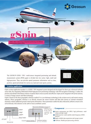
- 1. gSpin The GEOSUN GNSS / INS / multi-sensor integrated positioning and attitude measurement system (POS) gspin is divided into two series: light, small and high-precision. They can provide spatial parameter information such as time, position, speed and attitude for various air, land and water sports carriers. Aviation application Gspin aviation application product is a GNSS / INS integrated system designed and developed for direct geo referenced airborne sensor data. By integrating differential GNSS high-precision positioning technology with INS navigation technology, it makes the position and attitude information solution of spatial objects more accurate and efficient. Gspin can be integrated with aerial cameras, a variety of image sensors and lidar technology. Gspin is based on the direct geographic reference method. It is a revolutionary technology in the aviation survey and remote sensing industry. Direct geographic reference is to directly measure the sensor location and data (also known as external orientation elements) without additional ground control point information. These parameters enable the data collected by airborne sensors to be solved directly with reference to the earth or local coordinate system. Component Software: Shuttle post-processing software Highly reliable data acquisition and storage system usb typeC SD card slot Power Supply satellite trigger reserve PW/EVENT/PPS/RS232 Serial port Lemo9-core interface is used for power input, data input / output and c o m p u t e r communication / flight control mark point signal input Extension interface pps,event,rs232 Serial port External antenna interface GNSS / INS / multi-sensor integrated positioning and attitude measurement system (POS) Inertial measurement unit (IMU): high performance, small volume and light weight GNSS receiver: multi satellite multi frequency GNSS receiver
- 2. Land application Gspin high precision POS is a GNSS / INS / multi-sensor integrated system developed for manned motion carriers in the air, land and water. IMU mainly adopts optical fiber or laser gyro, and also supports more sensor data access, such as wheel counting. It can provide high-precision position and attitude information for the moving carrier, and can work effectively even under harsh GNSS observation conditions, such as urban canyon, viaduct, tunnel and forest. Gspin high-precision POS integrates INS navigation, Dr navigation, differential GNSS positioning, Kalman filtering and other technologies. It can solve and provide relevant motion state information of the carrier with high frequency, dynamic, high precision and high reliability. At the same time, it can also be used to provide auxiliary dynamic information for other sensor systems loaded by the motion carrier. Component Characteristic Characteristic Application Application Provide high-precision real-time or post solution for motion carrier It can replace aerial triangulation and comprehensive measurement of ground control points The existing DEM can be used for single stereo image pair model mapping and single chip correction Greatly improve the production efficiency and accuracy of traditional aerial mapping applications Easy integration with digital cameras, lidar and digital scanners Continuous positioning even during GNSS lockout Fast moving alignment Optional module combination Provide external time alignment interface Inertial measurement unit (IMU): high performance WS:Wheel sensor Shuttle Post processing software GNSS receiver: multi satellite multi frequency GNSS receiver It is especially suitable for sparsely populated areas without existing control points or applications requiring rapid response Aerial photogrammetry: a system that uses an airborne aerial camera to collect raw data, including DTM generation, orthophoto map generation, topographic map mapping, etc Lidar: a system that uses airborne lidar to collect raw data, including power patrol inspection, forestry investigation, environmental monitoring, topographic mapping, etc UAV multispectral / hyperspectral remote sensing: Forestry monitoring, water environment monitoring, agricultural investigation and monitoring High precision RTK or differential position and attitude measurement Manned aircraft photogrammetry and remote sensing Manned aircraft lidar Road topographic survey High precision vehicle dynamic test Rail geometric parameter information collection Intelligent transportation system (ITS) GIS data acquisition system Equipment model gSpin110 gSpin210 gSpin310 gSpin410 gSpin510 gSpin610 Data update frequency GNSS signal type Positioning accuracy (post-processing) Attitude accuracy (post-processing) Pitch / roll accuracy:0.025° Heading accuracy:0.080° Pitch / roll accuracy:0.015° Heading accuracy:0.040° Pitch / roll accuracy:0.005° Heading accuracy:0.017° Pitch / roll accuracy:0.003° Heading accuracy:0.01° Pitch / roll accuracy:0.003° Heading accuracy:0.008° Pitch / roll accuracy:0.002° Heading accuracy:0.005° 200Hz GPS L1/L2/L5 ; GLONASS L1/L2 ; B1C/B1/B2/B2a/B2b/B3 ; GALELEO E1/E5b/E5a Horizontal accuracy 0.02m; Elevation accuracy0.03m Parameter Wuhan Geosun Navigation Technology Co.,Ltd Web:www.geosunlidar.com Tel:86+027-87504895 Add: 4F, Building D, Maker plaza No.8 West Maodianshan Road, East Lake Hi-tech Zone Wuhan City, China