poster_EGU2016_def_web
•
0 recomendaciones•181 vistas

The document discusses food security challenges in the Sahel region of Africa. Agriculture is dependent on rainfall which is highly variable, resulting in potential crop failures and food crises. A crop risk zones monitoring system is proposed to help farmers plan planting times to minimize risks and maximize yields. The system would use satellite data and forecasting models to monitor the growing season and provide early warnings of dry spells or other risks so farmers can receive advice to improve food security and resilience. A prototype has been developed for Mali and Niger using open source tools to identify risk zones and support decision making.
Recomendados

Recomendados
Más contenido relacionado
La actualidad más candente
La actualidad más candente (6)
Destacado
Similar a poster_EGU2016_def_web
Similar a poster_EGU2016_def_web (20)
Más de Elena Rapisardi
Más de Elena Rapisardi (17)
poster_EGU2016_def_web
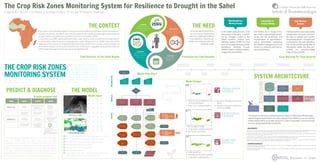
- 1. THE CONTEXT www.sensorwebhub.org contact person: t.de.filippis@ibimet.cnr.it Food Security in the Sahel Region AgricultureintheSahelianRegionischaracterizedbytraditionaltechniquesanditisstronglyde- pendent on climatic conditions and rainfall. In general, low rainfall during the growing season can bringtolowercropyieldsand,sometimes,tofoodcrises(Sultan,2005). Cropyieldsmaysuffersignificantlywitheitheralateonsetorearlycessationoftherainyseason, as well as witha highfrequencyofdamagingdryspells.(Mugalavaietal.,2008).Earlyrainsatthe beginningoftheseasonarefrequentlyfollowedbydryspellswhichmaylastaweekorlonger.As theamountofwaterstoredinthesoilatthistimeoftheyearisnegligible,earlyplantedcropscan sufferwatershortagestressesduringaprolongeddryspell. Consiglio Nazionale delle Ricerche Istituto di BiometeorologiaP. Vignaroli, L. Rocchi, T. De Filippis, V. Tarchiani, M. Bacci , P. Toscano, M. Pasqui, E. Rapisardi ThemainneedofSahelfarm- ersistoensureabetterfood security, adaptingtraditional cropcalendartoclimaticvari- abilitysotominimizerisksand maximizeyields. Prevention for Food Security PLANNING PREVENTION PLANNING PLANNING thechoiceofthe sowingdate abilitytoestimate effectivelytheonset oftheseason abilitytoestimate potentiallydangerous dryspells 01 advicestofarmersarea fundamentalcomponent ofprevention THE NEED The Crop Risk Zones Monitoring System for Resilience to Drought in the Sahel Mainly based on tools and models usingnumeric forecasts and satel- lite data to outlook and monitor thegrowingseason.Thisapproach is centered on the early identifica- tion of risks and the production of information within the time pre- scribed for decision-making (Vignarolietal.,2009). Early Warning Systems The MWGs are in charge of the agro-hydro-meteorologicalmoni- toring and the production and dissemination of agrometeoro- logical information supporting thedecisionmakingprocessfrom farmers to national and interna- tionalstakeholders. Information for Decision Making In the Sahel, particularly in CILSS (Permanent Interstates Commit- tee for Drought Control in the Sahel) countries, national Early Warning System (EWS) for food securityareunderpinnedbyMulti- disciplinary Working Groups (MWGs) lead by National Meteo- rologicalServices(NMS). Multidisciplinary Working Groups Early Warning for Food Security 2016 Vienna | 17 – 22 April MODULESOUTPUTS - geographical extent definition temporal extent definition crop and variety definition MODULE CHOICE INSTALLATION crop installation identification MONITORING season and crop monitoring FORECAST sowing and warning forecast advice choice phenological phases image installation phases image sowing condition forecast image installation date anomaly image soil available water image installation condition forecast image sowing failure image resowing image crop water needs satisfaction image crop water needs satisfaction forecast image crop water needs satisfaction forecast risk zone image RISK INFORMATION END END END START PRECONDITIONS ADVICE CROP INSTALLATION PHASE 1 ADVICE CROP VEGETATIVE PHASE 2 FARMERS EARLY WARNING SERVICES END MODE SCOPE ACTION USERS DIAGNOSTIC DROUGHT MONITORING CROP RISK ZONES IDENTIFICATION DROUGHT MANAGEMENT FOOD INSECURITY VULNERABILITY ASSESSMENT EXTENSION SERVICES AGRICULTURAL SERVICES PREDICTIVE SOWING ADVICE CROP STATUS PREDICTION PLANNINGFIELDWORK REDUCE SOWINGFAILURE CROP RISK ZONES MONITORING FARMERS EXTENSION SERVICES NATIONAL & REGIONAL EWSs NATIONAL EWSs REG/ INT ORGANIZATIONS & DONORS NAT/REG NETWORKS FOR FOOD CRISIS PREVENTION THE CROP RISK ZONES MONITORING SYSTEM The challenge and the objective of this work is to make avail- able for MWGs and any other local users an open access/sourceCropRiskZonesMonitoringSystem(CRZMS) supporting decision making for drought risk reduction and re- silience improvement. A first prototype has been developed for Niger and Mali NMSs, based on a coherent Open Source web-based infrastructure to treat all input and output data in an interoperable, platform-independent and uniform way. A multi purpose tool Model Input PREDICT & DIAGNOSE ABOUTTHE CRZMSTOOL THE MODEL MSGCumulatedRainfallEstimateImages (5–10dd) GFS Cumulated Precipitation Forecast (180 h) Monthly PET (Potential Evapo-Transpiration ) Average start of growing season Average end of Growing season Available soil moisture, Crops agronomic data - phenological phases: crop cycle length and cultural coefficient (Kc) Model Flow Chart SYSTEM ARCHITECTURE Model Output Created by Simple Icons TheSystemarchitectureandfunctionsarebasedonZAR(ZoneàRisque)agro- meteorological model where the data collected from different sources and the model output will be accessible using OGC (Open Geospatial Consortium) web servicesandgeospatialdatastandards. CRZMS increases the accessibility of the right drought risk informa- tion for different stakeholders; it provides specific advises for end- users at different decision-making levels, bridging the gap between available technology and local users’needs. PREVENTION FOOD MODEL CROP SOW EARLYWARNINGPHENOLOGYMONITORING RESILIENCE • Sowingadvices • Seedingsuccessfulprediction • Cropwaterstatusprediction FORECAST MODULE • Dateofcropinstallation and ofsowingfailures • Dateofre-sowingcondition • Actualvs.Averagecropinstal- lation • Actualvs.lastyearcropinstal- lationanomalies INSTALLATION MODULE • Phenological stage • Crop water satisfaction level • Soil water availability MONITORING MODULE BacciM.,DiVecchiaA.,GenesioL.,TarchianiV.,VignaroliP.,2009.IdentificationetSuividesZonesàRisqueagro-météorologiqueauSahel.In ChangementsGlobauxetDèveloppementDurableenAfrique,volume3.Rome,AracneEditrice.ISBN978-88-548-2980-0 MugalavaiE.M.,KipkorirE.C.,RaesD.,RaoM.S.,2008.Analysisofrainfallonset,cessationandlengthofgrowingseasonforwesternKenya.Ag- riculturalandforestmeteorology148:1123-1135. Sultan B., Baron C., Dingkuhn M., Sarr B., Janicot S., 2005. La variabilité climatique en Afrique de l’Ouest aux échelles saisonnière et intra- saisonnière.II:applicationsàlasensibilitédesrendementsagricolesauSahel.Sécheresse,16(1):23-33. VignaroliP.,TarchianiV.,BacciM.,DiVecchiaA.,2009.LaPréventiondescrisesalimentairesauSahel.InChangementsGlobauxetDèveloppe- mentDurableenAfrique,volume1.Rome,AracneEditrice.ISBN978-88-548-2894-0 BIBLIOGRAPHY This work was supported by the World Bank - Selection No. 1180159. The challange fund. “Building Resilience to Drought in the Sahel by EarlyRiskIdentificationandAdvices”. Thabks to Niger National Meteorological Service (DMN) and to Mali National Agency of Meteorology (MALI-METEO), Mali for their com- mitmentandcollaboration. CREDITS:IconsTheNounProjectbyStefanParnarov,KevinAugustineLO,SimpleIcons,PabloRozenberg,CreativeStall ACKNOWLEDGEMENTS Postgres SQL PostGIS GeoDatabase ZAR MODEL Specific servelets ETL procedures for data loading SYSTEM OUTPUTS Maps and Reports Download RS Rainfall images chains EUMETCast Receiving Station Backend beans/procedure (J2EE) BACKEND WebGIS Application View & Query Data USER INTERFACE FRONT END