Orienteering Mapping Using a GPS Watch
•Descargar como PPTX, PDF•
3 recomendaciones•2,813 vistas

Making orienteering maps is a passion of mine. Creating base maps using on-line tools has changed an expensive time consuming jobs in to a 'breeze'. However doing the field work to bring the map to what the orienteer sees on the ground remains a time consuming task. GPS enabled computer tablets work for some. I find a great time and technology saver is the easier to use GPS watch. Here's how.

Recomendados
Más contenido relacionado
La actualidad más candente
La actualidad más candente (20)
Similar a Orienteering Mapping Using a GPS Watch
Similar a Orienteering Mapping Using a GPS Watch (18)
Más de Gord Hunter
Más de Gord Hunter (14)
Último
Último (20)
Orienteering Mapping Using a GPS Watch
- 1. Orienteering Mapping Fieldwork Using a GPS Watch This works for me. It might work for you. Orienteering fieldwork using a tablet connected to a gps receiver in the field certainly has its advantages and is popular with all the best mappers. I have not had success with that method so I am using a GPS watch to record my tracks and plot information quickly and as accurately as ‘the other method’.
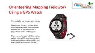
- 2. My current tracking watch is the Garmin Forerunner 235 set to record a point every second instead of the default every four seconds and set to pick up signals from GPS and GLONASS satellites. I have used Garmin Forerunner 405 and 610s. The 235 seems to be the most accurate of the bunch but I have no test data to that effect. I like the 235 because of the longer battery life and it is faster finding the satellites than my other watches. Did I mention that the tracking is very good? I also carry a copy of the map with a Mylar overlay and a set of colored pencils for note taking. Old school but it still does the job. Here is how I work it. . . .
- 3. Recently I came to a bit of terrain that I thought would benefit from a more accurate plotting of some distinctive bushes called saw palmettos. For a few years I have been using a special symbol for these bushes. The broad cross hatching is the local symbol for an area passable but dominated by these saw palmetto bushes. But as you can see at the top of this map it is possible to track the boundaries of the bushes.
- 4. Step 1: Visit the park and track the palmetto bush boundaries. Take time to go around corners and change directions. Even at one second recording the gps will ‘generalize’ a route too much if I am too fast. Step 2: Return home and upload this and other tracks to Garmin Connect. Do not worry that at this scale the tracks just look like a pile of red spaghetti.
- 5. From the Garmin Connect drop down menu I select to send the information back to my mapping computer as a gpx file. These files get stored in a folder I set up for them. By default if nothing else is chosen the computer will save them in the Download folder. Garmin Connect gives each track a distinct number. My first track in 2013 was activity_408780743. Now they are up over 3 Billion!!
- 6. OCAD 12 is my mapping program. I think this works the same with other programs, too. GPS tracks may be imported and often can be immediately converted to another symbol such as a trail, field or other line or area object. However I prefer to lay the track in place and trace the desired map symbol along the track. Note: The feature we are working on is a plant called saw palmetto. They grow in clumps and are a ‘difficult to pass’ vegetation feature. To not confuse them with other thickets Suncoast Orienteering gives them their own symbol.
- 7. Import track to map Trace in desired symbol Take away the track Mapping the Palmetto Clumps The result is a detailed mapping of the palmetto bushes. Once the map drawing is complete the gps track can be removed.
- 8. Another Example: The GPS watch tracking can be used for point, line and area features. Here on the left I walked along a vegetation line, turned to walk a trail, switched to a less distinct trail and at one point left the trail with an out/back track to locate a significant tree. The resulting map features are on the right. Written notes help keep track of the features being mapped.
- 9. Still Another Example: Tracking accompanied by mapping with base map, mylar and colored pencils. Combines line, point and area features.
- 10. • Track the activity on a GPS watch • Take notes of what is being tracked • Upload track to Garmin Connect or another service • Download the track as a gpx file to a computer • Import the track to the mapping program. If the map is geo-referenced the track will fall in place. If the map is not geo-referenced the track can be dragged and dropped in to place. In the latter case it is best to have clearly identified start and finish points for your track. • Trace in the desired detail from the track. • A single purpose track or portions of the track, such as of a trail or a field boundary, can be directly converted to the OCAD symbol. Review Gord Hunter Suncoast Orienteering