
Recomendados
Más contenido relacionado
La actualidad más candente
Destacado
Destacado (20)
Similar a The State of Fukushima 2015
Similar a The State of Fukushima 2015 (15)
The State of Fukushima 2015
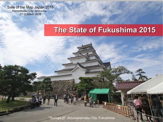
- 1. “Tsuruga-jō” Aizuwakamatsu City, Fukushima The State of Fukushima 2015The State of Fukushima 2015 Sate of the Map Japan 2015 Hamamatsu City, Shizuoka 31 October 2015
- 2. 'Where did you contribute to OpenStreetMap? ' http://yosmhm.neis-one.org/?ikiya I live in Fukushima, Japan. I've mapped Japan, Asia, the Middle East, Haiti, New Zealand, and other countries. Self-introduction
- 3. 片手に GPSロガー3機 I'm a Crazy Mapper :) Self-introduction http://hdyc.neis-one.org/ 1、2、3 4.GPSスマホ 5、GPS、コンパス モーションセンサー付き デジカメ ※バッグには 予備バッテリー群 お水・お薬 【日常のマッパひとり歩き姿】
- 4. 福 島 Fukushima, Japan Hanamiyama Fukushima City, Japan. Photo by Miyamori 福島市 花見の名所 花見山です。
- 5. © OpenStreetMap contributors Tokyo 福島市 Fukushima Japan 浜松市 Hamamatsu
- 6. About 1,900,000 people live in the Fukushima area. 福島市 Fukushima City © OpenStreetMap contributors, CC BY-SA This is the Fukushima area. 福島県の人口は約190万人です。
- 7. I started OSM in 2008. There were hardly any maps of Japan and my town then. Fukushima in 2008 © OpenStreetMap contributors 2008年当時の福島県OpenStreetMapです。
- 8. Fukushima in 2015 © OpenStreetMap contributors We spent many hours mapping towns in Fukushima. 2015年現在の福島県OpenStreetMapです。
- 9. 2011東日本大震災 2011 Tohoku, Japan Earthquake, Tsunami Fukushima
- 10. 2011 A huge earthquake and tsunami hit the region, causing major damage. A nuclear accident also occurred. 2011年33月月1111日日 東日本大震災東日本大震災 長く続く強烈な揺れとその後の大津波が長く続く強烈な揺れとその後の大津波が 甚大な被害をもたらせました。甚大な被害をもたらせました。 さらには未曽有の原子力災害が起きました。さらには未曽有の原子力災害が起きました。
- 11. Geospatial Information Authority of Japan(GSI) http://www.gsi.go.jp/chibankansi/chikakukansi_tohoku2.html ”平成23年(2011年)東北地方太平洋沖地震に伴う地殻変動について”国土地理院 平成23年3月19日発表 The land in the Tohoku region moved to the south-east in the earthquake. Ishinomaki City in Miyagi Prefecture moved up to 5.3meters. 地殻は大きく変動しました。 石巻市で最大5.3m南東方向へ移動 5.3m
- 13. The Fukushima coastline is 130km long. 130km 震災前にGPSログでのマッピングを行っていました。 We mapped the Fukushima coastline before the Disaster. These areThese are mapping GPS logsmapping GPS logs..
- 14. 津波は多くのものを破壊し海へと連れ去っていきました。 The tsunami destroyed everything and the receding wave carried much of the debris out to sea. Photo : After the disaster / Iwaki City, Fukushima
- 15. 長年、GPSマッピングした地区も多くが流され跡形もなくなりました。 This area I spent several years mapping has all but disappeared. All houses and highways were washed away. ピンクのラインは震災前に記録したGPSログです。 被災前には住宅地、耕作地が広がっていました。
- 16. 津波前 と 津波被災後津波前 と 津波被災後 You can see the remains of the yellow center lineYou can see the remains of the yellow center line and the foot path in the bottom pictureand the foot path in the bottom picture (Before the disaster) (After the disaster)
- 17. These photos were taken from the same spot.These photos were taken from the same spot. (Before the disaster) (After the disaster) 延々と続いていた松林もすべて流され荒涼とした湿地とかわりました。
- 18. 原子力災害 Nuclear Disaster Fukushima IFukushima I Nuclear Power PlantNuclear Power Plant 20km20km evacuation zoneevacuation zone © OpenStreetMap contributors
- 19. 原子力災害が起こった直後、多くのマッパーが原子力発電所のマッピングを行いました。 A nuclear accident followed the earthquake. Many mappers mapped the Fukushima nuclear power plant. http://tools.geofabrik.de/mc/#15/37.4222/141.0274&num=2&mt0=mapnik&mt1=google-map
- 24. LOGO ”現在の空間線量率は10μSv/hですが、 胸部レントゲン検査での被ばく量50μSv/回に比べれは問題ありません。” 空間線量率は時間当たり、 1日24hなら10×24=積算240μSv そこに3日いれば240×3=積算720μSv ”毎日家族全員がレントゲン5回撮っている状態” ????? 【 注 意 】 ただし、この空間線量率は屋外高さ1mで計測したもので、屋内生活、生活移動を 加味すると予測値計算には現在、補正係数o.6をかけます。 実際の計測による外部被ばく量はこの予測値よりもさらに低いことが確認されています。 ”外部被ばく量は単純に空間線量率×時間×日数ではないこと” をご理解ください。 当時考えた内容
- 31. GPS+Radiation level+Voice recorder I mapped the radiation levels in Fukushima. 知識も技術、機器も手探りの中、マッパー技量で空間線量率の簡易測定を行いました。 Radiation Mapping
- 35. ArcGIS Online Map:© OpenStreetMap contributors
- 36. CSV Data
- 37. 2,400 km 7,000 waypoints Waypoints Number + Radiation Level Map:© OpenStreetMap contributors
- 38. Fukushima 2015 4 years has passed since the disaster.
- 39. Fukushima 2015 The people living in Fukushima have mostly settled down to a normal life again. But, nearly 120,000 people who were evacuated still have to remain in temporary emergency housing. 4年たって人々の生活は落ち着きを取り戻しつつあります。 しかし、まだ約12万人の避難者、仮設住宅暮らしの方々が いらっしゃいます。
- 40. May 2015 After the disaster Tsunami damage Restoration construction has advanced along the coast which was hit by the tsunami. These photos were taken from the same spot. 復旧工事は一歩一歩前に進んでいます。
- 41. 震災直後の深刻な状況から今ではより良い状況へと 戻りつつあります。多くの支援に感謝致します。 Although conditions were very bad right after the disaster, things have gradually been getting better. We are thankful for this.
- 44. In Fukushima we held many mapping partys. ローカルなマッピングパーティーをチョコチョコ開催しては、 福島県内を駆け回っています。
- 45. http://wiki.openstreetmap.org/wiki/JA:Ouchi-juku_Mapping_Party_20141108 「大内宿マッピングパーティー」Ouchi-juku Mapping Party! Ouchi-juku is a historical small town. (Beautiful wooden town!) We mapped buildings, roads and many fire-hydrant. http://www.osmhydrant.org/en/#zoom=18&lat=37.333742&lon=139.860956 歴史的景観を守ってきた大内宿で街並み全体と消火栓マッピングを行いました。 Map:© OpenStreetMap contributors
- 46. http://sotm-eu.org/en/pages/posters SotM-EU2014 KARLSRUHE 13-15 JUNE 14 Last year we won the first prize in SotM EU Poster Competition. We appreciate it! 昨年ドイツで開催されました 欧州OSMカンファレンス 「SotM EU 2014」 OSMポスターコンペに OSM福島でエントリー 欧州勢を抑えて 得票115票で第一位!受賞しました。 感謝!
- 51. 鶴ヶ城 Tsuruga-jo Castle in Aizu Wakamatsu, Fukushima This is Tsuruga-jo Castle in Aizu Wakamatsu, Fukushima. You may have heard of Tsuruga-jo Castle through OSM :)
- 52. Tsuruga-jo Castle in Aizu Wakamatsu, Fukushima 長い時間をかけて私たちは鶴ヶ城をマッピングしてきました。 We spent many hours mapping this beautiful castle.
- 55. “JOSM勉強会”グループ ふくしまローカルなOSM勉強会・仲間たち https://www.mapillary.com/map © Mapbox © OpenStreetMap
- 56. “JOSM勉強会”グループ ふくしまローカルなOSM勉強会・仲間たち https://www.mapillary.com/map © Mapbox © OpenStreetMap
- 58. "ハザードマップ Hazard Map" Aizu-Wakamatsu City Fukushima, Japan
- 59. December 2014, Aizu-Wakamatsu City Crisis Management Division made "Home Disaster-Prevention Chart" and "Hazard Map".(Fukushima,Japan) 会津若松市「家庭用防災カルテ」・「ハザードマップ」 2014年12月、会津若松市 危機管理課は、 災害に備えた情報と避難に関する情報(土砂・水害エリア、避難施設等)を市民に提供し、 的確かつ迅速な避難行動ができるよう啓発することを目的として、 「家庭用防災カルテ」・「ハザードマップを作成しました。
- 60. The base map of these maps has used road and building data of OpenStreetMap, and is made up in the form of overlapping the disaster information that is provided by the National and Fukushima Prefecture. "ハザードマップ" (A1 594*841mm) "家庭用防災カルテ" (A1 594*841mm) 地図情報のベースマップには、OpenStreetMapの道路及び建物データが使用されており、 国や福島県などが提供している災害情報を重ねる形で構成されています。 OSMデータや各種の防災情報を重ねて地図画像化する作業はQGISを使用して行われています。
- 61. These Paper Maps were enclosed in News of Municipal Government and distributed to all households of Aizu-Wakamatsu City. (50,000 copies!) "News of Municipal Government from Aizu-Wakamatsu City” (December 2014) 「家庭用防災カルテ」・「ハザードマップ」は、2014年12月1日配布の会津若松市 市政だよりに同封され、 市内全世帯にそれぞれ5万部が配布されました。
- 62. Thank you ! Sate of the Map Japan 2015 Hamamatsu City, Shizuoka 31 October 2015